
Technology Metal Potential Identified at Taronga
Summary by AI BETAClose X


9 July 2026
First Tin PLC
("First Tin" or "the Company")
Rare Earth Element and Technology Metal Potential Identified within Taronga Tenement Package
First Tin PLC, a tin development company focused on advancing low-capex projects in Australia and Germany, is pleased to announce that its wholly owned subsidiary, Taronga Mines Pty Ltd ("TMPL"), has identified potential for rare earth elements ("REEs") and technology metals within its Taronga tenement package.
The mineralisation described below was discovered at one of the Company's recently acquired tenements by First Tin geologists while sampling old workings for tin mineralisation and subsequently named the Blatherarm Prospect. As shown in Figure 1, Blatherarm is located approximately 20km northeast from the Taronga Tin Project.
Blatherarm REE Target:
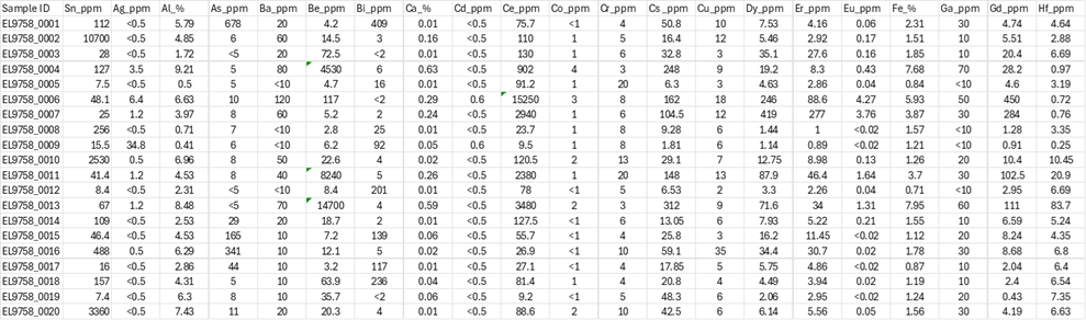
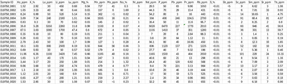
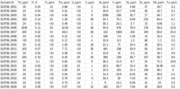
Rock chip sampling has returned very high REE and technology metal assays from pegmatitic and biotitic zones within the highly radiometric Mole Leucogranite (Figure 1) including the following:
· Be (beryllium) 4530, 8240 and 14700 ppm (1.47%)
· Ce (cerium) 2380, 2940, 3480 and 15250 ppm (1.52%)
· Cs (caesium) 104.5, 148 and 312 ppm
· Dy (dysprosium) 246 and 419 ppm
· Er (erbium) 46.4 and 88.6 ppm
· Eu (europium) 3.76 and 4.27 ppm
· Gd (gadolinium) 284 and 450 ppm
· Hf (hafnium) 20.9 and 83.7 ppm
· Ho (holmium) 35.8 and 87.5 ppm
· La (lanthanum) 1100, 1080 and 5350 ppm
· Lu (lutetium) 11.8 and 47.4 ppm
· Nd (neodymium) 806, 1135, 1165 and 5020 ppm
· Pr (praseodymium) 104.5, 271, 404 and 1770 ppm
· Rb (rubidium) 1225, 1280, 2010, 2550 and 2700 ppm
· Sm (samarium) 182, 229, 301 and 946 ppm
· Tb (terbium) 15.2, 56.6 and 59.7 ppm
· Tm (thulium) 12.9 and 46.3 ppm
· Y (yttrium) 208, 229, 291, 338, 676 and 1900 ppm
· Yb (ytterbium) 31.4, 46.7, 53.9, 79.8 and 318 ppm
The results demonstrate the presence of a broad suite of rare earth elements, including the more valuable heavy rare earths such as dysprosium, lutetium, neodymium, praseodymium, terbium and thulium. In addition, several valuable technology metals, including beryllium, caesium, hafnium and rubidium were identified in the same samples.
While the extent, continuity and economic significance of the mineralisation have not yet been established, soil and rock chip sampling based on dysprosium assays has identified several zones exceeding 100m in strike length, with soil results above 16ppm Dy and rock chip assays of up to 419ppm Dy (Figure 2).
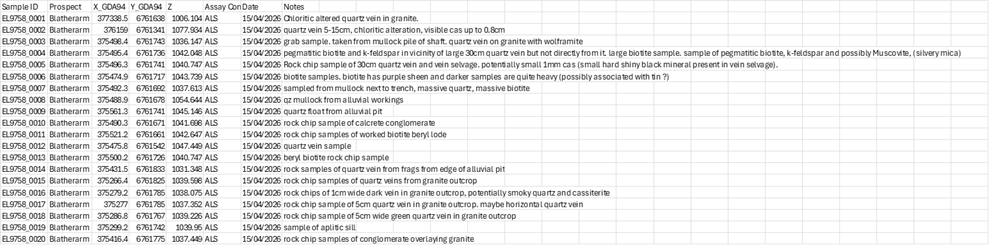
All rock chip assay results are appended at the end of Table 1.
These findings have potential broader strategic significance beyond the immediate exploration upside. The identification of a wide suite of rare earth elements and technology metals alongside the primary tin operation highlights potential additional exploration opportunities within the Company's broader critical minerals portfolio. REEs such as neodymium, praseodymium and dysprosium are fundamental to the production of high-performance magnets used in electric vehicles, wind turbines and advanced electronics.
Blatherarm Tin/Tungsten Target:
In addition to the REE and technology metal potential, coarse cassiterite and wolframite mineralisation has been located near old mines within a zone of thick but widely spaced sheeted veins within the Mole Leucogranite. Soil sampling has returned a north-south trending zone 200m long and 30m wide at plus 200ppm tin ("Sn") (Figure 3). A secondary 160m by 80m Sn anomaly exceeding 200ppm Sn (maximum 1,130ppm Sn) has also been identified around 70m to the northwest. Rock chip samples have returned up to 0.34% Sn and 0.26%W.
First Tin CEO, Bill Scotting, commented:
"While our primary focus remains advancement of our Taronga Tin Project towards production, identification of significant REE and technology metal mineralisation within our extensive tenure around Taronga is highly encouraging. These materials are also essential for fast-growing industries such as electrification, renewable energy and advanced manufacturing, where demand is being driven by structural global growth trends.
"Our strategy is centred on building a portfolio of critical mineral assets in stable, low-risk jurisdictions. In a market increasingly focused on secure, diversified and responsible supply chains, results such as these continue to build a case for the broader potential within our Australian footprint for supply of critical minerals.
"Next steps at this target will include more detailed geological mapping, extending the soil and rock chip sampling and working up of drill targets."
Competent Person Statement
Information in this announcement that relates to exploration results, data quality and geological interpretations is based on information compiled by Mr Antony Truelove. Mr Truelove is a Member of the Australian Institute of Geoscientists (AIG) and the Australasian Institute of Mining and Metallurgy (AusIMM). Mr Truelove has sufficient experience relevant to the style of mineralisation and type of deposit under consideration, and to the activities undertaken, to qualify as a Competent Person as defined in the 2012 Edition of the Joint Ore Reserves Committee (JORC) Australasian Code for Reporting of Exploration Results, Mineral Resources and Ore Reserves. Mr Truelove is Chief Operating Officer of First Tin Plc and consents to the inclusion in this announcement of the matters based on this information in the form and context in which it appears.
Enquiries:
|
|
|
|
First Tin |
Via SEC Newgate below |
|
Bill Scotting - Chief Executive Officer
|
|
|
Arlington Group Asset Management Limited (Financial Advisor and Joint Broker) |
|
|
Simon Catt
|
+44 (0)20 7389 5016 |
|
Tamesis Partners LLP (Joint Broker) |
+44 (0) 20 3882 2868 |
|
Richard Greenfield / Charlie Bendon |
|
|
|
|
|
Zeus Capital Limited (Joint Broker) |
+44 (0)20 3829 5000 |
|
Harry Ansell / Dan Bristowe / Katy Mitchell
|
|
|
SEC Newgate (Financial Communications) |
|
|
Elisabeth Cowell / George Esmond / Gwen Samuel |
+44 (0)7540 106366 firsttin@secnewgate.co.uk |
Notes to Editors
First Tin PLC is an ethical, reliable, and sustainable tin production company led by a team of renowned tin specialists. The Company is focused on becoming a tin supplier in conflict-free, low political risk jurisdictions through the rapid development of high value, low capex tin assets in Germany and Australia, which have been de-risked significantly, with extensive work undertaken to date.
Tin is a critical metal, vital in any plan to decarbonise and electrify the world, yet Europe and North America have very little supply. Rising demand, together with shortages, is expected to lead tin to experience sustained deficit markets for the foreseeable future.
First Tin's goal is to use best-in-class environmental standards to bring two tin mines into production in three years, providing provenance of supply to support the current global clean energy and technological revolution.
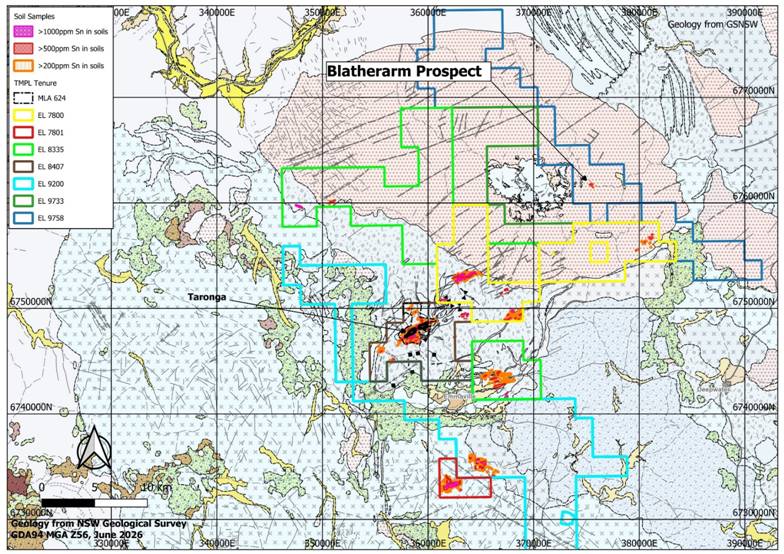
Figure 1: Blatherarm Prospect Location Plan
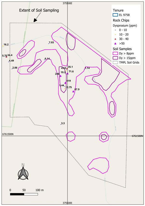
Figure 2: Blatherarm Prospect - Dysprosium Soil and Rock Chip Sampling (results in ppm Dy)
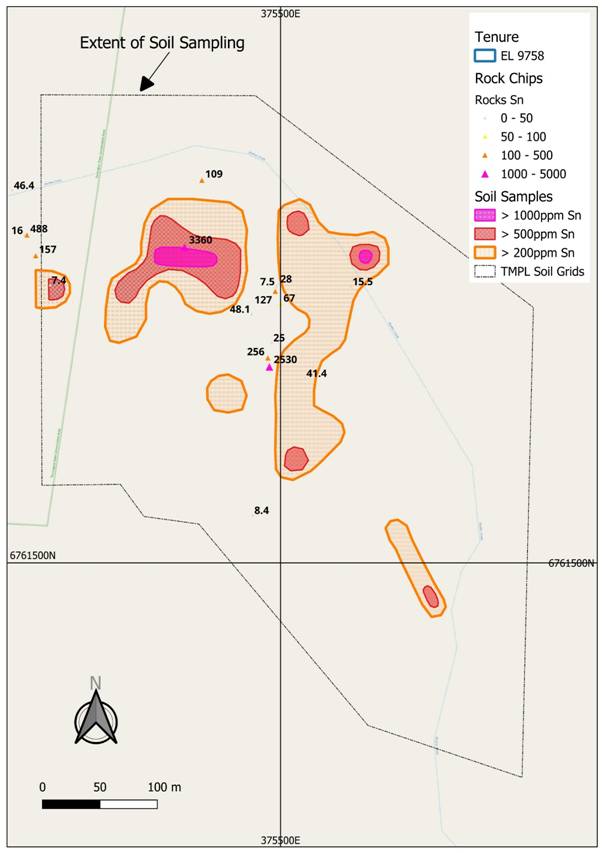
Figure 3: Blatherarm Prospect - Tin Soil and Rock Chip Sampling (results in ppm Sn)
JORC Code, 2012 Edition - Table 1 Blatherarm Sn-REE Prospect
Section 1 Sampling Techniques and Data
(Criteria in this section apply to all succeeding sections.)
|
Criteria |
JORC Code explanation |
Commentary |
|
Sampling techniques |
· Nature and quality of sampling (e.g. cut channels, random chips, or specific specialised industry standard measurement tools appropriate to the minerals under investigation, such as down hole gamma sondes, or handheld XRF instruments, etc). These examples should not be taken as limiting the broad meaning of sampling. · Include reference to measures taken to ensure sample representivity and the appropriate calibration of any measurement tools or systems used. · Aspects of the determination of mineralisation that are Material to the Public Report. · In cases where 'industry standard' work has been done this would be relatively simple (e.g. 'reverse circulation drilling was used to obtain 1 m samples from which 3 kg was pulverised to produce a 30 g charge for fire assay'). In other cases, more explanation may be required, such as where there is coarse gold that has inherent sampling problems. Unusual commodities or mineralisation types (e.g. submarine nodules) may warrant disclosure of detailed information. |
· Sampling consisted of: o Soil sampling consisting of collection of approximately 500-1000g sample from the B-horizon, approximately 20cm below surface at a density of approximately 30m x 30m. These are considered representative of the soil profile in the area. o Rock chip sampling consisting of collection of random selected samples from mine dumps, old workings and outcrop. Weights ranged from 0.5 to 3.1kg. These are not considered representative of the area as a whole and are likely to have focussed on higher than average grade mineralisation. |
|
Drilling techniques |
· Drill type (e.g. core, reverse circulation, open-hole hammer, rotary air blast, auger, Bangka, sonic, etc) and details (e.g. core diameter, triple or standard tube, depth of diamond tails, face-sampling bit or other type, whether core is oriented and if so, by what method, etc). |
· No drilling has been undertaken at this stage. |
|
Drill sample recovery |
· Method of recording and assessing core and chip sample recoveries and results assessed. · Measures taken to maximise sample recovery and ensure representative nature of the samples. · Whether a relationship exists between sample recovery and grade and whether sample bias may have occurred due to preferential loss/gain of fine/coarse material. |
· N/A |
|
Logging |
· Whether core and chip samples have been geologically and geotechnically logged to a level of detail to support appropriate Mineral Resource estimation, mining studies and metallurgical studies. · Whether logging is qualitative or quantitative in nature. Core (or costean, channel, etc) photography. · The total length and percentage of the relevant intersections logged. |
· Rock chip samples were geologically described as per the attached table. |
|
Sub-sampling techniques and sample preparation |
· If core, whether cut or sawn and whether quarter, half or all core taken. · If non-core, whether riffled, tube sampled, rotary split, etc and whether sampled wet or dry. · For all sample types, the nature, quality and appropriateness of the sample preparation technique. · Quality control procedures adopted for all sub-sampling stages to maximise representivity of samples. · Measures taken to ensure that the sampling is representative of the in-situ material collected, including for instance results for field duplicate/second-half sampling. · Whether sample sizes are appropriate to the grain size of the material being sampled. |
· N/A |
|
Quality of assay data and laboratory tests |
· The nature, quality and appropriateness of the assaying and laboratory procedures used and whether the technique is considered partial or total. · For geophysical tools, spectrometers, handheld XRF instruments, etc, the parameters used in determining the analysis including instrument make and model, reading times, calibrations factors applied and their derivation, etc. · Nature of quality control procedures adopted (e.g. standards, blanks, duplicates, external laboratory checks) and whether acceptable levels of accuracy (i.e. lack of bias) and precision have been established. |
· All assays were undertaken at ALS in Brisbane using method ME-ICP61 or ME-MS81 as appropriate. Tin and REEs were assayed by method ME-MS81. |
|
Verification of sampling and assaying |
· The verification of significant intersections by either independent or alternative company personnel. · The use of twinned holes. · Documentation of primary data, data entry procedures, data verification, data storage (physical and electronic) protocols. · Discuss any adjustment to assay data. |
· All data is stored in the original format supplied by ALS as well as a combined "Master Database" in Excel and CSV format for each of soils and rock chips. |
|
Location of data points |
· Accuracy and quality of surveys used to locate drill holes (collar and down-hole surveys), trenches, mine workings and other locations used in Mineral Resource estimation. · Specification of the grid system used. · Quality and adequacy of topographic control. |
· Sample locations were surveyed using a hand held GPS accurate to within 5m. Locations are stored with the assay data in the master databases. Locations are presented on the figures in the main document. |
|
Data spacing and distribution |
· Data spacing for reporting of Exploration Results. · Whether the data spacing and distribution is sufficient to establish the degree of geological and grade continuity appropriate for the Mineral Resource and Ore Reserve estimation procedure(s) and classifications applied. · Whether sample compositing has been applied. |
· Soil samples are at approximately 30m x 30m spacing. · Rock chips are at random locations as shown on the figure in the main document. |
|
Orientation of data in relation to geological structure |
· Whether the orientation of sampling achieves unbiased sampling of possible structures and the extent to which this is known, considering the deposit type. · If the relationship between the drilling orientation and the orientation of key mineralised structures is considered to have introduced a sampling bias, this should be assessed and reported if material. |
· The 30m x 30m pattern means no bias is expected. |
|
Sample security |
· The measures taken to ensure sample security. |
· A chain of command is maintained from site to the laboratory. |
|
Audits or reviews |
· The results of any audits or reviews of sampling techniques and data. |
· None. |
Section 2 Reporting of Exploration Results
(Criteria listed in the preceding section also apply to this section.)
|
Criteria |
JORC Code explanation |
Commentary |
|
Mineral tenement and land tenure status |
· Type, reference name/number, location and ownership including agreements or material issues with third parties such as joint ventures, partnerships, overriding royalties, native title interests, historical sites, wilderness or national park and environmental settings. · The security of the tenure held at the time of reporting along with any known impediments to obtaining a licence to operate in the area. |
· All samples are located on EL 9758 held 100% by Taronga Mines Pty Ltd. This is currently in good standing with the NSW authorities. |
|
Exploration done by other parties |
· Acknowledgment and appraisal of exploration by other parties. |
· None known. |
|
Geology |
· Deposit type, geological setting and style of mineralisation. |
· The mineralisation is associated with sheeted quartz veins, pegmatites and biotitic shear zones within the Mole Leucogranite, a highly radiometric granite in the New England district of NE NSW. |
|
Drill hole Information |
· A summary of all information material to the understanding of the exploration results including a tabulation of the following information for all Material drill holes: o easting and northing of the drill hole collar o elevation or RL (Reduced Level - elevation above sea level in metres) of the drill hole collar o dip and azimuth of the hole o down hole length and interception depth o hole length. · If the exclusion of this information is justified on the basis that the information is not Material and this exclusion does not detract from the understanding of the report, the Competent Person should clearly explain why this is the case. |
· No drilling undertaken. |
|
Data aggregation methods |
· In reporting Exploration Results, weighting averaging techniques, maximum and/or minimum grade truncations (e.g. cutting of high grades) and cut-off grades are usually Material and should be stated. · Where aggregate intercepts incorporate short lengths of high grade results and longer lengths of low grade results, the procedure used for such aggregation should be stated and some typical examples of such aggregations should be shown in detail. · The assumptions used for any reporting of metal equivalent values should be clearly stated. |
· N/A |
|
Relationship between mineralisation widths and intercept lengths |
· These relationships are particularly important in the reporting of Exploration Results. · If the geometry of the mineralisation with respect to the drill hole angle is known, its nature should be reported. · If it is not known and only the down hole lengths are reported, there should be a clear statement to this effect (e.g. 'down hole length, true width not known'). |
· N/A |
|
Diagrams |
· Appropriate maps and sections (with scales) and tabulations of intercepts should be included for any significant discovery being reported These should include, but not be limited to a plan view of drill hole collar locations and appropriate sectional views. |
· See main document for plans and addendum for table. |
|
Balanced reporting |
· Where comprehensive reporting of all Exploration Results is not practicable, representative reporting of both low and high grades and/or widths should be practiced to avoid misleading reporting of Exploration Results. |
· All results are reported. |
|
Other substantive exploration data |
· Other exploration data, if meaningful and material, should be reported including (but not limited to): geological observations; geophysical survey results; geochemical survey results; bulk samples - size and method of treatment; metallurgical test results; bulk density, groundwater, geotechnical and rock characteristics; potential deleterious or contaminating substances. |
· Geological observations reported in addendum. |
|
Further work |
· The nature and scale of planned further work (e.g. tests for lateral extensions or depth extensions or large-scale step-out drilling). · Diagrams clearly highlighting the areas of possible extensions, including the main geological interpretations and future drilling areas, provided this information is not commercially sensitive. |
· The soil grid is proposed to be extended and additional mapping and sampling undertaken. This will be used to plan follow-up drilling programmes. |
ADDENDUM: Rock Chip Sampling Description and Results
RNS may use your IP address to confirm compliance with the terms and conditions, to analyse how you engage with the information contained in this communication, and to share such analysis on an anonymised basis with others as part of our commercial services. For further information about how RNS and the London Stock Exchange use the personal data you provide us, please see our Privacy Policy.

Latest directors dealings
- 3 hours ago NCC Group
- 4 hours ago AVI Japan Opportunity Trust
- 4 hours ago Canal+ SA
- 5 hours ago Corpus Resources Plc
- 5 hours ago Canal+ SA