Fermi Exploration Update; East Hawkrock Drilling
Summary by AI BETAClose X
27 March 2026
Power Metal Resources PLC
("Power Metal" or the "Company")
Uranium Joint Venture
Fermi Exploration: Exploration Update; East Hawkrock Drilling
Power Metal Resources plc (AIM: POW, OTCQB: POWMF) is pleased to announce the commencement of the maiden drill programme on the East Hawkrock Uranium Property ("East Hawkrock") in the Basin, Saskatchewan. East Hawkrock is held under Power Metal's uranium-focused joint venture with Fermi Exploration Ltd ("Fermi").
The diamond core drilling programme is planned to consist of 2,500m diamond core drilling, targeting high-grade unconformity-related uranium mineralisation. This release discusses the prior and current work on the property.
HIGHLIGHTS:
· Active Drilling Programme: The ongoing, planned 2,500m, NQ core diameter (47.6mm) diamond drilling at East Hawkrock will:
o Target conductivity horizons: areas of significant structural complexity and radon anomalism.
o Test high-priority geophysical anomalies: (gravity/magnetic lows and electromagnetic responses) interpreted as potential zones of hydrothermal alteration and structural preparation.
o Test High-Priority Structural Targets: recent geophysical interpretation has upgraded a 6km-long conductive corridor into a complex system of structural offsets, intersections, and flexures-key geological indicators often associated with high-grade uranium mineralisation in the Athabasca Basin.
· East Hawkrock drill programme is the culmination of four geophysical surveys and one radon in water survey to provide comprehensive, robust drill targets.
· The drilling programme is running concurrently with the 2,100m drill programme on the Badger Lake Uranium Property.
Sean Wade, Chief Executive Officer of Power Metal Resources PLC commented:
"The commencement of our maiden drill programme at East Hawkrock represents a significant milestone for our uranium-focussed joint venture with Fermi Exploration. This property has long been a priority within our Athabasca Basin portfolio, and the integration of four geophysical surveys with radon-in-water results has provided us with robust targets.
"The scale and complexity of the largely untested conductive corridor we are working on, combined with radon signatures that are many magnitudes above those seen at other major discoveries in the basin, give us a high degree of confidence in this work. This programme, running concurrently with our activities at Badger Lake, underscores our commitment to rapid, high-impact exploration and our goal of delivering a transformative uranium discovery for our shareholders."
OVERVIEW
This East Hawkrock announcement outlines the geophysical characteristics of the target zones, comments on the recent radon sampling, and defines the upcoming drill targets. Recent geophysical interpretation across the East Hawkrock property has identified a continuous, 6-kilometre-long conductive corridor situated beneath Small Lake and Joint Lake. Rather than presenting as a simple linear feature, this corridor demonstrates significant structural complexity, featuring weakening, offsets, and intersections with cross-cutting structural trends. These disruptions are considered highly prospective and serve as key drill targets, as such structurally complex zones along conductive horizons are frequently associated with uranium deposition elsewhere in the Athabasca Basin. Consequently, the current drill programme is designed to specifically test these structurally enhanced segments, rather than drilling the conductor uniformly along its strike.
At Small Lake, the drilling is concentrated across three distinct target areas. In the western area, planned drillhole SL-A is positioned to test a conductive trend that coincides with a magnetic low, representing a classic structurally focused corridor. In the central area, two holes-SL-B and SL-C-are planned to test contrasting but complementary geophysical settings within a major structural convergence zone. SL-B targets a coincident gravity and magnetic low along a principal structural corridor, which is interpreted as a potential site of alteration and structural preparation. By contrast, SL-C is positioned within a gravity high, providing a test of vertical architectural controls and a deeper-seated structural or lithological source. In the eastern area, planned hole SL-D will test a strong basement electromagnetic response located along the edge of a gravity high, representing a compelling deep-seated target within a structurally complex framework.
At Joint Lake, two lake-based (drilled on ice) planned drill holes-JL-A and JL-B-are designed to test the eastern margin of a folded conductive unit where deformation appears to be concentrated. This fold-related setting enhances the prospectivity of the graphitic corridor and provides a focused test of structural thickening and reactivation. A third planned hole, JL-C, will target a combined electromagnetic anomaly situated within a structurally complicated corridor north of the lake. Furthermore, whilst some radon gas anomalies are spatially offset from the proposed collar locations, this is interpreted as a positive indication of gas migration along active fault pathways rather than a weakening of the target concept. Overall, the seven proposed drillholes (for 1,750 metres) have been deliberately positioned to evaluate discrete structural nodes, conductor flexures, and gravity and magnetic contrasts, providing a systematic first-pass assessment of the conductive system. Future exploration of secondary targets will be guided by the findings of this current drilling phase. The locations of the proposed and historical drillholes are shown in Figure 1.
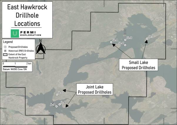
Figure 1: Ongoing and proposed diamond drilling (2026) and historical (1981) drillholes on the East Hawkrock Uranium Property.
FURTHER INFORMATION
Project Geology and Geophysical Summary
Based on interpretations from the 1981 diamond drilling1 and regional data, the property is underlain by flat-lying Athabasca Group sandstone resting on much older Aphebian basement rocks, with the contact between the two occurring at depths of approximately 170-220m. The sandstone is mainly quartz-rich, with thinner layers of siltstone and clay, and shows signs of later alteration including bleaching, iron staining, local silica hardening, and increased fracturing. Beneath this contact, the basement consists of a varied mix of altered sedimentary rocks, including pelitic and arkosic units, conglomerates, and lesser pegmatite and gneiss. This geology displays a palaeoweathered zone at the unconformity, a feature which is inferred to be critical in the formation of deposits elsewhere2.
Hydrogeochemical results from the 1981 drilling programme show that radon and methane gases were locally elevated in groundwater near the unconformity and along interpreted structural zones, particularly in the Small Lake area to the north of the Central Target Area and the proposed holes SL-B and SL-C, with weaker and more limited responses at Joint Lake Target Area. Elevated radon suggests that radon gas is moving upward through nearby fractures or faults, as radon breaks down quickly and cannot travel far from its source. Methane was also detected in some samples and may be generated by graphitic or carbon-rich basement rocks, which can produce methane under low-oxygen conditions. Together, the distribution of these gases indicates active pathways for fluid movement, especially near Small Lake, where structures may link the basement rocks to the overlying sandstone. The locations of these drillholes are shown in Figure 1, and the rationale behind the drill targeting is presented in Table 1, below.
Table 1: Summary of Drillhole Geology, Geophysical Setting, Radon Response and Exploration Rationale
|
Area |
DDH |
Target Geology |
Geophysical Setting |
Radon Response |
Exploration Rationale |
|
Joint Lake |
JL-A |
Graphitic pelitic rocks; intensely deformed fold structure |
Fold hinge zone; structural complexity |
Weak but coherent 350 m trend; max 197.8 pCi/L |
Drill north to intersect mineralised graphitic units at ~200m depth |
|
JL-B |
|||||
|
JL-C |
Structurally complex corridor; graphitic units implied |
Combined EM anomaly and structural complexity |
Elevated radon trend along strike |
Test EM conductor within structurally complicated corridor |
|
|
Small Lake |
SL-A |
Graphitic/conductive corridor |
Magnetic low coincident with conductive trend |
Strongly anomalous radon-in-water; up to 473 pCi/L |
Test coincident magnetic low and conductor with elevated radon |
|
SL-B |
Graphitic units |
Coincident gravity low and a magnetic low; may represent a principal structural corridor |
Within anomalous radon area |
Test structurally focused graphitic unit in gravity/mag low setting |
|
|
SL-C |
Graphitic units; possible deeper-seated source |
Gravity high interpreted as deeper source; implied structural control |
Outside radon sampling grid |
Test deeper gravity source and structural control |
|
|
SL-D |
Basement EM target in a structurally complex zone |
Strong basement EM response; this may suggest multiple linear structural trends |
Elevated radon 122 pCi/L |
Test EM anomaly within a complex structural framework |
GEOPHYSICAL SURVEY METHODS AND DETAILS
Geophysical Surveys - Summary
Three geophysical surveys across the whole of the property were commissioned to support the drilling on East Hawkrock , alongside the in situ radon gas sampling, for which the results have been processed and are presented below:
Ø Xcite Electromagnetic and Magnetic Airborne Survey.
Ø FALCON® Airborne Gravity Gradiometry and Magnetic Survey.
Ø GEOTECH VTEM™ (Versatile Time-Domain Electromagnetic) Survey.
These complementary methods have been instrumental in defining drilling targets and improving the Company's understanding of the East Hawkrock prior to the initiation of this drilling programme.
Xcite Electromagnetic Airborne Survey
The survey was flown using the 30 Hz Xcite™ TDEM system, towed by an AS350B3 helicopter platform, and collected time-domain electromagnetic data. The survey had a line spacing of 75m and tie line spacing of 1,000m and was flown between 30 and 50m above ground level. The survey contractor and consultant team, NRG and Axiom, completed an initial inversion, with further processing by Resource Potentials and GeofizX Geophysical Consulting.
FALCON® Airborne Gravity Gradiometry and Magnetic Survey
An Airborne Gravity Gradiometry Gravity Survey has been carried out over the property to give high-resolution gravity data, alongside magnetic data. The combined survey data has been processed by GeofizX Geophysical Consulting ("GeofizX") to provide a 3D workspace facilitating effective drill planning.
GEOTECH VTEM™ Survey
Following review of the Xcite Electromagnetic Airborne Survey, further clarity on the depth and morphology of the conductive units was required. As such, GEOTECH were commissioned to complete a 321.92 line-km survey, flown with a line spacing of 100m and tie line spacing of 1,000m at an elevation of between 50 and 60m. This survey was completed in late January 2026. This survey was commissioned to improve the Company's understanding of the properties' conductivity (and resistivity) to help delineate drill targets.
GEOPHYSICAL SURVEYS RESULTS
Drill targets for East Hawkrock have been derived from a comprehensive review of multiple geophysical datasets. This methodology focuses on identifying areas of intense fracturing and faulting with coincident conducive anomalies that serve as potential conduits for uranium-bearing fluids. Key indicators used to refine these targets include:
Ø Magnetic Data: Processed to identify magnetic lows associated with prospective pelitic (+/- graphite +/- sulphides) geology.
Ø Gravity Data: Utilised to map potential alteration halos and vertical structural architecture.
Ø Structural Integration: Combining electromagnetic (EM) conductors with gravity/magnetic contrasts to define high-priority "intersections" rather than simple linear trends.
This integrated approach accounts for the variable nature of Athabasca-style uranium mineralisation, using the complementary methods outlined above, and industry and academic work on the methods and in the region 3,4,5,6. The inversion and further post-processing of the surveyed data from East Hawkrock has been carried out by Resource Potentials and GeofizX, with additional input from Professor Irvine Annesley, Fermi's Technical Consultant.
For operational reasons, the programme as currently planned includes five lake ice-based drillholes and two land-based drillhole across two target areas; the Joint Lake and Small Lake Areas. This initial drilling phase remains iterative; results will be integrated with existing geophysical and geological models to refine and generate additional targets. As our understanding of the property's structural framework and potential mineralisation evolves, the programme will be systematically expanded to test new high-priority anomalies.
Joint Lake Area
The Joint Lake Area is interpreted to be situated on the southern limb of a fold structure that has deformed inferred graphitic metasedimentary lithologies within the underlying basement. These inferred graphitic units are interpreted to have been folded and structurally transposed during regional deformation events.
Such a structural setting is considered favourable for unconformity-related uranium systems in the Athabasca Basin. Folded rock layers can create natural zones of weakness, especially where graphitic rocks behave differently from the stronger rocks around them. These contrasts make the rocks more likely to fracture and deform. Later movement along these weakened zones can create faults and small openings in the rock. These features act as pathways that allow mineralising fluids to circulate and concentrate uranium, increasing the potential for deposit formation.
An additional target area has been identified north of Joint Lake. This area is characterised by pronounced magnetic and gravity anomalies interpreted to reflect relatively competent and/or dense basement lithologies (e.g., granitoid or mafic intrusive bodies). These geophysical highs are intersected by conductive lithologies interpreted to represent graphitic or sulphide-bearing structural zones. Figure 2, below, gives a 3D inversion with the proposed drillholes.
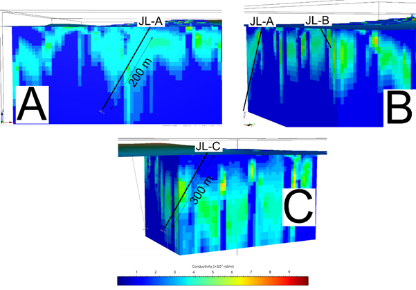
Figure 2: Cross-section slices through the Inversion Model of GEOTECH Electromagnetic survey data. A: Looking to the East, featuring Hole JL-A, note significant structural complexity (folded conductive units). B: looking to the south west, note: JL-B terminated within the model. JL-C targeting the limb of a folded conductor.
Small Lake Area
On Small Lake, three target areas have been delineated from the geophysical surveys and review, a western, central and eastern target area, these drilling locations are targeting areas of anomalous conductivity (graphitic pelite) and complicated structural geology.
The Western Target Area, is characterised by a magnetic low coincident with a conductive trend that passes through the target zone. The hole is currently designed as a vertical drillhole, although final the hole's final declination is depending on further analysis and the results of drilling elsewhere.
In the Central Target Area, the geology is interpreted to be a structurally complex convergence zone characterised by the intersection of multiple structural trends, interpreted to comprise at least three to four distinct orientations, together with a major long-lived east-west-trending shear zone that traverses the area. Two main targets are present in this area, one, a coincident gravity low and magnetic low and lies along a principal structural corridor, and another, situated within a gravity high, interpreted to reflect a deeper-seated source. Finally, within the Eastern Target Area, a further area of strong basement electromagnetic response located along the edge of a gravity high and within an area interpreted to exhibit complex structural geology. Figure 3, below, shows cross-section slices through the 3D inversion model with the proposed holes.
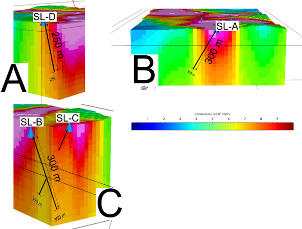
Figure 3: Cross-section slices through the Inversion Model of GEOTECH Electromagnetic survey data. A: Looking to the south west, featuring Hole SL-D. B: looking to the east, showing a cross section of the main conductive target area. C: looking to the south, with the two proposed holes (SL-B and SL-C) crossing a conductive zone, within an area of structural complexity.
RADON IN WATER SAMPLING
While an understanding of the geophysical nature of the property is critical in determining drill targets, the Fermi Technical Team wished to use a secondary, surface method to complement the geophysical method. Previous work1 had indicated that radon enrichments were recorded within one hole in Small Lake.
Radon is a naturally occurring noble gas generated during the radiogenic decay of uranium via radium. Because Rn-222 is a direct decay product of uranium, elevated radon concentrations measured at the surface or in lake waters provide a direct indication of uranium present at depth. Radon's short half-life (3.8 days) limits its migration distance, meaning detected anomalies must be sourced from nearby uranium mineralisation or active structural pathways, making radon a focused and reliable exploration vector rather than a diffuse regional signal. The exploration was conducted and managed, by Senior Team Members of RadonEx, of St. Lazare, Quebec.
To evaluate radon levels across the East Hawkrock property, three target areas were selected, each coincident with historically identified electromagnetic conductors interpreted to represent prospective structural or permeability features associated with unconformity-related uranium mineralisation elsewhere in the Athabasca Basin. The radon survey was completed during the winter field season of 2025, prior to the availability of modern airborne geophysical datasets. Accordingly, historical geophysical data 1,7 were used to guide survey design, with results intended to be integrated with forthcoming high-resolution geophysical surveys. The programme comprised three principal target areas subdivided into six sampling grids, totalling 463 radon samples.
Radon sampling over frozen lakes was conducted by augering holes through the ice at regular intervals along predetermined grids, followed by measuring water depth with a digital sonar to ensure consistent sampling. Water samples were collected approximately one metre above the lake bottom using a submersible sampler, transferred into 200ml syringes, and sealed in airtight glass jars at camp. Electrets with recorded initial voltages were mounted in sealed radon test units and suspended within each jar for a 48-hour exposure period, after which final voltages were measured. The change in electret voltage was used to calculate the radon concentration of each water sample. Radon results are "adjusted" against a daily sample site to minimise the effect of outside influences, and as such, in this release are reported as "Adjusted Radon in Water results".
As the two lakes surveyed, Joint Lake and Small Lake, may have different hydrological conditions, values are reported separately for each. The radon sampling was conducted before the modern (2025/2026) geophysical survey in early spring 2025 and was planned using historical geophysical data. As such, the extent of the radon sampling is distinct from the areas of interest outlined in the geophysical section of this announcement.
Small Lake
Small Lake, the larger of the two lakes surveyed and located near the centre of the property, returned adjusted radon-in-water values ranging from 41.7 to 1,207.8 pCi/L, with a mean of 77.1 pCi/L. The highest value (1,207.8 pCi/L) represents a pronounced outlier within the dataset and indicates a highly localised zone of significant radon enrichment, albeit one without significant geophysical anomalism. Elsewhere on the north of Small Lake, four principal linear trends, each extending up to approximately 400m, are evident, together with several isolated elevated responses. A secondary area, in the south of Small Lake is characterised by generally lower radon concentrations, with a maximum value of 153.5 pCi/L, multiple trends can be observed. Figure 4, below shows the sample locations over major structural features.
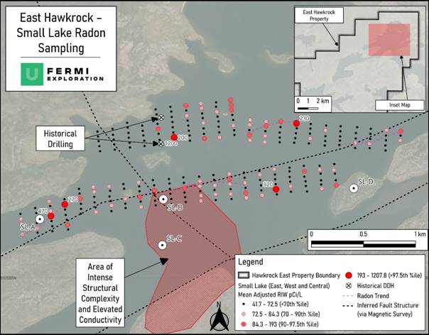
Figure 4: Small Lake Radon Results, and Simplified Structural Geology
Joint Lake
Joint Lake, located in the southwestern part of the East Hawkrock licence area, yielded adjusted radon-in-water values ranging from 58.6 to 483.2 pCi/L, with a mean of 91.8 pCi/L. The most elevated responses occur within the northern grid of Joint Lake, directly opposite the area of elevated radon concentrations identified in the southwestern part of Small Lake. Additional elevated values are present in the southeastern portion of the lake, where a maximum value of 197.8 pCi/L occurs within an otherwise lower-background population. These results define a weak but coherent radon enrichment trend extending approximately 350m. Figure 5, below shows the sample locations over major structural features.
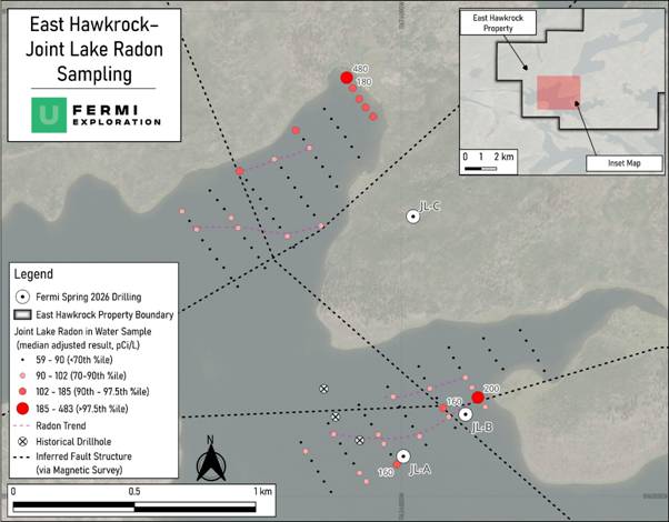
Figure 5: Joint Lake Radon Results, and Simplified Structural Geology
Radon Results in Comparison to Other Projects
Radon in water has been used across the Athabasca Basin, with particular success in the southwest of the Basin, where lakes cover portions of both the Triple R and secondary occurrences close to the Arrow uranium deposits.
A significant radon anomaly was detected 3.7 km to the north of the world-class Arrow Deposit, which hosts Measured and Indicated Resources of 3.75 Mt 3.1% U₃O₈ (~257 Mlb) and Inferred Resources of 4.40 Mt at 0.83% U₃O₈ (80.7 Mlb8); The coincident "Bow" uranium target was subsequently discovered as a result of testing9 this highly anomalous radon signature of 36.0 pCi/L (against a background of around 0.6 pCi/L), situated 80 m south of drilled off-scale radioactivity10. In comparison, the results from East Hawkrock are many magnitudes above those from the Bow target area. The East Hawkrock property appears to possess generally elevated radon-in-water results, although the precise mechanism behind this remains unknown at this time.
Radon-in-water and radon-in-sediment surveys were also carried out in 2013 and 2014 over Patterson Lake, with results showing an ENE-WSW trend in radon-in-water data that is coincident with the strong VTEM conductor and the Triple R deposit11. Locally to Triple R (Indicated Mineral Resources of 2.29 Mt grading 1.58 % U₃O₈ (79.6 M lb) and Inferred Mineral Resources of 0.90 Mt at 1.30 % U₃O₈ (25.9 M lb)), historical regional sampling also includes a 2008 radon-in-water result of 162 pCi/L on the Saloon trend, with the highest recorded radon value directly above the Triple R deposit of 14.4 pCi/L, this result was inferred to indicate anomalous radon dispersion adjacent to known mineralisation12.
DRILL TARGETS
Drilling targets have been defined on the property though combined review of the magnetic, gravity and electromagnetic surveys, combined with historical drilling data and the spring 2025 radon sampling programme. These targets, and the rationale behind them are presented in Table 1.
Faults and structurally complex zones-identified through geophysical surveys-can therefore account for radon anomalies that are offset from mineralisation. In this context, the geophysical analysis often provides the primary structural framework for the project, carrying much more weight in the final interpretation than the radon data alone. Understanding these structural pathways helps explain the observed patterns and supports confident drill targeting by ensuring that both the geochemical signals and the underlying physical architecture are accounted for.
Joint Lake
Two drillholes are planned on the frozen lake itself, with the preliminary notations of JL-A and JL-B, these drillholes are on the eastern edge of a fold structure within which prospective geology rocks are interpreted to have been subject to intense structural deformation. Radon sampling in this area yielded a weak but coherent radon enrichment trend extending approximately 350 m, with a maximum value of 197.8 pCi/L. Drillholes JL-A and JL-B are planned to be drilled to the north, to intersect the graphitic pelitic rocks and uranium mineralisation contained within at a depth of around 200m.
An additional land hole, JL-C is planned to target the combined electromagnetic anomaly and complicated structural geology to the north of Joint Lake, a trend of elevated radon results is present along trend of this drillhole.
Small Lake
Despite the highly anomalous radon results in the north of the lake, the geophysical response in this area appears muted, and as such, the radon detected in this area is interpreted to have been transported along fault structure from a nearby source.
In the western target area, the proposed drillhole SL-A is designed to test a magnetic low along a conductive trend, in this area radon-in-water results are anomalous and locally very elevated, reaching up to 473 pCi/L.
In the central target area the structurally complex geology requires two different approaches, both holes are targeting graphitic units, however, one hole; SL-B is positioned within a coincident gravity low and magnetic low and lies along a principal structural corridor. While the second hole, SL-C is situated within a gravity high, interpreted to reflect a deeper-seated source and may be related to significant structural control. The proposed location of SL-C is outside of the radon sampling gird.
In the eastern Target Area to test further complex structural geology and an area of strong basement electromagnetic response, SL-D will be drilled from a small island. In this area a strongly elevated radon result of 122 pCi/L is present, with multiple linear trends present nearby.
NEXT STEPS
The maiden drill programme at the East Hawkrock Property is actively ongoing and is expected to run continuously until mid-April. This campaign will operate concurrently with the 2,100m drill programme targeting the S-Zone at the Badger Lake Property that commenced on 2nd March 2026.
The East Hawkrock drilling programme remains under continuous assessment; future analysis will integrate, encompass, and interpret the results of the drilled geology and geophysics, alongside the radon data identified in this announcement.
GLOSSARY
|
Term |
Definition |
|
²⁰⁶Pb/²⁰⁴Pb Lead Isotopes |
A measure of the ratio of uranium-derived lead (known as "radiogenic lead" ²⁰⁶Pb) to non-radiogenic "primordial" lead (²⁰⁴Pb). High ratios may suggest uranium mineralisation. |
|
²⁰⁷Pb/²⁰⁶Pb Lead Isotopes |
Lower ²⁰⁷Pb/²⁰⁶Pb ratios (typically around 0.15-0.20 in Athabasca-style systems) are diagnostic of radiogenic lead derived from uranium minerals. |
|
Adjusted Radon in Water |
Radon measurements corrected against a daily control site to remove the influence of weather or hydrological conditions. |
|
Airborne Gravity Gradiometry |
A high-resolution geophysical survey method flown by aircraft to measure variations in the Earth's gravity, which helps map vertical structural architecture and potential alteration halos. |
|
Alteration |
A change in the mineral composition and texture of a rock due to hydrothermal fluids, heat, pressure, or other geological processes. It often occurs near ore deposits and can serve as an exploration guide. |
|
Athabasca Group Sandstone |
Quartz-rich sedimentary rock that overlies the older basement; at East Hawkrock, it is roughly 170-220 m thick. |
|
Background Levels |
The standard, low level of minerals or radiation naturally present in an area; used to identify what qualifies as an "anomaly". |
|
Basement Rocks |
Older crystalline rocks (granite, gneiss, etc.) that lie beneath younger sedimentary layers. In the Athabasca Basin, uranium mineralisation often forms at or just below this contact. |
|
Chlorite Alteration |
A type of chemical alteration in which chlorite (a green, iron-rich mineral) forms in response to hydrothermal fluids. Often found near uranium deposits as part of the alteration halo. |
|
Conductive Corridor |
A 6 km-long linear zone that conducts electricity; these typically represent graphitic units that facilitate mineralising fluid flow. |
|
Electret |
A device with a recorded initial voltage that is suspended within a sealed sampling jar. The change in its voltage over a set exposure period is used to calculate the concentration of radon gas within a water sample. |
|
Electromagnetic (EM) Conductor / Anomaly |
A geological feature that conducts electricity and/or magnetic permeability. In the Athabasca Basin, these are often interpreted as graphitic or sulphide-bearing structural zones that can serve as permeability features associated with uranium mineralisation. |
|
FALCON® Gravity |
High-resolution survey measuring variations in Earth's density to map the 3D "vertical architecture" of fault systems. |
|
Graphitic Units / Corridor |
Rock layers containing graphite that often behave differently from surrounding stronger rocks, creating natural zones of weakness. These contrasts make the rocks more likely to fracture and deform, acting as pathways that allow mineralising fluids to circulate. |
|
Gravity Low / High |
Distinct anomalies identified in gravity data. Gravity lows may indicate potential alteration and structural preparation, whilst gravity highs are often interpreted to reflect deeper-seated structural sources or denser, more competent basement lithologies. |
|
Hydrothermal Alteration |
Chemical changes in rock caused by hot, mineral-rich fluids; indicators include bleaching, iron staining, and silica hardening. |
|
Magnetic Low |
Areas of reduced magnetic response identified in processed magnetic data, which are often associated with prospective pelitic geology or the destruction of magnetic minerals through hydrothermal alteration. |
|
Magnetic/Gravity Inversion |
A mathematical process converting 2D survey data into a 3D model to visualise underground structures before drilling. |
|
Metapelite |
A metamorphosed fine-grained sedimentary rock originally rich in clay (i.e., a pelite). Commonly includes minerals like garnet, biotite, and sillimanite, depending on metamorphic grade. |
|
NQ Drilling |
A standard diamond drilling specification that extracts a continuous cylinder of rock core (approximately 47.6 millimetres in diameter), allowing geologists to physically examine the subsurface stratigraphy and structure. |
|
pCi/L (Picocuries per litre) |
A standard unit of measurement used to quantify the concentration of radioactivity, specifically utilised in this release to report the levels of radon gas detected in water samples. |
|
Radiogenic Decay |
The natural process where unstable elements like uranium break down into radium and eventually radon gas. |
|
Radon Anomalism |
Radon levels significantly higher than "background" levels; used as a "smoke signal" for uranium decay at depth. |
|
Radon-in-water |
An exploration technique measuring radon, a naturally occurring noble gas generated during the radiogenic decay of uranium. Because it has a short half-life of 3.8 days, elevated concentrations in surface or lake waters provide a direct indication of nearby uranium mineralisation or active structural pathways at depth. |
|
Short-Wave Infrared (SWIR) Spectroscopy |
A mineral identification method based on the infrared absorption spectra of minerals. Useful for detecting clays and alteration minerals associated with hydrothermal systems. |
|
Structural Offsets & Flexures |
Breaks or bends in geological features; these "disruptions" create the physical space required for uranium deposition. |
|
Structurally Complex |
Describes a rock or geological area that has undergone multiple phases of deformation, resulting in a mix of folds, faults, shears, and fractures. Such areas can host mineralisation due to enhanced fluid flow pathways. |
|
Unconformity |
The critical boundary where younger sandstone meets older basement rock; a primary site for uranium concentration. |
|
VTEM™ / TDEM |
Airborne surveys that use electromagnetic pulses to map the depth and shape of conductive underground units. |
REFERENCES
|
1 |
W.G. Wahl Limited (1981) Report on diamond drilling and associated geophysical and hydrogeochemical studies, Black Lake Project (Small-Joint Lake), Saskatchewan, Canada. Unpublished technical report prepared for Saskatchewan Mining Development Corporation (SMDC), 1981. 74I16-0020_1981
|
|
2 |
Qiu, H., Lin, H. & Yang, J. (2023). Effects of Paleoregolith and Fault Offset on the Formation of Unconformity-Type Uranium Deposits. Minerals, 13(11), 1381
|
|
3 |
Powell, B., Wood, G. and Bzdel, L. (2007) 'Advances in Geophysical Exploration for Uranium Deposits', in Milkereit, B. (ed.) Proceedings of Exploration 07: Fifth Decennial International Conference on Mineral Exploration. Toronto: CAMIRO, pp. 771-790.
|
|
4 |
Vallée, M.A., Moussaoui, M. and Khan, K. (2024) 'Case Studies of Magnetic and Electromagnetic Techniques Covering the Last Fifteen Years', Minerals, 14(12), p. 1286. Available at: https://doi.org/10.3390/min14121286
|
|
5 |
Legault, J.M., Wood, G., Izarra, C., Keller, C., Prikhodko, A. and O'Dowd, C. (2018) Comparing VTEM Time-Domain EM and ZTEM Natural Field Airborne EM Survey Results over the McArthur River Unconformity Uranium Project. Presented at the SEG International Exposition and 88th Annual Meeting, Anaheim, California.
|
|
6 |
Matthews R., Koch R. and Leppin M. 1997. Advances in integrated exploration for unconformity uranium deposits in western Canada. In: Proceedings of Exploration 97: Fourth Decennial International Conference on Mineral Exploration (ed. A.G. Gubins), pp. 993-1002. Available at: http://www.exploration07.com/pdfs/Expl97/12_03___.pdf
|
|
7 |
Geotech Ltd. (2008) Report on a helicopter-borne versatile time domain electromagnetic (VTEM) geophysical survey, Athabasca Property, Northern Saskatchewan, Canada. Aurora, ON: Geotech Ltd. Prepared for Magnum Uranium Corp., Project 7076 June 2008. 74I16-0030
|
|
8 |
NexGen Energy Ltd. (2021) Arrow Deposit, Rook I Project, Saskatchewan, NI 43-101 Technical Report on Feasibility Study, effective 10 March 2021.
|
|
9 |
https://investingnews.com/files/2015/04/NexGen-PR-April-13-2015-BOW.pdf
|
|
10 |
NexGen Energy Ltd. (2015) Management's Discussion and Analysis: Three Months Ended March 31, 2015. Vancouver: NexGen Energy Ltd.. Available at: https://s28.q4cdn.com/891672792/files/doc_financials/2015/q1/1Q15-MDA.pdf
|
|
11 |
Fission Uranium Corp. (2023) Feasibility Study, NI 43-101 Technical Report, PLS Property, Saskatchewan, Canada, effective 17 January 2023. |
|
12 |
Ross, D.A., 2015. Technical Report on the Patterson Lake South Property, Northern Saskatchewan, Canada: NI 43-101 Report. Roscoe Postle Associates Inc. Prepared for Fission Uranium Corp., 12 February 2015. Available at: https://digigeodatareports.b-cdn.net/28.pdf |
QUALIFIED PERSON STATEMENT
The technical information contained in this disclosure has been read and approved by Mr Nick O'Reilly (MSc, DIC, MIMMM QMR, MAusIMM, FGS), who is a qualified geologist and acts as the Qualified Person under the AIM Rules - Note for Mining and Oil & Gas Companies. Mr O'Reilly is a Principal consultant working for Mining Analyst Consulting Ltd which has been retained by Power Metal Resources PLC to provide technical support.
For further information please visit https://www.powermetalresources.com/ or contact:
|
Power Metal Resources plc |
|
|
|
|
Sean Wade (Chief Executive Officer) |
+44 (0) 20 3778 1396 |
|
|
|
|
|
|
|
|
SP Angel Corporate Finance LLP (Nomad and Joint Broker) |
|
|
|
|
Ewan Leggat/Jen Clarke |
+44 (0) 20 3470 0470 |
|
|
|
|
|
|
|
|
Tamesis Partners LLP (Joint Broker) |
|
|
|
|
Richard Greenfield/Charlie Bendon |
+44 (0) 20 3882 2868 |
|
|
|
|
|
|
|
|
BlytheRay (PR Advisors) |
|
|
|
|
Rachael Brooks/Alastair Roberts |
+44 (0) 20 7138 3204
|
|
|
|
|
|
||
NOTES TO EDITORS
Power Metal Resources plc - Background
Power Metal Resources plc (AIM: POW, OTCQB: POWMF) is a London-listed metals exploration company which finances and manages global resource projects and is seeking large scale metal discoveries.
The Company has a principal focus on opportunities offering district scale potential across a global portfolio including precious, base and strategic metal exploration in North America, Africa, Saudi Arabia, Oman and Australia.
Project interests range from early-stage greenfield exploration to later-stage prospects currently subject to drill programmes.
Power Metal will develop projects internally or through strategic joint ventures until a project becomes ready for disposal through outright sale or separate listing on a recognised stock exchange thereby crystallising the value generated from our internal exploration and development work.
Value generated through disposals will be deployed internally to drive the Company's growth or may be returned to shareholders through share buy backs, dividends or in-specie distributions of assets.
RNS may use your IP address to confirm compliance with the terms and conditions, to analyse how you engage with the information contained in this communication, and to share such analysis on an anonymised basis with others as part of our commercial services. For further information about how RNS and the London Stock Exchange use the personal data you provide us, please see our Privacy Policy.


Latest directors dealings
- 4 hours ago Unilever
- 7 hours ago Sainsbury (J)
- 7 hours ago Great Portland Estates
- 8 hours ago XPS Pensions Group
- 8 hours ago Diageo