
New Copper-Silver-Gold Project, Nevada
Summary by AI BETAClose X

SUNRISE RESOURCES PLC
("Sunrise" or the "Company")
20 July 2026
New Copper-Silver-Gold Project, Nevada
Drill intersections include 50m grading 0.73% copper, 31g/t silver and 0.2g/t gold from surface
Company surface samples assay up to 198 g/t silver, 0.13% copper
and 0.3g/t gold
The Company is pleased to announce that it has established a new copper-silver-gold project in Nevada, USA, which it has named the Lake Copper-Silver-Gold Project after its location in the Lake Mining District in Churchill County, Nevada, USA.
Highlights:
· Project located at south-west end of the prospective Humboldt Range which is host to numerous large-scale current, planned and past producing gold and silver deposits (see accompanying Location Plan).
· Company has secured a low entry-cost lease &option to purchase agreement over a mining claim covering copper-silver-gold mineralisation originally discovered in 1985 by Utah International (a subsidiary of BHP) and has staked a further ten adjacent mining claims.
· Utah International drill hole MH-4 intersected 50m from surface grading 0.73% copper, 31g/t silver (1oz/t) and 0.2g/t gold in skarn-type mineralisation.
· Copper-silver mineralisation occurs from surface. Company's recent surface sampling from a due diligence field visit gave results up to 198g/t silver (6.4oz/t) 0.13% copper and 0.3g/t gold in sulphide rich sample.
· Mineralisation occurs with a 450m long arsenic and antimony anomaly coincident with mineralised area within a regional low-level gold-in-rock anomaly that extends 1.5 km through the claim block.
· Targeting intrusion related copper-precious metals deposit.
Commenting today, Executive Chairman, Patrick Cheetham said "This exciting acquisition follows on from our recently announced decision to focus on precious and base metal projects and I am delighted to be announcing our first copper exploration project in Nevada. Copper is a critical metal in the energy transition and has seen its price increase significantly in the past few years. Nevada is host to a number of large copper mining and development projects.
"With historical drill intersections of economically significant grades, the target is well-defined with a number of drill holes intersecting thick zones of skarn mineralisation from surface, a style of mineralisation that can host significant copper, silver and gold deposits and which, importantly, can also provide a vector to porphyry copper deposits."
"Projects of this calibre are hard to come by and the acquisition results from a long-standing programme of archival research and field reconnaissance. The path forward for this project is clear with the next steps already defined to include geophysical surveying and follow up drilling as resources allow."
Further information:
|
Sunrise Resources plc Patrick Cheetham, Executive Chairman |
Tel: +44 (0)1625 838 884 |
|
Beaumont Cornish Limited Nominated Adviser James Biddle/Roland Cornish |
Tel: +44 (0)207 628 3396 |
|
AlbR Capital Limited Broker Lucy Williams/Duncan Vasey
|
Tel: +44 (0)207 469 0930 |
Detailed Information, Lake Copper-Silver-Gold Project
Location & Access
The Lake Project is located on the south side of the Mopung Hills which form the southwest end of the Humboldt Mountain Range in Churchill County, Nevada.
It is located 98km east-northeast of Reno and access is excellent from Interstate Highway I-80 and Highway 95 and a series of unsealed roads and tracks to the project area.
Past Exploration
The only record of previous exploration in the target area is from the mid-1980s when Utah International ("Utah"), a US subsidiary of mining giant BHP, held a large claim block.
Originally, Utah targeted the discovery of Carlin-type gold mineralisation. Exploration initially comprised detailed semi-regional mapping and rock chip sampling. Utah subsequently completed extensive claim staking and two separate phases of drilling. Fourteen shallow (mainly <100m deep and maximum 150m deep) holes were drilled in the Company's claim area.
Geology & Mineralisation
The youngest rocks in the area are a series of Tertiary-age volcanics that overlie Jurassic age gabbro and co-magmatic basalts, the gabbro being a part of the regionally extensive Humboldt Lopolith. The gabbro sits above a thrust fault contact with brecciated middle Jurassic age carbonates deposited in a shelf environment (black limestone, quartz arenites and calcarenites) and a lower Jurassic basinal sequence (thin bedded carbonaceous shaley limestone). Elsewhere in the Humboldt Range this thrust fault is referred to as the Wildhorse Thrust.
The south end of the Humboldt Range is a horst-block bounded by major northeast trending major fault zones. In the Company's claim area a series of east-northeast trending high angle structural features mark a structural corridor parallel to the range bounding faults some several hundred metres wide where the shelf and basin carbonate sequences and Tertiary volcanics are hydrothermally silicified and decarbonatised and rock chip samples are anomalous in gold (0.1-0.55g/t) antimony (32 to 4,300ppm) and arsenic (25 to 750ppm), all classical indicators for Carlin-type gold deposits.
Utah postulated that reactive limestones beneath the Wildhorse Thrust could be host to Carlin-type gold deposits and this was the target for Utah's first wide-spaced drill testing. This remains an attractive target at depth.
A number of Utah's first phase of drill holes in the claim area intersected anomalous gold, arsenic and silver with gold values up 0.1g/t gold, as shown in the table below, but most notably hole MH-4 intersected a wide interval of mineralised skarn of economically significant grade:
MH-4: 50m grading 0.73% copper, 31g/t silver (1 oz/t) and 0.3g/t gold from surface.
A second phase of 7 shallow vertical drill holes made a number of further mineralised intersections with Hole MH-18 being of particular significance intersecting high values of silver and with skarn mineralisation continuing at the bottom of the hole.
Company Field Visit & Exploration Plans
As part of its due diligence on the lease-option agreement, a field visit was made by the Company's consulting geologist, Ivan Johnson. The mineralisation intersected from surface in Utah hole MH-4 was found to be visible in a small prospecting mine shaft where sub-vertical ribs of massive silica in upper plate calc-arenites border quartz-garnet skarn with visible copper stain and up to 20% pyrite.
A surface sample from the wall of this prospecting shaft assayed 198g/t silver, 0.13% copper and 0.3g/t gold.
The geology of the project area is complex with multiple phases of faulting and mineralisation having taken place over a long period of geological time. The Company is primarily targeting an intrusive related copper-precious metals deposit although Carlin-type and epithermal mineralisation are also valid targets. Drilling to date has been shallow but has nevertheless made drill intersections of economic significance. The copper-silver silicified skarn mineralisation is sulphide-rich from surface and so potentially amenable to geophysical targeting prior to drilling.
Lease/Option Terms
The Company has entered into an agreement with Mr. Rolf Thiele ("Lessor) that grants to the Company a mining lease over, and an option to purchase, the key Lake Project mining claim (the "Claim") where Utah's Phase 2 drilling was carried out (see accompanying Figure 2). The following are the principal terms of the agreement:
· 7-year lease/option term which can be extended at Company's option for two successive 7-year terms (21 years in total).
· Nominal payment on signing Agreement - US$100.
· Annual payments to the Lessor starting at US$5,000 at the end of Year 1 rising by US$2,500 per year up to a maximum of $20,000 per year by the end of year 7 and in subsequent years. Payments can be offset against future royalty payment obligations.
· Royalty payable to the Lessor of 2% of the Net Smelter Return ("NSR"). The NSR Royalty may be bought back for the sum of US$500,000 at any time.
· Company has the option to purchase the Lake Project Claim at any time during the lease period or extended lease period on payment of $150,000.
· Company can proceed to mining under the 21-year lease agreement without purchasing the underlying mining claim.
· Company can withdraw from the agreement at any time.
· No fixed expenditure commitments.
The Lessor has not incurred significant expenditure on the Claim other than to maintain the Claim in good standing.
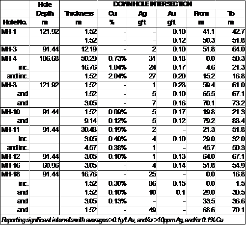
Table of significant drill intersections, Utah International 1985
Glossary
Carlin-type: a type of disseminate gold deposit hosted in silicified and decarbonatised silty carbonaceous limestones where gold is intimately associated with pyrite (iron sulphide, arsenopyrite (an arsenic sulphide) and stibnite (an antimony sulphide) and barite. Named after the Carlin deposit in Nevada. Carlin-type deposits are particularly found in Nevada and include some of the largest gold deposits in the World.
Horst: a raised fault block bounded by normal faults.
Lopolith: igneous intrusion associated with a structural basin, with contacts that are parallel to the bedding of the enclosing rocks. In an ideal example, the enclosing sediments above and below the lopolith dip inward from all sides towards the centre, so that the lopolith is concave upwards. Lopoliths, which can be several miles to several hundred miles in diameter, with thicknesses up to several thousand feet, are some of the largest igneous intrusions known.
Mullock: broken rock discarded in mining operations.
Skarn: rock formed through the replacement of carbonate-bearing rocks during regional or contact metamorphism and metasomatism. This process involves the interaction of hydrothermal fluids with the precursor rock which can be of either igneous or sedimentary origin. Skarns are typically rich in calcium, magnesium, iron, manganese, and aluminum silicate minerals, also known as calc-silicate minerals. Skarns can be host to commercial deposits of copper, lead, zinc, tungsten +/- precious metals.
Thrust: a flat to shallow angled fault structure where compressive lateral movement occurs, often over long distances, juxtaposing plates of rock of different ages and origins.
Units:
g/t: grammes per tonne or parts per million. oz/t: troy ounces per short ton. 1oz/t = 31.1g/t.
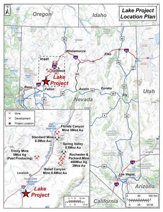
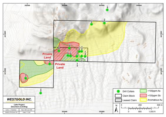
Figure 2. Lake Project Geochemistry & Drilling
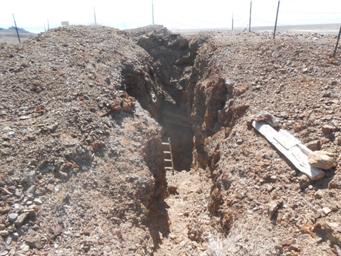
Prospecting shaft in silicified limestone and skarn
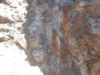
Rib of silicified limestone in contact with skarn
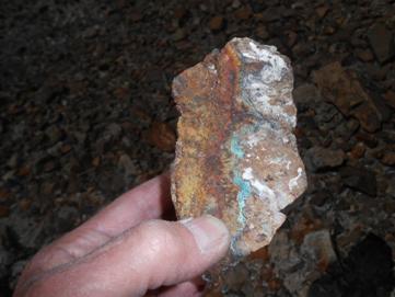
Secondary copper minerals (green) in shaft mullock
Qualified Person Information:
The information in this release has been compiled and reviewed by Mr. Patrick Cheetham (MIMMM, MAusIMM) who is a qualified person for the purposes of the AIM Note for Mining and Oil & Gas Companies. Mr. Cheetham is a Member of the Institute of Materials, Minerals & Mining and also a member of the Australasian Institute of Mining & Metallurgy.
Market Abuse Regulation (MAR) Disclosure
The information contained within this announcement is deemed by the Company to constitute inside information as stipulated under the Market Abuse Regulations (EU) No. 596/2014 which forms part of UK domestic law by virtue of the European Union (Withdrawal) Act 2018 ('MAR'). Upon the publication of this announcement via Regulatory Information Service ('RIS'), this inside information is now considered to be in the public domain.
Nominated Adviser
Beaumont Cornish Limited ("Beaumont Cornish") is the Company's Nominated Adviser and is authorised and regulated by the FCA. Beaumont Cornish's responsibilities as the Company's Nominated Adviser, including a responsibility to advise and guide the Company on its responsibilities under the AIM Rules for Companies and AIM Rules for Nominated Advisers, are owed solely to the London Stock Exchange. Beaumont Cornish is not acting for and will not be responsible to any other persons for providing protections afforded to customers of Beaumont Cornish nor for advising them in relation to the proposed arrangements described in this announcement or any matter referred to in it.
Shares in the Company trade on AIM. EPIC: "SRES".
Website: www.sunriseresourcesplc.com
RNS may use your IP address to confirm compliance with the terms and conditions, to analyse how you engage with the information contained in this communication, and to share such analysis on an anonymised basis with others as part of our commercial services. For further information about how RNS and the London Stock Exchange use the personal data you provide us, please see our Privacy Policy.

Latest directors dealings
- 2 days ago City of London Investment Group
- 2 days ago Kooth
- 2 days ago THG
- 2 days ago Origin Enterprises (CDI)
- 2 days ago Kingfisher