New High Priority Targets Identified at ELN
Summary by AI BETAClose X

NEWS RELEASE 14 MAY 2026
NEW HIGH PRIORITY TUNGSTEN AND ANTIMONY TARGETS IDENTIFIED AT ELEONORE NORTH
HIGHLIGHTS
· New tungsten and antimony targets identified at the Margeries Prospects in East Greenland following the reprocessing of historical airborne hyperspectral data, which has revealed multiple zones of hydrothermal alteration across the licence area
· Multiple walk-up surface anomalies identified along strike and adjacent to the existing high-grade tungsten (W) and antimony (Sb) historical estimates previously identified at North Margeries (Sb-W) and South Margeries (W)
· 2km-long prospectivity anomaly at North Margeries sits adjacent to a major east-west fault structure, with multiple additional anomalies surrounding the South Margeries historical estimate
· Targets were generated by applying modern processing techniques to a heritage dataset acquired from an airborne hyperspectral survey flown in 2000 across the East Greenland Licences
· The 2026 fieldwork will test the new targets and collect bulk samples at North and South Margeries for tungsten and antimony metallurgical sighter test work
· Noa Pluton 2026 fieldwork and other gold (Au) targets across Eleonore North will include field mapping and sampling
· Aim of fieldwork in 2026 is to confirm drill ready targets at both North and South Margeries and Noa Pluton
GreenX Metals Limited (ASX:GRX, LSE:GRX GPW:GRX, Germany-FSE:A3C9JR) (GreenX or the Company) is pleased to announce that the reprocessing of a historical airborne hyperspectral survey has identified multiple new high-priority tungsten, antimony, and gold targets at the Eleonore North Project in the East Greenland (ELN or Eleonore North). The new targets sit along strike and adjacent to the existing high-grade tungsten and antimony historical estimates identified at North and South Margeries, providing the Company with potential walk-up surface targets to test during the planned field season, which is expected to commence in July 2026.
Tungsten and antimony are both listed as critical raw materials by the European Union and the United States, with global supply heavily concentrated in China. The Margeries Prospects host high-grade historical estimates of both metals in a stable Western jurisdiction.
GreenX CEO, Mr Ben Stoikovich, said, "The reprocessing of the historical hyperspectral data has delivered exactly what we hoped for: new walk-up tungsten and antimony targets, generated at minimal cost, sitting right alongside our existing high-grade historical estimates at North and South Margeries. With the 2026 field season only weeks away, our exploration team now has a clear pipeline of priority targets to advance on the ground, further defining and prioritising potential drill targets for future field programs."
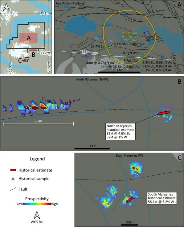
Figure 1: Prospectivity analysis by TheiaX highlights new areas for investigation around Noa Pluton, and North and South Margeries Prospects.
Cautionary statement: The historical estimate in this announcement is not reported in accordance with the JORC Code 2012 (JORC Code). A competent person has not done sufficient work to classify the historical estimate as a mineral resource or ore reserve in accordance with the JORC Code. It is uncertain that following evaluation and/or further exploration work that the historical estimate will be able to be reported as a mineral resource or ore reserve in accordance with the JORC Code.
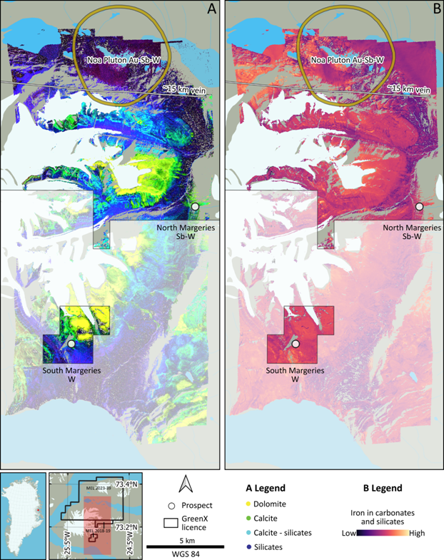
Figure 2: Location of the airborne hyperspectral survey with examples of spectral data products. A: False colour composite illustrating the dominant distribution of four mineral groups. B: Relative abundance of iron in carbonates and silicates.
Survey background and processing
Flown in 2000, the airborne hyperspectral survey was part of "Project HyperGreen". The Geological Survey of Denmark and Greenland (GEUS) commissioned the project, which was financed by Greenland's Bureau of Minerals and Petroleum. Data acquisition was contracted to HyVista Corporation (Australia), which used a HyMap system mounted in a Dornier 228 aircraft. Six flight lines covering 186 line-km produced a survey area with dimensions of approximately 12 km x 25 km. The survey produced a pixel size of 5 m, making it high resolution compared to typical satellite surveys, which range from 15 m to 30 m.
Raw data from the survey has been stored by GEUS and was recently made available to GreenX. Data processing was completed by TheiaX GmbH (TheiaX) in Germany. Processing involved converting the raw data from radiance to reflectance values, orthorectification, mosaicking, spectral index calculations and culminated in a prospectivity analysis.
Results and prospectivity analysis
The prospectivity analysis identified surface anomalies that share spectral patterns observed at the known historical estimate occurrences at North and South Margeries. These prospective areas represent surface anomalies that have the potential to be walk-up discoveries.
At North Margeries (Figure 1B), a 2 km-long prospectivity anomaly sits 3 km west of the historical estimate and adjacent to a large east-west fault structure.
At South Margeries (Figure 1C), multiple prospectivity anomalies surround the Historical Estimate and likely sit in faults that do not appear in the 1:500,000 scale geological maps.
The anomalies were identified by recognising patterns in spectral indexes proximal to the known mineral occurrences, then applying those patterns across the broader licence area. Various spectral index maps were produced during processing. False colour composites can illustrate the dominant distribution of mineral groups (Figure 2A). Two band indexes can separately illustrate the relative abundance of a mineral group or their compositional variation, e.g., abundance of iron ± magnesium silicates or compositional variation of those silicates from iron-rich to magnesium-rich end members. Various one band index maps were produced to show relative abundance, e.g., iron in carbonates and silicates (Figure 2B).
Upcoming Work Programs
On the ground fieldwork at ELN is currently being planned to commence in July 2026. The hyperspectral mineral mapping and prospectivity analysis have provided GreenX with surface targets with the potential for walk-up discoveries. At Noa Pluton, hyperspectral targets likely have structural controls that match the Reduced Intrusion-related Gold (Au) System (RIRGS).
At North and South Margeries, the plan is to collect bulk material for sighter metallurgical test work. The hyperspectral survey has also revealed potential extensions past areas of historical drilling, which are worthy of investigation, and will be used to identify potential drill targets.
The Noa Pluton Sb-Au-W prospect will be evaluated by a RIRGS specialist. Fieldwork to evaluate the RIRGS potential will likely involve mapping and sampling to identify future drill targets.
Licence reduction
Following a technical review and in accordance with Greenland's mining law, the northern portion of MEL 2023-39 has been relinquished. This has reduced the licence area from 1,190 km2 to 494 km2 and, as a result, decreased the minimal annual exploration obligations for MEL 2023-39.
ENQUIRIES
|
Ben Stoikovich Chief Executive Officer
+44 207 478 3900 |
Kazimierz Chojna Investor Relations - Poland
Kim Eckhof Investor Relations - UK / Germany |
Competent Persons Statement - Exploration results
Information in this announcement that relates to Exploration Results for the hyperspectral survey is based on and fairly represents, information and supporting documentation compiled by Mr Joel Burkin, a Competent Person who is a member of the Australian Institute of Geoscientists. Mr Burkin is a consultant engaged by GreenX and is a holder of unlisted options in the Company. Mr Burkin has sufficient experience that is relevant to the style of mineralisation and type of deposit under consideration and to the activity being undertaken, to qualify as a Competent Person as defined in the 2012 Edition of the 'Australasian Code for Reporting of Exploration Results, Mineral Resources and Ore Reserves'. Mr Burkin consents to the inclusion in this announcement of the matters based on his information in the form and context in which it appears.
The information in this report that relates to previous exploration results were extracted from the ASX announcements dated 15 July 2024 and 27 November 2024, which are available to view at www.greenxmetals.com. GreenX confirms that (a) it is not aware of any new information or data that materially affects the information included in the original announcements; (b) all material assumptions and technical parameters underpinning the content in the relevant announcements continue to apply and have not materially changed; and (c) the form and context in which the Competent Person's findings are presented have not been materially modified from the original announcements.
Competent Persons Statement - historical estimates
The information in this announcement that relates to the historical estimate for Eleonore North was extracted from the ASX announcement dated 24 November 2025, titled 'Greenx Targeting Gold, Tungsten & Antimony at Eleonore North Project in Greenland' (ELN Original Announcement). GreenX confirms that (a) it is not in possession of any new information or data relating to the historical estimate that materially impacts on the reliability of the estimates or GreenX's to verify the historical estimates as mineral resources or ore reserves in accordance with the JORC Code; (b) that the supporting information provided in the ELN Original Announcement referred to in ASX Listing Rule 5.12 continues to apply and has not materially changed; and (c) the form and context in which the Competent Person's findings are presented have not been materially modified from the ELN Original Announcement.
Forward Looking Statements
This release may include forward-looking statements, which may be identified by words such as "expects", "anticipates", "believes", "projects", "plans", and similar expressions. These forward-looking statements are based on GreenX's expectations and beliefs concerning future events. Forward looking statements are necessarily subject to risks, uncertainties and other factors, many of which are outside the control of GreenX, which could cause actual results to differ materially from such statements. There can be no assurance that forward-looking statements will prove to be correct. GreenX makes no undertaking to subsequently update or revise the forward-looking statements made in this release, to reflect the circumstances or events after the date of that release.
The information contained within this announcement is deemed to constitute inside information as stipulated under the Regulation 2014/596/EU which is part of domestic law pursuant to the Market Abuse (Amendment) (EU Exit) Regulations (SI 2019/310) ("UK MAR"). By the publication of this announcement via a Regulatory Information Service, this inside information (as defined in UK MAR) is now considered to be in the public domain.
JORC Code, 2012 Edition - Table 1 report
Section 1 Sampling Techniques and Data
(Criteria in this section apply to all succeeding sections.)
|
Criteria |
JORC Code explanation |
Commentary |
|
Sampling techniques |
Nature and quality of sampling (eg cut channels, random chips, or specific specialised industry standard measurement tools appropriate to the minerals under investigation, such as down hole gamma sondes, or handheld XRF instruments, etc). These examples should not be taken as limiting the broad meaning of sampling. Include reference to measures taken to ensure sample representivity and the appropriate calibration of any measurement tools or systems used. Aspects of the determination of mineralisation that are Material to the Public Report. In cases where 'industry standard' work has been done this would be relatively simple (eg 'reverse circulation drilling was used to obtain 1 m samples from which 3 kg was pulverised to produce a 30 g charge for fire assay'). In other cases more explanation may be required, such as where there is coarse gold that has inherent sampling problems. Unusual commodities or mineralisation types (eg submarine nodules) may warrant disclosure of detailed information. |
Data was acquired by the HyVista Corporation (Australia) in 2000 who used a HyMap spectral system mounted in a Dornier 228 aircraft. Six flight lines covering 186 line-km produced a survey area with dimensions of approximately 12 km x 25 km. The survey produced a pixel size of 5 m x 5 m.
The raw data was processed by TheiaX Gmbh in the following way: 1. Conversion of the hyperspectral data from radiance to reflectance; 2. Orthorectification of the reflectance datacubes; 3. Mosaicking six strips into one datacube; 4. Spectral index calculation; 5. Prospectivity mapping based on the hyperspectral data. The results do not represent, substitute, or imply sample assays, grades, or thicknesses.
GreenX is planning fieldwork that involves visiting the areas identified as being prospective. |
|
Drilling techniques |
Drill type (eg core, reverse circulation, open-hole hammer, rotary air blast, auger, Bangka, sonic, etc) and details (eg core diameter, triple or standard tube, depth of diamond tails, face-sampling bit or other type, whether core is oriented and if so, by what method, etc). |
Remote sensing hyperspectral survey: no drilling was undertaken. |
|
Drill sample recovery |
Method of recording and assessing core and chip sample recoveries and results assessed. Measures taken to maximise sample recovery and ensure representative nature of the samples. Whether a relationship exists between sample recovery and grade and whether sample bias may have occurred due to preferential loss/gain of fine/coarse material. |
Remote sensing hyperspectral survey: no drilling was undertaken. |
|
Logging |
Whether core and chip samples have been geologically and geotechnically logged to a level of detail to support appropriate Mineral Resource estimation, mining studies and metallurgical studies. Whether logging is qualitative or quantitative in nature. Core (or costean, channel, etc) photography. The total length and percentage of the relevant intersections logged. |
Remote sensing hyperspectral survey: no drilling was undertaken. |
|
Sub-sampling techniques and sample preparation |
If core, whether cut or sawn and whether quarter, half or all core taken. If non-core, whether riffled, tube sampled, rotary split, etc and whether sampled wet or dry. For all sample types, the nature, quality and appropriateness of the sample preparation technique. Quality control procedures adopted for all sub-sampling stages to maximise representivity of samples. Measures taken to ensure that the sampling is representative of the in situ material collected, including for instance results for field duplicate/second-half sampling. Whether sample sizes are appropriate to the grain size of the material being sampled. |
Remote sensing hyperspectral survey: no drilling was undertaken. |
|
Quality of assay data and laboratory tests |
The nature, quality and appropriateness of the assaying and laboratory procedures used and whether the technique is considered partial or total. For geophysical tools, spectrometers, handheld XRF instruments, etc, the parameters used in determining the analysis including instrument make and model, reading times, calibrations factors applied and their derivation, etc. Nature of quality control procedures adopted (eg standards, blanks, duplicates, external laboratory checks) and whether acceptable levels of accuracy (ie lack of bias) and precision have been established. |
No assay data is being reported.
A HyMap spectrometer was used in this survey. The reflectance datacubes were orthorectified firstly with an automated process that considers the flight tracking data (latitude, longitude, elevation, true heading, pitch, roll, and heading) and a 30 m DEM model. Following automated georeferencing, manual corrections were performed. Both are considered industry standard.
The spectral indices produced rely on industry standard formulas and are not substitutes for sampling and assaying.
For the prospectivity analysis, a selection of spectral indices was used to predict the distance to a subset of known mineralised occurrences. The method is proprietary to TheiaX GmbH and should be considered subjective. |
|
Verification of sampling and assaying |
The verification of significant intersections by either independent or alternative company personnel. The use of twinned holes. Documentation of primary data, data entry procedures, data verification, data storage (physical and electronic) protocols. Discuss any adjustment to assay data. |
Remote sensing hyperspectral survey: verification of assaying and sampling is not applicable. |
|
Location of data points |
Accuracy and quality of surveys used to locate drill holes (collar and down-hole surveys), trenches, mine workings and other locations used in Mineral Resource estimation. Specification of the grid system used. Quality and adequacy of topographic control. |
Remote sensing hyperspectral survey: no drill holes, trenches, mine workings or other locations used. No Mineral Resource estimation is made. |
|
Data spacing and distribution |
Data spacing for reporting of Exploration Results. Whether the data spacing and distribution is sufficient to establish the degree of geological and grade continuity appropriate for the Mineral Resource and Ore Reserve estimation procedure(s) and classifications applied. Whether sample compositing has been applied. |
The survey covered an area of approximately 12 km wide by 25 km long. Each pixel in the processed data covers approximately 5 m x 5 m. It is not possible to collect data from ground that is in shadow (i.e., in the shade). The results can be used to interpret surface geology, but are not appropriate and have not been used to estimate grades or grade continuity. Pixels in the raw and processed data have not been composited. Additionally, this data should not be considered to represent or substitute physical samples. |
|
Orientation of data in relation to geological structure |
Whether the orientation of sampling achieves unbiased sampling of possible structures and the extent to which this is known, considering the deposit type. If the relationship between the drilling orientation and the orientation of key mineralised structures is considered to have introduced a sampling bias, this should be assessed and reported if material. |
Not applicable to remote sensing exploration results. |
|
Sample security |
The measures taken to ensure sample security. |
Raw data was received from the Geological Survey of Denmark and Greenland (GEUS) who have been custodians of the data since it was collected in 2000. There are no concerns about data security. |
|
Audits or reviews |
The results of any audits or reviews of sampling techniques and data. |
All data was reviewed and processed by TheiaX GmbH, an independent company that specialises in processing and interpreting spectral data. |
Section 2 Reporting of Exploration Results
(Criteria listed in the preceding section also apply to this section.)
|
Criteria |
JORC Code explanation |
Commentary |
|
Mineral tenement and land tenure status |
Type, reference name/number, location and ownership including agreements or material issues with third parties such as joint ventures, partnerships, overriding royalties, native title interests, historical sites, wilderness or national park and environmental settings. The security of the tenure held at the time of reporting along with any known impediments to obtaining a licence to operate in the area. |
The Elenore North project comprises of MEL 2018-19 and MEL 2023-39. MEL 2018-19 covers North Margeries and South Margeries prospects with an official area of 31.04 km2. MEL 2023-39 covers the Noa Pluton prospect and has an official area of 494.263 km2. The location of both licenses is shown in Figure 1 in the body of this announcement. The licenses are currently in good standing. GreenX owns 100% of the licenses following the conclusion of a revised option agreement as announced on 15 July 2024. GreenX will issue a 1.5% NSR to Greenfields Exploration. |
|
Exploration done by other parties |
Acknowledgment and appraisal of exploration by other parties. |
1953: Lead, copper and zinc bearing veins were discovered at Noa as part of a regional mapping program by Nordisk Mineselskab A/G (Nordisk).
1974 - 1976: Nordisk mapped the Holmesø copper-antimony prospect in Brogetdal, Strindbergland. Geophysical surveying was performed. The outcropping mineralisation was blasted a 100kg bulk sample was retrieved, of which 35kg was sent for analysis. Finally, an attempt was made to drill the mineralisation, and only the top 1.4m of a targeted 17m mineralised horizon was sampled before the rig broke down. Nordisk concluded that the Holmesø mineralisation is epigenetic.
1981 - 1983: Nordisk discovered the two small, high-grade tungsten and antimony-tungsten deposits on Ymer Island. These are respectively known as South Margeries and North Margeries. These deposits were drilled and Historical Estimates were made. Economic studies were performed but concluded that more mineralised material was needed. The drilled mineralisation is open at depth and along strike.
1984 - 1986: As part of Nordisk's search for more tungsten mineralisation, a large gold bearing vein was discovered in the southern cliff face of the valley at Noa. The mineralisation in the scree was sampled. Geochemical sampling was also performed which identified a 10 to 15 km long multielement anomaly dominated by arsenic and antimony, which have a positive correlation with gold. Nordisk had a strategic shift towards petroleum exploration after this point in time.
1992: With the demise of Nordisk in 1991, the Greenland state owned enterprise, NunaOil A/S in collaboration with Australia's Pasminco Ltd did additional sampling of the Noa gold veins. The program was successful in finding additional veins in the valley floor and extending the known mineralisation. However, the corporate mandate was for 'high grade gold' which it was unsuccessful in locating. This result is unsurprising given that the veins are above the hornfels and correspondingly yield high-grade antimony and low-gold content.
2000: GEUS commissioned the hyperspectral survey over parts of the license area as part of a larger HyperGreen project.
2008 - 2009: GEUS visited Ymer Island and took various rock grab samples in the Noa area. Assay results from these samples were recently made publicly available on the Greenland Portal.
2009: NunaMinerals A/S, a public-private spinout from NunaOil A/S, conducted a heliborne magnetic survey over Margeries and Noa. The purpose of this survey was to directly detect tungsten, and antimony deposits. Neither of the known deposits were detectable using this method, however a distinct circular magnetic feature was identified in Noa. This magnetic feature was interpreted to be a granitic/intermediate intrusion. During this time, samples from the South Margeries deposit were sent for metallurgical analysis, which determined that the material was potentially suited to direct-shipping-ore, and amendable to basic beneficiation methods.
2011: Avannaa Resources Ltd (Avannaa) conducted a basin-wide helicopter supported reconnaissance program. This included visits to the Holmesø mineralisation. Avannaa concluded that the Holmesø mineralisation was epigenetic and likely related to the mineralisation observed on Ymer Island.
2018-2019: Independence Group Ltd (subsequently rebranded as IGO Ltd (IGO) through a joint-venture agreement with Greenfields Exploration (GEX), conducted field programs that were focussed on the sedimentary-hosted copper deposit model. During this time, IGO managed all geological aspects of the program while GEX managed the logistics in 2018 and 2019. IGO visited Noa in 2018 and 2019 but focussed on the north slope away from the Noa Pluton area. During the IGO earn-in period, GEX located the historical drillhole collars at North and South Margeries tungsten/antimony deposits.
2022: IGO conducted a structural and geochemical sampling program in Strindbergland (area now relinquished - no activity on Ymer Island). This program concluded that the 'sediment-hosted copper deposit model' is not a suitable analogy. IGO returned the licences to GEX. Licences were in good standing.
2023: In May, GEX installed an array of passive seismic nodes on Ymer Island within the license area. Passive seismic nodes record ambient noise in the crust and accumulate data over many weeks. In September 2023, GEX collected the nodes from Ymer Island. The nodes were returned to the Institute of Mine Seismology (IMS) for data download and processing. IMS produced a 3D velocity model. |
|
Geology |
Deposit type, geological setting and style of mineralisation. |
The vein-type tungsten and antimony mineralisation at North and South Margeries occurs in late Precambrian sedimentary rocks of the Eleonore Bay Group in Central East Greenland, particularly within the Multicoloured Series. These unmetamorphosed sandstones, siltstones, and limestones form part of a folded and faulted basin sequence that was later deformed during Caledonian deformation. The mineralisation is structurally controlled, occurring along steep, fault-related veins and fracture zones that acted as conduits for hydrothermal fluids. The ore assemblage is dominated by scheelite and stibnite, with minor sulphides and quartz, and is commonly associated with silicification and carbonate alteration of the host rocks. |
|
Drill hole Information |
A summary of all information material to the understanding of the exploration results including a tabulation of the following information for all Material drill holes: · easting and northing of the drill hole collar · elevation or RL (Reduced Level - elevation above sea level in metres) of the drill hole collar · dip and azimuth of the hole · down hole length and interception depth · hole length. If the exclusion of this information is justified on the basis that the information is not Material and this exclusion does not detract from the understanding of the report, the Competent Person should clearly explain why this is the case. |
No new exploration drilling results are being reported. |
|
Data aggregation methods |
In reporting Exploration Results, weighting averaging techniques, maximum and/or minimum grade truncations (eg cutting of high grades) and cut-off grades are usually Material and should be stated. Where aggregate intercepts incorporate short lengths of high grade results and longer lengths of low grade results, the procedure used for such aggregation should be stated and some typical examples of such aggregations should be shown in detail. The assumptions used for any reporting of metal equivalent values should be clearly stated. |
No new exploration drilling results are being reported.
|
|
Relationship between mineralisation widths and intercept lengths |
These relationships are particularly important in the reporting of Exploration Results. If the geometry of the mineralisation with respect to the drill hole angle is known, its nature should be reported. If it is not known and only the down hole lengths are reported, there should be a clear statement to this effect (eg 'down hole length, true width not known'). |
No new exploration drilling results or mineralisation widths are being reported. |
|
Diagrams |
Appropriate maps and sections (with scales) and tabulations of intercepts should be included for any significant discovery being reported These should include, but not be limited to a plan view of drill hole collar locations and appropriate sectional views. |
Appropriate maps are included in the main body of this announcement. |
|
Balanced reporting |
Where comprehensive reporting of all Exploration Results is not practicable, representative reporting of both low and high grades and/or widths should be practiced to avoid misleading reporting of Exploration Results. |
Individual data products from the processed hyperspectral survey are not material Exploration Results and do not report grades or widths. Two examples are shown in the main body of this announcement (Figure 2). The prospectivity analysis (Figure 1) provides potential areas that can be investigated in the field based on spectral indicators. |
|
Other substantive exploration data |
Other exploration data, if meaningful and material, should be reported including (but not limited to): geological observations; geophysical survey results; geochemical survey results; bulk samples - size and method of treatment; metallurgical test results; bulk density, groundwater, geotechnical and rock characteristics; potential deleterious or contaminating substances. |
All substantive results are reported. |
|
Further work |
The nature and scale of planned further work (eg tests for lateral extensions or depth extensions or large-scale step-out drilling). Diagrams clearly highlighting the areas of possible extensions, including the main geological interpretations and future drilling areas, provided this information is not commercially sensitive. |
The nature and scale of planned further work is included in main body of this announcement. Figure 1 in the main body of this announcement shows prospective areas for follow up in the field. |
RNS may use your IP address to confirm compliance with the terms and conditions, to analyse how you engage with the information contained in this communication, and to share such analysis on an anonymised basis with others as part of our commercial services. For further information about how RNS and the London Stock Exchange use the personal data you provide us, please see our Privacy Policy.

Latest directors dealings
- 6 hours ago Gran Tierra Energy Inc. (CDI)
- 7 hours ago Polar Capital Holdings
- 7 hours ago PZ Cussons
- 8 hours ago Grainger
- 8 hours ago Molten Ventures VCT