
Gold and Critical Minerals Portfolio Expanded
Summary by AI BETAClose X


NEWS RELEASE 4 AUGUST 2026
GREENX EXPANDS GOLD AND CRITICAL MINERALS PORTFOLIO IN GREENLAND
HIGHLIGHTS
· Multiple intrusion-related gold targets identified in two new licences covering ~1,600 km². The Company has been exploring the Eleonore North Project for reduced intrusion-related gold systems (RIRGS) since 2024. These new licences build on a growing understanding of this deposit style in this region and secures prospective Caledonian intrusions untested by the RIRGS model.
· Gold assays up to 50 g/t previously reported. Gold-mineralised boulders and quartz veins hosted in granitic intrusions were found in 1975. After a brief site visit in 1983, detailed gold‑scheelite exploration was recommended, but none took place.
· Anomalous gold, silver, tungsten, and arsenic in regional sediment sampling corresponds to target intrusions. Caledonian intrusions and adjacent strata are shedding mineralised material into local streams. Despite strong results from the historic stream sediment sampling program, follow-up gold exploration never took place.
· Extensive evidence of tungsten mineralisation in the form of scheelite from stream sediment sampling. Tungsten is one of the foremost defence materials, widely used in high-strength applications and in armour-piercing ammunition. Tungsten is designated as a strategic raw material by the EU and a critical mineral by the US.
· Fieldwork is now complete, with first results expected this quarter. Reconnaissance sampling and mapping have tested the RIRGS model over the Caledonian intrusions within the new licences. This fieldwork was run in conjunction with exploration at the existing Eleonore North licences (refer to announcement dated 22 July 2026).
· 160 km-long mineralised structural corridor. 60 km to the southeast of the licenced Caledonian intrusions, the Malmbjerg Climax-type molybdenum porphyry deposit straddles the same fault system. 100 km to the north, the structural system passes through the Company's other licences which host the North Margeries Sb-W and South Margeries W historical deposits and the Noa Pluton Sb-Au-W prospect.
GreenX Metals Limited (ASX:GRX, LSE:GRX, GPW:GRX, Germany-FSE:A3C9JR) (GreenX or the Company) is pleased to announce the granting of two new exploration licences at the Eleonore North Project (Figure 1) (Eleonore North or Project). The Company has secured exclusive rights to ~1,600 km2 of tenure prospective for reduced intrusion-related gold systems (RIRGS). These new licences complement the Company's existing licences located 100 km to the north.
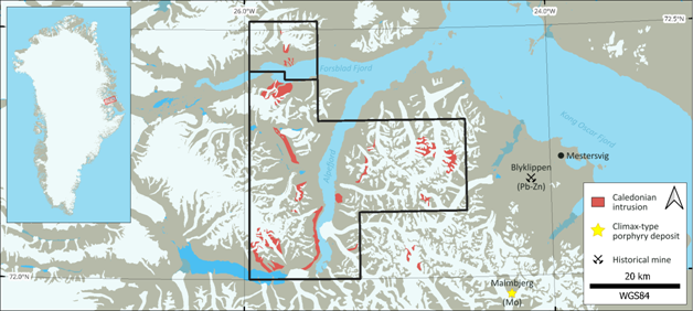
Figure 1: Location map of new Eleonore North licences in East Greenland with prospective Caledonian intrusions.
GreenX CEO, Mr Ben Stoikovich, commented: "Securing 1,600 km² of new gold and critical minerals tenure takes our Eleonore North portfolio to approximately 2,100 km² across four licences and gives us exclusive rights to a suite of Caledonian intrusions that have never been tested against the reduced intrusion-related gold model. Documented gold and scheelite anomalism have sat in the public record here since the 1980s without follow-up. We have teams on the ground testing these intrusions this season, with a clear and disciplined program of work through 2026."
HISTORICAL GOLD RESULTS
In 1975, Nordisk Mineselskab A/S (Nordmine) collected gold-mineralised boulders and veins from the area now covered by the new licences (Table 1). Follow-up exploration involved stream sediment sampling throughout the region in 1979 and 1980. Heavy mineral concentrates from the earlier surveys were analysed in 1983. Gold, scheelite, and other indicator elements were detected within the licence areas. In 1983, geologists visited the site and recommended detailed follow-up exploration for gold and scheelite; however, no further exploration was conducted. Nordmine held an exclusive mineral licence covering 100,000 km2 in East Greenland until its liquidation in 1992.
|
Sample # |
Au (g/t) |
Company |
Longitude |
Latitude |
Year |
|
7512078/5 |
50 |
Nordmine |
-25.79437 |
72.43450 |
1975 |
|
8313013/B |
26 |
Nordmine |
-25.80941 |
72.44610 |
1983 |
|
7505590 |
12.7 |
Nordmine |
-25.81334 |
72.43415 |
1975 |
|
8313011/D |
5.4 |
Nordmine |
-25.80574 |
72.44088 |
1983 |
|
8313012/A |
4.6 |
Nordmine |
-25.80448 |
72.44385 |
1983 |
|
7910508 |
2.0 |
Nordmine |
-25.69453 |
72.44298 |
1979 |
Table 1: Selected historical grab sample results sourced from a publicly available Greenland government database.
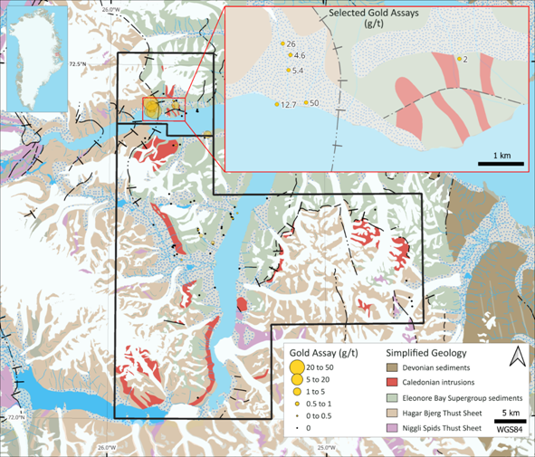
Figure 2: Simplified geological map with historical Nordmine grab sample gold results. The inset map shows the location of selected historical high-grade grab samples from Table 1. All results are available in Appendix 1.
Geology - GOLD AND CRITICAL MINERALS POTENTIAL
The geological setting of the area is characterised by gneissic basement rocks and Proterozoic metasediments (Figure 2), separated by a major north-south thrust fault extending for 400 km (Figure 4). Thrusting and folding during the Caledonian orogeny juxtaposed the different rock packages. This major structure likely provided conduits for magma and later mineralised fluids. Caledonian intrusions are today found adjacent to fault zones in Eleonore Bay Supergroup sediments.
RIRGS deposits feature a geochemical zonation that changes with distance from the causative intrusion. Metal enrichments proximal to gold mineralisation typically include tungsten (W) and antimony (Sb). Geochemical signatures distal to gold mineralisation include enrichments in silver (Ag), copper (Cu), lead (Pb), and zinc (Zn). At the regional scale, arsenic (As) is a useful indicator for vectoring towards RIRGS-mineralised intrusions.
Regional stream sediment sampling included panning for heavy mineral concentrates. Analysis of the concentrate included counting grains of the tungsten-bearing mineral, scheelite. Figure 3 below shows the scheelite grain count in panned heavy mineral concentrates. There is a strong association between the Caledonian granites and high scheelite grain counts. The spatial association also applies to Au, Ag, Cu, Pb, Zn, and As in panned heavy mineral concentrates.
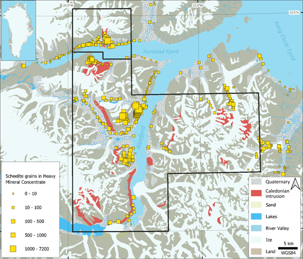
Figure 3: Scheelite grain count in historical panned heavy mineral concentrate samples.
CRITICAL MINERALS
Tungsten is designated as a Strategic Raw Material by the EU and a critical raw mineral by the US. Tungsten is one of the foremost defence materials, widely used in high-strength applications and ammunition. It is also suitable for high-temperature applications, such as supersonic and hypersonic vehicles. Tungsten's density makes it ideal for armour-piercing ammunition and counterweights in spacecraft. Commercially, it is mainly used when high strength is required, such as for cutting and construction tools. Global strategic interest in tungsten increased significantly in February 2025, when China announced sweeping export controls targeting tungsten and four other metals used across defence, clean energy and other industries. China's export controls were announced minutes after an additional 10% tariff on Chinese goods imposed by the U.S. President came into effect.
About 90% of global tungsten comes from Russia, China and North Korea, with China alone accounting for about 80% of the world's tungsten output. The US has not had domestic tungsten production since 2015.
Work Programs
GreenX's land tenure at Eleonore North now includes four licences (Figure 4). Prior to the summer fieldwork, the Company re-logged and re-assayed archive drill core from the historical North Margeries Sb-W and South Margeries W deposits. Additionally, historical airborne hyperspectral survey data covering the Margeries deposits was reprocessed (refer to announcement dated 14 May 2026). That data provided new targets which were visited during the field season. Results from the July 2026 fieldwork are expected in the coming months.
Table 2: Summary of work at each Eleonore North licence.
|
Licence Code |
Target |
2026 Work Program |
|
MEL-S 2026-120 & MEL 2026-124 |
Caledonian Intrusions |
· Reconnaissance sampling and mapping at target intrusions (July 2026). |
|
MEL 2023-39 |
Noa Pluton |
· Sampling and mapping at the Noa Pluton Sb-Au-W prospect (July 2026). |
|
MEL 2018-19 |
North and South Margeries |
· Bulk sampling Sb and W material from the Margeries deposits for sighter metallurgical test work (July 2026). · Re-processing airborne hyperspectral survey data (May 2026). · Core re-logging and re-sampling (May 2026). |
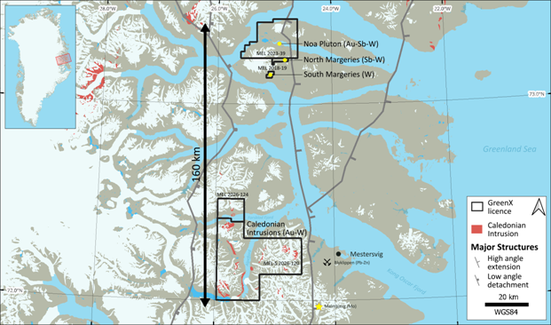
Figure 4: GreenX's Eleonore North Project now comprises a portfolio of four exploration licences in East Greenland.
ISSUE OF SHARES
In accordance with the revised commercial terms of the option agreement under which GreenX acquired the Eleonore North Project (refer to announcement dated 15 July 2024), the grant of exploration licence MEL 2026-124 requires GreenX to issue the original vendor of Eleonore North GreenX shares with a value of A$250,000, calculated using the five-trading-day VWAP prior to the date of this announcement.
ENQUIRIES
|
Ben Stoikovich Chief Executive Officer
+44 207 478 3900 |
Kazimierz Chojna Investor Relations - Poland
Kim Eckhof Investor Relations - UK / Germany |
Competent Persons Statement
Information in this announcement that relates to Exploration Results is based on, and fairly represents, information compiled by Mr Joel Burkin, a Competent Person who is a member of the Australian Institute of Geoscientists. Mr Burkin is a consultant engaged by GreenX and is a holder of unlisted options in GreenX. Mr Burkin has sufficient experience that is relevant to the style of mineralisation and type of deposit under consideration and to the activity being undertaken, to qualify as a Competent Person as defined in the 2012 Edition of the 'Australasian Code for Reporting of Exploration Results, Mineral Resources and Ore Reserves'. Mr Burkin consents to the inclusion in this announcement of the matters based on his information, in the form and context in which they appear.
Forward Looking Statements
This release may include forward-looking statements, which may be identified by words such as "expects", "anticipates", "believes", "projects", "plans", and similar expressions. These forward-looking statements are based on GreenX's expectations and beliefs concerning future events. Forward looking statements are necessarily subject to risks, uncertainties and other factors, many of which are outside the control of GreenX, which could cause actual results to differ materially from such statements. There can be no assurance that forward-looking statements will prove to be correct. GreenX makes no undertaking to subsequently update or revise the forward-looking statements made in this release, to reflect the circumstances or events after the date of that release.
The information contained within this announcement is deemed to constitute inside information as stipulated under the Regulation 2014/596/EU which is part of domestic law pursuant to the Market Abuse (Amendment) (EU Exit) Regulations (SI 2019/310) ("UK MAR"). By the publication of this announcement via a Regulatory Information Service, this inside information (as defined in UK MAR) is now considered to be in the public domain.
APPENDIX 1: Nordmine GRab sample database
|
Sample ID |
Longitude |
Latitude |
Elevation (m AMSL) |
Au (g/t) |
|
7512078/5 |
-25.79437 |
72.43450 |
5 |
50 |
|
8313013/B |
-25.80941 |
72.44610 |
680 |
26 |
|
7505590 |
-25.81334 |
72.43415 |
10 |
12.7 |
|
8313011/D |
-25.80574 |
72.44088 |
250 |
5.4 |
|
8313012/A |
-25.80448 |
72.44385 |
440 |
4.6 |
|
7002295 |
-25.54476 |
72.40169 |
5 |
2.5 |
|
7910508 |
-25.69453 |
72.44298 |
520 |
2 |
|
8313011/C |
-25.80574 |
72.44088 |
250 |
0.81 |
|
8007047 |
-25.57353 |
72.25901 |
1060 |
0.55 |
|
7506375 |
-25.51893 |
72.24901 |
500 |
0.54 |
|
7909550 |
-25.42723 |
72.28341 |
50 |
0.37 |
|
7910545 |
-25.70472 |
72.44963 |
1010 |
0.34 |
|
7612494/8 |
-25.69135 |
72.38661 |
50 |
0.28 |
|
8007048 |
-25.58561 |
72.26749 |
1290 |
0.24 |
|
7411307 |
-25.70453 |
72.44107 |
550 |
0.2 |
|
7612513/2 |
-25.40572 |
72.29098 |
1 |
0.063 |
|
7002292 |
-25.66334 |
72.22473 |
300 |
0.06 |
|
7612499 |
-25.55778 |
72.39709 |
100 |
0.039 |
|
7002409 |
-25.69437 |
72.24492 |
800 |
0.03 |
|
7910566 |
-25.59235 |
72.43712 |
185 |
0.021 |
|
8313011/F |
-25.80574 |
72.44088 |
390 |
0.019 |
|
8007252/2 |
-25.58787 |
72.26871 |
1370 |
0.005 |
|
7909558 |
-25.43731 |
72.29030 |
160 |
0.004 |
|
8007254/1 |
-25.58221 |
72.26275 |
1180 |
0.004 |
|
7612495/5 |
-25.69135 |
72.38661 |
10 |
0.003 |
|
8007252/1 |
-25.58787 |
72.26871 |
1370 |
0.002 |
|
8007253/1 |
-25.58754 |
72.26643 |
1270 |
0.002 |
|
8313008/E |
-25.79437 |
72.43450 |
40 |
0.002 |
|
6902226 |
-24.60314 |
72.16495 |
650 |
0 |
|
6902227 |
-24.60314 |
72.16495 |
670 |
0 |
|
6902229 |
-24.60129 |
72.15756 |
710 |
0 |
|
7002093 |
-24.62617 |
72.19390 |
1200 |
0 |
|
7002142 |
-24.61369 |
72.17008 |
760 |
0 |
|
7002144 |
-24.61369 |
72.17008 |
810 |
0 |
|
7002145 |
-24.61369 |
72.17008 |
790 |
0 |
|
7002146 |
-24.61369 |
72.17008 |
840 |
0 |
|
7002147 |
-24.61369 |
72.17008 |
800 |
0 |
|
7002288 |
-25.43291 |
72.28555 |
50 |
0 |
|
7002289 |
-25.66334 |
72.22473 |
300 |
0 |
|
7406151 |
-25.41788 |
72.29925 |
140 |
0 |
|
7505591 |
-25.81334 |
72.43415 |
5 |
0 |
|
7506169 |
-25.59005 |
72.43423 |
5 |
0 |
|
7506170 |
-25.59005 |
72.43423 |
0 |
0 |
|
7506171 |
-25.64446 |
72.43167 |
0 |
0 |
|
7506172 |
-25.64446 |
72.43167 |
0 |
0 |
|
7506175 |
-25.26782 |
72.31160 |
0 |
0 |
|
7506176 |
-25.43291 |
72.28555 |
50 |
0 |
|
7506177 |
-25.39624 |
72.21256 |
0 |
0 |
|
7506178 |
-25.39624 |
72.21256 |
0 |
0 |
|
7512059 |
-25.50896 |
72.18572 |
5 |
0 |
|
7905816 |
-25.58065 |
72.17494 |
1240 |
0 |
|
7906915 |
-25.69100 |
72.44992 |
980 |
0 |
|
7907824 |
-25.47875 |
72.26946 |
550 |
0 |
|
7909532 |
-25.42557 |
72.28252 |
50 |
0 |
|
7909533 |
-25.42557 |
72.28252 |
50 |
0 |
|
7909542 |
-25.43600 |
72.28910 |
130 |
0 |
|
7909549 |
-25.46979 |
72.25985 |
250 |
0 |
|
7909552 |
-25.42769 |
72.28460 |
80 |
0 |
|
7909555 |
-25.42769 |
72.28460 |
100 |
0 |
|
7909561 |
-25.53083 |
72.23392 |
130 |
0 |
|
7909566 |
-25.70279 |
72.24232 |
800 |
0 |
|
7909568 |
-25.68435 |
72.23262 |
720 |
0 |
|
7909569 |
-25.70609 |
72.24303 |
820 |
0 |
|
7909570 |
-25.69641 |
72.23072 |
530 |
0 |
|
7909576 |
-25.70279 |
72.24232 |
750 |
0 |
|
7909578 |
-25.70098 |
72.24500 |
910 |
0 |
|
7909580 |
-25.79402 |
72.27403 |
650 |
0 |
|
7909581 |
-25.79402 |
72.27403 |
650 |
0 |
|
7909585 |
-25.71311 |
72.30384 |
1150 |
0 |
|
7909586 |
-25.62229 |
72.30640 |
1210 |
0 |
|
7909589 |
-25.72170 |
72.31760 |
1500 |
0 |
|
7909765 |
-25.60582 |
72.30815 |
N/A |
0 |
|
7910503 |
-25.67592 |
72.43709 |
290 |
0 |
|
7910558 |
-25.59444 |
72.43460 |
2 |
0 |
|
7910749 |
-25.67254 |
72.38749 |
N/A |
0 |
|
8007046 |
-25.55417 |
72.26174 |
1060 |
0 |
|
8009326 |
-25.58634 |
72.03015 |
10 |
0 |
|
8009346 |
-25.83564 |
72.39624 |
210 |
0 |
|
8009509 |
-25.81391 |
72.39689 |
90 |
0 |
|
8313009 |
-25.79437 |
72.43450 |
105 |
0 |
|
7406155/1 |
-25.43291 |
72.28555 |
75 |
0 |
|
7406155/4 |
-25.43291 |
72.28555 |
75 |
0 |
|
7512071/5 |
-25.70369 |
72.38633 |
15 |
0 |
|
7512077/6 |
-25.81334 |
72.43415 |
5 |
0 |
|
7512079/3 |
-25.79437 |
72.43450 |
5 |
0 |
|
7512095/5 |
-25.66439 |
72.42788 |
5 |
0 |
|
7612504/2 |
-25.51833 |
72.24696 |
790 |
0 |
|
7612525/8 |
-25.51833 |
72.24696 |
550 |
0 |
|
7906906/1 |
-25.70210 |
72.44885 |
1045 |
0 |
|
7907822/1 |
-25.47875 |
72.26946 |
600 |
0 |
|
7907822/2 |
-25.47875 |
72.26946 |
600 |
0 |
|
7907822/9 |
-25.47875 |
72.26946 |
600 |
0 |
|
7907823/1 |
-25.47805 |
72.27156 |
600 |
0 |
|
8007252/3 |
-25.58787 |
72.26871 |
1370 |
0 |
|
8007253/2 |
-25.58754 |
72.26643 |
1270 |
0 |
|
8007259/1 |
-24.76686 |
72.29470 |
870 |
0 |
|
8313008/A |
-25.79437 |
72.43450 |
15 |
0 |
|
8313008/B |
-25.79437 |
72.43450 |
15 |
0 |
|
8313008/C |
-25.79437 |
72.43450 |
15 |
0 |
|
8313008/D |
-25.79437 |
72.43450 |
25 |
0 |
|
8313008/F |
-25.79437 |
72.43450 |
65 |
0 |
|
8313008/G |
-25.79437 |
72.43450 |
75 |
0 |
|
8313008/H |
-25.79437 |
72.43450 |
75 |
0 |
|
8313008/J |
-25.79437 |
72.43450 |
95 |
0 |
|
8313010/A |
-25.75064 |
72.45901 |
1120 |
0 |
|
8313010/B |
-25.75064 |
72.45901 |
1120 |
0 |
|
8313010/C |
-25.75064 |
72.45901 |
1120 |
0 |
|
8313010/D |
-25.75064 |
72.45901 |
1140 |
0 |
|
8313010/E |
-25.75064 |
72.45901 |
1160 |
0 |
|
8313010/F |
-25.75064 |
72.45901 |
1190 |
0 |
|
8313010/G |
-25.75064 |
72.45901 |
1210 |
0 |
|
8313010/H |
-25.75064 |
72.45901 |
1250 |
0 |
|
8313011/A |
-25.80574 |
72.44088 |
130 |
0 |
|
8313011/B |
-25.80574 |
72.44088 |
220 |
0 |
|
8313011/E |
-25.80574 |
72.44088 |
360 |
0 |
|
8313011/G |
-25.80574 |
72.44088 |
390 |
0 |
|
8313011/H |
-25.80574 |
72.44088 |
420 |
0 |
|
8313012/B |
-25.80448 |
72.44385 |
440 |
0 |
|
8313013/A |
-25.80941 |
72.44610 |
570 |
0 |
|
Note: Coordinates are decimal degrees in the WGS84 system. |
||||
JORC Code, 2012 Edition - Table 1 report
Section 1 Sampling Techniques and Data
(Criteria in this section apply to all succeeding sections.)
|
Criteria |
JORC Code explanation |
Commentary |
|
Sampling techniques |
Nature and quality of sampling (eg cut channels, random chips, or specific specialised industry standard measurement tools appropriate to the minerals under investigation, such as down hole gamma sondes, or handheld XRF instruments, etc). These examples should not be taken as limiting the broad meaning of sampling. Include reference to measures taken to ensure sample representivity and the appropriate calibration of any measurement tools or systems used. Aspects of the determination of mineralisation that are Material to the Public Report. In cases where 'industry standard' work has been done this would be relatively simple (eg 'reverse circulation drilling was used to obtain 1 m samples from which 3 kg was pulverised to produce a 30 g charge for fire assay'). In other cases more explanation may be required, such as where there is coarse gold that has inherent sampling problems. Unusual commodities or mineralisation types (eg submarine nodules) may warrant disclosure of detailed information. |
Historical geochemical results reported herein were sourced from publicly available Greenland government databases. Details of the sampling techniques employed are not available. |
|
Drilling techniques |
Drill type (eg core, reverse circulation, open-hole hammer, rotary air blast, auger, Bangka, sonic, etc) and details (eg core diameter, triple or standard tube, depth of diamond tails, face-sampling bit or other type, whether core is oriented and if so, by what method, etc). |
Not applicable. No drilling results are being reported as the results are based on grab samples |
|
Drill sample recovery |
Method of recording and assessing core and chip sample recoveries and results assessed. Measures taken to maximise sample recovery and ensure representative nature of the samples. Whether a relationship exists between sample recovery and grade and whether sample bias may have occurred due to preferential loss/gain of fine/coarse material. |
Not applicable. No drilling results are being reported as the results are based on grab samples.
|
|
Logging |
Whether core and chip samples have been geologically and geotechnically logged to a level of detail to support appropriate Mineral Resource estimation, mining studies and metallurgical studies. Whether logging is qualitative or quantitative in nature. Core (or costean, channel, etc) photography. The total length and percentage of the relevant intersections logged. |
Not applicable. No drilling results are being reported as the results are based on grab samples. No Mineral Resource estimation, mining studies and metallurgical studies included in this announcement.
|
|
Sub-sampling techniques and sample preparation |
If core, whether cut or sawn and whether quarter, half or all core taken. If non-core, whether riffled, tube sampled, rotary split, etc and whether sampled wet or dry. For all sample types, the nature, quality and appropriateness of the sample preparation technique. Quality control procedures adopted for all sub-sampling stages to maximise representivity of samples. Measures taken to ensure that the sampling is representative of the in situ material collected, including for instance results for field duplicate/second-half sampling. Whether sample sizes are appropriate to the grain size of the material being sampled. |
Information on sample preparation methods is not available from the historical records reviewed.
|
|
Quality of assay data and laboratory tests |
The nature, quality and appropriateness of the assaying and laboratory procedures used and whether the technique is considered partial or total. For geophysical tools, spectrometers, handheld XRF instruments, etc, the parameters used in determining the analysis including instrument make and model, reading times, calibrations factors applied and their derivation, etc. Nature of quality control procedures adopted (eg standards, blanks, duplicates, external laboratory checks) and whether acceptable levels of accuracy (ie lack of bias) and precision have been established. |
Information regarding analytical methods, laboratory accreditation, standards, blanks and duplicates is not available. Accordingly, the Company is unable to assess the quality assurance and quality control measures applied to the historical data.
|
|
Verification of sampling and assaying |
The verification of significant intersections by either independent or alternative company personnel. The use of twinned holes. Documentation of primary data, data entry procedures, data verification, data storage (physical and electronic) protocols. Discuss any adjustment to assay data. |
The Company has not independently verified the reported results through resampling or twin sampling. The historical results are being used as exploration rationale for the region. The area where historical results are reported was visited during fieldwork in July 2026. Samples were collected and have been sent for assay analysis with results due in the coming months.
|
|
Location of data points |
Accuracy and quality of surveys used to locate drill holes (collar and down-hole surveys), trenches, mine workings and other locations used in Mineral Resource estimation. Specification of the grid system used. Quality and adequacy of topographic control. |
Sample locations were obtained from publicly available Greenland government databases. Selected historical grab sample results are shown in Table 1. Full historical database is included in Appendix 1. Sample locations are displayed in Figure 2. The grid system used is WGS84, with latitude and longitude reported in decimal degrees. |
|
Data spacing and distribution |
Data spacing for reporting of Exploration Results. Whether the data spacing and distribution is sufficient to establish the degree of geological and grade continuity appropriate for the Mineral Resource and Ore Reserve estimation procedure(s) and classifications applied. Whether sample compositing has been applied. |
The location of historical third-party stream sediment samples is dictated by the stream network. The coverage is considered adequate for conceptual and regional targeting.
The spacing of historical third-party grab samples is not sufficient to establish geological and grade continuity. No Mineral Resources or Ore Reserves are being estimated. The results are being used for conceptual targeting and to illustrate the mineralisation potential in the area.
It is unknown if the historical third-party composited results. The Company did not composite historical results. |
|
Orientation of data in relation to geological structure |
Whether the orientation of sampling achieves unbiased sampling of possible structures and the extent to which this is known, considering the deposit type. If the relationship between the drilling orientation and the orientation of key mineralised structures is considered to have introduced a sampling bias, this should be assessed and reported if material. |
Not applicable to stream sediments or grab samples as no drilling results are included in this announcement. Refer to Appendix 1 for table of results. |
|
Sample security |
The measures taken to ensure sample security. |
It is unknown what sample security measures were taken by third parties in the past. |
|
Audits or reviews |
The results of any audits or reviews of sampling techniques and data. |
No audits or reviews have taken place by the Company. The data has been curated and stored by GEUS. |
Section 2 Reporting of Exploration Results
(Criteria listed in the preceding section also apply to this section.)
|
Criteria |
JORC Code explanation |
Commentary |
|
Mineral tenement and land tenure status |
Type, reference name/number, location and ownership including agreements or material issues with third parties such as joint ventures, partnerships, overriding royalties, native title interests, historical sites, wilderness or national park and environmental settings. The security of the tenure held at the time of reporting along with any known impediments to obtaining a licence to operate in the area. |
The Eleonore North project comprises four licences. MEL 2018-19 covers North Margeries and South Margeries prospects with an official area of 31.04 km2. MEL 2023-39 covers the Noa Pluton prospect with an official area of 494.263 km2. MEL 2026-124 covers the Forsblad prospect with an official area of 147.151 km2. MEL-S 2026-120 covers the Alpefjord prospects with an official area of 1,411.674 km2.
The location of all licences is shown in Figure 4 in the body of this announcement.
The exploration licences are currently in good standing. GreenX owns 100% of the licences following the conclusion of a revised option agreement as announced on 15 July 2024. GreenX will issue a 1.5% NSR to Greenfields Exploration for MEL 2018-19, MEL 2023-39, and MEL 2026-124. |
|
Exploration done by other parties |
Acknowledgment and appraisal of exploration by other parties. |
In 1975, Nordmine collected gold-mineralised boulders and veins from the area now covered by the new licences (Forsblad Fjord (MEL 2026-124) and Alpefjord MEL-S 2026-120). Follow-up exploration involved stream sediment sampling throughout the region in 1979 and 1980.
Heavy mineral concentrates from the earlier surveys were analysed in 1983. Gold, scheelite, and other indicator elements were detected within the licence areas.
In 1983, geologists visited the site and recommended detailed follow-up exploration for gold and scheelite, however no further exploration was conducted.
Nordmine held an exclusive mineral licence covering 100,000 km2 in East Greenland until its liquidation in 1992. |
|
Geology |
Deposit type, geological setting and style of mineralisation. |
Reduced Intrusion-Related Gold Systems (RIRGS) are gold deposits genetically associated with reduced, typically felsic intrusions and are characterised by broadly disseminated gold mineralisation in sheeted veins, stockworks, breccias and intrusion-margin settings. They commonly exhibit a geochemical association of Au with Bi, Te, W, As and Sb, and may occur as large, low- to moderate-grade systems with significant tonnage potential.
The project area lies within the East Greenland Caledonides, a Silurian-Devonian collisional orogen formed during closure of the Iapetus Ocean and collision of Laurentia and Baltica. Caledonian felsic intrusions were emplaced during syn- to post-collisional crustal thickening and exhumation and intrude Laurentian basement gneisses and supracrustal sequences. This tectono-magmatic setting is considered prospective for intrusion-related and structurally controlled gold mineralisation.
The Caledonian granitoids of East Greenland are also prospective for intrusion-related tungsten mineralisation, including vein systems and scheelite-bearing skarns where felsic intrusions interact with reactive carbonate-bearing stratigraphy. |
|
Drill hole Information |
A summary of all information material to the understanding of the exploration results including a tabulation of the following information for all Material drill holes: · easting and northing of the drill hole collar · elevation or RL (Reduced Level - elevation above sea level in metres) of the drill hole collar · dip and azimuth of the hole · down hole length and interception depth · hole length. If the exclusion of this information is justified on the basis that the information is not Material and this exclusion does not detract from the understanding of the report, the Competent Person should clearly explain why this is the case. |
No drilling results are being reported as the results are based on grab samples. Refer to Appendix 1 for table of results. |
|
Data aggregation methods |
In reporting Exploration Results, weighting averaging techniques, maximum and/or minimum grade truncations (eg cutting of high grades) and cut-off grades are usually Material and should be stated. Where aggregate intercepts incorporate short lengths of high grade results and longer lengths of low grade results, the procedure used for such aggregation should be stated and some typical examples of such aggregations should be shown in detail. The assumptions used for any reporting of metal equivalent values should be clearly stated. |
No drilling results are being reported as the results are based on grab samples. Refer to Appendix 1 for table of results.
|
|
Relationship between mineralisation widths and intercept lengths |
These relationships are particularly important in the reporting of Exploration Results. If the geometry of the mineralisation with respect to the drill hole angle is known, its nature should be reported. If it is not known and only the down hole lengths are reported, there should be a clear statement to this effect (eg 'down hole length, true width not known'). |
No drilling results or mineralisation widths are being reported as the results are based on grab samples. Refer to Appendix 1 for table of results. |
|
Diagrams |
Appropriate maps and sections (with scales) and tabulations of intercepts should be included for any significant discovery being reported These should include, but not be limited to a plan view of drill hole collar locations and appropriate sectional views. |
Appropriate maps are included in the main body of this announcement. |
|
Balanced reporting |
Where comprehensive reporting of all Exploration Results is not practicable, representative reporting of both low and high grades and/or widths should be practiced to avoid misleading reporting of Exploration Results. |
The results presented are selected historical anomalous samples from a larger publicly available dataset and are intended to illustrate the presence of documented gold anomalism within the project area. |
|
Other substantive exploration data |
Other exploration data, if meaningful and material, should be reported including (but not limited to): geological observations; geophysical survey results; geochemical survey results; bulk samples - size and method of treatment; metallurgical test results; bulk density, groundwater, geotechnical and rock characteristics; potential deleterious or contaminating substances. |
Historical geochemical data presented in figures and tables were sourced from publicly available Greenland government databases. The reliability of the historical data cannot be fully assessed because details of sampling procedures, analytical methods and QAQC protocols are unavailable. |
|
Further work |
The nature and scale of planned further work (eg tests for lateral extensions or depth extensions or large-scale step-out drilling). Diagrams clearly highlighting the areas of possible extensions, including the main geological interpretations and future drilling areas, provided this information is not commercially sensitive. |
Fieldwork is now completed for the 2026 season. Samples and bulk material are being sent for analysis. Data synthesis and exploration targeting can progress after results are received. Extensional and infill drilling could be warranted if the sighter test work is positive at North and/or South Margeries. Results from Noa Pluton and the Caledonian Intrusion targets will be evaluated by a RIRGS specialist to form a view on follow-up exploration programs.
|
RNS may use your IP address to confirm compliance with the terms and conditions, to analyse how you engage with the information contained in this communication, and to share such analysis on an anonymised basis with others as part of our commercial services. For further information about how RNS and the London Stock Exchange use the personal data you provide us, please see our Privacy Policy.

Latest directors dealings
- 23 seconds ago Barclays
- 25 minutes ago Diageo
- 38 minutes ago Mortgage Advice Bureau (Holdings)
- 55 minutes ago PZ Cussons
- 56 minutes ago NCC Group