December 2025 O'Callaghans Mineral Resource Stmt.
Summary by AI BETAClose X
 Greatland Resources Limited
E: info@greatland.com.au
W: https://greatland.com.au
 : x.com/greatlandgold
NEWS RELEASE | 30 March 2026
December 2025 O'Callaghans Mineral Resource Statement
THIS ANNOUNCEMENT CONTAINS INSIDE INFORMATION AS STIPULATED UNDER THE UK MARKET ABUSE REGULATIONS. ON PUBLICATION OF THIS ANNOUNCEMENT VIA A REGULATORY INFORMATION SERVICE, THIS INFORMATION IS CONSIDERED TO BE IN THE PUBLIC DOMAIN.
O'Callaghans - A globally significant Tungsten Resource
Mineral Resource Estimate for high grade 70Mt Tungsten-Copper-Lead-Zinc deposit
Greatland Resources Limited (Greatland or Company) (AIM:GGP, ASX:GGP) is pleased to provide a Mineral Resource Estimate (MRE) for the O'Callaghans tungsten-copper-zinc-lead deposit (O'Callaghans) as at 31 December 2025. O'Callaghans was previously reported as a Mineral Resource & Ore Reserve prior to Greatland ownership.
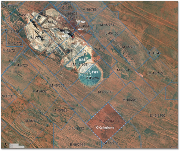
O'Callaghans is one of the largest high-grade tungsten deposits globally and benefits from significant copper, zinc and lead mineralisation. O'Callaghans is 100% owned by Greatland and located just 10km south of Telfer on a mining lease (M45/203) (Figure 1).
Key highlights:
§ Greatland MRE: 70Mt @ 0.35% tungsten trioxide (WO3) / 0.30% Cu / 0.57% Zn / 0.28% Pb for 246Kt WO3 / 207Kt Cu / 371Kt Zn / 182Kt Pb.
§ Globally significant strategic asset: O'Callaghans is one of the largest high-grade tungsten deposits globally (Figure 2). Tungsten is designated as a critical mineral by many countries including Australia, the United States, the European Union, Canada, the United Kingdom, Japan and India.
- Tungsten's extreme melting point, hardness and density make it ideal and difficult to substitute for various applications including in mining, construction, automotive, aerospace, defence, industrial and chemical. Aerospace and defence applications currently account for ~25% of global tungsten demand.
China currently produces ~80% of global tungsten supply but imposed export controls on tungsten in early 2025. Historically a net exporter of tungsten, China became a very significant net importer of tungsten in 2025.
- These and other geopolitical factors have contributed to a ~500% increase in benchmark pricing for Ammonium Para Tungstate (APT), a high purity tungsten compound, since February 2025, to ~US$2,200 per metric tonne unit (MTU; 1 MTU = 10kg). The O'Callaghans MRE uses pricing of US$450/MTU APT.
§ Work to date: O'Callaghans benefits from significant drilling and study work completed by previous owners.
- The MRE is considered well informed with 71,000m of drilling from 184 drill holes (100m x 100m spacing) supporting the predominantly (>95%) higher confidence Indicated Mineral Resource.
- Newcrest Mining Limited (Newcrest) historically reported an O'Callaghans Ore Reserve as recently as 2020, that was supported by a Newcrest 2014 Pre-Feasibility Study (PFS) that demonstrated a technically and economically viable long life mining operation. The PFS contemplated a long-hole open stoping with paste fill, utilising truck haulage and a standalone 2.0Mpta processing facility and APT plant.
- The PFS processing flowsheet was sequential flotation (copper, lead, zinc, and pyrite), followed by magnetic separation and gravity recovery of tungsten concentrate. The PFS contemplated an APT plant to convert tungsten concentrate into high purity APT. Metallurgical test work was completed as part of the PFS and is the basis for the MRE net smelter return (NSR) recovery assumptions of: W 70%, Cu 82.4%, Zn 76.2% and Pb 70.4%.
§ Infrastructure: O'Callaghans is strategically located just 10km south of Greatland's Telfer mine, with synergy potential from the sharing of Telfer's significant existing non-processing infrastructure.
Greatland Managing Director, Shaun Day, commented:
"O'Callaghans is a globally significant tungsten and base metals deposit that presents latent value and optionality within Greatland's portfolio, particularly in the strong prevailing tungsten market conditions.
"Greatland's first Mineral Resource Estimate for the deposit delineates a high grade 70 million tonne resource, the vast majority in the high confidence Indicated Resource category, providing a clearer basis to understand the scale and quality of this strategic asset.
"O'Callaghans is one of the world's largest high grade tungsten deposits, in close proximity to our Telfer mine which provides the potential to benefit from sharing of some of Telfer's non-processing infrastructure. While our primary focus will remain Telfer and Havieron, we are considering appropriate options to demonstrate and enhance the project's value within the Greatland portfolio."
Contact
For further information, please contact:
Greatland Resources Limited
Shaun Day, Managing Director | Andrew Bowler, Head of Investor Relations
Nominated Advisor
SPARK Advisory Partners
Andrew Emmott / James Keeshan / Neil Baldwin | +44 203 368 3550
Corporate Brokers
Canaccord Genuity | James Asensio / George Grainger | +44 207 523 8000
RBC Capital Markets | James Agnew / Jamil Miah | Scott Redwood | +44 207 029 0528
Media Relations
Australia - Fivemark Partners | Michael Vaughan | +61 422 602 720
About Greatland
Greatland is a gold and copper mining company listed on the Australian Securities Exchange and London Stock Exchange's AIM Market (ASX:GGP and AIM:GGP) and operates its business from Western Australia.
The Greatland portfolio includes the 100% owned Telfer mine, the adjacent 100% owned brownfield world-class Havieron gold-copper development project, and a significant exploration portfolio within the surrounding region. The combination of Telfer and Havieron provides for a substantial and long life gold-copper operation in the Paterson Province in the East Pilbara region of Western Australia.
2025 O'Callaghans Mineral Resource
O'Callaghans is located 10km south of Telfer on mining lease M45/203 (Figure 1), in the Paterson Province of the East Pilbara region in Western Australia, approximately 485 km by road south-east of Port Hedland.
Figure 1: Satellite image showing Telfer mine and infrastructure and O'Callaghans deposit location
The O'Callaghans MRE is detailed in Table 1 below.
Table 1: 2025 O'Callaghans Mineral Resource Statement
|
Classification |
Tonnes |
Tungsten Trioxide (WO3) |
Copper |
Zinc |
Lead |
||||
|
Mt |
Grade % |
Metal kt |
Grade % |
Metal kt |
Grade % |
Metal kt |
Grade % |
Metal kt |
|
|
Indicated |
65 |
0.35 |
232 |
0.30 |
195 |
0.58 |
358 |
0.28 |
176 |
|
Inferred |
4 |
0.31 |
14 |
0.28 |
12 |
0.39 |
13 |
0.19 |
7 |
|
Total |
70 |
0.35 |
246 |
0.30 |
207 |
0.57 |
371 |
0.28 |
182 |
Notes:
Mineral Resources are reported as at 31 December 2025, grades are reported to two decimal places to reflect appropriate precision in the estimate, and this may cause apparent discrepancies in totals. Cutoffs for the O'Callaghans MRE are applied based on a NSR using metal prices of US$25.74 lb W (equivalent to ~US$450/MTU APT), US$4.54 lb Cu, US$1.27 lb Zn and US$0.93 lb Pb.
O'Callaghans is one of the largest high grade tungsten deposits globally. Figure 2 below illustrates the deposit's positioning relative to other tungsten resources outside of China, Russia and North Korea.
Importantly, O'Callaghans also benefits from significant grades of recoverable copper (0.30%), zinc (0.67%) and lead (0.28%) (not included in Figure 2 which shows tungsten only).
Figure 2: Benchmarking of O'Callaghans MRE against global (ex-China, Russia and North Korea) tungsten deposits
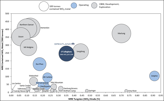
Notes: Based on publicly available resource information - may not be an exhaustive list. Refer to the Appendix for associated sources. Resources are reported in accordance with JORC (2012) or NI 43-101. See the Appendix section for comparison data sources.
Additional Information on the O'Callaghans Mineral Resource Estimate
O'Callaghans
The O'Callaghans deposit is 100% owned by Greatland Resource Ltd and located 10km south of Greatland's Telfer gold-copper mine (Figure 1), in the Paterson Province of the East Pilbara region in Western Australia, approximately 485 km by road south-east of Port Hedland. The O'Callaghans Mineral Resource is located within an approved mining lease, M45/203.
Geology
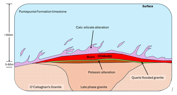
The O'Callaghans deposit lies at the contact between the Proterozoic Puntapunta Formation and the O'Callaghans granite. The Puntapunta Formation conformably underlies the Wilki Quartzite and overlies the Telfer Formation, and is described as an outer carbonate shelf deposit consisting of well-bedded, clastic dolomite and limestone, with lesser amounts of calcareous sandstone and siltstone. The O'Callaghans granite has been identified at around 350 m below surface with drilling having defined a zone of poly-metallic skarn mineralisation up to 60m thick above the granite limestone contact. The O'Callaghans suite is directly associated with complex skarn zones, including pyrite-pyrrotite-magnetite skarns with a strong magnetic expression.
Figure 3: Schematic geological section of O'Callaghans deposit
Mineralisation
Mineralisation containing potentially economic quantities of tungsten, copper, zinc and lead has been identified approximately 300m below surface as a sub-horizontal layer of poly-metallic skarn (altered limestone) mineralisation up to 60m thick on the contact between a large granitic intrusion and overlying limestones (Figure 3). Tungsten-bearing minerals include both scheelite and wolframite. Molybdenum and silver are present but are not currently considered economically significant.
Drilling Overview
Exploration during the 1980s-1990s at O'Callaghans targeted skarn mineralisation associated with a geophysically interpreted granitoid. Reverse circulation (RC) drilling conducted across the project area during the 1980s-1990s tested multiple anomalies; however, most holes were insufficiently deep to intersect the skarn system. In 1985, seven diamond drillholes were completed to test discrete magnetic anomalies. Six holes intersected polymetallic skarn mineralisation, confirming a zoned system located approximately 300 m below surface.
The majority of drilling that informs this MRE was carried out between 2008-2010, including 19 diamond holes in 2008 and 157 diamond holes in 2009-2010, infilling the main mineralised zone to approximately 100m spacing.
Sampling Practices
Most data informing the mineral resource is from 2008-2010 drilling. Sample preparation was undertaken at Telfer (2008) and in Perth laboratories (2009-2010). Sample intervals ranged from 0.2m-1.0m. RC samples were collected at 1m intervals and split using riffle or rotary splitters, producing 2-5kg primary samples, with bulk rejects retained for reference. Diamond drilling (DD) sampling followed strict protocols, using geological boundaries, with half-core samples collected.
Both RC and DD samples were crushed (to ~2 mm), split, and pulverised (~75 µm) prior to assay, using protocols appropriate for the mineralisation. Quality control included ~5% field duplicates for RC and coarse duplicates for DD. No second half-core assays were conducted to preserve material for metallurgical test work.
Geological Interpretation
The O'Callaghans deposit is a polymetallic skarn located at the contact between limestone of the Puntapunta Formation and an intrusive granite. The Main Skarn comprises calc-silicate rocks with >10% sulphides, typically surrounded by a halo containing <10% sulphides. Geological interpretation was completed for lithology, structure, oxidation, and Pb/Zn metal zonation, based on drilling data. Lithological domains were treated as hard boundaries, with domains defined from both logging and assay data.
Structure and oxidation domains were modelled but have minimal impact on the resource estimate. Final estimation domains align with the geological interpretation, except for the refined Pb and Zn zonation. The deposit is characterised as a flat, disc-shaped orebody.
Mineral Resource Estimation
Drillhole data were composited to 2m lengths, with top-cuts applied to Pb/Zn domains and Mo based on statistical analysis, while all geological and grade domains treated as hard boundaries. Grade estimation was completed using ordinary kriging for W, Cu, Zn and Pb and reported for Mineral Resources.
The Mineral Resource is reported through the use of a A$92 net-smelter-return (NSR) using metal prices of US$25.74/lb W (equivalent to ~US$450/MTU APT), US$4.54/lb Cu, US$1.27/lb Zn, and US$0.93/lb Pb and cost estimates based on a combination of the 2014 PFS physicals, current unit rates at nearby Telfer Mine and escalation from the 2014 PFS where current values were not available.
The Mineral Resource has been classified as Indicated where adequate drilling density exists (100m × 100m spacing) to demonstrate both geological and grade continuity within the main mineralised horizon. Inferred Resources form a peripheral halo to the Indicated category, where drill spacing widens from 100m to 200m. In these areas, geological continuity is established, but confidence in grade continuity is lower due to increased spacing.
Mineral Resource classification is also constrained by a mine stope-optimised solid derived using a A$92 NSR cut-off. This approach ensures that the classification is limited to material within a realistic and potentially mineable stope geometry.
Mining and Metallurgical Assumptions
A Pre-Feasibility Study (PFS) was completed by previous owner Newcrest Mining Limited in 2014 that identified long-hole open stoping as the preferred mining method with decline truck haulage identified as the most suitable to deliver a 2.0Mtpa operation. The proposed processing route involves sequential flotation (copper, lead, zinc, and pyrite), followed by magnetic separation and gravity recovery of tungsten concentrate, through a new onsite processing facility. The PFS contemplated an APT plant to convert tungsten concentrate into high purity APT.
Metallurgical domains are based on the skarn geology, with subdivision into lead-zinc rich and lead-zinc poor zones. Metallurgical test work has been completed on representative samples from both domains with the following recovery assumptions used for NSR calculation: W 70%, Cu 82.4%, Zn 76.2% and Pb 70.4%.
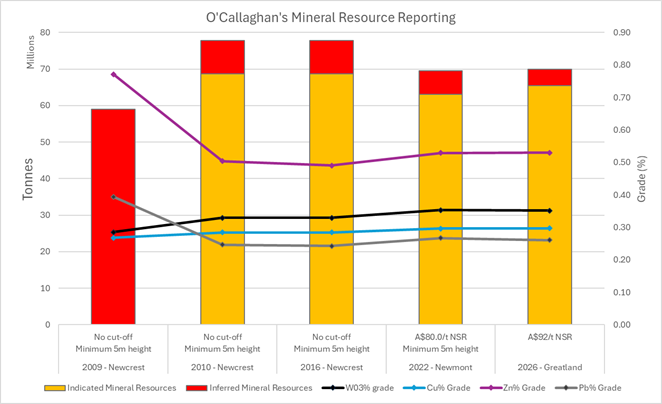
Comparison to Previous Mineral Resources
The O'Callaghans Mineral Resources has previously been reported as a Mineral Resource by both Newcrest Mining Limited and then Newmont Corporation between 2010 and 2023. It was not included by Greatland in its December 2024 MRE as a technical evaluation was ongoing at that time. With this work now complete it is the view of the Competent Person that the underlying data and relevant estimation support Greatland reporting a Mineral Resource estimate for the O'Callaghan deposit.
Figure 4 provides a comparison between previous reported Mineral Resources for the O'Callaghans Deposit.
Figure 4: Comparison with previous Mineral Resource estimates
. 
Forward Looking Statements
This document includes forward looking statements and forward looking information within the meaning of securities laws of applicable jurisdictions. Forward looking statements can generally be identified by the use of words such as "may", "will", "expect", "intend", "plan", "estimate", "anticipate", "believe", "continue", "objectives", "targets", "outlook" and "guidance", or other similar words and may include, without limitation, statements regarding estimated reserves and resources, certain plans, strategies, aspirations and objectives of management, anticipated production, study or construction dates, expected costs, cash flow or production outputs and anticipated productive lives of projects and mines.
These forward looking statements involve known and unknown risks, uncertainties and other factors that may cause actual results, performance and achievements or industry results to differ materially from any future results, performance or achievements, or industry results, expressed or implied by these forward-looking statements. Relevant factors may include, but are not limited to, changes in commodity prices, foreign exchange fluctuations and general economic conditions, increased costs and demand for production inputs, the speculative nature of exploration and project development, including the risks of obtaining necessary licences and permits and diminishing quantities or grades of reserves, political and social risks, changes to the regulatory framework within which Greatland operates or may in the future operate, environmental conditions including extreme weather conditions, recruitment and retention of personnel, industrial relations issues and litigation.
Forward looking statements are based on assumptions as to the financial, market, regulatory and other relevant environments that will exist and affect Greatland's business and operations in the future. Greatland does not give any assurance that the assumptions will prove to be correct. There may be other factors that could cause actual results or events not to be as anticipated, and many events are beyond the reasonable control of Greatland. Forward looking statements in this document speak only at the date of issue. Greatland does not undertake any obligation to update or revise any of the forward looking statements or to advise of any change in assumptions on which any such statement is based.
Competent Person Statement
The information in this announcement pertaining to estimation and reporting of the Mineral Resource estimates is based on, and fairly reflects, information and supporting documentation compiled under the supervision of Michael Thomson, Principal Geologist at Greatland. Mr Thomson is a full-time employee of the Greatland Group and has a financial interest in the Company. Mr Thomson is a member of the Australian Institute of Geology (AIG) and has over 20 years' relevant industry experience. Mr Thomson has sufficient experience that is relevant to the style of mineralisation and type of deposits under consideration and to the activity currently being undertaken to qualify as a Competent Person as defined in the 2012 Edition of the 'Australasian Code for Reporting Exploration Results, Mineral Resources and Ore Reserves'. Mr Thomson consents to the inclusion in this announcement of the matters based on that information and supporting documentation in the form and context in which it appears.
Independent consulting group SRK Consulting (Australasia) Pty Ltd (SRK) has reviewed the O'Callaghans Mineral Resource and is of the opinion that the supporting geological dataset and the geological and estimation methodologies used to the produce the Mineral Resource Estimate are reasonable and appropriate for the style of mineralisation of the deposit. Further, SRK considers that the Mineral Resources have been classified and reported in accordance with the guidelines and principals outlined in the 2012 edition of the Australasian Code for the Reporting of Exploration Results, Mineral Resources and Ore Reserves (JORC Code, 2012 edition).
Appendix 1: JORC Tables
JORC Code, 2012 Edition - Table 1 Section 1: Sampling Techniques and Data
|
Criteria |
Commentary |
|
Sampling techniques |
Drilling was undertaken using a combination of reverse circulation (RC) and diamond (DD). Recent programmes have largely used mixed ICP-OES/ICP-MS with aqua regia AAS for gold and silver and ion-specific electrode for fluorine. The significance of tungsten in the mineralisation mandated the use of alkaline peroxide fusion although aqua regia and four-acid digests have also been used. Aqua regia digests may be considered to be strong partial digest; four-acid digests are total for many elements but only near-total for tungsten. Alkaline peroxide fusion is a total digestion technique and is appropriate where wolframite is present. |
|
Drilling techniques |
The drilling pattern covers about 100 m by 100 m for the highest-grade part of the deposit increasing to a nominal 200 m by 200 m spaced pattern. A small part of the deposit was infilled to a 50 m by 50 m spacing to evaluate short-range grade continuity. The estimate used data from 184 drill holes including wedge holes for a total of 71,700 m drilled. · 7 holes drilled in 1985. · 1 hole drilled in 1991. · 19 holes drilled in 2008. · 157 holes drilled in 2009. |
|
Drill sample recovery |
Diamond core recovery was systematically recorded in the geological database for 15 holes from the 2008 and 2009 programmes. Core recovery in the mineralised skarn is typically very good. There is likely no impact from core recovery on the Mineral Resource estimate quality. There is no record of RC sample recovery but very little of the recent RC drill samples were analysed and early RC drill holes were pre-collars for diamond drilling, so weren't designed to hit mineralisation. |
|
Logging |
DD and RC holes were geologically logged for lithology, alteration, mineralisation, veining, vein percentage, and structure. Logging information was recorded and validated prior to merging into the database. All drill core was photographed, either using conventional slide film or a digital camera, prior to cutting the core for sampling. Core from mineralized zones encountered in the 2009 drilling was examined with a high-powered shortwave ultraviolet lamp to estimate scheelite abundance. The fluorescent response of the lamped core was systematically photographed. All diamond holes from 2008-09 programmes have been subject to geotechnical logging. The logging detail is considered appropriate to support the nature of the O'Callaghans mineralisation and suitable for input into resource estimation. |
|
Sub-sampling techniques and sample preparation |
RC drilling samples were generally collected at 1 m intervals and split using a 1 in 8 riffle splitter or a rotary splitting device attached to the drill rig cyclone. The splitter produced a bulk reject that was bagged (numbered) into plastic bags and stored temporarily for reference and logging. The primary split is between 2 kg to 5 kg. All of the primary assay samples were collected into a calico bag and placed inside the bulk reject plastic bag for identification. DD core sampling follows a detailed protocol to maximize sampling precision. Mineralized and important lithological contacts are used as sample boundaries. Diamond core was cut and half core samples collected. The 2008 and 2009 drilling constitute the vast bulk of the data. Samples from the 2008 program were cut and prepared at Telfer and the pulps shipped to a commercial laboratory in Perth. In the 2009 program full core samples were shipped to Perth in their core trays. Cutting and sample preparation took place on the laboratory's premises. Minimum and maximum sample intervals are 20 cm and 1 m respectively. Diamond core samples are crushed to nominal 95% passing 2 mm and half split collected by rotary sampling device. The entire split is pulverized (nominal 95% passing 75 \u03bcm tested at a rate of 1 in 25) in an LM5 mill. A 250 g assay subsample is taken by a scoop. This protocol is considered appropriate for the mineralisation style. RC samples for assay are crushed to nominal 95% passing 2 mm and split to a maximum of 3 kg, all of which is pulverized in the LM5. This protocol is also considered appropriate for the mineralisation style. Field duplicates of RC drilling were collected at the rate of 5% Coarse duplicates (from the crusher) were taken for diamond core samples, also at the rate of about 5% No second half core analyses were carried out due to the need to preserve as much core as possible for metallurgical test work |
|
Quality of assay data and laboratory tests |
With very few exceptions, O'Callaghans samples were analysed at independent commercial laboratories. There has been a wide range of elements determined over the life of the prospect. Similarly, a wide variety of analytical methods have been used. Early programs determined most elements by AAS with pressed powder XRF, fire assay, and colorimetry being used where appropriate. Recent programmes have largely used mixed ICP-OES/ICP-MS with aqua regia AAS for gold and silver and ion-specific electrode for fluorine. The significance of tungsten in the mineralisation mandated the use of alkaline peroxide fusion although aqua regia and four-acid digests have also been used. Aqua regia digests may be considered to be strong partial digest; four-acid digests are total for many elements but only near-total for tungsten. Alkaline peroxide fusion is a total digestion technique and is appropriate where wolframite is present. Drilling at O'Callaghans up to 1996 was not supported by QAQC protocols. Drilling programmes in 2008 and 2009 (which make up more than 90% of the diamond drilling) were accompanied by QAQC protocols that included certified reference materials (CRM) including primary tungsten reference materials from Canmet, blanks, second laboratory checks, coarse duplicates, pulp duplicates, and umpire analyses. Accuracy has been monitored through: · CRMs at a submission rate of approximately one in ten. · Laboratory standards at a rate of one in twenty. Tungsten median bias for CRMs above 750 ppm W (including the three primary CRMs) is -1.1%. Copper bias is +0.5% and zinc +1.7%. Lead bias is zero for all data and -0.2 for CRMs above 1000 ppm lead. None of the bias figures suggest any issues. Blank results are generally as expected with the highest reported assays above detection limits for (all these results are less than ten times detection limit). |
|
Verification of sampling and assaying |
Detailed procedure for data collection and collation which includes hole naming, logging, collection of sample material for assay, receipt of assay results, drill hole collar pickup, downhole survey, and data QAQC. The database has automatic validation checks, with all data validation protocols overseen by centralized database team. The validation process is multi-staged, requiring input from geologists, surveyors, and assay laboratories. Details of sampling were recorded digitally using a handheld barcoding system. All samples recorded as missing were coded and checks carried out for overlaps or gaps in the samples. Internal data quality reviews were conducted by site teams and resource personnel prior to resource estimation. No twin holes have been drilled. There has been no adjustment to assay data. Where re-assay has shown earlier assays to be erroneous both sets of data are stored in the database with a comment to indicate the authority by which the second set has been added. |
|
Location of data points |
Surface drill rigs are positioned using surveyed collar pegs and lined up using compass lines. The dip of each hole is established using an inclinometer. Drill hole collars were surveyed by mine surveyors on completion of the drill hole. Several different downhole survey methods were utilized at O'Callaghans during previous exploration phases. Most recently, drill holes were downhole surveyed on completion using a Miniature Multi-shot Tool or gyroscopic tool at between 10 m and 30 m intervals. A local mine grid, Telfer Mine Grid 2002, covers the whole of the Telfer mine area. It is oriented with grid north at 44o west of magnetic north. The grid was established with several accurately defined datums. The Telfer region natural surface topography is based on surface surveys (LIDAR) prior to the commencement of mining. |
|
Data spacing and distribution |
The drilling pattern is approximately 100 m by 100 m for the highest-grade part of the deposit widening to a nominal 200 m by 200 m spaced pattern outside the known high grade. A small part of the deposit was infilled to a 50 m by 50 m spacing to evaluate short-range grade continuity. The estimate used data from 184 drill holes including wedge holes for a total of 71,700 m drilled. |
|
Orientation of data in relation to geological structure |
Surface drilling is orientated vertically to sub-vertical to ensure optimal intersection angle for the flat-lying mineralisation. Acceptable intersection angles are considered during the drill hole planning process. No orientation bias has been indicated in the drilling data to date. |
|
Sample security |
The security of samples is controlled by tracking samples from the drill rig to the database. RC samples were collected and barcoded. Barcoding involves attaching plastic tags with a barcode and number to the calico bag. The process was established with a series of checks to ensure that all samples were collected and all appropriate barcodes attached to bags. The barcoded calico bags were collected and delivered to the analytical laboratory. The RC procedure also applied to diamond drill holes in the 2008 programme but in 2009 whole core was freighted to Perth for cutting and preparation at the laboratory. The core was shipped in trays that minimized the relative movement of core pieces. The trays were packed and sealed to be tamper-evident. Any discrepancy between the packing list and the samples delivered was notified immediately to the site. Details of all sample movements are recorded in a database table. Dates, BHID, sample ranges, and the analytical suite requested are recorded with the dispatch of samples to analytical services. Any discrepancies logged at the receipt of samples into the analytical services are validated. Data was entered into the database directly from the laboratory results file, i.e. there was no keying of assay results. |
|
Audits or reviews |
Internal data quality reviews are conducted by site teams and resource personnel prior to resource estimation. Site personnel carry out laboratory inspections during the 2009 programme sample logging, cutting, and preparation was carried out at the laboratory. An external independent third-party consultancy at regular intervals undertakes a review of the Mineral Resource estimation which includes a review of the input data. This was last completed by SRK Consulting in 2026. |
JORC Code, 2012 Edition - Table 1 Section 2: Reporting of Exploration Results
|
Criteria |
Commentary |
|
Mineral tenement and land tenure status |
The O'Callaghans poly-metallic deposit is located approximately 10 km south of Greatland's Telfer Gold Mine in Western Australia within approved mining lease ML45/203. |
|
Exploration done by other parties |
Geophysical exploration by Newmont Pty Ltd between 1972 and 1983 identified the presence of a granitoid in the O'Callaghans area. A high resolution ground magnetic survey was carried out over several airborne magnetic anomalies during 1984. Seven diamond drill holes were completed in 1985 to test discrete magnetic anomalies for possible skarn mineralisation associated with the granitoid. The drilling, together with deflation lag sampling and mapping, confirmed the presence of a zoned system of poly-metallic skarn mineralisation above the granitoid.
A grid of reverse circulation drill holes during the 1980s and 1990s failed to intersect the skarn mineralisation, although one deep drill hole in 1987 to the northwest of the main skarn intersected the granitoid contact. One diamond drill hole was drilled during 1991 that intersected thin skarn mineralisation. 19 diamond drill holes were completed during 2008 to further test the extent of skarn mineralisation and to infill the grid to 200 m in the main mineralized area. During 2009 and 2010, 157 diamond drill holes were completed to infill the grid to 100 m centres over the main mineralisation. |
|
Geology |
The O'Callaghans deposit is a polymetallic skarn deposit which lies at the contact between the Proterozoic Puntapunta Formation and the O'Callaghans granite. The Puntapunta Formation conformably lies between the Wilki Formation and the Telfer Formation and considered to be outer carbonate shelf deposits consisting of well-bedded, clastic dolomite and limestone, with lesser amounts of calcareous sandstone and siltstone. The O'Callaghans granite was identified at around 350 m below surface based on diamond drilling intercepts and geophysical surveys. Drilling defined a zone of poly-metallic skarn mineralisation up to 60 m thick above the granite/limestone contact. The O'Callaghans granite is variably altered and is not readily grouped with other regional granitic suites. The O'Callaghans granite is directly associated with complex skarn zones, including pyrite/pyrrhotite/magnetite skarns with a strong magnetic expression. It is the only granite known to be associated with extensive hydrothermal alteration systems and metal anomalies (W-Cu-Bi-Mo-Sn-Pb-Zn). Folded Puntapunta Formation sedimentary rocks appear to be overprinted by variable metamorphic alteration. Sulphide mineralisation related to high-temperature metasomatic skarn formation is consistent with a rapid onset of amphibolite facies contact metamorphic alteration of the host rocks (tremolite/hornblende + biotite). This forms an irregular metamorphic contact aureole above the O'Callaghans granite stock and is a valuable visual aid in recognizing onset and distribution of sulphide mineralisation. The skarn mineralisation and metamorphic aureole overlies a massive, sub-horizontal, poorly mineralized, quartz flooded zone, which in turn overlies weakly foliated granite. Contact with the granite is relatively sharp. The Main Skarn is identified as calc-silicate rock containing more than 10% sulphides generally surrounded by a halo of calc-silicates with less than 10% sulphides. Tungsten, copper, zinc and lead are considered potentially economically extractable. However elevated levels of molybdenum and silver are also present. Tungsten-bearing minerals include both scheelite and wolframite. Gold is not present in economically significant amounts. Fluorine levels show some elevated levels and range between 0.29% and 5.69%. Metal zoning is identified within the overall skarn with two areas of elevated zinc and lead broadly associated with a tungsten mineral species change from scheelite to wolframite. |
|
Drill hole Information |
Not applicable to the mineral resource estimate. |
|
Data aggregation methods |
Significant assay intercepts are reported using length-weighted averages based on predefined thresholds, with a maximum allowable internal dilution. For mineral resource estimates, data aggregation methods are aligned with sampling, drilling, and recovery techniques. No exploration results are included in this report, as it focuses on Mineral Resources. |
|
Relationship between mineralisation widths and intercept lengths |
No exploration has been reported in this release, therefore there are no relationships between mineralisation widths and intercept lengths to report. This section is not relevant to this report Mineral Resources. |
|
Diagrams |
As provided.
|
|
Balanced reporting |
Significant assay intervals represent apparent widths, as drilling is not always perpendicular to the dip of mineralisation. True widths are typically less than downhole widths and can only be estimated once all results are received and final geological interpretations are completed. No exploration results are included in this report, so relationships between mineralisation widths and intercept lengths are not applicable to the Ore Reserves and Mineral Resources report. |
|
Other substantive exploration data |
Not applicable to the mineral resource estimate. |
|
Further work |
Further work is planned to evaluate exploration opportunities that extend the known mineralisation and to improve confidence of the model. |
JORC Code, 2012 Edition - Table 1 Section 3: Estimation and Reporting of Mineral Resources
|
Criteria |
Commentary |
|
Database integrity |
Data is stored in a SQL Server database known as acQuire. Assay data and geological data are electronically loaded into acQuire. Regular reviews of data quality are conducted by site and corporate teams prior to resource estimation in addition to external reviews. Detailed data review was completed before the estimation of the deposits. Checks included validation of collar surveys against planned locations and downhole surveys consistency of hole path. Assays were reviewed and compared against observed mineralisation. Logging records were reviewed against core photographs as part of the interpretative geology compilation. All corrections were completed before final data extraction for input to the Mineral Resource estimation. |
|
Site visits |
The Competent Person for Telfer mineral resources regularly visits the site. |
|
Geological interpretation |
The O'Callaghans deposit is a polymetallic skarn deposit located at the contact between limestone of the Puntapunta Formation and an intrusive granite. The Main Skarn is identified as calc-silicate rock containing more than 10% sulphides generally surrounded by a halo of calc-silicates with less than 10% sulphides. Sectional strings and wireframes were constructed for lithology, oxidation and structure and lead/zinc metal zonation using all available drilling data. Domains are based on the lithological logging of drill holes and on assay grades for the lead/zinc metal zonation domains. All lithological domains were treated as hard boundaries. Metal zoning was identified within the overall skarn with two areas of elevated zinc and lead broadly associated with a tungsten mineral species change from scheelite to wolframite. To address the risk associated with uncontrolled smoothing of high-grade zinc and lead grades, two elevated lead zinc zones were identified and modelled and treated as hard domains within the main skarn. Thereby restricting the interpolation of Zn and Pb to the defined zones. The zones in the original 2011 grade model were updated in 2016. The original zones were considered simplistic and deterministic as they were created by vertical projection only of a visually interpreted contact. The 2016 model used implicit modelling including non-vertical contacts (full 3-dimensional resolution). Structure and oxidation domains were modelled but they have little influence on the resource estimate. The final estimation domains are the same domains which are represented in the geological interpretation with the exception of the Zn and Pb portions. |
|
Dimensions |
Flat disc-shaped orebody, the Main skarn extends 1.2 x 1km in plan and is up to 60m thick in the centre thinning out towards the flanks, 350m below surface. |
|
Estimation and modelling techniques |
All drill hole samples were composited to 2 m length. The residual from compositing were retained by rescaling the composite lengths to include them. As such the final composite lengths vary from 1.35 m to 2.4 m in the main skarn domain.
Top-cuts were determined based on a review of histograms and log probability plots for the domain composites. Top-cuts were applied to lead / zinc-rich domain, the lead /zinc poor domain and molybdenum. All lithological and grade domains are treated as hard boundaries. Domains were assigned and coded to the drill hole data and blockmodel. Grade estimation was performed using ordinary kriging. The Pb and Zn elements were re-modelled in 2016 in following recommendations from an external review. Estimation was performed for 16 elements: tungsten, copper, zinc, molybdenum, lead, silver, arsenic, gold, bismuth, cadmium, cobalt, fluorine, iron, sulphur, antimony and tin. Not all variables are estimated throughout the entire block model due to insufficient data. Tungsten, copper, zinc and lead only are reported for the Mineral Resource estimation. Block cells of 50 m x 50 m x 5 m in X, Y and Z were used to fill the boundaries of the domains. Sub-cells with a minimum of 10 m x 10 m x 5 m in X, Y and Z. The maximum block model cell size is equal to spacing in the most densely drilled sections and half the average drill spacing. A declustering analysis was conducted for the main elements. The declustering had little impact on the mean grades. A review of top cuts for the composites was conducted to manage risk and restrict the effect of outliers. Top cuts were determined based on a review of histograms and log probability plots for the domain composites. As the contact skarn mineralisation is dome-shaped over the top of the intrusive body, anisotropy search and variogram orientations were applied where each block model cell is assigned a bearing and plunge by Locally Varying Anisotropy (LVA). The initial search ellipse was oriented flat with an isotropic search in the plane for each element. This was then rotated by the applied LVA orientation. The dimensions for the search ellipse for all elements except Pb and Zn were 300 m in the plane of the skarn (x and y) and 40 m vertically. Pb and Zn were internally domained within the skarn horizon requiring customised search volumes ranging typically 200-250m (x & y) and 20-72m (z). A minimum of 9 and a maximum of 16 samples were required to estimate grades for all elements except Pb and Zn where minimum 9 and maximum 20 were applied. Discretisation for all domains was set at 5 by 5 by 5 (X, Y, Z). The wolframite mineral probability was estimated using indicator kriging. Tungsten is reported as part of the Mineral Resource as tungsten trioxide (WO3). The conversion was done by formula WO3=W x 1.2611 The final skarn grade estimates were validated visually against the input drill hole composites. Swath plots comparing model and sample data show an expected (smooth modelled vs. varied sample grades), correlation with no obvious bias. |
|
Moisture |
All tonnages are calculated and reported on a dry tonne basis. |
|
Cut-off parameters |
A specific cut-off grade was not used. Each block within the resource model is assigned a value based on an estimate of its net smelter return. Net smelter return is calculated on a payable metal basis taking into account metal prices, metallurgical recoveries, processing costs and realisation costs. Value / profit cut-off includes mining costs, processing costs with assigned sustaining capital and G&A components. The cost of grade cutoff applied to the Mineral Resource (NSR) is A$94. |
|
Mining factors or assumptions |
A 2014 Pre-feasibility Study was completed in 2014 for the O'Callaghans deposit. Underground mining methods examined were sub-level caving, trough caving, long-hole open stoping, and room and pillar. Long hole open stoping was selected as the optimum mining method due to the shape of the orebody and hydrological conditions. Materials handling options considered included truck, conveyor, shaft, and a combined shaft and haul. Trucking was selected as the optimum materials handling method due to simplicity, scalability, and low capital requirements. A NSR decline truck haulage with no ore sorting at NSR cutoff A$94. |
|
Metallurgical factors or assumptions |
The proposed process route involves a four-stage copper, lead, zinc, and pyrite sequential flotation, followed by a magnetic separation stage and finally gravity separation of tungstate concentrate. This will be through the current Telfer Mill Facility.
The metallurgical domains used to date are based on the pre-defined skarn domain and the separation of the lead-zinc rich and lead-zinc poor domains. Metallurgical test work has been completed on representative samples of both the lead-zinc rich and lead-zinc poor sub-domains. |
|
Environmental factors or assumptions |
Mining and ore processing operations at Telfer are conducted pursuant to a series of granted environmental and other approvals. |
|
Bulk density |
Bulk density values were determined from 914 measurements taken from 73 holes for the main geological domains using wet/dry weight calculations. Densities results were averaged for each domain and the average bulk density assigned to the appropriated block model domain. |
|
Classification |
The Mineral Resource estimate was classified as Indicated Mineral Resource where drill hole data is considered to be sufficient to demonstrate grade and geological continuity within the main mineralized horizon. For Indicated the drill holes are spaced at 100 m x 100 m in X and Y. The Inferred Mineral Resource occurs in a narrow halo around the Indicated Mineral Resource where the drill spacing transitions from 100 m to 200 m spaced holes and where there is enough drill hole data to demonstrate geological continuity but grade uncertainty increases in areas of wider drill hole spacing No metallurgical or geotechnical assumptions are incorporated in the Mineral Resource estimate. Block model cell size is restricted to a mining stope optimisation outline which coincides with mining assumptions for possible extraction long-hole open stoping technique. |
|
Audits or reviews. |
Multiple independent reviews have been carried out on the O'Callaghans MRE since 2010, with the most recent review completed in 2026 by SRK Consulting. |
|
Discussion of relative accuracy/ confidence |
For an Indicated Resource it is considered reasonable for the relative uncertainty to be +/- 15% in tonnage, grade, and metal (exclusive of each other, i.e., each variable has to satisfy the for an annual production volume at a 90% confidence level. Geostatistical evaluations of estimated grades indicate that these criteria can be satisfied. Inferred resources reflect the wide-spaced drilling where the Geological evidence is sufficient to imply but not verify geological and grade (or quality) continuity. |
Appendix 2: Tungsten Mineral Resource Estimate Benchmarking
|
Project |
Ownership |
Tonnage (Mt) |
Grade WO3 %) |
Contained Metal |
Link |
|
Hemerdon |
Tungsten West |
327 |
0.12% |
409 |
|
|
Northern Dancer |
Largo |
425 |
0.10% |
405 |
|
|
Mactung |
Fireweed Metals |
54 |
0.70% |
374 |
|
|
Sisson |
Northcliff Resources |
574 |
0.06% |
353 |
|
|
Mt Mulgine |
Tungsten Mining |
259 |
0.11% |
285 |
|
|
Sangdong |
Almonty Industries |
59 |
0.44% |
259 |
|
|
O'Callaghans |
Greatland Resources |
70 |
0.35% |
246 |
Per this announcement |
|
Nui Phao |
Masan High Tech Materials |
97 |
0.18% |
179 |
|
|
Dolphin |
Group 6 Metals |
11 |
0.91% |
103 |
|
|
Mt Carbine |
EQ Resources |
41 |
0.23% |
94 |
|
|
Watershed |
Tungsten Mining |
49 |
0.14% |
70 |
|
|
Panasqueira |
Almonty Industries |
15 |
0.23% |
34 |
|
|
Barruecopardo |
EQ Resources |
21 |
0.19% |
41 |
|
|
Pilot Mountain |
Guardian Metal |
13 |
0.27% |
34 |
|
|
Gentung Browns |
Almonty Industries |
8 |
0.32% |
24 |
|
|
Hatches Creek |
Tungsten Mining |
12 |
0.17% |
21 |
|
|
Valtreixal |
Almonty Industries |
18 |
0.11% |
19 |
|
|
Santa Comba |
Pivotal Metals |
10 |
0.16% |
16 |
|
|
Molyhill |
Tivan |
5 |
0.26% |
12 |
|
|
Los Santos |
Almonty Industries |
4 |
0.27% |
11 |
|
|
Springer |
Private Group |
2 |
0.48% |
10 |
|
|
Grey River |
Playfair Mining |
1 |
0.73% |
9 |
|
|
Wolfram Camp |
EQ Resources |
3 |
0.28% |
8 |
|
|
Currais Novos |
Largo |
4 |
0.11% |
5 |
RNS may use your IP address to confirm compliance with the terms and conditions, to analyse how you engage with the information contained in this communication, and to share such analysis on an anonymised basis with others as part of our commercial services. For further information about how RNS and the London Stock Exchange use the personal data you provide us, please see our Privacy Policy.

Latest directors dealings
- 6 hours ago Molten Ventures
- 7 hours ago National Grid
- 7 hours ago Origin Enterprises (CDI)
- 7 hours ago Computacenter
- 8 hours ago Norcros