
Uranium Intersected Along 2.9 km Of Paleochannel
Summary by AI BETAClose X

THIS ANNOUNCEMENT CONTAINS INSIDE INFORMATION FOR THE PURPOSES OF THE MARKET ABUSE REGULATION (EU) 596/2014 (AS AMENDED) AS IT FORMS PART OF THE DOMESTIC LAW OF THE UNITED KINGDOM BY VIRTUE OF THE EUROPEAN UNION (WITHDRAWAL) ACT 2018 (AS AMENDED). UPON PUBLICATION OF THIS ANNOUNCEMENT, THIS INSIDE INFORMATION IS NOW CONSIDERED TO BE IN THE PUBLIC DOMAIN.
12 October 2026
Arkle Resources PLC
("Arkle" or the "Company")
Uranium Intersected Along 2.9 km Of The Paleo East Channel
Near-Surface Mineralisation And Carnotite Confirmed Up-Drainage Of Trekkopje
Less Than A Quarter Of The Paleo East Channel Tested
Erongo Uranium Project, Namibia
Arkle Resources PLC (LSE:ARK), the energy metals explorer focused on uranium, is pleased to announce the results of the first phase of drilling at its paleochannel targets on EPL 8995, part of the Company's Erongo uranium project in Namibia, with assays from its primary ULG target to follow imminently.
Uranium mineralisation has been intersected on six of the ten drill fences across the Paleo East channel and in four step-out holes between them, over 2.9 km of the channel. All of the mineralised intervals begin within five metres of surface, and the best interval is 6 m at 102 parts per million (ppm) of uranium oxide (U₃O₈) from surface in hole R057.
The channels follow the regional palaeodrainage, the ancient river system that runs north-east to south-west through Arkle's ground and on to Orano's Trekkopje deposit about 10 km to the west, so they lie up-drainage of Trekkopje.
Highlights
· Uranium On Six Of Ten Fences Across The Paleo East Channel: mineralisation returned from twelve holes along 2.9 km of the channel, on six of the ten fences drilled across it and in four step-out holes between them.
· Mineralisation Starts At Surface: all twelve mineralised intervals begin within five metres of surface, the same setting in which the bulk of the mineralisation at Trekkopje occurs, with carnotite, the uranium mineral carrying the grade, visually logged in eight holes.
· Best Intervals: 6 m at 102 ppm U₃O₈ from surface in hole R057, including 4 m at 136 ppm U₃O₈ from 1 m; 3 m at 99 ppm U₃O₈ from 3 m in hole R003, including 1 m at 262 ppm U₃O₈ from 4 m; and 5 m at 72 ppm U₃O₈ from surface in hole R053, including 1 m at 139 ppm U₃O₈ from surface.
· The Same Drainage That Runs To Trekkopje: the interpreted channels trend north-east to south-west over 12.7 km and 10.5 km, running through Arkle's ground and down the same drainage to Orano's Trekkopje deposit 10 km away, which contains 340 Mt at about 120 ppm U₃O₈, most of it within 15 m of surface. The best Paleo East intervals, reported at a 40 ppm U₃O₈ lower cut, are of the same order in the same near-surface setting.
· Only 23% Of The Channel Drilled: the 2.9 km tested by wide-spaced drilling, at a median spacing of approximately 160 m between holes, represents under a quarter of the 12.7 km interpreted length of the Paleo East channel, leaving the majority open for follow-up.
· Further Paleochannel Targets Across The Licences: Paleo West, which has had only limited first-pass drilling and requires follow-up, and further paleochannel targets on EPL 8298 (Marenica South) and EPL 8290 (Trekkopje North) are analogous to Paleo East and will be worked through systematically, with new HLEM lines planned on EPL 8298.
Rory Harding, Chief Executive Officer, Commented:
"Six of the ten fences we drilled across the Paleo East channel returned uranium, along close to three kilometres of its length, and every one of the twelve mineralised intervals starts within five metres of surface. Carnotite is visible in eight holes from a metre below surface, and the best grade, 262 ppm in hole R003, sits only four metres down."
"The channels run north-east to south-west with the regional drainage, through our ground and on towards Trekkopje some ten kilometres away, and we have drilled a little under a quarter of the Paleo East channel so far. Calcrete deposits like Trekkopje are low-grade, bulk-tonnage systems in which the volume of near-surface channel fill matters as much as grade, so it is significant that all of the mineralisation we have found starts within five metres of surface."
"Drilling out paleochannels like these requires relatively close-spaced drilling over a wide area, but the purpose of this first wide-spaced programme was to confirm the extent of the mineralised channels and to guide our interpretation of the basement architecture. We are now recalibrating the channel-depth interpretation and designing infill drilling across the mineralised sections of the channel, and the results for the ULG target, approximately twelve kilometres to the west-southwest, will follow shortly. Beyond the Paleo East target, we have at least three further paleochannel targets across the licences, including on EPLs 8298 and 8290, which we plan to work through in the same way."
Next Steps
The Company's planned activity on the paleochannel targets through the remainder of 2026 includes:
· Recalibration of the channel-depth interpretation from the two HLEM lines crossing Paleo East, followed by the design of infill drilling across the mineralised sections of the channel and step-out drilling to test the remaining 9.8 km.
· Shallow trench sampling between mineralised drill holes on the Paleo East target, to identify infill drill positions, with follow-on trenching, mapping and sampling shortly to begin on the paleochannels and samples submitted for assay.
· First-pass geological interpretation of the paleochannel targets.
· Trench and surface mapping continues in the area to identify new drill sites, together with evaluation of additional ground and further geophysics, including new HLEM lines over the paleochannel targets on EPL 8298 (Marenica South).
· Review of the wider licence package against the airborne radiometric dataset, including ground where mineralisation may be only weakly expressed in surface radiometrics.
Figures
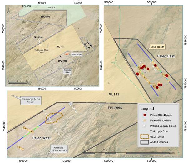
Figure 1: Paleo East and Paleo West targets on EPL 8995, showing drill collars, the 2026 HLEM lines and holes with assay intercepts above 40 ppm U₃O₈, reported as set out under Table 1.
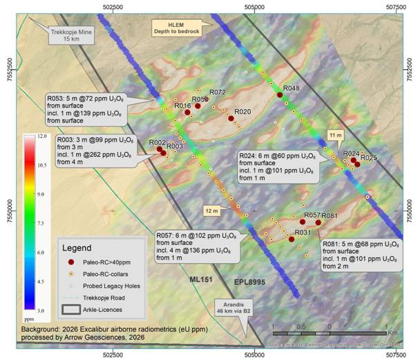
Figure 2: Paleo East target over the airborne radiometric image, showing HLEM depth-to-basement profiles, drill collars and best intervals at a 40 ppm U₃O₈ cut-off, reported as set out under Table 1.
Further Details
The first phase of paleochannel drilling has established the architecture of both channel systems and confirmed uranium mineralisation along the Paleo East channel. The channels trend north-east to south-west with the regional drainage, running through the target area, parallel to the main Trekkopje deposit trend, and are deeper than interpreted from the HLEM lines, increasing the interpreted volume of channel fill. Assay results for all 206 paleochannel samples are reported in this announcement.
Paleochannel Drilling Programme
The initial programme at the Paleo East and Paleo West targets comprised 1,558 m of RC drilling in 78 vertical holes on EPL 8995. The programme was completed at the end of July 2026 and formed part of the 2,712 m drilled across all three targets on the licence, as reported on 14 September 2026.
· Paleo East target: 1,390 m in 66 holes.
· Paleo West target: 168 m in 12 holes.
· All holes are shallow, at less than 30 m, terminating at least one metre into the basement metasediments.
· Drilled on ten fences across the interpreted channel positions at Paleo East and two at Paleo West, at a median nearest-neighbour spacing of approximately 160 m, with further step-out holes between the fences.
Eastern Paleochannel Target
Step-out holes were completed from the existing fences to test the interpreted channels along strike, their number, location and spacing designed by the Company's geological team with its consultants and informed by the geological logging and downhole spectrometry. Twenty-one holes yielded sufficient eU₃O₈ grades, above 40 ppm, to warrant sampling, accounting for 185 of the 206 samples assayed.
Mineralisation is distributed along the drilled extent of the channel rather than confined to one part of it. Uranium was returned on six of the ten fences completed across the channel and in four step-out holes drilled between them, from twelve holes in total spanning 2.9 km along the channel axis. Twelve mineralised intervals were returned, all of which begin within five metres of surface, and intervals of 2 m or more are reported in eleven holes. The best intervals are:
· Hole R057: 6 m at 102 ppm U₃O₈ from surface, including 4 m at 136 ppm U₃O₈ from 1 m.
· Hole R003: 3 m at 99 ppm U₃O₈ from 3 m, including 1 m at 262 ppm U₃O₈ from 4 m.
· Hole R053: 5 m at 72 ppm U₃O₈ from surface, including 1 m at 139 ppm U₃O₈ from surface.
· Hole R081: 5 m at 68 ppm U₃O₈ from surface, including 1 m at 101 ppm U₃O₈ from 2 m.
· Hole R024: 6 m at 60 ppm U₃O₈ from surface, including 1 m at 101 ppm U₃O₈ from 1 m.
· Hole R016: 3 m at 49 ppm U₃O₈ from surface.
· Hole R031: 2 m at 49 ppm U₃O₈ from 1 m.
The complete list of mineralised intervals is set out in Table 1.
|
Drill Hole |
From (m) |
To (m) |
Width (m) |
U₃O₈ (ppm) |
Grade width |
|
R002 |
3 |
5 |
2 |
45 |
90 |
|
R003 |
3 |
6 |
3 |
99 |
297 |
|
including |
4 |
5 |
1 |
262 |
262 |
|
R016 |
0 |
3 |
3 |
49 |
147 |
|
R020 |
1 |
3 |
2 |
41 |
82 |
|
R024 |
0 |
6 |
6 |
60 |
360 |
|
including |
1 |
2 |
1 |
101 |
101 |
|
R025 |
4 |
5 |
1 |
43 |
43 |
|
R031 |
1 |
3 |
2 |
49 |
98 |
|
R048 |
3 |
5 |
2 |
46 |
92 |
|
R053 |
0 |
5 |
5 |
72 |
360 |
|
including |
0 |
1 |
1 |
139 |
139 |
|
R057 |
0 |
6 |
6 |
102 |
612 |
|
including |
1 |
5 |
4 |
136 |
544 |
|
R072 |
1 |
4 |
3 |
41 |
123 |
|
R081 |
0 |
5 |
5 |
68 |
340 |
|
including |
2 |
3 |
1 |
101 |
101 |
Table 1: Paleo East target drill intercepts from laboratory assays of one-metre samples, all grades in ppm U₃O₈. Intercepts are reported at a 40 ppm U₃O₈ lower cut, with a 1 m minimum width, a maximum of 5 consecutive metres of internal dilution, up to 1 m of sub-cut-off shoulder at each end and a composite grade of at least 40 ppm U₃O₈; including intervals are reported at a 100 ppm U₃O₈ lower cut. Holes are vertical and the channel fill is interpreted as broadly horizontal, so downhole widths are considered to approximate true widths. The remaining sampled holes, including the three at Paleo West, returned no intercept meeting these criteria.
The 2.9 km of mineralised channel represents approximately 23 per cent of the 12.7 km interpreted length of the Paleo East channel array. Carnotite in calcrete systems is precipitated from groundwater and distributed erratically at the metre-scale, so deposits of this style are delineated on close-spaced grids. Infill drilling on a tighter spacing across the mineralised sections is the natural next step and is being planned, alongside step-out drilling to test the remaining 9.8 km of channel. Planning for the next phase of step-out and infill drilling is supported by shallow trenching across the local mineralised channels, which is due to begin shortly.
Western Paleochannel Target
The western paleochannel target lies approximately 15 km west-southwest of the initial drilling area on lower ground towards the central-west of the licence, some 2.5 km south-west of the ULG target, and was previously mapped by the Company's HLEM profiling supported by processed airborne radiometric data and surface mapping.
· Twelve holes drilled in two fences, one line of seven holes at 200 m spacing and one line of five holes at 100 m spacing.
· Drill lines cross the interpreted channel position at right angles, aligned on 330° bearing, all holes terminating at least one metre into basement metasediments.
· Three holes yielded sufficient eU₃O₈ grades to warrant sampling, 21 samples in total, the highest returning 31 ppm U₃O₈, below the 40 ppm reporting cut.
The Paleo West samples do not correspond with surface radiometric anomalies, and the target will be reassessed in the next phase of target generation.
Assay Sampling And Quality Control
All 78 paleochannel holes were surveyed by four-channel gamma-ray spectrometer probe, with the probe runs completed and processed by Terratec Geophysical Services. Downhole probe results are reported in 10-centimetre intervals and were composited by weighted mean to one-metre intervals and used to select assay intervals. Twenty-four holes were sampled on a 40 ppm eU₃O₈ cut-off, twenty-one at Paleo East and three at Paleo West.
· The 40 ppm cut-off was set deliberately low to ensure a broad sampling envelope in each hole, and the resulting proportion of assay data at lower grades will be used to refine the downhole GRS processing and its correlation to laboratory grades for future drilling.
· 206 samples submitted in total, 185 from Paleo East and 21 from Paleo West.
· 23 QAQC inserts submitted alongside them: 10 duplicates, 5 blanks and 8 certified reference materials, a rate of approximately 10 per cent.
· Multi-element (48 elements) assay by ICP-MS at Activation Laboratories, Ancaster, Ontario, Canada, with sample preparation at the Windhoek facility in Namibia.
· Blanks returned less than 1 ppm U, and repeat analyses of the three certified reference materials agreed to within approximately 4 per cent.
Paleochannel Lithology And Mineralisation
The paleochannel holes intersected a cover sequence of alluvium, conglomerate and muddy conglomerate overlying basement metasediments, with 1,236 m of the 1,559 m logged falling within the cover sequence. Carbonate cementation is widespread, which is characteristic of the calcrete-hosted deposits of the region.
· A moderate to strong reaction to dilute hydrochloric acid recorded over 746 one-metre drill chip intervals, across 70 of the 78 holes.
· Calcite is recognised in 1,305 one-metre intervals and gypsum in 70 intervals.
· Carnotite is visually logged in eight paleochannel holes across eight separate intervals at downhole depths of between 1 m and 22 m, extending the six holes reported on 14 September 2026. All visible carnotite is limited to the Paleo East target holes.
Visual observations of mineralisation are a weak proxy for uranium grade, and their absence does not necessarily preclude a sample from containing uranium mineralisation; laboratory assay is required to determine uranium content.
Deposit Style And Regional Analogues
The paleochannel targets are surficial, calcrete-hosted uranium systems in which carnotite is precipitated in channel-fill sediments at and near surface. Deposits of this style are characteristically low grade and high tonnage and are mined from surface at low strip ratios, so the economics rest on the volume of near-surface channel fill rather than on grade.
The interpreted channels on EPL 8995 trend north-east to south-west over 12.7 km and 10.5 km respectively, consistent with the regional palaeodrainage running from the granitic hinterland towards the Atlantic; the drainage area is interpreted to include the Spitzkoppe monzogranite and contemporaneous alkali intrusives. These are the same drainage systems that run through the Company's target area and on towards the Trekkopje deposit, some 10 km away.
· The uranium in the region's calcrete deposits is generally interpreted to have derived from granitic rocks traversed by the palaeodrainages, well upstream of the depositional sites.
· Orano's Trekkopje deposit contains 340 Mt grading 120 ppm U₃O₈, with mineralisation principally within 15 m of surface, over an area of approximately 16 km by 1 to 3 km, and produced its first uranium concentrate in 2011 before being placed on care and maintenance.
· Elevate Uranium's (ASX: EL8) Marenica deposit, 30 km north of Trekkopje in the same palaeochannel system, was previously reported at a grade of about 93 ppm U₃O₈ at a 50 ppm U₃O₈ cut-off. A re-estimate in February 2026, following a re-analysis of the historical drilling, gave 124 ppm U₃O₈ at the same 50 ppm cut-off, and after infill drilling the deposit now stands at 52.8 Mlb U₃O₈ at 180 ppm U₃O₈ at a 100 ppm U₃O₈ cut-off (Elevate Uranium, February and June 2026).
The comparisons above are to deposit style, geological setting and grade only; drill sample grades are not directly comparable with the grade of a Mineral Resource, the comparisons do not imply similar tonnage or economic potential, and no Mineral Resource has been estimated on any of Arkle's licences.
Uranium grades reported in this announcement are laboratory assay results from Activation Laboratories unless stated otherwise. Downhole gamma ray spectrometry results, where referred to, are estimates of uranium content derived from downhole geophysical measurement and are not substitutes for chemical assay results. The drilling reported here is first-pass exploration drilling. No Mineral Resource has been estimated on any of Arkle's licences, and no conclusions should be drawn as to the grade, tonnage, continuity or economic potential of mineralisation beyond the intervals reported. Assay results from the ULG drilling will be reported shortly.
Enquiries:
|
Arkle Resources Rory Harding, CEO John Teeling, Chairman |
+44 (0)20 3051 5348 +353 (0)1 833 2833 |
|
Strand Hanson Limited Ritchie Balmer / Imogen Ellis |
Nominated & Financial Adviser +44 (0)20 7409 3494 |
|
H&P Advisory Limited Andrew Chubb / Leif Powis |
Joint Broker +44 (0)20 7907 8500 |
|
First Equity Limited Jason Robertson |
Joint Broker +44 (0)20 7374 2212 |
|
Vigo Consulting Ben Simons / George Pope |
UK Media & IR +44 (0)20 7390 0234 arkle.ir@vigoconsulting.com |
|
Teneo Luke Hogg / Molly Mooney |
Ireland Media +353 (0)1 661 4055 |
About Arkle Resources
Arkle Resources PLC (AIM: ARK) is a multi-commodity exploration company focused on metals which are essential for the generation and storage of clean energy: uranium, lithium and zinc. Its projects are in tier-1 mining jurisdictions in Namibia, Botswana and Ireland, adjacent to world-class deposits.
Founded in 2004 by John Teeling and Jim Finn, the Company co-discovered the Stonepark zinc deposit in County Limerick, now Ireland's second largest undeveloped resource, in joint venture with Teck Ireland. Teck's interest was acquired by Group Eleven Resources (TSX-V: ZNG), who continue to advance the project alongside Arkle.
In January 2026, the Company announced a transformative deal to acquire Namibia Uranium Pty Ltd, which has introduced four highly prospective uranium licences contiguous to major producing and development assets in what is a world-class uranium jurisdiction. This acquisition, alongside the Company's existing licence portfolio and the introduction of new management, repositions Arkle to become a leading explorer in energy metals.
For more information visit: www.arkleresources.com
Follow us on social media:
www.linkedin.com/company/arkle-resources-plc
Qualified Person Review
The technical and scientific information contained in this announcement has been reviewed and approved by Dr Guy Freemantle, an independent consultant to the Company through The MSA Group (Pty) Ltd., Johannesburg, South Africa. Dr Freemantle holds a Bachelor of Science in Geology and a PhD in Geology, both at the University of the Witwatersrand. He is a member of the Society of Economic Geologists (892905) and current Vice President for the Africa Region; a Fellow of the Geological Society of South Africa (965392); and is registered with SACNASP (Registration 117527). Dr Freemantle has practised his profession continuously for 16 years and has sufficient experience and knowledge that is relevant to the style of mineralisation and type of deposits under consideration as well as to the activity that is being undertaken to fulfil requirements of a Qualified Person as per NI 43-101 / PERC Reporting Standard (2021). Dr Freemantle consents to the inclusion in this announcement of the technical and scientific information in the form and context in which it appears.
Glossary
|
EPL |
Exclusive Prospecting Licence |
|
eU₃O₈ |
Equivalent U₃O₈, estimated from downhole gamma ray spectrometry |
|
GRS |
Gamma Ray Spectrometry |
|
HLEM |
Horizontal Loop Electromagnetic |
|
ICP |
Inductively Coupled Plasma, the laboratory method (optical emission and mass spectrometry) used to assay the samples |
|
ppm |
Parts per million by weight; for example, 100 ppm U₃O₈ means 100 parts of U₃O₈ in every million parts of rock, equivalent to 100 grams per tonne |
|
QAQC |
Quality Assurance and Quality Control |
|
RC |
Reverse Circulation |
|
U₃O₈ |
Triuranium octoxide, the uranium oxide in which uranium grades and resources are conventionally reported and in which uranium is traded, commonly as the concentrate known as yellowcake |
|
ULG |
Uraniferous Leucogranite |
RNS may use your IP address to confirm compliance with the terms and conditions, to analyse how you engage with the information contained in this communication, and to share such analysis on an anonymised basis with others as part of our commercial services. For further information about how RNS and the London Stock Exchange use the personal data you provide us, please see our Privacy Policy.

Latest directors dealings
- 2 hours ago Diageo
- 2 hours ago Sanderson Design Group
- 3 hours ago Panthera Resources
- 4 hours ago Crest Nicholson Holdings
- 4 hours ago Informa