JORC Compliant Exploration Target - Mushima North
Summary by AI BETAClose X

("Tertiary" or the "Company")
30 March 2026
JORC Compliant Exploration Target at the Mushima North Project, Zambia
Tertiary Minerals plc (AIM: TYM) is pleased to announce an Exploration Target for Target A1 at its Mushima North Project in Zambia ("Mushima North" or the "Project") which is reported in accordance with the Joint Ore Reserve Committee ("JORC") Code (2012 Edition).
Mushima North is located in the prospective Iron-Oxide-Copper-Gold region of Zambia. Target A1 is a polymetallic, silver-copper-zinc prospect located 28km to the east of the historic Kalengwa Copper-Silver mine which is currently under redevelopment. Target A1 is one of several targets at Mushima North that are deemed by the Company to warrant further evaluation.
Highlights:
Ø JORC (2012) Exploration Target of 15 to 30 Mt at an average grade of between 40 g/t and 60 g/t silver equivalent*.
Ø The Exploration Target remains open to the northwest, southwest and at depth.
Ø Several other drill-ready targets exist within a 12km radius of Target A1 that remain untested.
Ø Planned follow-up work includes additional drilling of the Exploration Target to enable the reporting of a maiden Mineral Resources Estimate, if justified, by the end of 2026 and to test the continuation of mineralisation both along strike and at depth.
*The Exploration target has been prepared in accordance with JORC Code (2012). It should be noted that the potential quantity and grade is conceptual in nature, that there has been insufficient exploration to estimate a Mineral Resource and that it is uncertain if further exploration will result in the estimation of a Mineral Resource.
Richard Belcher, Managing Director of Tertiary Minerals plc, commented:
"We are delighted to report an Exploration Target for Target A1 on the Mushima North Project, marking a significant milestone for the Company on its projects in Zambia. The target provides an upper estimated range of potentially up to 58 million ounces silver equivalent and validates our focus on advancing this exciting new discovery.
The definition of the JORC (2012) Exploration Target has provided valuable information on the possible future resource potential of Target A1, which remains open to the northwest, southwest and at depth. The modelling will be used to support the planning of the upcoming drill programme with the aim of reporting a Maiden Mineral Resource Estimate by the end of 2026.
"These are exciting times for the Company as we continue to advance our project portfolio to deliver value to our shareholders. I look forward to providing further updates in due course."
JORC (2012) Exploration Target
The Exploration Target has been reported in accordance with the requirements for such set out in the 2012 Edition of the JORC Code and has been prepared to provide preliminary indications of the potential scale and grade of mineralisation at Target A1 only. The Exploration Target is 15 to 30 Mt at an average grade of between 40 g/t and 60 g/t silver equivalent ("AgEq") (Table 1).
Table 1. Exploration Target for Target A1, Mushima North Project.
|
|
Tonnage Range (Mt) |
Grade Range (AgEq g/t) |
|
Lower Limit |
15 |
40 |
|
Upper Limit |
30 |
60 |
Notes to Table 1
· The potential quantity and average grade of the near mine Exploration Target is conceptual in nature, there is insufficient data to estimate a Mineral Resource and it is uncertain if further exploration will result in the definition of a Mineral Resource.
· No economic parameters, mining dilution or recovery factors have been applied to the assessments of tonnes and average grade.
· All figures are rounded to reflect the inherent uncertainty and relative accuracy of the estimate.
· Infill drilling is planned this year to advanced the understanding and reduce the uncertainty around the grade variation and continuity and, if successful and appropriate, to enable the reporting of a Mineral Resource.
· Mt = million tonne; g/t = grammes per tonne.
The methodology and key assumptions made in deriving the Exploration Target are:
· The mineralisation has been modelled as a tabular flat-lying body some 500m long and 300m wide and up to 75m thick. An AgEq lower cut-off of 25 g/t was used to constrain the modelled mineralisation.
· The mineralisation contains potentially economic values of silver, copper and zinc and as such is reported as a silver equivalent value to incorporate the copper and zinc as well as the silver content of the mineralisation.
· Prior to any interpolation a top cut was applied to the outlying grades based on statistical analysis of the assay data. The following values were applied: Ag: 116 g/t; Cu: 0.8%, and Zn: 1%.
· The available drillhole assay results were interpolated into a 3D block model which encompassed the geological model and estimates undertaken for Ag, Cu and Zn by both Nearest Neighbour and Inverse Distance Squared Methods.
· The estimated block grades for Ag, Cu and Zn were then used to calculate an in-situ AgEq value on a block by block basis.
· A tonnage and grade was reported from the block model which was then flexed to provide a range of tonnage and average grade appropriate for Exploration Target reporting in accordance with the JORC (2012) code.
· Metallurgical testwork is planned but no work has been undertaken to date, as such no metallurgical factors were applied to the AgEq calculation. The metal price assumptions used for the AgEq calculation were: Ag: US$75/oz; Cu: US$ 5.8/lb, and Zn: US$ 1.45/lb. This resulted in a AgEq calculation of: AgEq g/t = Ag g/t + (48.38 x Cu%) + (12.1 x Zn%).
The current geological interpretation is that the mineralisation drilled to date comprises a near-surface, flat-lying secondary supergene (oxide) zone. Given the early stage of the Project and the broad drill spacing, several areas exist for the potential extension of the currently modelled mineralisation, including to the northwest, southwest and at depth. In addition, the primary source of the mineralisation is undefined at this stage.
The Exploration Target only considers Target A1 and does not consider the potential of nearby targets identified by the Company within the Mushima North Project, which show many of the same characteristics as Target A1 and that also warrant drill testing.
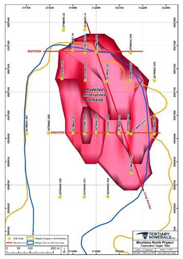 |
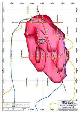
Figure 1. 3D geological model of Target A1 used as part of the Exploration Target located at the northern end of the copper-in-soil anomaly, Mushima North Project. See notes to Table 1 for further information.
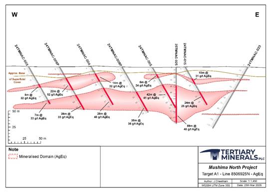
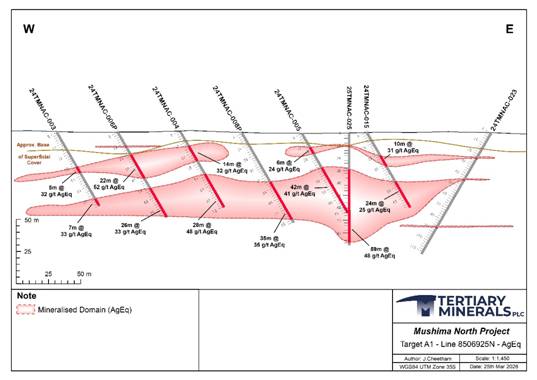
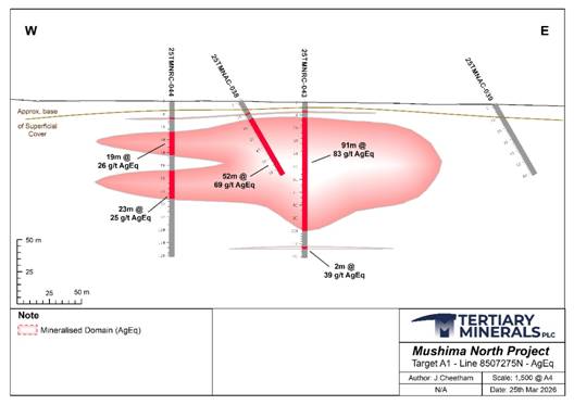
Figure 2. Drill cross section 8506925N (location of Figure 1) showing the extent of the Exploration Target and AgEq intersections. See notes to Table 1 for further information.
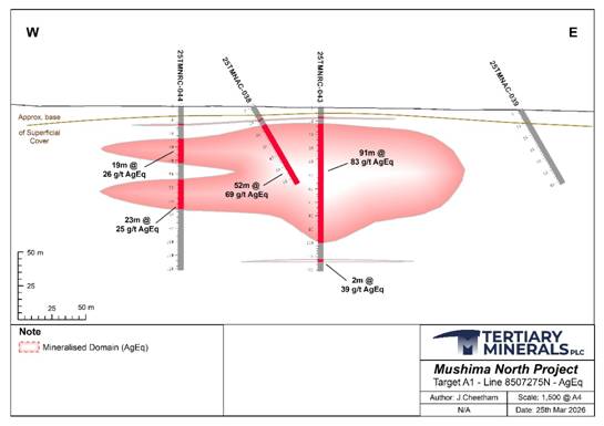
Figure 3. Drill cross section 8502725N (location of Figure 1) showing the extent of the Exploration Target and AgEq intersections. See notes to Table 1 for further information.
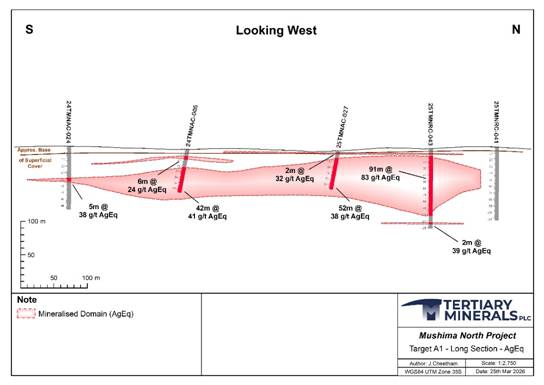
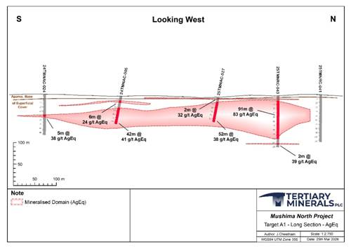
Figure 4. Long section (location of Figure 1) showing the extent of the Exploration Target and AgEq intersections. See notes to Table 1 for further information.
Next Steps
The Exploration Target provides valuable guidance on the potential of Target A1. The Company aims to build on the Exploration Target and undertake work to enable the reporting of a maiden Mineral Resource Estimate should this be justified and appropriate by the end of the year. To achieve this, the planned work will include:
· Further infill drilling to increase the geological confidence related to the modelling and estimation around grades and grade continuity.
· Metallurgical testwork to understand metallurgical characteristics and potential processing pathways and metal recoveries.
· Initial technical work to enable likely mining methods and plant and infrastructure requirements to be determined.
· Community support and environmental studies as part of the Company's Environmental, Social, Governance Policy and support the Project's long-term development plans.
Target A1 remains open both to the NW and SW and at depth, and there are also several drill-ready targets located within 12 km of Target A1 that also warrant drill testing.
Target A1
To date, three phases of percussion (air core and reverse circulation) drilling have been completed at Target A1 (Phase 1 in 2024:1,486m; Phase 2 in 2025: 1,116m; Phase 3 in 2025: 481m). Initial drilling targeted a copper-in-soil anomaly and returned broad but generally low-grade copper mineralisation as reported in the news release dated 28 October 2024 (e.g. 57m at 0.20% Cu from 14m downhole, hole 24TMNAC-004). Drilling over the associated silver- and zinc-in-soil anomaly, however, identified wide and thick, near-surface silver mineralisation (>10g/t Ag) associated with low-grade copper and/or zinc mineralisation.
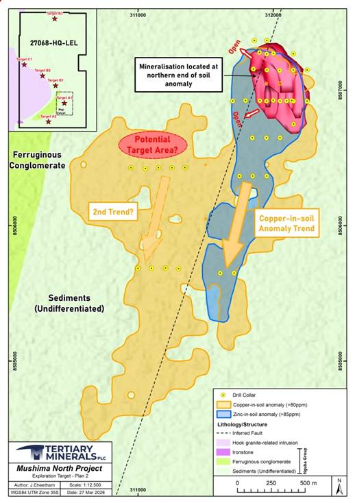 |
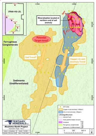
Figure 5. Location map of Target A1 showing soil sample results for copper and zinc, the collar locations of drilling, and the location of the Exploration Target. See notes to Table 1 for further information.
A summary of the Project is provided in the news release dated 9 October 2025. The best intersections to date (see news release dated 9 October and 4 February 2026) include (downhole, not true width):
· 97m at 56 g/t Ag & 0.43% Cu from 6m downhole,
o including: 13m at 77gt/ Ag, 1.46% Cu and 0.23% Zn from 84m downhole (25TMNRC-043).
· 73m at 32 g/t Ag, 0.16% Cu and 0.24% Zn from 11m downhole,
o including: 21m at 66 g/t Ag, 0.21% Cu and 0.3% Zn from 50m downhole (25TMNAC-025).
· 44m at 39 g/t Ag, 0.17% Cu and 0.37% Zn from 8m downhole, including:
o 15m at 63 g/t Ag, 0.13% Cu and 0.56% Zn from 33m downhole (25TMNAC-028).
The mineralisation at Target A1 is associated with a massive, haematitic and carbonaceous silty-sandy conglomerate. Copper, silver and zinc mineralisation, along with elevated bismuth (up to 991 g/t), and the critical metals antimony (up to 0.21%), cobalt (up to 2,960 g/t) and gallium (up to 40 g/t) are also associated with the mineralisation in places.
Mushima North Project
The Mushima North Copper Project (Licence 27068-HQ-LEL) is held through Group company Copernicus Minerals Limited ("Copernicus"), which is 90% owned by Tertiary Minerals (Zambia) Limited (itself 96% owned by Tertiary Minerals plc) and 10% by local partner, Mwashia Resources Limited.
The Project lies 20km to the east of the Kalengwa Copper-Silver mine, located in northwest Zambia, one of the highest-grade copper deposits ever to be mined in the country. In the 1970s, high-grade ore, average approximately 11% copper, was trucked for direct smelting at other mines in the Copperbelt. The Kalengwa mine is currently under redevelopment and is expected to produce 15,000 tonnes of copper annually.
Numerous other geochemical and/or geophysical targets (A2, B1, B2, B3, C2) are yet to be drill tested at Mushima North. Many of these are located within 12km of Target A1 (Figure 6).
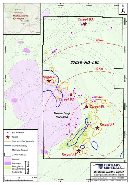 |
Figure 6. Geological map of the Mushima North Project showing the locations of the priority targets within the licence and their distance out from Target A1 based on 5 km radius rings.
Further Information:
|
Tertiary Minerals plc |
|
|
Richard Belcher, Managing Director |
+44 (0) 1625 838 679 |
|
SP Angel Corporate Finance LLP, Nominated Adviser and Broker |
|
|
Richard Morrison/Carline Rowe |
+44 (0) 203 470 0470 |
|
AlbR Capital Limited, Joint Broker |
|
|
Lucy Williams/Duncan Vasey |
+44 (0) 207 469 0930 |
Market Abuse Regulation
The information contained within this announcement is deemed by the Company to constitute inside information as stipulated under the Market Abuse Regulation (EU) No. 596/2014 as it forms part of UK domestic law by virtue of the European Union (Withdrawal) Act 2018 ('MAR'). Upon the publication of this announcement via Regulatory Information Service ('RIS'), this inside information is now considered to be in the public domain.
Cautionary Note Regarding Forward-Looking Statements
The news release may contain certain statements and expressions of belief, expectation or opinion which are forward looking statements, and which relate, inter alia, to the Company's proposed strategy, plans and objectives or to the expectations or intentions of the Company's directors. Such forward-looking statements involve known and unknown risks, uncertainties, and other important factors beyond the control of the Company that could cause the actual performance or achievements of the Company to be materially different from such forward-looking statements. Accordingly, you should not rely on any forward-looking statements and, save as required by the AIM Rules for Companies or by law, the Company does not accept any obligation to disseminate any updates or revisions to such forward-looking statements.
Competent Persons Statement
The Exploration Target was produced by Mr James McFarlane (BSc (Hons), MSc, MCSM, CGeol FGS, FNEIMME, CEng QMR FIMMM, RPGeo MAIG, FIQ.), associate Principal Consultant (Mining and Geology) with Bara Consulting. Mr McFarlane is an independent consultant to Tertiary and is a qualified person for the purposes of the AIM Note for Mining and Oil & Gas Companies. Mr McFarlane also has sufficient experience relevant to the style of mineralisation and type of deposit under consideration, and to the activity which he is undertaking to qualify as a Competent Person as defined by the 2012 Edition of the Australasian Code for Reporting of Exploration Results, Mineral Resources and Ore Reserves (the JORC Code). Mr McFarlane is a Fellow and Chartered Geologist with the Geological Society of London (CGeol FGS), a Chartered Engineer (CEng) and Fellow of the Institute of Materials, Minerals and Mining (FIMMM). Mr McFarlane has reviewed the information relating to the Exploration Target and consents to its inclusion in this release
The technical information in this release has been compiled and reviewed by Dr. Richard Belcher (BSc (Hons), PhD, CGeol FGS, EurGeol) who is a qualified person for the purposes of the AIM Note for Mining and Oil & Gas Companies. Dr. Belcher is a chartered fellow of the Geological Society of London and holds the European Geologist title with the European Federation of Geologists.
About Tertiary Minerals plc
Tertiary Minerals plc (AIM: TYM) is an AIM-traded mineral exploration and development company whose strategic focus is on energy transition metals. The Company's projects are all located in stable and democratic, geologically prospective, mining-friendly jurisdictions. Tertiary's current principal activities are the discovery and development of copper and precious metal mineral resources in Zambia and Nevada, USA.
Appendix A: JORC Code, 2012 Edition - Table 1 for Mushima North Project
Section 1 Sampling Techniques and Data
(Criteria in this section apply to all succeeding sections.)
|
Criteria |
JORC Code explanation |
Commentary |
|
Sampling techniques |
· Nature and quality of sampling (eg cut channels, random chips, or specific specialised industry standard measurement tools appropriate to the minerals under investigation, such as down hole gamma sondes, or handheld XRF instruments, etc). These examples should not be taken as limiting the broad meaning of sampling. · Include reference to measures taken to ensure sample representivity and the appropriate calibration of any measurement tools or systems used. · Aspects of the determination of mineralisation that are Material to the Public Report. · In cases where 'industry standard' work has been done this would be relatively simple (eg 'reverse circulation drilling was used to obtain 1 m samples from which 3 kg was pulverised to produce a 30 g charge for fire assay'). In other cases more explanation may be required, such as where there is coarse gold that has inherent sampling problems. Unusual commodities or mineralisation types (eg submarine nodules) may warrant disclosure of detailed information. |
· Exploration is of a reconnaissance and early evaluation stage commensurate with the stage of the project and surrounding prospects. · Sampling to date consists of grab rock chips samples, soil samples and percussion drill samples. · All samples were collected under the supervision of a Project Geologist contracted to Tertiary following standardised sampling within a Standard Operating Procedure or protocol (e.g. (SOP002 Soil Sampling; SOP003 AC/RC Drilling)). · All samples were issued with a sample ticket which is placed inside a collection bag and whose ticket number is written on the outside of the bag. In the physical sample booklet the following is recorded by the geologist against the relevant Sample ID: licence, co-ordinates (using a handheld GPS Garmin GPSMAP), date, sample type and setting, a sample description is also provided, commonly noting colour, texture, grain size, any alteration and any sulphidic mineralisation present. This information is transferred to a digital version (typed into an excel spreadsheet). Rock chip samples are between 0.5 and 2.5kg and soil samples approximately 400g. · RC chip samples were collected directly from the cyclone at the drill rig in plastic bags pre-ordered with the drill hole ID, metre from and to range and Sample ID on a one metre basis. Following collection, the bulk samples are weighed and visually checked for moisture and then split using a multi-layered riffle splitter. Two subsamples are produced for each metre interval and have the same Sample ID: a reference sample stored for future reference at the Company's warehouse and a sample sent for external laboratory analysis, if required. · Handheld pXRF measurements were taken on AC/RC samples, using an Drawell DW-EX7000 analyser. A minimum of three, point analyses were undertaken per sample and then averaged. pXRF sampling protocol includes the analyses of Standard Reference Materials, blanks and duplicate samples (field duplicate samples) and analytical duplicates (re-analysing the same samples again).
|
|
Drilling techniques |
· Drill type (eg core, reverse circulation, open-hole hammer, rotary air blast, auger, Bangka, sonic, etc) and details (eg core diameter, triple or standard tube, depth of diamond tails, face-sampling bit or other type, whether core is oriented and if so, by what method, etc). |
· Phase 1 and 2 drilling was primarily Air Core ("AC") drilling (Bit diameter: 4-inch), with limited Reverse Circulation ("RC") drilling where ground penetration proved difficult. Phase 3 drilling was RC only (Bit diameter: 5-inch). A total of 3,084m of drilling has been completed to date (2,603m of AC and 481m of RC) and all drilling was completed using the same contractor: Ox Drilling of Zambia using either Superrock 1000 or Superrock 5000 percussion rigs. · No downhole surveying was conducted and collar location is from handheld GPS receiver (±5m). · Drilling was initially to target a copper-in-soil anomaly and later a copper and silver in-soil anomaly as well as follow-up on mineralisation intersection from earlier drilling. |
|
Drill sample recovery |
· Method of recording and assessing core and chip sample recoveries and results assessed. · Measures taken to maximise sample recovery and ensure representative nature of the samples. · Whether a relationship exists between sample recovery and grade and whether sample bias may have occurred due to preferential loss/gain of fine/coarse material. |
· Bulk metre samples weights are recorded to help estimate recovery based on the dominant lithology (and its SG) and volume of sample based on hole diameter which is used to calculate an approximate expected weight. This is then compared against actual weight of sample. See 'Sub-sampling techniques and preparation' for subsample information. · There is no observed relationship between sample recovery and grades. |
|
Logging |
· Whether core and chip samples have been geologically and geotechnically logged to a level of detail to support appropriate Mineral Resource estimation, mining studies and metallurgical studies. · Whether logging is qualitative or quantitative in nature. Core (or costean, channel, etc) photography. · The total length and percentage of the relevant intersections logged. |
· AC and RC chips were logged on a metre-by metre basis at the drill rig. · Each hole is logged in its entirety using standard Tertiary Minerals logging codes (SOP006: Lithology classification and naming). Information collected while logging includes: grain size, colour, degree of weathering, estimated hardness, composition and lithology, alteration minerals and degree of alteration, type and style of mineralisation. · Samples in chip trays were photographed. · 100% of each hole is logged and photographed. |
|
Sub-sampling techniques and sample preparation |
· If core, whether cut or sawn and whether quarter, half or all core taken. · If non-core, whether riffled, tube sampled, rotary split, etc and whether sampled wet or dry. · For all sample types, the nature, quality and appropriateness of the sample preparation technique. · Quality control procedures adopted for all sub-sampling stages to maximise representivity of samples. · Measures taken to ensure that the sampling is representative of the in situ material collected, including for instance results for field duplicate/second-half sampling. · Whether sample sizes are appropriate to the grain size of the material being sampled. |
· AC and RC samples were split using a multi-layered riffle splitter (producing approximatley2-3kg sub samples). 2 samples are collected for every meter drilled; one for reference and one for external laboratory analysis. · Several standards (commercial Standard reference material (SRM)) were inserted at intervals of 1 in 20 in rotation as per Tertiary quality assurance procedure (SOP004: Quality Assurance Quality Control). · SRMs used are from Geostats pty Ltd and include; GBM318-2, GMB915-3, GMB915-7, GMB920-1, GMB920-9, GBM318-7 · Blanks were inserted at intervals of 1 in 50. · Reference sample is stored if further analysis required. · Field duplicates taken at rate of 1 in 20 samples for RC samples using the sample procedure for splitting parent samples. · Sample size (approximately 2-3kg in mass) considered appropriate to the grain size of material being sampled. · A small sub-sample was stored in a chip try for future reference. · Laboratory analysis was undertaken at ALS laboratories, with samples prepared in-country at ALS's sample preparation facility in Ndola, Zambia and are logged into a digital system, weighed and prepared following sample preparation method PREP-31, which includes crushing of the entire sample to 70% passing -2mm, then splitting off 250g of the samples and pulverising to 85% passing 75 microns.
|
|
Quality of assay data and laboratory tests |
· The nature, quality and appropriateness of the assaying and laboratory procedures used and whether the technique is considered partial or total. · For geophysical tools, spectrometers, handheld XRF instruments, etc, the parameters used in determining the analysis including instrument make and model, reading times, calibrations factors applied and their derivation, etc. · Nature of quality control procedures adopted (eg standards, blanks, duplicates, external laboratory checks) and whether acceptable levels of accuracy (ie lack of bias) and precision have been established. |
· Analysis was undertaken at ALS Johannesburg in South Africa following: ME-ICP61 (four-acid digestion and analyses via ICP-MS) for multi-element analysis; Au-AA25 (fire assay and AAS finish. Limit samples from Phase 1 drilling were analysed following ME-MS41 (aqua regia digestion and analysis by ICP-AES). · Over-range values for copper and zinc were analyses by ICP-AES using ME-OG62 and for silver via ICP-AES using Ag-OG62. Additionally, some Ag check analysis was performed using Ag-GRA21 (fire assay and gravimetric finish. · pXRF analysis was undertaken using a Drawell DW-EX7000 instrument with a total analysis time of 30 seconds 3 analysis per samples were undertaken and averaged. · Quality Assurance ("QA") included the submission of SRMS, blanks and field duplicates for external laboratory analysis. SRMs were also used as part of the QA procedure for pXRF analysis. · SRMS used for both pXRF and laboratory analysis are from Geostats pty Ltd and include; GBM318-2, GMB915-3, GMB915-7, GMB920-1, GMB920-9, GBM318-7. · Quality Control was implemented on both pXRF and laboratory analysis through the monitoring of the QA samples. · Results are reviewed by company geologists and failure is based on review of the standard deviation (SD) and assessed on a 'traffic light' system: within 1SD, green (OK), within 2SD yellow (warning, monitor) and 3SD red (fail). The company geologist then uses professional judgement if a sample is then re-assayed (+/- some of the surrounding samples) or more comprehensive re-assaying is required. |
|
Verification of sampling and assaying |
· The verification of significant intersections by either independent or alternative company personnel. · The use of twinned holes. · Documentation of primary data, data entry procedures, data verification, data storage (physical and electronic) protocols. · Discuss any adjustment to assay data. |
· Sample information is captured on logging sheets or in field notebooks and transferred into an electronic Sample Registry (a pre-formatted excel table). Paper information is scanned and stored electronically. · Assay data is provided to the company electronically as both .csv (typed up field sheets) and pdf (scans of the field sheets) files. Spot checks of the .csv against the .pdf files are made. These files are kept in the company database and cross-refenced to the Sample registry. · All data is held electronically (spreadsheets) and has now been transferred to and MS Access Database and follows Tertiary procedures on data handling (SOP001: File Naming and SOP002 SharePoint Structure) and includes checks and validations for data handling errors. · Database is managed by GIS/Database manager who is the only person who works on the data before the "validated and clean" files produced. · No twinned holes have been undertaken given the project's early stage and that all drilling has been undertaken by the current operator. · RC chip trays have been inspected by numerous geologists including Tertiary's internal Competent Person. · No adjustments were made to any current or historical data. |
|
Location of data points |
· Accuracy and quality of surveys used to locate drill holes (collar and down-hole surveys), trenches, mine workings and other locations used in Mineral Resource estimation. · Specification of the grid system used. · Quality and adequacy of topographic control. |
· Exploration is of an early stage. Sample locations are surveyed using a handheld GPS receiver (Garmin, GPSMAP) with an accuracy of ±5 m. · All drill collars are surveyed by a geological consultant using a handled Garmin GPSMAP receiver. A selection of the collars were checked for accuracy by Tertiary personnel after the drilling. No issues were identified. · The co-ordinate system used is WGS UTM Zone 35S. · Topographic control is limited to GPS and NASA SRTM data. |
|
Data spacing and distribution |
· Data spacing for reporting of Exploration Results. · Whether the data spacing and distribution is sufficient to establish the degree of geological and grade continuity appropriate for the Mineral Resource and Ore Reserve estimation procedure(s) and classifications applied. · Whether sample compositing has been applied. |
· Drill line spacing is between 100 and 275 m, with drill collars along the drill lines between 50m and 100m. · Given the relatively simple orebody geometry and homogeneity of the mineralisation identified to date, the data spacing and distribution is considered sufficient to establish the degree of geological and grade continuity appropriate for exploration target reporting. · All sample data has been collected over 1m intervals and so sample compositing has not been required. |
|
Orientation of data in relation to geological structure |
· Whether the orientation of sampling achieves unbiased sampling of possible structures and the extent to which this is known, considering the deposit type. · If the relationship between the drilling orientation and the orientation of key mineralised structures is considered to have introduced a sampling bias, this should be assessed and reported if material. |
· The majority (32 of 42 or 76%) of AC drill holes were drilled at a 090° azimuth and at -60° dip, perpendicular to the generally moderately dipping westerly lithologies based on historical regional mapping and limited outcrops. 10 AC holes (24%) were drilled vertically (-90°) to provide additional depth coverage. · All 4 RC holes were drilled vertically (-90°). · Given the mineralisation is interpreted to be a flat lying secondary enrichment horizon the drilling orientations are considered appropriate and no bias related to drilling orientation is considered to exist. |
|
Sample security |
· The measures taken to ensure sample security. |
· All samples were collected on site and bagged and labelled under supervision by the supervising geologist and stored at the camp within a locked storage room within the company warehouse awaiting transportation to the laboratory. · Samples were sealed prior to dispatch with sample numbers cross checked. These are then sealed in a large plastic sacks. This is fastened with a cable tie and the sample numbers written on the outside of the sack. A chain of custody form is completed at each step: (1) initial sample batch compilation in the field; (2) batch check and insertion of any additional samples (e.g. QAQC) and "readied" for submission; (3) sample transport and transfer of custody from field to transport, and (4) delivery to the lab and confirmation of batch arrival.. · A sample sheet is sent to the lab via email and hard copy included in the sample batch. On delivery of the samples the lab acknowledges receipt of the sample batch on the Chain of Custody form and updated of their on-line samples tracking system. The samples on the one-line tracking system are then compared against the sample batch information. · Transportation was undertaken by the geological contractor from site directly to the preparation laboratory or via the Company's storage compound. |
|
Audits or reviews |
· The results of any audits or reviews of sampling techniques and data. |
· Sampling is undertaken following internal Standard Operating Procedures and is monitored by the Supervising geologist on site. The procedure has been reviewed by Tertiary's internal company Competent Person on site and no material issues were recorded. · Bara Consulting have reviewed the sampling techniques and data collection methods and has found them fit for purpose and without any material issues relevant to the current disclosure requirements. Further Bara have independently verified 38% of the database assays over all three drilling campaigns against laboratory certificates and have not found any discrepancies. |
Section 2 Reporting of Exploration Results
(Criteria listed in the preceding section also apply to this section.)
|
Criteria |
JORC Code explanation |
Commentary |
|||||||||||||||||||||||||||||||||||||||||||||||||||||||||||||||||||||||||||||||||||||||||||||||||||||||||||||||||||||||||||||||||||||||||||||||||||||||||||||||||||||||||||||||||||||||||||||||||||||||||||||||||||||||||||||||||||||||||||||||||||||||||||||||||||||||||||||||||||||||||||||||||||||||||||||||||||||||||||||||||||||||||||||||||||||||||||||||||||||||||||||||||||||||||||||||||||||||||||||||||||||||||||||||||||||||
|
Mineral tenement and land tenure status |
· Type, reference name/number, location and ownership including agreements or material issues with third parties such as joint ventures, partnerships, overriding royalties, native title interests, historical sites, wilderness or national park and environmental settings. · The security of the tenure held at the time of reporting along with any known impediments to obtaining a licence to operate in the area. |
· Target A1 is within the Mushima North Project, held under large-scale exploration licence 27068-HQ-LEL and is approximately 350km2. · The licence was granted on 24 November 2020 for an initial 4 year period and was recently renewed for an additional 3 year period on 24 November 2024. · The licence is held by Copernicus Minerals Ltd, a Zambian company held 90% by Tertiary Minerals (Zambia) Ltd (a 96% controlled subsidiary of Tertiary Minerals Plc) and10% by Mwashia Resources Ltd, the local Zambian partner. · The licence is in good standing. |
|||||||||||||||||||||||||||||||||||||||||||||||||||||||||||||||||||||||||||||||||||||||||||||||||||||||||||||||||||||||||||||||||||||||||||||||||||||||||||||||||||||||||||||||||||||||||||||||||||||||||||||||||||||||||||||||||||||||||||||||||||||||||||||||||||||||||||||||||||||||||||||||||||||||||||||||||||||||||||||||||||||||||||||||||||||||||||||||||||||||||||||||||||||||||||||||||||||||||||||||||||||||||||||||||||||||
|
Exploration done by other parties |
· Acknowledgment and appraisal of exploration by other parties. |
· Geological mapping is primarily of a reconnaissance nature and undertaken by RCM in the 1970s. · Several phases of regional soil sampling has been undertaken that covers the licence area, including: · Regional soil sampling survey (Cu, Pb, Zn, Co, Ni, Fe, Ag, As, Au) undertaken by Zamanglo Prospecting Limited on a 100 by 1,000m grid, with some infill sampling on 500m (N-S lines) for a total of approximately 3,000 samples · Detailed sampling on a 50 by 400m grid (NW-SE orientation) over the Mukundushi target area and with analysis by Mobile Metal Ion (MMI) by ZamAnglo Prospecting Ltd, 1990s, and · Regional 500 by 500m off-set grid (E-W lines) with samples analysed by portable X-Ray Fluorescence and undertaken by FQM in 2019. · Geophysical Surveys included: Airborne magnetic-radiometric survey by African Minerals Ltd, 1990s; Airborne SPECTREM electromagnetic, magnetic and radiometric survey by ZamAnglo Prospecting Ltd, 1990s; Airborne Falcon gravity gradient & magnetic surveys, BHP Billiton, late 2000s, and Airbourne VTEM- magnetic survey (FQM, 2010s). · Drilling is limited to two isolated boreholes drilling the 1970s by RCM. Drill hole RKN800 (End of hole: 155m) and MF306 (End of hole: 464m) |
|||||||||||||||||||||||||||||||||||||||||||||||||||||||||||||||||||||||||||||||||||||||||||||||||||||||||||||||||||||||||||||||||||||||||||||||||||||||||||||||||||||||||||||||||||||||||||||||||||||||||||||||||||||||||||||||||||||||||||||||||||||||||||||||||||||||||||||||||||||||||||||||||||||||||||||||||||||||||||||||||||||||||||||||||||||||||||||||||||||||||||||||||||||||||||||||||||||||||||||||||||||||||||||||||||||||
|
Geology |
· Deposit type, geological setting and style of mineralisation. |
· The licence is underlain by early Palaeozoic metasediments (sandstones, shales, carbonate rocks) most likely of the Nguba or Kundelungu Groups (Katanga Supergroup). These rocks were subject to regional metamorphism and deformation during the Lufilian Orogeny and intruded by the Musondweji granite, part of the wider Pan-African-aged, syn- to post-tectonic Hook Granite intrusive complex. Wide-spread ferruginous alteration (magnetite-heamatite) is present in the conglomerates and ironstones that outcrop around the granite margin. At Target A1, the predominant lithology is a massive, haematitic and carbonaceous silty-sandy volcanoclastic. · Where visible mineralisation is observed at Target A1, copper mineralisation is in the form of the secondary copper minerals malachite and chrysocolla, and cuprite. Native copper, chalcocite and chalcopyrite are also observed. Silver mineralisation is so far only observed as native silver and zinc mineralisation is observed as sphalerite. · There are several styles of mineralization observed in the region, including sedimentary-hosted copper-silver, polymetallic massive sulphide, and Iron-Oxide-Copper-Gold mineralisation. For example, the Project lies 20km to the east of the Kalengwa copper mine (historic, non-compliant resource of approximately 4Mt @ 5.2% Cu and 40-80 g/t Ag), one of the highest-grade copper deposits ever to be mined in Zambia.
|
|||||||||||||||||||||||||||||||||||||||||||||||||||||||||||||||||||||||||||||||||||||||||||||||||||||||||||||||||||||||||||||||||||||||||||||||||||||||||||||||||||||||||||||||||||||||||||||||||||||||||||||||||||||||||||||||||||||||||||||||||||||||||||||||||||||||||||||||||||||||||||||||||||||||||||||||||||||||||||||||||||||||||||||||||||||||||||||||||||||||||||||||||||||||||||||||||||||||||||||||||||||||||||||||||||||||
|
Drill hole Information |
· A summary of all information material to the understanding of the exploration results including a tabulation of the following information for all Material drill holes: o easting and northing of the drill hole collar o elevation or RL (Reduced Level - elevation above sea level in metres) of the drill hole collar o dip and azimuth of the hole o down hole length and interception depth o hole length. · If the exclusion of this information is justified on the basis that the information is not Material and this exclusion does not detract from the understanding of the report, the Competent Person should clearly explain why this is the case. |
· Drillhole data for the project in the WGS84, UTM Zone 35S Co-ordinate system is as follows:
|
|||||||||||||||||||||||||||||||||||||||||||||||||||||||||||||||||||||||||||||||||||||||||||||||||||||||||||||||||||||||||||||||||||||||||||||||||||||||||||||||||||||||||||||||||||||||||||||||||||||||||||||||||||||||||||||||||||||||||||||||||||||||||||||||||||||||||||||||||||||||||||||||||||||||||||||||||||||||||||||||||||||||||||||||||||||||||||||||||||||||||||||||||||||||||||||||||||||||||||||||||||||||||||||||||||||||
|
Data aggregation methods |
· In reporting Exploration Results, weighting averaging techniques, maximum and/or minimum grade truncations (eg cutting of high grades) and cut-off grades are usually Material and should be stated. · Where aggregate intercepts incorporate short lengths of high grade results and longer lengths of low grade results, the procedure used for such aggregation should be stated and some typical examples of such aggregations should be shown in detail. · The assumptions used for any reporting of metal equivalent values should be clearly stated. |
· Specific Drillhole intercepts are not reported as part of this Exploration Target disclosure and so aspects pertaining to the reporting of data aggregation methods for the reporting of exploration results are not considered to be relevant here. · Top cutting of higher outlying grades was applied as part of the exploration target calculation process to avoid unrepresentative bias associated with outliers. Top cuts were defined through statistical analysis and the following values were applied to all values above these figures in the process of calculating the exploration target: o Ag: 116ppm o Cu: 0.8% o Zn: 1% · The mineralisation reported as an exploration target contains potentially economic values for Ag, Cu and Zn, with Ag being the most likely economic element and as such the target has been reported as an Ag equivalent (AgEq) value in order to incorporate the Cu and Zn values. Given the early-stage nature of the project no metallurgical testwork is available to act as an appropriate modifying factor to use in the calculation and so the calculation is based on metal values only agreed between Tertiary Minerals and Bara Consulting considered reasonable assumptions based on recent commodity price performance. The metal value assumptions used are: o Ag: US$75/oz o Cu: US$ 5.8/lb o Zn: US$ 1.45/lb · These values were utilised with the following assumptions: o Unit Conversions: § 1% Cu or Zn = ~22.046 lb per tonne § 1 oz Ag = 31.1035 g o Copper (Cu) Conversion: § Value per 1% Cu = 5.8 USD/lb × 22.046 lb ≈ US$127.67 § Equivalent to 127.67 ÷ 2.64 ≈ 48.3 g/t AgEq o Zinc (Zn) Conversion: § Value per 1% Zn = 1.45 USD/lb × 22.046 lb ≈ US$31.99 § Equivalent to 31.99 ÷ 2.64 ≈ 12.1 g/t AgEq o Silver (Ag) Conversion: § Value per 1 g Ag = 75 USD/oz ÷ 31.1035 ≈ US$2.41 · The resulting AgEq calculation used therefore is as follows: AgEq ppm = Ag ppm + (48.38 x Cu%) + (12.1 x Zn %) |
|||||||||||||||||||||||||||||||||||||||||||||||||||||||||||||||||||||||||||||||||||||||||||||||||||||||||||||||||||||||||||||||||||||||||||||||||||||||||||||||||||||||||||||||||||||||||||||||||||||||||||||||||||||||||||||||||||||||||||||||||||||||||||||||||||||||||||||||||||||||||||||||||||||||||||||||||||||||||||||||||||||||||||||||||||||||||||||||||||||||||||||||||||||||||||||||||||||||||||||||||||||||||||||||||||||||
|
Relationship between mineralisation widths and intercept lengths |
· These relationships are particularly important in the reporting of Exploration Results. · If the geometry of the mineralisation with respect to the drill hole angle is known, its nature should be reported. · If it is not known and only the down hole lengths are reported, there should be a clear statement to this effect (eg 'down hole length, true width not known'). |
· The mineralisation is interpreted as a tabular flat lying body 500 x 300m long and wide and up to 75m thick. · As such the intercept lengths (1m samples) are comfortably of significant resolution to accurately interpret the mineralisation. · Drillhole interval lengths are not reported as part of this disclosure and as such there is no need to clarify between downhole intervals and true width. |
|||||||||||||||||||||||||||||||||||||||||||||||||||||||||||||||||||||||||||||||||||||||||||||||||||||||||||||||||||||||||||||||||||||||||||||||||||||||||||||||||||||||||||||||||||||||||||||||||||||||||||||||||||||||||||||||||||||||||||||||||||||||||||||||||||||||||||||||||||||||||||||||||||||||||||||||||||||||||||||||||||||||||||||||||||||||||||||||||||||||||||||||||||||||||||||||||||||||||||||||||||||||||||||||||||||||
|
Diagrams |
· Appropriate maps and sections (with scales) and tabulations of intercepts should be included for any significant discovery being reported These should include, but not be limited to a plan view of drill hole collar locations and appropriate sectional views. |
· Plans and cross-sections are included in the body of the News Release and include:
Figure 1. 3D geological model of Target A1 used as part of the Exploration Target located at the northern end of the copper-in-soil anomaly, Mushima North Project. See notes to Table 1 for further information.
Figure 2. Drill cross section 8506925N (location of Figure 1) showing the extent of the Exploration Target and AgEq intersections. See notes to Table 1 for further information.
Figure 3. Drill cross section 8502725N (location of Figure 1) showing the extent of the Exploration Target and AgEq intersections. See notes to Table 1 for further information.
Figure 4. Long section (location of Figure 1) showing the extent of the Exploration Target and AgEq intersections. See notes to Table 1 for further information.
|
|||||||||||||||||||||||||||||||||||||||||||||||||||||||||||||||||||||||||||||||||||||||||||||||||||||||||||||||||||||||||||||||||||||||||||||||||||||||||||||||||||||||||||||||||||||||||||||||||||||||||||||||||||||||||||||||||||||||||||||||||||||||||||||||||||||||||||||||||||||||||||||||||||||||||||||||||||||||||||||||||||||||||||||||||||||||||||||||||||||||||||||||||||||||||||||||||||||||||||||||||||||||||||||||||||||||
|
Balanced reporting |
· Where comprehensive reporting of all Exploration Results is not practicable, representative reporting of both low and high grades and/or widths should be practiced to avoid misleading reporting of Exploration Results. |
· Exploration results are not being reported as part of this disclosure. |
|||||||||||||||||||||||||||||||||||||||||||||||||||||||||||||||||||||||||||||||||||||||||||||||||||||||||||||||||||||||||||||||||||||||||||||||||||||||||||||||||||||||||||||||||||||||||||||||||||||||||||||||||||||||||||||||||||||||||||||||||||||||||||||||||||||||||||||||||||||||||||||||||||||||||||||||||||||||||||||||||||||||||||||||||||||||||||||||||||||||||||||||||||||||||||||||||||||||||||||||||||||||||||||||||||||||
|
Other substantive exploration data |
· Other exploration data, if meaningful and material, should be reported including (but not limited to): geological observations; geophysical survey results; geochemical survey results; bulk samples - size and method of treatment; metallurgical test results; bulk density, groundwater, geotechnical and rock characteristics; potential deleterious or contaminating substances. |
· Target A1 is defined by soil sampling as a large copper-in-soil anomaly (3.1km by 1.7km; >80ppm Cu) with copper values up to 302ppm (pXRF) associated with a 1.7km by 0.5km zinc (>85ppm Zn)- and coincidental 1.3km by 0.3km silver-in-soil anomaly (>1ppm Ag). · A small ground-based magnetic survey was conducted over Target A1, to identify potential structures and lineaments that may be associated with the mineralisation but the results were not found to provide any meaningful contribution to the generation of the exploration target. · No other material exploration data has been collected at the project. |
|||||||||||||||||||||||||||||||||||||||||||||||||||||||||||||||||||||||||||||||||||||||||||||||||||||||||||||||||||||||||||||||||||||||||||||||||||||||||||||||||||||||||||||||||||||||||||||||||||||||||||||||||||||||||||||||||||||||||||||||||||||||||||||||||||||||||||||||||||||||||||||||||||||||||||||||||||||||||||||||||||||||||||||||||||||||||||||||||||||||||||||||||||||||||||||||||||||||||||||||||||||||||||||||||||||||
|
Further work |
· The nature and scale of planned further work (eg tests for lateral extensions or depth extensions or large-scale step-out drilling). · Diagrams clearly highlighting the areas of possible extensions, including the main geological interpretations and future drilling areas, provided this information is not commercially sensitive. |
· Based on the increased understanding of the mineralised system at A1 as a result of defining the exploration target the following work programmes are considered as logical next steps for the development of the A1 target: o Infill drilling of the modelled mineralisation with RC drilling on a c. 100x50m grid to provide better definition of the mineralisation and provide a more robust dataset to allow for the reporting of a maiden Mineral Resource o Testing of the deep intersect of higher grade mineralisation (13m at 77 g/t Ag, 1.46% Cu and 0.23%Zn from 84m) in 25TMNRC-043 (See RNS dated 04/02/2026) to assess if it represents a vector for the primary source of what is interpreted to be the secondary mineralisation that forms the current target. This may be through targeted diamond or deeper RC drilling. o Testing along strike and depth extensions of the oxide zone to assess potential continuation of the mineralisation and possibility for increases tonnes. o Testing of a potential secondary adjacent 'lookalike' Cu in soil target to the immediate SW that has not been effectively tested to date due to poor penetration by AC drilling in 2024 in the area. This would be by RC drilling to ensure the target horizon is effectively tested.
· Figure 5. Location map of Target A1 showing soil sample results for copper and zinc, the collar locations of drilling, and the location of the Exploration Target. See notes to Table 1 for further information.
|
Section 3 Estimation and Reporting of Mineral Resources
(Criteria listed in section 1, and where relevant in section 2, also apply to this section.)
|
Criteria |
JORC Code explanation |
Commentary |
|
Database integrity |
· Measures taken to ensure that data has not been corrupted by, for example, transcription or keying errors, between its initial collection and its use for Mineral Resource estimation purposes. · Data validation procedures used. |
· Given the early stage of the project, Tertiary Minerals are utilising Microsoft Excel to manage their drillhole database, which while at risk of potential errors is managed by a dedicated database/GIS manager who ensures the efficacy of the dataset. · Bara Consulting cross referenced 38% of the assay data against original assay certificates and found no discrepancies. |
|
Site visits |
· Comment on any site visits undertaken by the Competent Person and the outcome of those visits. · If no site visits have been undertaken indicate why this is the case. |
· Due to the fact that this disclosure is not in relation to a Mineral Resource Estimate and is instead an Exploration Target, a site visit was not deemed necessary for the Bara CP for the level of reporting of such an early-stage project. · Tertiary Minerals Managing Director Richard Belcher (BSc (Hons), MSc, PhD, CGeol FGS, EurGeol) visited site during Phase 2 drilling activities and reviewed the logging and sampling procedures and that they were in accordance with the Standard Operating Procedures in place and found no material issues. Dr Belcher is considered a competent person under the JORC (2012) code, but is by nature of his role, not independent of the company. |
|
Geological interpretation |
· Confidence in (or conversely, the uncertainty of ) the geological interpretation of the mineral deposit. · Nature of the data used and of any assumptions made. · The effect, if any, of alternative interpretations on Mineral Resource estimation. · The use of geology in guiding and controlling Mineral Resource estimation. · The factors affecting continuity both of grade and geology. |
· The current interpretation is relatively simplistic and represents a flat lying secondary enrichment zone of potentially supergene formation. Although drill sections are relatively broad (100-200m), reasonable geological continuity was observed both along strike as well as in cross section where drill spacing was tighter (50-100m). · As such, while the geological interpretation requires suitable caveats as a result of the currently available data, it is considered to be a fair reflection of the mineralisation present with a reasonable degree of confidence. · The interpretation has been defined based on AC and RC drillhole assay intervals. Given the homogeneity of lithological, alteration and oxidation data these parameters did not provide meaningful contributions to defining mineralisation. · There are no current alternative interpretations of the mineralisation. · The lack of geological variation in logging meant that geology provided little use in the interpretation. · The mineralisation is widest to the north and based on the current interpretation does not extend in this direction, this is also where grades are highest in deeper drilling and so it is interpreted that this may represent a 'feeder zone' of primary mineralisation located at depth in this area. This is supported by the gradual reduction in tenor in both width and grade to the south where the mineralisation is observed to 'pinch out' in long section. As such the current interpretation is that remobilisation of Ag, Cu and Zn has occurred by groundwater movement from the northern portion of the deposit to the south, with secondary mineralisation being concentrated closer to the primary source and reducing with distance. However, it should be caveated that current drill spacing is broad and this is considered a working hypothesis based on available data rather than a defined mineralised system. |
|
Dimensions |
· The extent and variability of the Mineral Resource expressed as length (along strike or otherwise), plan width, and depth below surface to the upper and lower limits of the Mineral Resource. |
· Mineralisation is currently defined as present over 675m north to south and is up to 400m wide in the east west orientation but pinching down to 70 wide at its northerly and southerly extents. However, it should be noted that the current broad spacing of drilling mean the true extents of mineralisation require additional exploration to define. · Mineralisation is up to 90m in the vertical dimension towards its northern extent but averages 50m thickness before pinching down to m scale at its southern extent. · Several smaller meter scale tabular horizons of a similar orientation are interpreted to be present but do not contribute meaningful tonnages compared to the main domain. |
|
Estimation and modelling techniques |
· The nature and appropriateness of the estimation technique(s) applied and key assumptions, including treatment of extreme grade values, domaining, interpolation parameters and maximum distance of extrapolation from data points. If a computer assisted estimation method was chosen include a description of computer software and parameters used. · The availability of check estimates, previous estimates and/or mine production records and whether the Mineral Resource estimate takes appropriate account of such data. · The assumptions made regarding recovery of by-products. · Estimation of deleterious elements or other non-grade variables of economic significance (eg sulphur for acid mine drainage characterisation). · In the case of block model interpolation, the block size in relation to the average sample spacing and the search employed. · Any assumptions behind modelling of selective mining units. · Any assumptions about correlation between variables. · Description of how the geological interpretation was used to control the resource estimates. · Discussion of basis for using or not using grade cutting or capping. · The process of validation, the checking process used, the comparison of model data to drill hole data, and use of reconciliation data if available. |
· It should be made clear that this disclosure is in relation to an Exploration Target only and in no way does this relate to mineralisation that could be considered appropriate to be considered as a Mineral Resource. However, in the interests of transparent disclosure and given similar approaches and techniques were utilised then additional disclosure is provided herein. · The Exploration Target was informed by utilising a simplistic grade interpolation of the domains defined from the available drill data to serve as a basis for a tonnage and grade range to be defined. · Given the limited sample data available, estimates were undertaken by Nearest Neighbour (NN) and Inverse Distance Squared (ID2) for Ag, Cu and Zn, using a basic search ellipse informed by average drillhole spacing in the XY dimension and sample width in the Z dimension (50 x 50 x 2m). · The estimation was undertaken by 3 passes, with the search ellipse being increase by a factor of 2 for the second pass and 4 for the third pass, as such the maximum possible interpolated grade distance is 200m. · Statistical analysis defined top cap grade limits for Ag (116ppm), Cu (0.8%) and Zn (1%) with values above these being assigned the capped grade. Estimates were undertaken for both capped and uncapped sample data for comparison. · Samples were flagged by domain and only samples within a domain were used for grade interpolation. · Interpolation was performed utilising Datamine Studio RM software. · No prior estimates exist or mine production records to compare to. · The mineralisation consists of Ag, Cu and Zn. Given the lack of any metallurgical testwork no weighting by recovery was undertaken, i.e. all by products are currently considered to be completely recoverable. · No deleterious elements have been identified, and estimation was only undertaken for Ag, Cu and Zn. · Block model cells were aligned with estimation parameters with a parent block size of 50 x 50 x 2m (X, Y, Z). The limited extent of the Z dimension was chosen based on the consistent sample interval of 1m in drill data, the grade variability observed in the Z dimension and to acknowledge the thin flat lying outlying lenses present. Interpolation was only made into parent cells, but sub cells were used to ensure appropriate volumetric representation of the domains. Sub cells were 4x smaller than parent cells (12.5 x 12.5 x 0.5m) and checks illustrated that 98% of the wireframe volumes were replicated in the block model. · No assumptions were made into SMU's. · Ag, Cu and Zn show a good correlation statistically, and were assumed to be controlled by the same secondary distribution controls on mineralisation. · The modelled mineralisation wireframes were used to constrain the estimation. · Capped and uncapped values were used to inform the selection of exploration target grade ranges, however capped values were chosen as a more appropriate and conservative basis for this. · The final interpolated block model was checked visually for each element against sample data and NN and ID2 estimates were also compared alongside capped and uncapped estimates for both methods to assess for any potential discrepancies. · Swath plots were generated at 50m intervals for the X, Y and Z dimensions for cut sample and model grades for Ag, Cu and Zn. The swath plots were at a fairly coarse resolution for sample data given the limited available data but showed a good correlation between sample and model grades, with Zn and Cu not illustrating any bias. Ag values had good correlation but a potential high bias in the model over sample grades. |
|
Moisture |
· Whether the tonnages are estimated on a dry basis or with natural moisture, and the method of determination of the moisture content. |
· All tonnages were estimated on a dry tonnage basis. |
|
Cut-off parameters |
· The basis of the adopted cut-off grade(s) or quality parameters applied. |
· A cut off grade of 25ppm AgEq was utilised in determining the basis of a reasonable grade range appropriate for modelling the mineralisation based on statistical analysis of the raw sample data. |
|
Mining factors or assumptions |
· Assumptions made regarding possible mining methods, minimum mining dimensions and internal (or, if applicable, external) mining dilution. It is always necessary as part of the process of determining reasonable prospects for eventual economic extraction to consider potential mining methods, but the assumptions made regarding mining methods and parameters when estimating Mineral Resources may not always be rigorous. Where this is the case, this should be reported with an explanation of the basis of the mining assumptions made. |
· The A1 target is very early stage and so limited assumptions related to mining methods factored into the estimation process. However, it is hypothesized that as a large homogeneous body close to surface that likely extraction would be via Bulk open pit mining methods, which the interpolation approach would be considered appropriate for. |
|
Metallurgical factors or assumptions |
· The basis for assumptions or predictions regarding metallurgical amenability. It is always necessary as part of the process of determining reasonable prospects for eventual economic extraction to consider potential metallurgical methods, but the assumptions regarding metallurgical treatment processes and parameters made when reporting Mineral Resources may not always be rigorous. Where this is the case, this should be reported with an explanation of the basis of the metallurgical assumptions made. |
· Given the early-stage nature of the project and lack of any metallurgical data, no metallurgical assumptions have been factored into the estimation process. However, it is considered plausible that given the elemental assemblage and oxide nature of the material that processing via heap leach may be feasible. · However, consideration on possible variation in metallurgical recoveries did form part of the factors used to determine the AgEq grade range applied to the exploration target. |
|
Environmental factors or assumptions |
· Assumptions made regarding possible waste and process residue disposal options. It is always necessary as part of the process of determining reasonable prospects for eventual economic extraction to consider the potential environmental impacts of the mining and processing operation. While at this stage the determination of potential environmental impacts, particularly for a greenfields project, may not always be well advanced, the status of early consideration of these potential environmental impacts should be reported. Where these aspects have not been considered this should be reported with an explanation of the environmental assumptions made. |
· Given the early-stage nature of the project no environmental considerations were factored into the exploration target. The area is not known to have any specific environmental considerations to be aware of and is sparsely populated with a historic mine (currently under redevelopment) approximately 20km to the west. Zambia is an established mining jurisdiction with a transparent process for environmental requirements for the development of mining projects. |
|
Bulk density |
· Whether assumed or determined. If assumed, the basis for the assumptions. If determined, the method used, whether wet or dry, the frequency of the measurements, the nature, size and representativeness of the samples. · The bulk density for bulk material must have been measured by methods that adequately account for void spaces (vugs, porosity, etc), moisture and differences between rock and alteration zones within the deposit. · Discuss assumptions for bulk density estimates used in the evaluation process of the different materials. |
· Bulk density was assigned based on 195 laboratory pycnometry measurements undertaken at ALS laboratory, Johannesburg (South Africa) utilising the OA-GRA08c method. · Correlation matrix analysis was undertaken for density results against Ag, Cu and Zn grades alongside logged hardness, weathering, oxidation and alteration of the samples and no relationships were established. · Statistical analysis identified 4 outliers that were removed from the average density value of 2.86 g/cm3. · It is noted that while accurate at determination of density of a sample, the method is likely to have a high bias as a result of measuring particles rather than whole rock and cannot account for the natural porosity of a sample, · As such this dataset was used primarily to determine the potential density heterogeneity of the deposit and relationship to any geological or mineralisation variables, should they need to be accounted for. Given no relationships were identified, the data was seen to support the application of a flat density across the mineralisation. · Given the likely high bias of the pycnometry data and the average value being higher than would be expected for the nature of the oxidised host lithology at A1, a more conservative approach was taken in determining the final tonnage range of the exploration target and a value of 2.5 g/cm3 used to help inform the likely lower tonnage range based on publicly available data ranges of similar lithologies. |
|
Classification |
· The basis for the classification of the Mineral Resources into varying confidence categories. · Whether appropriate account has been taken of all relevant factors (ie relative confidence in tonnage/grade estimations, reliability of input data, confidence in continuity of geology and metal values, quality, quantity and distribution of the data). · Whether the result appropriately reflects the Competent Person's view of the deposit. |
· This disclosure is in relation to an Exploration Target only and as such no classification of material has been undertaken, In accordance with JORC (2012) guidelines an eExploration Target should be presented as a range of tonnes and a range of grade (or quality) and not be portrayed as an estimate of Mineral Resources or Ore Reserves. |
|
Audits or reviews |
· The results of any audits or reviews of Mineral Resource estimates. |
· Bara Consulting conduct an internal peer review process that did not identify any areas for improvement for the approach to the Exploration Target. · Review has also been undertaken by Tertiary Minerals Geological personnel. · No independent reviews have been undertaken. |
|
Discussion of relative accuracy/ confidence |
· Where appropriate a statement of the relative accuracy and confidence level in the Mineral Resource estimate using an approach or procedure deemed appropriate by the Competent Person. For example, the application of statistical or geostatistical procedures to quantify the relative accuracy of the resource within stated confidence limits, or, if such an approach is not deemed appropriate, a qualitative discussion of the factors that could affect the relative accuracy and confidence of the estimate. · The statement should specify whether it relates to global or local estimates, and, if local, state the relevant tonnages, which should be relevant to technical and economic evaluation. Documentation should include assumptions made and the procedures used. · These statements of relative accuracy and confidence of the estimate should be compared with production data, where available. |
· This disclosure is in relation to an exploration target and as such should be considered in this context and that given it is based on an early stage and limited sample dataset the relative accuracy and confidence should be acknowledged as relatively low. · In alignment with JORC (2012) guidance the Exploration Target is presented as a range of tonnes and a range of grade and is not to be portrayed as an estimate of Mineral Resources or Ore Reserves. · Exploration Targets are conceptual in nature, and there has been insufficient exploration to define a Mineral Resource. It is uncertain if further exploration will result in the determination of a Mineral Resource. |
RNS may use your IP address to confirm compliance with the terms and conditions, to analyse how you engage with the information contained in this communication, and to share such analysis on an anonymised basis with others as part of our commercial services. For further information about how RNS and the London Stock Exchange use the personal data you provide us, please see our Privacy Policy.


Latest directors dealings
- 3 minutes ago Sintana Energy Inc.
- 7 minutes ago accesso Technology Group
- 7 minutes ago Iofina
- 7 minutes ago Allergy Therapeutics
- 7 minutes ago Tinybuild Inc. (DI) (Reg s, CAT 3)