Fougnar Exploration Update
Summary by AI BETAClose X
RNS Number:
Talisman Metals PLC
17 March 2026

Talisman Metals PLC
("Talisman" or the "Company")
Fougnar Exploration Update
Dublin, Ireland, 17 March 2026 - Talisman Metals PLC ("Talisman" or the "Company") announces an exploration update as of 13 March 2026 on its preliminary programme at its Fougnar Copper-Silver Project (the "Project", Figure 1). The update notes the successful completion of the Company's stream sediment sampling work, and the 76% completion of its Ground Transient Electromagnetics ("TEM") planned grid. Additionally, two trenches were dug which have visible copper mineralization (malachite) shows within the channel sampling. The Company is in the process of finishing a modest reverse circulation ("RC") scout drilling programme that includes two drillholes on each of the two licenses of the Project (see press release dated 24 February 2026).
Talisman's CEO, Tim McCutcheon, said "We are close to the completion of initial field work at Fougnar. We now move to having samples analysed and geophysical data processed in order to determine priority targets for further study and general Project evaluation. Each step of the exploration programme dramatically increases our understanding of Fougnar, and we look forward to reporting further progress in the coming weeks and months."
Exploration Programme Update:
Ground geophysics:
TEM surveys: a High-Resolution TEM survey on a 250m × 100m grid over target area on the northern permit of the Project is now complete (416 Electro-Magnetic ("EM") Stations). Pre-processed data highlighted a zone that shows strong conductivity and appears partially continuous, slightly folded, with offsets that could be interpreted as normal controlling a horst and graben system (topography consisting of alternating raised and lowered fault blocks). Inversion will be done on 1D Cole-Cole and 2D interpolation (industry standard data modelling system). This work will be done to map out structures that control mineralisation and resistive profiles to track conductive "horizons" up to 500m deep.
A lower resolution 250m × 250m grid over the target area of the Project's southern permit has commenced, with 18 out of 153 planned EM Stations completed.
Induced Polarisation ("IP") surveys: Based on the results from the TEM sections, Four-pole dipole-dipole IP surveys (use of four poles to transmit and receive electricity for best coverage) of 1km profiles across priority targets in the Project northern permit area will be surveyed to track mineralised/conductive and chargeable sulphide rich horizons up to 300m deep.
Regional surface geochemistry:
Stream sediment sampling to extend geochemical coverage and identify additional Cu-Ag and pathfinder anomalies across catchments on the west part of the Project has been completed with 154 Samples including 7 CRMs, 7 Blanks, 8 Field Duplicates.
Follow-up sampling of known best surface intercepts at depth and along strike:
Two trenches have been completed on the northern permit to expose bedrock beneath downslope material in order to measure Cu-Ag grade and thickness along strike. Systematic channel sampling has commenced as well. This work aims to define the controls on mineralisation continuity and to improve understanding of the structural components within the host sedimentary units and mineralisation thickness prior to conducting systematic drilling.
The drilling of two scout RC drill holes has begun on site to test geological stratigraphy associated with mapped data and outcropping Cu-Ag down dip from previous trench results (FO-CH09 with 1.1m @ 1.16% Cu and 53g/t Au, FO-CH02 with 0.6m @ 0.41% Cu and FO-CH04 0.7m @ 0.70% Cu and 17g/t Au - See press release 24 February 2026).
Geological Rationale
The current programme is designed to test both strike and depth continuity of mineralised Cu-Ag zones and to assess the broader prospectivity of the Project area.
Next Steps
Results from trenching, geophysics, and geochemical sampling will be used to refine drill targets, with further updates to be provided as data become available.
Qualified Person
The technical disclosure in this news release has been approved by Fabien Linares, MSc, MAusIMM, a Qualified Person as defined in JORC 2012. The scientific and technical information summarized in this disclosure and related to historic exploration was reviewed by Mr. Linares and he has visited the Project area. Mr. Linares is Head Geologist of Talisman Metals PLC and has sufficient experience that is relevant to the commodity, style of mineralisation or type of deposit under consideration and activity which he is undertaking to qualify as a Competent Person under the JORC code (2012 Edition).
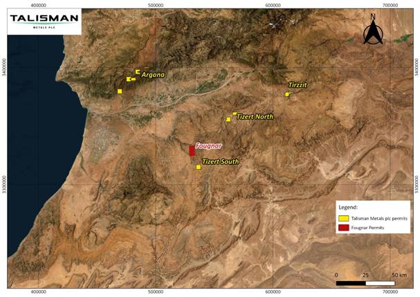
Figure 1: Project Location Map
End
For further information:
Talisman Metals PLC
Tim McCutcheon (Chief Executive Officer and Director)
Tel +353 (0) 1 525 6710
contactus@talismanmetalsplc.com
Beaumont Cornish Limited (Nominated Adviser)
James Biddle / Roland Cornish
Tel: +44 (0) 207 628 3396
CMC Markets UK Plc (Broker)
Thomas Smith / Thomas Curran
Tel: +44 (0) 20 3003 8255
BlytheRay (Financial PR)
Megan Ray / Said Izagaren
Tel: +44 (0) 20 7138 3204
talismanmetals@blytheray.com
JORC Code (2012) - Historical Exploration Results Disclaimer
The information in this announcement that relates to historical reported exploration results is based on, and fairly represents, information and supporting documentation prepared by previous operators and/or extracted from historical reports.
The historical exploration results referred to in this announcement were reported prior to the introduction of the JORC Code (2012) and have not been reported in accordance with the JORC Code (2012).
A Competent Person has not done sufficient work to disclose the historical exploration results in accordance with the JORC Code (2012). It is possible that following further evaluation and/or exploration work, the accuracy and reliability of the historical exploration results may not be confirmed.
The Company has not independently verified the historical exploration results, and no assurance can be given that future exploration work will result in the confirmation or upgrade of the historical results to JORC Code (2012) compliant Mineral Resources or Ore Reserves.
The Company considers the historical exploration results to be relevant as they provide an indication of the potential of the project. However, the information should not be relied upon as a representation of the current mineral resource or exploration potential.
Technical Glossary
|
Ag |
Silver |
|
Cu |
Copper |
|
CRM |
Certified reference materials |
|
"Transient Electromagnetics ("TEM") surveys" |
A geophysical technique used to obtain vertical resistivity soundings and is particularly effective for detecting conductive materials. It operates by inducing electric current flow within the subsurface and measuring the subsequent decay response of the magnetic field. |
|
"Induced Polarisation ("IP") surveys" |
A geophysical imaging technique used to identify the electrical chargeability of subsurface materials. The process involves transmitting an electric current into the ground and measuring the voltage decay curve after the current is switched off, which indicates the material's capacity to retain charges over time. |
|
"Reverse Circulation ("RC") drilling" |
A fast, cost-effective method for collecting rock samples. Compressed air is pumped down the annulus (the space between inner and outer drilling tubes), while pulverized rock cuttings are forced back up through the inner tube to the surface. This "reverse" flow is what gives the method its name and ensures dry, uncontaminated samples suitable for analysis. |
Nominated Adviser Statement
Beaumont Cornish Limited ("Beaumont Cornish"), is the Company's Nominated Adviser and is authorised and regulated in the United Kingdom by the Financial Conduct Authority. Beaumont Cornish's responsibilities as the Company's Nominated Adviser, including a responsibility to advise and guide the Company on its responsibilities under the AIM Rules for Companies and AIM Rules for Nominated Advisers, are owed solely to the London Stock Exchange. Beaumont Cornish is not acting for and will not be responsible to any other person for providing the protections afforded to customers of Beaumont Cornish nor for advising them in relation to the transaction and arrangements described in the announcement or any matter referred to in it.
RNS may use your IP address to confirm compliance with the terms and conditions, to analyse how you engage with the information contained in this communication, and to share such analysis on an anonymised basis with others as part of our commercial services. For further information about how RNS and the London Stock Exchange use the personal data you provide us, please see our Privacy Policy.

Latest directors dealings
- 5 hours ago Molten Ventures
- 5 hours ago National Grid
- 5 hours ago Origin Enterprises (CDI)
- 6 hours ago Computacenter
- 6 hours ago Norcros