Redmoor - 2026 Mineral Resource Estimate
Summary by AI BETAClose X
The information contained within this announcement is deemed by the Company to constitute inside information as stipulated under the Market Abuse Regulations (EU) No. 596/2014 ('MAR') which has been incorporated into UK law by the European Union (Withdrawal) Act 2018.
26 March 2026
Strategic Minerals plc
("Strategic Minerals" or the "Company")
Redmoor - 2026 Mineral Resource Estimate
Updated JORC (2012) Inferred Mineral Resource Estimate of 17.4 Mt @ 0.65% WO3.Eq; Representing a 49% Increase in Tonnage and Contained Metals Increases
Strategic Minerals plc (AIM: SML; USOTC: SMCDF), an international mineral exploration and production company, is pleased to announce an updated Mineral Resource Estimate ("MRE") for the Redmoor tungsten-tin-copper-silver Project ("Redmoor") in southeast Cornwall, UK held by its wholly owned subsidiary, Cornwall Resources Limited ("CRL").
2026 MRE Highlights
· 100% Inferred MRE reported in accordance with JORC (2012) of 17.4 Mt @ 0.65% Tungsten Trioxide Equivalent*1 ("WO3.Eq"):
· Represents a 49% increase in tonnage compared to the previous 2019 MRE.
· 2.4x increase in potential mine life from 12 to 29 years, at 2020 Scoping Study production rate.
· The 2026 MRE comprises 17.4 Mt at 0.65% WO3 Eq, including 0.49% WO₃, 0.17% Sn and 0.44% Cu: containing 85.8 kt WO3, 29.0 kt Sn and 76.3 kt Cu.
See Table 1 and 2 for full details of tonnes/grade and contained metals.
· Significant increase in contained metal within the 2026 MRE, including:
· Tungsten trioxide (WO3): 31% increase in contained WO3
· Tin (Sn): 55% increase in contained Sn
· Copper (Cu): 30% increase in contained Cu
· Silver (Ag): with an average grade of 5.8 g/t, and 3,231 koz contained silver. Silver included as a Cu concentrate credit at 270g/t.
· Mineral Resources are reported within underground Mineable Shape Optimiser (MSO) stope shapes and above a net smelter return ("NSR") cut-off of US$110/t, demonstrating reasonable prospects for eventual economic extraction ("RPEEE").
· An Exploration Target of 1.8 - 3.4 Mt JORC (2012) grading 0.4 - 0.6% WO3, 0.08 - 0.12% Sn and 0.2 - 0.3% Cu has also been identified outside of the current MRE
· Confirms Redmoor at 0.49% WO3 (0.65% WO3.Eq) is Europe's highest-grade, undeveloped, tungsten project compared to other CRIRSCO-compliant projects*2.
· See RNS 26 March 2026: "Redmoor - Updated Economic Sensitivity Analysis" for economic assessment of the Redmoor Project based on metal price scenarios and outputs of NPV and IRR calculations.
The MRE for the Redmoor deposit as of 16 March 2026 (MRE model completion date) is presented in Table 1 (tonnes and grade) and Table 2 (contained metal). The MRE has been reported and classified in accordance with the JORC Code (2012) and has been evaluated for RPEEE, assuming underground mining methods.
Mineral Resources for underground have been reported within MSO stope shapes and an NSR cut-off value of US$110/t.
Table 1: Redmoor MRE (tonnages and grades), as of 16 March 2026 (see Figure 3)
|
Resource category |
Domain |
Tonnage |
NSR |
WO3 Eq grade |
WO3 grade |
Sn grade |
Cu grade |
Ag grade |
|
Inferred |
Tungsten HGDs |
7.30 |
499 |
0.98 |
0.83 |
0.12 |
0.53 |
7.0 |
|
Tin HGDs |
1.95 |
208 |
0.44 |
0.14 |
0.50 |
0.50 |
7.6 |
|
|
Cu Domain SVS |
8.02 |
196 |
0.40 |
0.28 |
0.13 |
0.34 |
4.3 |
|
|
Low Grade SVS |
0.12 |
125 |
0.25 |
0.17 |
0.10 |
0.16 |
2.7 |
|
|
Total Inferred |
17.40 |
324 |
0.65 |
0.49 |
0.17 |
0.44 |
5.8 |
|
|
Total Mineral Resources |
17.40 |
324 |
0.65 |
0.49 |
0.17 |
0.44 |
5.8 |
|
|
The preceding statement of Mineral Resources conforms to the Australasian Code for Reporting of Exploration Results, Mineral Resources and Ore Reserves (JORC Code) 2012 Edition. All tonnages reported are dry metric tonnes. Minor discrepancies may occur due to rounding to appropriate significant figures. |
||||||||
Table 2: Redmoor MRE (contained metal), as of 16 March 2026
|
Resource category |
Domain |
WO3 content |
Sn content |
Cu content |
Ag content |
|
Inferred |
Tungsten HGDs |
60.5 |
8.7 |
38.9 |
1,632 |
|
Tin HGDs |
2.8 |
9.7 |
9.7 |
475 |
|
|
Cu Domain SVS |
22.3 |
10.6 |
27.5 |
1,114 |
|
|
Low Grade SVS |
0.2 |
0.1 |
0.2 |
10 |
|
|
Total Inferred |
85.8 |
29.0 |
76.3 |
3,231 |
|
|
Total Mineral Resources |
85.8 |
29.0 |
76.3 |
3,231 |
|
|
The preceding statements of Mineral Resources conforms to the Australasian Code for Reporting of Exploration Results, Mineral Resources and Ore Reserves (JORC Code) 2012 Edition. All tonnages reported are dry metric tonnes. Minor discrepancies may occur due to rounding to appropriate significant figures. |
|||||
Notes on 2026 MRE:
· The Competent Person for the MRE is Mr Laurie Hassall, FIMMM, QMR, FGS, of Snowden Optiro.
· The Effective Date of the MRE is 16 March 2026.
· The MRE is reported in accordance with the JORC Code (2012 Edition).
· Mineral Resources are constrained by RPEEE underground stope shapes and using an NSR cut-off value of US$110/t. Also constrained by a 200 m crown pillar below surface (tonnes reported below the -20 mRL), in order to ensure underground resources are not reported directly below surface dwellings.
· NSR has been calculated using the following formula:
((WO₃_%x550)+(Sn_%x222)+MAX(((Cu_%x73)+Ag_ppmx1.02)-(As_%x25))),0.
· NSR assumptions are as follows: APT (ammonium paratungstate) metal price of US$850/mtu, tin metal price of US$38,000/t, copper metal price of US$11,000/t, a silver metal price of US$75/oz and an arsenic penalty in copper concentrate of US$3/dmt per 0.1% As above 0.2% in copper concentrate. A WO3 processing recovery of 86%, a tin processing recovery of 67%, a copper processing recovery of 82% and a silver processing recovery to copper concentrate of 59%, all recoveries derived from 2026 testwork. A payability of 78% for WO3, 90% for tin, 90% for copper and 75% for silver. A royalty of 3% for all metals other than silver (4%). Concentrate treatment cost of US$100/dmt and a refining cost of US$236/t for copper. Mining costs of US$70.21/t, processing cost of US$21.36/t, a pumping and treatment cost of US$6.4/t, and a general and administration (G&A) cost of US$12.5/t.
· WO3 Eq has been calculated using the following formula (note*1 regarding Tungsten Equivalent calculation):
(WO3_%+(Sn_%*0.403)+(Cu_%*0.133)+(Ag_ppm*0.0046)).
· WO3 Eq has used identical assumptions as used for the NSR calculation.
· Tonnage estimates are based on dry in-situ densities derived from geological domain density measurements applied to the block model.
· Tonnes and grades are rounded and may result in minor discrepancies.
· All tonnage reported on a dry basis and are rounded to reflect the relative accuracy of the estimate. Totals may not sum due to rounding.
· 1 troy ounce = 31.1034768 g.
· WO3 Eq content derived from the WO3 Eq grade and tonnes.
· Mineral Resources are 100% Inferred. Mineral Resource classification is based on geological confidence, drill spacing, data quality and grade continuity.
· Mineral Resources are not Mineral Reserves and do not have demonstrated economic viability.
· Environmental, permitting, legal, and other factors could materially affect the MRE.
• Data cut-off for the MRE was 24 February 2026.
Comparison between 2026 MRE and previous 2019 MRE
The 2026 MRE represents a substantial update to the previous estimate completed by Geologica (UK) in February 2019, with a 49% increase in tonnages, and significant increases in all contained metals, see Table 3, with further notes on comparison, and Figure 1 model comparison, below:
Table 3: Redmoor 2026 MRE vs 2019 MRE comparison
|
MRE |
Tonnage |
WO3 grade |
WO3 content |
Sn grade |
Sn content |
Cu grade |
Cu content |
|
2019 Total Inferred |
11.70 |
0.56 |
65.5 |
0.16 |
18.7 |
0.50 |
58.5 |
|
2026 Total Inferred |
17.40 |
0.49 |
85.8 |
0.17 |
29.0 |
0.44 |
76.3 |
|
Percentage Difference |
49% |
-12% |
31% |
4% |
55% |
-12% |
30% |
· Updated geological and mineralisation models incorporating revised interpretations of the Redmoor deposit.
· Inclusion of historical South West Minerals ("SWM") drilling data from the 1980s, including logging and sampling information, to better inform geological modelling and the MRE.
· Inclusion of additional CRL sampling from 2017-2018, following targeted re-logging and sampling of intervals that were previously unsampled.
· Inclusion of nine CRL drillholes completed in 2025 (4,998 m), designed to verify historical SWM drilling, infill previously untested areas, and support evaluation of drill spacing required for higher-confidence resource classification.
· The 2025 drilling has confirmed continuity of mineralisation in areas that were previously sparsely drilled or untested.
· Expanded mineralisation modelling, including previously unmodelled HGDs and lodes, enabled by the incorporation of historic drilling and new geological interpretation.
· Updated domain modelling including separate tungsten and tin HGDs, a broad copper zone within the SVS, and a low-grade SVS envelope, see Figure 2.
· Updated metal price assumptions and metallurgical recoveries, incorporating results from recent 2025-2026 metallurgical testwork including full flowsheet testing.
· The Mineral Resource is now reported within underground MSO stope shapes and above an NSR cut-off, reflecting RPEEE, which was not applied in the 2019 estimate.
• The updated Mineral Resource excludes mineralisation between surface and −20 mRL (200 m crown pillar) to account for potential planning constraints related to blasting vibrations beneath surface dwellings, as highlighted in the 2020 Scoping Study.
Dennis Rowland, CRL Managing Director, said:
"Through the UK Shared Prosperity match grant funded project for each £1 of match grant funding spent a c.100:1 increase in market capitalisation in a 12-month period. From the outset we established clear aims to test short-spaced continuity of structure and grade; to confirm the validity of the 1980s datasets; to infill a high-priority section of the Exploration Target; and to incorporate new datasets to establish the potential presence of additional zones of mineralisation. We have been successful in these aims and the effects of each of these is reflecting in the robust improvements in the MRE.
"These results alongside the significant improvements in metallurgical recovery for tungsten, and confirmation of recoverability of silver, have directly contributed to improved project economics (see RNS 26 March 2026 - Updated Economic Sensitivity Analysis). I would like to thank the team at CRL for their hard work and performance, the Shared Prosperity team at Cornwall Council, the Strategic Minerals Board for their guidance and support, and our consultants for their efforts. I look forward to continuing to move Redmoor forward towards mining."
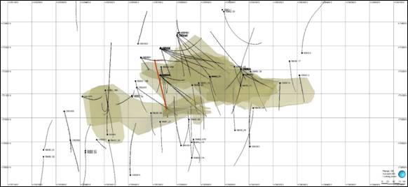
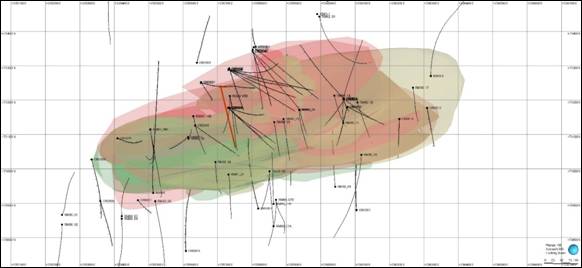
Figure 1: (top - old model) Plan view of the previously modelled high-grade domains (in gold) used in the 2019 Redmoor MRE, showing CRD036 (in red) and other drillhole traces (in black). (bottom - new model) Plan view of the deposit including the newly modelled high-grade domains (red-tungsten and green-tin), as well as the lower grade SVS envelope (in gold).
|
|
|
|
Mark Burnett, Strategic Minerals' Executive Director, said:
"The significant increases in tonnages, contained tungsten and other metals, and the inclusion of silver have provided a transformational uplift in Redmoor's MRE. Importantly, mineable tonnage has increased 2.4 times and presents the potential for a 29-year life of mine, at the 2020 Scoping Study production rates of 600 Kt/pa, as compared with a 12-year life of mine previously. The Company will now rapidly progress to prefeasibility study ("PFS") to test these new production scenarios and optimise the model.
"Redmoor is Europe's highest grade, undeveloped, tungsten resource compared to other CRIRSCO-compliant projects, and amongst the highest grade globally. The Company is committed to advancing Redmoor at pace, with today's results highlighting the contained metal potential of the Project. A fully funded infill drilling campaign to increase resource confidence for the conversion of inferred to indicated mineral resources is commencing and expected to scale up before the summer through the addition of more drill rigs, with the Company fully focussed on the delivery of the PFS work programme."
Charles Manners, Strategic Minerals' Executive Chairman, said:
"I cannot speak highly enough about the exemplary project design and delivery by the CRL team. It is hard to find any comparable project that has delivered so much, in such a short time, for the amount spent, and with such positive results. We are also deeply grateful to the many people who worked tirelessly to deliver this transformational piece of work. In particular we thank Snowden Optiro for their work, especially Laurie Hassall, the management and staff of Priority Drilling for their diligent work in the field, and Alfred H Knight for its metallurgical programme.
"The Company is also enormously grateful to the Cornwall Council and the Shared Prosperity Fund for their support with a grant in April 2025. This unlocked private sector investment and enabled the highly successful work over the last 12 months that has led to this transformational result that positions Redmoor and the UK to become a leading Western World source of tungsten."
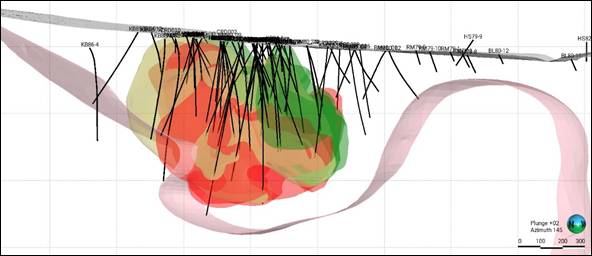
Figure 2: Oblique view looking south of updated geological model showing tungsten HGDs (red), tin HGDs (green) and SVS envelope (gold)
2026 MRE ADDITIONAL INFORMATION
Grade Tonnage Assessment
The grade-tonnage tabulation by NSR (US$/t) and grade-tonnage curve have been presented in Figure 3 and Table 4 respectively. The grade-tonnage has been reported inside of the RPEEE MSO stope shapes. The increase in metal prices moved more lower-grade tonnes above the NSR cutoff, with the effect of a marginal decrease in grade, but an increase in contained metal.
Figure 3: Grade tonnage curve for the Redmoor 2026 Mineral Resource
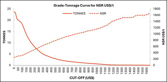
Table 4: Grade tonnage tabulation for the Redmoor 2026 Mineral Resource
|
Cut-off NSR (US$/t) |
NSR (US$/t) |
WO3_Eq (%) |
WO3 (%) |
Sn (%) |
Cu (%) |
Ag (g/t) |
Tonnes |
|
0 |
253 |
0.51 |
0.38 |
0.14 |
0.38 |
4.99 |
23.6 |
|
50 |
293 |
0.59 |
0.44 |
0.16 |
0.42 |
5.57 |
20.0 |
|
100 |
314 |
0.63 |
0.48 |
0.17 |
0.43 |
5.72 |
18.2 |
|
150 |
376 |
0.74 |
0.59 |
0.16 |
0.46 |
6.09 |
13.7 |
|
200 |
441 |
0.87 |
0.71 |
0.16 |
0.50 |
6.51 |
10.4 |
|
250 |
500 |
0.98 |
0.82 |
0.14 |
0.51 |
6.70 |
8.2 |
|
300 |
562 |
1.09 |
0.94 |
0.13 |
0.51 |
6.72 |
6.4 |
|
350 |
631 |
1.22 |
1.07 |
0.12 |
0.52 |
6.82 |
5.0 |
|
400 |
681 |
1.31 |
1.17 |
0.11 |
0.53 |
6.90 |
4.2 |
|
450 |
735 |
1.41 |
1.27 |
0.10 |
0.53 |
6.88 |
3.4 |
|
500 |
784 |
1.51 |
1.37 |
0.08 |
0.53 |
6.85 |
2.9 |
|
550 |
839 |
1.61 |
1.48 |
0.07 |
0.53 |
6.75 |
2.4 |
|
600 |
884 |
1.69 |
1.57 |
0.06 |
0.53 |
6.75 |
2.0 |
|
650 |
925 |
1.77 |
1.65 |
0.05 |
0.53 |
6.64 |
1.8 |
|
700 |
961 |
1.84 |
1.71 |
0.05 |
0.54 |
6.81 |
1.5 |
|
750 |
997 |
1.90 |
1.78 |
0.05 |
0.53 |
6.78 |
1.3 |
|
800 |
1029 |
1.96 |
1.84 |
0.04 |
0.54 |
6.94 |
1.2 |
|
850 |
1058 |
2.02 |
1.89 |
0.04 |
0.55 |
7.16 |
1.0 |
Exploration Potential
The Exploration Target at the Redmoor deposit refers to mineralised material that has been interpreted from geological modelling and limited drillhole information but lies outside the current Mineral Resource classification envelope. These areas are considered prospective for mineralisation; however, the available drilling density, geological confidence, and grade continuity are insufficient to support classification as an Inferred Mineral Resource in accordance with the JORC Code (2012).
The Exploration Target tonnage and grade estimates have been derived using the existing geological model, but they are conceptual in nature and should not be interpreted as Mineral Resources. Further drilling, geological confirmation, and additional sampling are required before any portion of this material could be upgraded to an Inferred Mineral Resource. There is no certainty that further exploration will result in the delineation of a Mineral Resource. In accordance with the JORC Code (2012), an Exploration Target must be reported as a range of tonnage and grade. Between 1.8 Mt and 3.4 Mt has been classified as an Exploration Target, based on the criteria outlined above. This is shown in Table 5.
Table 5: Redmoor Exploration Target
|
Tonnage |
WO3 Eq grade |
WO3 grade |
Sn grade |
Cu grade |
Ag grade |
|
1.8-3.4 |
0.5-0.7 |
0.4-0.6 |
0.08-0.12 |
0.2-0.3 |
2.6-4.0 |
Notes: The quantities and grades presented for Exploration Target are conceptual and are reported outside the MRE. These figures are not Mineral Resources and do not have RPEEE at this stage. There is no certainty that further exploration will result in the delineation of a Mineral Resource.
Classification
The Mineral Resource has been classified following the guidelines of the Australasian Code for Reporting of Exploration Results, Mineral Resources and Ore Reserves, 2012 (the JORC Code). The Mineral Resource has been classified as Inferred on the basis of confidence in geological and grade continuity, by taking into account the quality of the sampling and assay data, and confidence in estimation of WO3, tin and copper. The classification criteria were assigned on an individual domain basis and were based on the robustness of the grade estimate as determined from the drillhole spacing, geological confidence and grade continuity and reflects the confidence and uncertainty in the model.
Inferred: All domains below the designated blast safety buffer, supported by drilling intersections at spacings of approximately 100-200 m along strike and 60-120 m down dip. Classification is further supported by appropriate quality assurance and quality control (QAQC) procedures and the overall quality and integrity of the assay dataset.
Reasonable Prospect for Eventual Economic Extraction ("RPEEE") Assessment
The Redmoor Mineral Resource has been assessed for RPEEE in accordance with the JORC Code.
Underground RPEEE
The underground 2026 MRE was reported within Datamine MSO optimised stope shapes to satisfy the requirement for RPEEE. The assumed mining method is sublevel open stoping and this was assumed as a mining method for the Redmoor 2020 Scoping Study.
The RPEEE test is important to demonstrate the robustness of an MRE. The input parameters for the underground optimisation are summarised in Table 6.
Table 6: RPEEE underground (MSO) optimisation parameters and inputs
|
Project item |
Units |
Value |
|
Factors |
||
|
Panel size |
m |
10 mL x 20 mH |
|
Dilution |
m |
1 |
|
Minimum width |
m |
3 |
|
Mining recovery |
% |
95 |
|
Pillar dimension |
m |
6 |
|
Min dip |
° |
40 |
|
Process recovery |
% |
Variable by metal refer to NSR inputs |
|
Financial |
||
|
Price |
US$/t or oz |
Variable by metal refer to NSR inputs |
|
Mining cost - Underground |
US$/t |
70.21 |
|
Processing cost |
US$/t ore |
21.40 |
|
Water treatment |
US$/t ore |
6.40 |
|
G&A |
US$/t ore |
12.50 |
|
Royalty |
% price |
3% (4% for Ag) |
Underground Mineral Resources are reported within optimised MSO stope shapes generated in Datamine using an NSR cut-off value of US$110/t. The Mineral Resource is further constrained by a 200 m crown pillar below surface, such that resources are reported below −20 mRL. This crown pillar has been applied to ensure that underground Mineral Resources are not reported beneath surface dwellings where, due to local planning constraints, there is no reasonable expectation that underground blasting could occur.
Previous MREs for Redmoor reported mineralisation to surface. The 2020 Redmoor Scoping Study adopted a 250 m crown pillar, based on a limited desktop review of comparable projects in the UK and Ireland. The current MRE has adopted a reasonable crown pillar based on the current uncertainty regarding the depth at which underground mining may be permitted beneath surface dwellings.
Mineral Resources are reported undiluted within the MSO stope shapes.
For context, a fully diluted mineral inventory is presented Table 7. This inventory is not part of the reported Mineral Resource and is provided for informational purposes only.
Table 7: Redmoor deposit overall mineral inventory within MSO stope shapes
|
Domain |
Tonnage |
NSR |
WO3 Eq grade |
WO3 grade |
Sn grade |
Cu grade |
Ag grade |
|
Tungsten HGDs |
7.33 |
497 |
0.98 |
0.83 |
0.12 |
0.53 |
6.9 |
|
Tin HGDs |
2.04 |
204 |
0.43 |
0.14 |
0.49 |
0.49 |
7.4 |
|
Cu Domain SVS |
10.19 |
173 |
0.36 |
0.24 |
0.13 |
0.34 |
4.4 |
|
Low Grade SVS |
4.06 |
36 |
0.08 |
0.04 |
0.04 |
0.13 |
1.8 |
|
Total |
23.62 |
253 |
0.51 |
0.38 |
0.14 |
0.38 |
5.0 |
Figure 4 shows a long section of the MSO stope shapes coloured by NSR. The 2026 Updated Economic Sensitivity Analysis is based upon the mineral inventory.
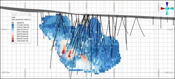
Figure 4: Long section (looking south) showing MSO stope shapes coloured by NSR used to report the Redmoor 2026 Mineral Resource
Forward Looking Statement:
This report contains "forward-looking information" that is based on the Company's expectations, estimates and forecasts as of the date on which the statements were made. This forward-looking information includes, among other things, statements with respect to the Company's business strategy, plans, objectives, performance, outlook, growth, cash flow, earnings per share and shareholder value, projections, targets and expectations, mineral reserves and resources, results of exploration and related expenses, property acquisitions, mine development, mine operations, drilling activity, sampling and other data, grade and recovery levels, future production, capital costs, expenditures for environmental matters, life of mine, completion dates, commodity prices and demand, and currency exchange rates. Generally, this forward-looking information can be identified by the use of forward-looking terminology such as "outlook", "anticipate", "project", "target", "likely", "believe", "estimate", "expect", "intend", "may", "would", "could", "should", "scheduled", "will", "plan", "forecast" and similar expressions. The forward-looking information is not factual but rather represents only expectations, estimates and/or forecasts about the future and therefore need to be read bearing in mind the risks and uncertainties concerning future events generally.
Competent Person Statement:
Snowden Optiro has been engaged by Cornwall Resources Limited to provide independent technical advice. The information in this report that relates to the Estimation and Reporting of Mineral Resources has been compiled by Mr Laurie Hassall, MSci, QMR, FIMMM, FGS, who is a full-time employee of Snowden Optiro and is independent of Cornwall Resources Ltd (CRL).
Mr Hassall is a Fellow of the Institute of Materials, Minerals and Mining (FIMMM) and Qualified for Minerals Reporting (QMR). Mr Hassall has sufficient experience that is relevant to the style of mineralisation and type of deposit under consideration and to the activity being undertaken to qualify as a Competent Person as defined in the 2012 Edition of the Australasian Code for Reporting of Exploration Results, Mineral Resources and Ore Reserves (JORC Code) and a Qualified Person under the AIM Rules .
Mr Hassall consents to the inclusion in this announcement of the matters based on his information, in the form and context in which it appears. He confirms that, to the best of his knowledge, there is no new information or data that materially affects the information contained in previous market announcements, and that the form and context in which the information is presented has not been materially modified.
|
For further information, please contact: |
|
|
|
|
|
|
|
Strategic Minerals plc |
+44 (0) 207 389 7067 |
|
|
Mark Burnett |
|
|
|
Executive Director |
|
|
|
Website: |
||
|
Email: |
||
|
|
|
|
|
Follow Strategic Minerals on: |
|
|
|
X: |
||
|
LinkedIn: |
||
|
|
|
|
|
SP Angel Corporate Finance LLP |
+44 (0) 20 3470 0470 |
|
|
Nominated Adviser and Broker |
|
|
|
Matthew Johnson/Charlie Bouverat/Grant Barker
Zeus Capital Limited Joint Broker Harry Ansell/Katy Mitchell |
+44 (0) 203 829 5000 |
|
|
|
|
|
|
Vigo Consulting |
+44 (0) 207 390 0234 |
|
|
Investor Relations |
|
|
|
Ben Simons/Peter Jacob/Anna Sutton |
|
|
|
Email: |
|
|
Notes to Editors
About Strategic Minerals plc and Cornwall Resources Limited
Strategic Minerals plc (AIM: SML; USOTC: SMCDY) is an AIM-quoted, producing minerals company, actively developing strategic projects in the UK, United States and Australia.
In 2019, the Company completed the 100% acquisition of Cornwall Resources Limited and the Redmoor Tungsten-Tin-Copper Project.
The Redmoor Project is situated within the historically significant Tamar Valley Mining District in Cornwall, United Kingdom, with a JORC (2012) Compliant Inferred Mineral Resource Estimate published 26 March 2026:
|
Resource category |
Domain |
Tonnage |
NSR |
WO3 Eq grade |
WO3 grade |
Sn grade |
Cu grade |
Ag grade |
|
Inferred |
Tungsten HGDs |
7.30 |
499 |
0.98 |
0.83 |
0.12 |
0.53 |
7.0 |
|
Tin HGDs |
1.95 |
208 |
0.44 |
0.14 |
0.50 |
0.50 |
7.6 |
|
|
Cu Domain SVS |
8.02 |
196 |
0.40 |
0.28 |
0.13 |
0.34 |
4.3 |
|
|
Low Grade SVS |
0.12 |
125 |
0.25 |
0.17 |
0.10 |
0.16 |
2.7 |
|
|
Total Inferred |
17.40 |
324 |
0.65 |
0.49 |
0.17 |
0.44 |
5.8 |
|
|
Total Mineral Resources |
17.40 |
324 |
0.65 |
0.49 |
0.17 |
0.44 |
5.8 |
|
|
The preceding statement of Mineral Resources conforms to the Australasian Code for Reporting of Exploration Results, Mineral Resources and Ore Reserves (JORC Code) 2012 Edition. All tonnages reported are dry metric tonnes. Minor discrepancies may occur due to rounding to appropriate significant figures. |
||||||||
More information on Cornwall Resources can be found at: https://www.cornwallresources.com
In September 2011, Strategic Minerals acquired the distribution rights to the Cobre magnetite project in New Mexico, USA, through its wholly owned subsidiary Southern Minerals Group. Cobre has been in production since 2012 and continues to provide a sustainable revenue stream for the Company.
In March 2018, the Company completed the acquisition of the Leigh Creek Copper Mine situated in the copper rich belt of South Australia. The Company has entered into an exclusive Call Option with South Pacific Mineral Investments Pty Ltd trading as Cuprum Metals to acquire 100% of the project.
About the CIOS Good Growth Fund and UK Shared Prosperity Fund
This project is part-funded by the UK Government through the UK Shared Prosperity Fund. Cornwall Council is responsible for managing projects funded by the UK Shared Prosperity Fund through the Cornwall and the Isles of Scilly Good Growth Programme.
Cornwall and Isles of Scilly has been allocated £184 million for local investment through the Shared Prosperity Fund. This new approach to investment is designed to empower local leaders and communities, so they can make a real difference on the ground where it's needed the most.
The UK Shared Prosperity Fund proactively supports delivery of the UK-government's five national missions: pushing power out to communities everywhere, with a specific focus to help kickstart economic growth and promoting opportunities in all parts of the UK.
For more information, visit
https://www.gov.uk/government/publications/uk-shared-prosperity-fund-prospectus
For more information, visit https://ciosgoodgrowth.com

JORC Code, 2012 Edition - Table 1 report
Section 1 Sampling Techniques and Data
(Criteria in this section apply to all succeeding sections.)
|
Criteria |
JORC Code explanation |
Commentary |
|
Sampling techniques |
· Nature and quality of sampling (eg cut channels, random chips, or specific specialised industry standard measurement tools appropriate to the minerals under investigation, such as down hole gamma sondes, or handheld XRF instruments, etc). These examples should not be taken as limiting the broad meaning of sampling. · Include reference to measures taken to ensure sample representivity and the appropriate calibration of any measurement tools or systems used. · Aspects of the determination of mineralisation that are Material to the Public Report. · In cases where 'industry standard' work has been done this would be relatively simple (eg 'reverse circulation drilling was used to obtain 1 m samples from which 3 kg was pulverised to produce a 30 g charge for fire assay'). In other cases more explanation may be required, such as where there is coarse gold that has inherent sampling problems. Unusual commodities or mineralisation types (eg submarine nodules) may warrant disclosure of detailed information. |
CRL 2025 drilling · Diamond drill core was oriented and aligned prior to sampling and cut longitudinally using a diamond core saw. Half-core samples were collected, with the remaining half retained for reference. Sampling was undertaken based on geological boundaries and mineralisation style, with typical sample lengths of approximately 1 m, extending up to 2 m in zones of lower mineralisation. · Unmineralised intervals were generally not sampled; however, selected drillholes (e.g. CRD033) were sampled in full to support geochemical characterisation of the broader mineralised system. · Drillhole orientation was designed to intersect the sheeted vein system (SVS) as close as possible to perpendicular in order to obtain representative sample widths. CRL 2017-2018 drilling · Diamond drill core was oriented, aligned and halved using a core saw, with sampling conducted based on geological boundaries. Sample intervals were typically 1 m, extending up to 2.5 m in less mineralised zones. · Unmineralised intervals were generally not sampled. Sampling protocols are considered appropriate for the style of mineralisation. · Drillholes were oriented where possible to intersect mineralisation at high angles. Due to the presence of multiple mineralised orientations and access constraints, not all drillholes achieved optimal orientation. SWM 1980-1983 drilling · Historical diamond drilling completed by South West Minerals (SWM) between 1980 and 1983 forms part of the Redmoor database and split core samples have been incorporated into the current 2026 Mineral Resource estimate. · Historical sampling was undertaken on diamond drill core, with samples collected for both assay and density determination. · Drillholes were generally oriented to intersect mineralisation at high angles; however, some lodes (e.g. Johnson's Lode), which dip in an opposing direction to the main SVS, were intersected at lower angles. · Historical assay data were subject to verification through check sampling programmes undertaken by Robertson Research International, Alfred H. Knight, and subsequent resampling by SRK/NAE. Additional validation has been provided through Snowden Optiro's 2025 data review and twin-hole comparisons, supporting the reliability of the dataset for Mineral Resource estimation. |
|
Drilling techniques |
· Drill type (eg core, reverse circulation, open-hole hammer, rotary air blast, auger, Bangka, sonic, etc) and details (eg core diameter, triple or standard tube, depth of diamond tails, face-sampling bit or other type, whether core is oriented and if so, by what method, etc). |
CRL drilling · All CRL drilling (2017, 2018 and 2025) was undertaken using diamond core drilling. Core diameters ranged from HQ3/HQ to NQ/BTW (approximately 63.5 mm to 42 mm). · Core orientation was undertaken using Reflex ACT tools (ACT II, ACT III and ACTx depending on campaign), with orientation achieved for the majority of the core, particularly within mineralised zones. SWM drilling (1980-1983) · Historic drilling by SWM was completed using HQ, NQ and BQ diamond core. · Drillholes were primarily oriented to intersect the northerly dipping SVS; however, some holes targeted southerly dipping lodes, resulting in variable intersection angles. |
|
Drill sample recovery |
· Method of recording and assessing core and chip sample recoveries and results assessed. · Measures taken to maximise sample recovery and ensure representative nature of the samples. · Whether a relationship exists between sample recovery and grade and whether sample bias may have occurred due to preferential loss/gain of fine/coarse material. |
CRL drilling · Core recovery was recorded on a run-by-run basis, typically within 24 hours of drilling, by measuring recovered core lengths against drilled run lengths and reconciling with core blocks. Core recovery was generally high, typically exceeding 90-95% across all campaigns, including within mineralised zones. · Broken ground, voids and zones of poor recovery were clearly logged. Triple-tube drilling was used where possible (2017 campaign) to maximise recovery in fractured zones. · No material relationship between core recovery and grade has been identified, and no evidence of sampling bias due to preferential loss or gain of material is considered present. SWM drilling · All historic drillholes were completed using HQ, NQ or BQ diamond core. · Core recovery was recorded in historical logs and is generally reported as high (typically 80-100%), with lower recoveries associated with poor ground conditions. · Where poor recovery occurred, holes were commonly re-drilled. There is no evidence of a systematic relationship between recovery and grade. |
|
Logging |
· Whether core and chip samples have been geologically and geotechnically logged to a level of detail to support appropriate Mineral Resource estimation, mining studies and metallurgical studies. · Whether logging is qualitative or quantitative in nature. Core (or costean, channel, etc) photography. · The total length and percentage of the relevant intersections logged. |
CRL drilling · All drill core was geologically, structurally and geotechnically logged to a level of detail suitable for Mineral Resource estimation. Logging included lithology, alteration, mineralisation, structure (including alpha and beta angles), and geotechnical characteristics. · Logging was undertaken digitally, supported by structural measurements using a Kenometer. Improvements to logging templates in 2025 enabled separation of lithological, structural, alteration and mineralisation datasets. · Core was photographed in full and linked to downhole geology within Leapfrog software. · Logging is both qualitative and quantitative in nature, and 100% of drilled intervals were logged. · Selected samples were submitted for petrographic analysis to support mineralogical interpretation. SWM drilling · Historical core was logged in detail, with qualitative mineralogical and geological descriptions recorded. Logs remain available for review and include all relevant mineralised intersections. |
|
Sub-sampling techniques and sample preparation |
· If core, whether cut or sawn and whether quarter, half or all core taken. · If non-core, whether riffled, tube sampled, rotary split, etc and whether sampled wet or dry. · For all sample types, the nature, quality and appropriateness of the sample preparation technique. · Quality control procedures adopted for all sub-sampling stages to maximise representivity of samples. · Measures taken to ensure that the sampling is representative of the in situ material collected, including for instance results for field duplicate/second-half sampling. · Whether sample sizes are appropriate to the grain size of the material being sampled. |
CRL 2025 drilling · Core was cut longitudinally using a diamond saw, with half-core samples submitted for analysis and the remaining half retained in the core trays as a reference record. Sampling was consistently undertaken from the same side of the orientation line to maintain representivity. · Half-core samples were submitted to ALS Loughrea for preparation and analysis. Sample weights were typically in the range of 2-7 kg. Samples were dried and crushed to better than 95% passing 2 mm, after which a 1,000 g split was taken and pulverised to better than 85% passing 75 µm. · QAQC procedures included the insertion of certified reference materials (for all analytes estimated in the 2026 MRE), blanks, coarse duplicates, pulp duplicates and umpire checks at independent laboratory. Internal laboratory QC data, including particle size checks, were reviewed to confirm preparation quality. · Sample preparation techniques and sample sizes are considered appropriate for the style, grain size and variability of the Redmoor mineralisation. CRL 2017-2018 drilling · Core was cut longitudinally using a diamond saw, with half-core samples submitted for analysis and the remaining half retained in the core trays as a reference record. Sampling was consistently undertaken from the same side of the orientation line. · Half-core samples were submitted to ALS Loughrea for preparation and analysis. Sample weights were typically in the range of 3-7 kg. · For holes CRD001 to CRD013, samples were dried and crushed to better than 70% passing 2 mm. A split of up to 250 g was then taken and pulverised to better than 85% passing 75 µm. · For holes CRD014 onwards, samples were dried and crushed to better than 95% passing 2 mm. A 1,000 g split was then taken and pulverised to better than 85% passing 75 µm. · QAQC procedures included insertion of blanks, standards and coarse duplicates. Internal laboratory QC data, including particle size checks, were reviewed, and duplicate sample results were assessed to confirm that sample preparation was not introducing material bias or unacceptable imprecision. · Sample preparation techniques and sample sizes are considered appropriate for the style, grain size and variability of the Redmoor mineralisation. SWM drilling · Historic SWM core was generally sampled at approximately 2 m intervals using both split-core and geochemical chip sampling methods. Chip samples, interpreted to comprise material washed from the core barrel, are considered non-representative and were excluded from Mineral Resource estimation. Only split-core samples were retained for verification and modelling purposes. · Sample-type codes in the database distinguish split-core samples, chip samples, and mixed sampling approaches. Contemporary QAQC procedures such as certified reference materials, blanks and duplicates were not routinely implemented during the 1980-1983 drilling campaigns. · Robertson Research International undertook retrospective checks with Alfred H. Knight (c.10% of samples) and re-assayed Redmoor submissions following identification and correction of an analytical issue, providing reasonable confidence in the WO₃ data. SRK/NAE later performed limited core resampling. · 2025 CRL drilling twinned three historic SWM holes, and Snowden Optiro undertook a detailed comparative review of lithology, structure and assay results, and is satisfied that the historical data are reliable for use in Mineral Resource estimation. |
|
Quality of assay data and laboratory tests |
· The nature, quality and appropriateness of the assaying and laboratory procedures used and whether the technique is considered partial or total. · For geophysical tools, spectrometers, handheld XRF instruments, etc, the parameters used in determining the analysis including instrument make and model, reading times, calibrations factors applied and their derivation, etc. · Nature of quality control procedures adopted (eg standards, blanks, duplicates, external laboratory checks) and whether acceptable levels of accuracy (ie lack of bias) and precision have been established. |
CRL 2025 drilling · Analysis by method ME-MS61 was carried out using a HF-HNO3-HClO4 acid digestion, HCl leach, and analysed with a combination of ICP-MS and ICP-AES, including Sn, Cu, and W. The upper and lower detection limits have previously been tested and predetermined by CRL and confirmed acceptable for the target elements of Sn, Cu, and W. A limited number of samples were also analysed for Cu, Pb and Zn by method OG62. · Where grades by method ME-MS61 exceed 0.30% W, as previously determined by internal review, an additional assay for high grade W by method ME-XRF15b was subsequently carried out. These results replace relevant W values for ME-MS61. Where grades by method ME-MS61 exceed 500 ppm Sn, an additional assay for high grade Sn was carried out using ME-XRF15b. · The laboratory shared their internal QC data on blanks, pulp duplicates and CRMs. CRL also inserted 7.5% CRMs to test WO₃, Sn and Cu analyses and 5% blanks along with 5% coarse and pulp duplicates, as a further control. · CRM standards were reproducible and within analytical ranges as certified; CRL's blanks show no significant contamination issues and the assays of the laboratory standards, which cover a range of metal values for each of Sn, Cu, WO₃, show no evidence of material bias. · 2.5 % of samples are selected for umpire assays at an independent laboratory and project-specific CRMs for WO₃ and Sn to maintain long-term analytical confidence. CRL 2017-2018 drilling · Analysis by method ME-ICP81x was carried out using a sodium peroxide fusion for decomposition and then analysed by ICP-AES for 34 elements, including Sn, Cu, and W. The upper and lower detection limits are considered acceptable for the target elements of Sn, Cu, and W. A limited number of samples were also analysed for silver by method Ag-ICP61. · Assay method selection (2017-2018): Where WO₃ by ME-ICP81x exceeded 0.50% WO₃, samples were re-analysed by XRF (ME-XRF15b) and the XRF results replaced the corresponding ICP values for reporting and resource evaluation. · Pulp re-assay and updated trigger (2024/2025): Following a review, the XRF trigger was lowered to 0.30% WO₃. CRL re-assayed 73 pulps by XRF at ALS; results showed an ~9% average increase in WO₃ relative to the original ICP assays (with the majority returning higher grades). This work confirms XRF as the preferred method for samples ≥0.30% WO₃ and supports its use for future estimation and reporting. · The laboratory shared their internal QC data on blanks, pulp duplicates and standards. CRL also inserted 5% each of blanks, standards and coarse duplicates, as a further control. · While there was some spread in the repeatability of the 2017 coarse rejects the results are acceptable and to industry guidelines; CRL's blanks show no significant contamination issues and the assays of the laboratory standards, which cover a range of metal values for each of Sn, Cu, W, show no bias subject to the protocol above being used. SWM drilling · Historic SWM drill core was predominantly sampled at ~2 m intervals using two methods: split half-core and geochemical chip sampling. Chip samples are interpreted to comprise material washed from the core barrel and are concentrated in low-grade or unmineralised zones; due to representativity limitations they are not recommended for use in grade estimation. Snowden Optiro have only used the split core samples for modelling and estimation. · Historical SWM assay data were generated by RRI using XRF and colorimetric methods; subsequent check work by Alfred H. Knight provide a basis for confidence in the original WO₃ results. · No additional information is available on the quality control programmes used for the historic drilling. · SRK/NAE re-sampled selected SWM core in 2012-2013 for verification. Snowden Optiro reviewed these results and concluded that the quarter-core versus quarter-core methodology was sub-optimal for the coarse, nuggety wolframite mineralisation at Redmoor. Future verification was recommended to employ half-core versus half-core resampling to maintain equivalent sample support, or through twin hole verification. |
|
Verification of sampling and assaying |
· The verification of significant intersections by either independent or alternative company personnel. · The use of twinned holes. · Documentation of primary data, data entry procedures, data verification, data storage (physical and electronic) protocols. · Discuss any adjustment to assay data. |
CRL 2025 drilling · All assay and QAQC data were internally reviewed by CRL geologists and the Exploration Manager, and independently reviewed by Snowden Optiro. · CRL had previously undertaken analytical checks on historical pulp samples, confirming the need to reduce the high-grade WO₃ re-assay trigger from 0.5% to 0.3%. This updated threshold was applied to the assay database used in the 2026 MRE. · Sn trigger levels were also tested and the 500 ppm threshold was retained. · 2025 CRL drilling twinned three historic SWM holes, and Snowden Optiro undertook a detailed comparative review of lithology, structure and assay tenor, and is satisfied that the historical split core data are sufficiently reliable for use in Mineral Resource estimation. CRL 2018 drilling · Geologica UK previously validated the 2018 drilling database against laboratory certificates. · In 2025, Snowden Optiro completed an additional independent review of the 2017-2018 assay data against original laboratory files. · CRL also undertook targeted pulp re-assays in 2024-2025 to confirm WO₃ grades using XRF. Snowden Optiro considers the resulting dataset fit for Mineral Resource estimation. CRL 2017 drilling · SRK previously reviewed the database and laboratory certificates and confirmed significant intersections. · In 2025, Snowden Optiro re-reviewed the 2017 data as part of the full MRE data assessment and confirmed the earlier conclusions regarding data integrity. · Snowden Optiro reviewed copies of CRL's assay database and laboratory certificates and compared significant intercepts. · SRK conducted a site visit and audit in 2017. Snowden Optiro completed multiple site visits in 2025 / 2026 and reviewed data entry, chain-of-custody and verification procedures. CRL maintains routine off-site backups, and Snowden Optiro recommended migration to a secure relational database and standardisation of historical and modern datasets. · Within significant intercepts, values at detection limits were replaced with half the detection limit. Where duplicate assays existed, the primary assay result was used unless otherwise justified. SWM 1980-1983 drilling · Historical SWM drilling pre-dates routine modern QAQC insertion; however, records indicate that RRI undertook internal check analyses and submitted approximately 10% of samples for Alfred H. Knight check assay. All Redmoor samples since April 1980 were re-assayed due to an issue with a faulty x-ray tube. Snowden Optiro considers this an appropriate historical verification step providing reasonable confidence in the WO₃ data. · SRK re-sampled selected SWM core in 2012-2013 for verification. Snowden Optiro reviewed this work and concluded that quarter-core versus quarter-core resampling was not ideal for coarse, nuggety wolframite mineralisation. · Snowden Optiro therefore recommended twin-hole drilling as a more appropriate verification approach. This was implemented by CRL in 2025. · Snowden Optiro and CRL jointly planned a programme of twin-hole drilling to verify SWM data through direct comparison of lithology, structure and grade tenor. All three twin holes presented the same principal mineralised zones and did not indicate any systematic grade bias. · Snowden Optiro also completed side-by-side sectional review and statistical checks, including Q-Q plots, depth-aligned paired analyses and grade-threshold comparisons, as part of its independent verification. · Collar locations for selected SWM holes were verified in the field using handheld GPS. Downhole survey data and the applied −8° magnetic-to-grid correction were also reviewed and confirmed as appropriate. · Snowden Optiro independently checked relevant original logs against the currently digitised database and considers that no material transcription errors are evident in the geological capture. |
|
Location of data points |
· Accuracy and quality of surveys used to locate drill holes (collar and down-hole surveys), trenches, mine workings and other locations used in Mineral Resource estimation. · Specification of the grid system used. · Quality and adequacy of topographic control. |
CRL 2025 drilling · Planned collar locations were recorded as six-figure grid references with RL in metres, in the British National Grid (OSGB) coordinate system. · Final collar coordinates were recorded using a Reach RS2 GPS receiver. Variation from planned position was generally within 10 m. · Collar RL's were draped on the 5 m resolution Lidar topographic surface. · Downhole surveys were undertaken using Reflex EZ-Trac at a minimum of every 30 m downhole. Multi-shot surveys were also collected when drill diameter was reduced from HQ to NQ and at end of hole, with readings taken every 3 m uphole. Aluminium extension rods were used to minimise magnetic error. · Data were synchronised to IMDEX HUB-IQ, with survey QAQC checks undertaken by CRL geologists. · Initial collar set-up used an optical sighting compass for azimuth and inclinometer for inclination, with azimuth checked prior to and after rig set-up. CRL 2018 drilling · Planned collars were recorded in British National Grid (OSGB) coordinates with RL in metres. · Collar surveys were completed using real-time corrected DGPS by 4D Civil Engineering Surveying Ltd, with final hole position generally within 5 m of the planned location. · Downhole surveys were conducted using Reflex EZ-Trac at minimum 50 m intervals. Aluminium rods were used to reduce magnetic interference. · Initial collar orientation used an optical sighting compass and inclinometer. CRL 2017 drilling · Collar coordinates were recorded in British National Grid (OSGB) with RL in metres and surveyed using real-time corrected DGPS by a professional survey company. · Downhole surveys were collected using Reflex EZ-Trac at a minimum of every 50 m downhole, using aluminium rods to minimise magnetic error. · Initial collar orientation used an optical sighting compass and inclinometer. SWM 1980-1983 drilling · Historic collar locations are recorded on drill logs as six-figure grid references in British National Grid (OSGB). · Where RL data were absent, SRK projected collars onto 2005 LiDAR topographic survey data. · Downhole surveys were typically collected using acid tube tests or single-shot survey cameras at approximately 50 m intervals. · Historic plans and drillhole traces were digitised, and Snowden Optiro reviewed collars against georeferenced plans and is satisfied that coordinate positions are adequate for Mineral Resource estimation. |
|
Data spacing and distribution |
· Data spacing for reporting of Exploration Results. · Whether the data spacing and distribution is sufficient to establish the degree of geological and grade continuity appropriate for the Mineral Resource and Ore Reserve estimation procedure(s) and classifications applied. · Whether sample compositing has been applied. |
CRL 2025 drilling · The 2025 programme aimed to extend previously identified mineralisation, verify the validity of the SWM drilling dataset through twin-hole drilling, and test mineralisation within the 2019 Exploration Target. · Twinned holes were typically spaced approximately 10-25 m from the corresponding historic holes and were drilled at similar azimuth and dip where practicable, in order to intersect the SVS at the same intersection point. · Samples were composited to 2 m for continuity analysis and grade estimation. CRL 2018 drilling · The 2018 programme was designed primarily to extend previously identified mineralisation. · Hole spacing is typically of the order of 70-150 m, locally closer. · This spacing is considered sufficient to support geological and grade continuity appropriate for an Inferred Mineral Resource classification. · Samples were composited to 2 m for continuity analysis and estimation. CRL 2017 drilling · The 2017 programme aimed to extend and improve continuity of previously identified mineralisation, as well as confirm the presence of the SVS, which was first discovered by SWM. · Within the SVS, drill spacing is typically around 100-150 m and locally less, depending on target geometry and access. · Compositing was applied on a length-weighted basis in support of intercept calculations and later resource estimation workflows. SWM 1980-1983 drilling · Historic drillholes and sample intersections are typically around 100-150 m apart within the main lodes and lode systems, including the SVS, Johnson's Lode and Great South Lode. · This spacing provided an early indication of geological continuity. · All individual sample assays remain available for review and modelling. |
|
Orientation of data in relation to geological structure |
· Whether the orientation of sampling achieves unbiased sampling of possible structures and the extent to which this is known, considering the deposit type. · If the relationship between the drilling orientation and the orientation of key mineralised structures is considered to have introduced a sampling bias, this should be assessed and reported if material. |
CRL 2025 drilling · Drillholes were primarily designed to test the SVS, with some secondary targeting of ancillary lodes such as Johnson's Lode. · The holes were oriented as close as practicable to perpendicular to the SVS to maximise representivity of geological and mineralised widths. · The drilling confirmed continuity of previously defined high-grade zones and associated geological structures. Twin-hole drilling also confirmed continuity of WO₃, Sn and Cu tenor within the corresponding mineralised zones. CRL 2018 drilling · Drillholes targeted the SVS and ancillary lodes such as Kelly Bray Lode. · Some holes were drilled oblique to mineralisation in order to minimise the impact on local residents and accommodate access constraints. · Notwithstanding this, the SVS is interpreted as a broad tabular mineralised zone and the drilling orientation is considered appropriate for evaluation of the geometry as currently understood. CRL 2017 drilling · Drillholes targeted the SVS, Johnson's Lode, Great South Lode and Kelly Bray Lode, which have differing dips and orientations. · Because some holes intersected more than one target, they could not be perpendicular to all mineralised structures. · Some holes were also drilled oblique to mineralisation in order to minimise disturbance to nearby residents. · Despite this, the SVS mineralisation is interpreted to be a broad tabular zone with an internal plunge component, and the drilling orientation is considered appropriate for evaluation of this geometry as presently understood. · Reported intercepts are generally downhole widths unless otherwise stated. SWM 1980-1983 drilling · Historic holes were generally oriented to intersect the SVS and Great South Lode at angles between approximately 45° and 90°. · In some cases, two or three holes were drilled from a single site to reduce the number of drill pads, and this resulted in shallower than optimum intersection angles for structures such as Johnson's Lode. · Full mineralised intersections are available and no material bias is considered to have been introduced. Differences between intersected and true widths were accounted for in previous evaluations and in the current geological interpretation. |
|
Sample security |
· The measures taken to ensure sample security. |
CRL drilling · All CRL drill core is stored at CRL's secure warehouse/office facility in Kelly Bray, Callington, with no public access. · Core is stored on racking, catalogued and available for future review. Historical pulps and coarse rejects are also retained by CRL where available. SWM drilling · Remaining SWM drill core is in CRL's custody and stored on private land to which CRL has continued access. |
|
Audits or reviews |
· The results of any audits or reviews of sampling techniques and data. |
CRL drilling · Snowden Optiro audited CRL's sampling, logging, and QAQC procedures during a comprehensive review in 2025 and found them to meet industry best practice. · Snowden Optiro undertook a total of nine site visits to CRL's Redmoor Project to review and audit drilling, logging, density measurement and sampling practices, as well as standard operating procedures and is satisfied that CRL is performing all activities to a high standard. · SRK previously audited CRL's 2017 drilling programme (June 2017) and identified no significant issues. SWM drilling · No external audit of the historical SWM QAQC is known other than those undertaken by SRK and Snowden Optiro. |
Section 2 Reporting of Exploration Results
(Criteria listed in the preceding section also apply to this section.)
|
Criteria |
JORC Code explanation |
Commentary |
|||||||||||||||||||||||||
|
Mineral tenement and land tenure status |
· Type, reference name/number, location and ownership including agreements or material issues with third parties such as joint ventures, partnerships, overriding royalties, native title interests, historical sites, wilderness or national park and environmental settings. · The security of the tenure held at the time of reporting along with any known impediments to obtaining a licence to operate in the area. |
· The Redmoor Project is located immediately south of the village of Kelly Bray and approximately 0.5 km north of the town of Callington, Cornwall, United Kingdom. · In October 2012, NAE Resources (UK) Limited (subsequently renamed Cornwall Resources Limited ("CRL") on 14 November 2016) acquired a 100% interest in the Redmoor Project through an Exploration Licence and Option Agreement with the owner of the mineral rights. The licence area covers approximately 23 km² and includes the Redmoor deposit. CRL are a wholly-owned subsidiary of Strategic Minerals plc. · The Exploration Licence was granted for an initial term of 15 years, subject to modest annual payments. · Under the terms of the agreement, CRL has the option to enter into a 25-year Mining Lease, extendable by a further 25 years. This option can be exercised at any time during the term of the Exploration Licence. · The Mining Lease provides rights for commercial extraction of minerals, subject to obtaining the necessary planning permissions, environmental permits and regulatory approvals. · The agreement is subject to a 3% Net Smelter Return (NSR) royalty payable to the mineral rights owner upon commencement of commercial production. · CRL also retains a pre-emptive right over the sale of the mineral rights by the vendor. · Surface access rights for exploration drilling and mining over parts of the Redmoor deposit are included within the agreements. · The tenure is considered secure at the time of reporting. There are no known material impediments to maintaining the licence or progressing to a mining lease, other than the requirement to obtain standard planning, environmental and permitting approvals applicable to mining projects in the United Kingdom. |
|||||||||||||||||||||||||
|
Exploration done by other parties |
· Acknowledgment and appraisal of exploration by other parties. |
· Historical exploration at Redmoor was undertaken primarily by South West Minerals (SWM) between 1980 and 1983. This work included diamond drilling and limited underground channel sampling from the Redmoor adit. · Data from the SWM programme form an important component of the current geological and assay database used in the Mineral Resource estimate. · Verification of the historical data has included laboratory check assays by Alfred H. Knight (1980), core resampling by SRK/NAE (2012-2013), and more recent twin-hole drilling by CRL under the supervision and review of Snowden Optiro (2025). · The Redmoor area also has a history of underground mining and processing from the 18th century through to approximately 1946. · Other than SWM and the historical mining activity, Snowden Optiro is not aware of any material exploration undertaken by other parties. |
|||||||||||||||||||||||||
|
Geology |
· Deposit type, geological setting and style of mineralisation. |
· The Redmoor Project is located within the Cornubian metallogenic province, where tin, tungsten and sulphide mineralisation is spatially associated with granitic intrusions. · Mineralisation is interpreted to have formed from hydrothermal fluids related to granite emplacement, depositing tin (cassiterite), tungsten (wolframite) and copper sulphides along fractures, faults and vein systems in the surrounding country rock. · At Redmoor, mineralisation occurs both in discrete lodes (veins) and within a broader sheeted vein system (SVS), comprising numerous closely spaced quartz veins. · The SVS forms the principal mineralised domain and is associated with multiple high-grade vein sets and structural controls. |
|||||||||||||||||||||||||
|
Drill hole Information |
· A summary of all information material to the understanding of the exploration results including a tabulation of the following information for all Material drill holes: o easting and northing of the drill hole collar o elevation or RL (Reduced Level - elevation above sea level in metres) of the drill hole collar o dip and azimuth of the hole o down hole length and interception depth o hole length. · If the exclusion of this information is justified on the basis that the information is not Material and this exclusion does not detract from the understanding of the report, the Competent Person should clearly explain why this is the case. |
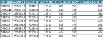
· Details of drillhole collar locations, including easting, northing, RL, azimuth, dip and total depth for material drillholes were reported in the CRL announcement dated 1 December 2025 and also provided below.
· Drillhole collar and survey data for the 2018 programme were reported in the CRL announcement dated 24 January 2019. · Drillhole collar data and intercepts for the 2017 programme were reported in CRL announcements dated 7 September, 1 November and 11 December 2018. · Historical SWM drilling locations and orientations have been presented in earlier announcements, including the 26 November 2015 release, and have been incorporated into the current database. · The exclusion of full tabulated data in this release is not considered material, as the relevant information has been previously reported and remains publicly available. |
|||||||||||||||||||||||||
|
Data aggregation methods |
· In reporting Exploration Results, weighting averaging techniques, maximum and/or minimum grade truncations (eg cutting of high grades) and cut-off grades are usually Material and should be stated. · Where aggregate intercepts incorporate short lengths of high grade results and longer lengths of low grade results, the procedure used for such aggregation should be stated and some typical examples of such aggregations should be shown in detail. · The assumptions used for any reporting of metal equivalent values should be clearly stated. |
· Exploration intercepts are reported as length-weighted averages of individual sample intervals. · No top-cutting or high-grade capping was applied in the reporting of exploration results. · Internal dilution is included where a geological basis exists for reporting a broader mineralised interval, particularly within the SVS. · For previously reported 2025 drilling samples, results are also expressed as WO₃ equivalent (WO₃Eq) values were calculated as: · WO₃Eq = WO₃ + (Sn × 0.82) + (Cu × 0.27) · For the 2026 MRE, all WO₃ equivalent (WO₃Eq) values were calculated as: · WO₃Eq = WO₃_% + (Sn_% × 0.403) + (Cu_% × 0.133) + (Ag_ppm × 0.0046) · The WO₃Eq formula used for previous 2025 exploration reporting differs from that used in the 2026 Mineral Resource Estimate, reflecting updated metal price assumptions, recoveries, and inclusion of Ag in the NSR-based formulation at the time. · The assumptions for the 2026 MRE WO₃Eq calculation are:
|
|||||||||||||||||||||||||
|
Relationship between mineralisation widths and intercept lengths |
· These relationships are particularly important in the reporting of Exploration Results. · If the geometry of the mineralisation with respect to the drill hole angle is known, its nature should be reported. · If it is not known and only the down hole lengths are reported, there should be a clear statement to this effect (eg 'down hole length, true width not known'). |
CRL drilling · The SVS mineralisation is interpreted as a broad tabular body with an internal plunge component. · Drillholes are generally oriented to intersect the mineralisation at high angles; however, due to the presence of multiple mineralised orientations, not all intersections are perpendicular. · Reported intercepts are generally downhole lengths (apparent thicknesses) unless otherwise stated. True widths are not always known at this stage. SWM drilling · Historical intersections are considered to represent full mineralised zones, and no material sampling bias is considered present. · Differences between downhole and true widths were considered in previous evaluations (SRK) and in current geological interpretation. |
|||||||||||||||||||||||||
|
Diagrams |
· Appropriate maps and sections (with scales) and tabulations of intercepts should be included for any significant discovery being reported These should include, but not be limited to a plan view of drill hole collar locations and appropriate sectional views. |
· Appropriate maps, plans, cross-sections and longitudinal sections illustrating drillhole locations, mineralised zones and geological interpretation are included in the announcement. |
|||||||||||||||||||||||||
|
Balanced reporting |
· Where comprehensive reporting of all Exploration Results is not practicable, representative reporting of both low and high grades and/or widths should be practiced to avoid misleading reporting of Exploration Results. |
· The announcement presents a balanced representation of exploration results, including both higher-grade and lower-grade intervals where relevant. · Where results are summarised, this is done in a manner that accurately reflects the overall tenor and variability of the mineralisation. |
|||||||||||||||||||||||||
|
Other substantive exploration data |
· Other exploration data, if meaningful and material, should be reported including (but not limited to): geological observations; geophysical survey results; geochemical survey results; bulk samples - size and method of treatment; metallurgical test results; bulk density, groundwater, geotechnical and rock characteristics; potential deleterious or contaminating substances. |
· All relevant and material exploration data, including geological interpretation, assay results and supporting technical information, have been presented in the announcement. · Additional technical studies, including metallurgical testwork, density data, geotechnical assessment and environmental considerations, are addressed elsewhere where relevant. |
|||||||||||||||||||||||||
|
Further work |
· The nature and scale of planned further work (eg tests for lateral extensions or depth extensions or large-scale step-out drilling). · Diagrams clearly highlighting the areas of possible extensions, including the main geological interpretations and future drilling areas, provided this information is not commercially sensitive. |
· Ongoing and planned work includes further drilling to test extensions of the mineralisation along strike and down dip, improve geological and grade continuity confidence, and support future Mineral Resource updates. · Additional studies, including metallurgical, geotechnical, environmental and mining assessments, are also planned to support advancement of the project. · Exploration targeting will continue to focus on extensions to the SVS and associated high-grade domains. |
|||||||||||||||||||||||||
Section 3 Estimation and Reporting of Mineral Resources
(Criteria listed in section 1, and where relevant in section 2, also apply to this section.)
|
Criteria |
JORC Code explanation |
Commentary |
||
|
Database integrity |
· Measures taken to ensure that data has not been corrupted by, for example, transcription or keying errors, between its initial collection and its use for Mineral Resource estimation purposes. · Data validation procedures used. |
· The drillhole data used for the Mineral Resource estimate are stored in a series of standalone Microsoft Excel spreadsheets containing the primary tables required for geological and resource modelling, including collar coordinates, downhole survey data, geological logging and assay data. · The dataset is segregated into two distinct groups: historical SWM drilling completed between 1980 and 1983 and CRL drilling undertaken during 2017 and 2018. As a result, duplicate tables exist for key datasets (e.g. collars, surveys and assays), which increases the complexity of data management. Despite these limitations, the dataset has undergone detailed validation and verification by Snowden Optiro and is considered suitable for Mineral Resource estimation. · The use of Microsoft Excel spreadsheets as the primary data storage medium means the database does not incorporate the controls typically provided by a relational drillhole database, such as version control, relational integrity, auditability or user permission controls. Snowden Optiro noted that this represents a potential risk to long-term data integrity and recommended migration to a secure relational database in future stages of the project. · The SWM drillhole data were digitised from original drill logs and drill plans by SRK in 2013. Snowden Optiro reviewed a selection of drillholes and confirmed that the collar coordinates recorded in the digital database correspond to those reported on the original logs and plans. · Downhole survey measurements for the SWM drilling were digitised from original drillhole sheets and converted from magnetic bearings to grid bearings using an appropriate declination correction. Snowden Optiro reviewed the original records and confirmed that the resulting drillhole traces are consistent with those shown on historical drilling plans. · The geological logging from SWM drilling was originally descriptive in nature and later digitized by SRK. Snowden Optiro notes that the digitisation process did not fully disaggregate lithological descriptions into discrete geological fields, resulting in some loss of detail within the digital database. · Snowden Optiro only used the split core assay samples for the 2026 modelling and estimate. All chip samples were excluded due to quality of sample collection methods. · The CRL drilling campaigns completed in 2017 and 2018 generated modern digital datasets including collar surveys, downhole survey measurements, geological logging and assay data. Collar positions were surveyed using differential GPS (RTK) and downhole surveys were collected using Reflex EZ-TRAC instruments at regular intervals. · Snowden Optiro noted several data management issues within the CRL dataset including irregular sampling intervals, unsampled sections within the mineralised system and the presence of duplicate sample identifiers within the assay table, which required review and correction. · Snowden Optiro undertook a review of the compiled drill database and associated source documentation. The database was considered suitable for use in Mineral Resource estimation; however, consolidation of SWM and CRL datasets into a single standardised relational database is recommended for future studies. · The CRL 2025 drilling data were reviewed by Snowden Optiro on an ongoing basis throughout the drilling programme as new data were generated. · A final validation of the dataset was undertaken once all drilling, logging, survey and assay data had been compiled prior to use in the MRE. Similar to the historic SWM and CRL datasets, the 2025 drillhole data were provided to Snowden Optiro in Microsoft Excel spreadsheet format. Assay data were manually transcribed by CRL from laboratory assay certificate spreadsheets into the project database. Due to the manual transcription process, Snowden Optiro undertook detailed verification of the compiled dataset. This included checking all assay values against the original laboratory certificates for every sample, together with database validation checks within Leapfrog Geo and Datamine Studio RM. · During validation, a small number of assay discrepancies (16 samples) were identified as transcription errors during data compilation. These were corrected by CRL and independently verified by Snowden Optiro against original laboratory certificates. Following correction, the dataset was confirmed to be accurate and suitable for Mineral Resource estimation. · Additional validation checks identified minor issues including small sample interval overlaps, duplicate entries and the absence of survey measurements at collar for some holes. These issues were reviewed and corrected by CRL prior to the finalisation of the dataset. · Snowden Optiro recommends that all drilling data be migrated to and maintained within a secure relational database to improve data integrity, auditability and version control for future exploration and resource estimation work. |
||
|
Site visits |
· Comment on any site visits undertaken by the Competent Person and the outcome of those visits. · If no site visits have been undertaken indicate why this is the case. |
· The Competent Person (CP), Mr Laurie Hassall, conducted multiple site visits to the Redmoor Project during the period of drilling. In total, Mr Hassall visited the project site on nine separate occasions between June 2025 and February 2026, including visits prior to the commencement of the 2025 drilling programme, during active drilling operations, and following completion of drilling. · During these visits, Mr Hassall undertook inspection and review of the drilling operations and sampling protocols implemented by CRL. This included direct observation of diamond drilling activities, inspection of drill core and core handling procedures, and verification of core logging, sampling and core cutting practices. · Site visits also included review of the geological logging procedures, inspection of sampled and unsampled core intervals, and confirmation that sampling procedures were consistent with the protocols described by CRL. Discussions were held with CRL geological staff regarding geological interpretation, drillhole targeting and the development of the geological model. · The site visits provided the CP with confidence that drilling, sampling, logging and data management practices implemented during the 2025 drilling programme were appropriate for the purposes of Mineral Resource estimation. |
||
|
Geological interpretation |
· Confidence in (or conversely, the uncertainty of ) the geological interpretation of the mineral deposit. · Nature of the data used and of any assumptions made. · The effect, if any, of alternative interpretations on Mineral Resource estimation. · The use of geology in guiding and controlling Mineral Resource estimation. · The factors affecting continuity both of grade and geology. |
· The mineralisation model used in the 2019 Mineral Resource Estimate (MRE) was reviewed by Snowden Optiro. While the previous model was considered appropriate given the geological understanding and drilling information available at the time, Snowden Optiro determined that a complete re-modelling of the geological and mineralisation interpretation was warranted for the current MRE update. This re-modelling incorporated additional geological understanding as well as the inclusion of validated historical SWM drilling data and new CRL drilling completed in 2025. · Snowden Optiro undertook the development of the updated geological and mineralisation models in Leapfrog Geo 2025.1, with technical input and geological review provided by CRL. While a mineralisation model from the 2019 MRE was available for reference, no comprehensive geological model had previously been constructed for the deposit. As such, the current geological model represents the first fully integrated geological interpretation for the Redmoor deposit. · Detailed review of drilling data, drill core observations, historical logging information and structural measurements confirmed that the previously interpreted High Grade Domains (HGDs) were generally valid. However, reinterpretation of the data demonstrated that some HGDs are tungsten-dominant while others are tin-dominant. The updated model therefore differentiates these domains based on individual metal grades and geological observations rather than the use of a metal equivalent grade. · High-grade veins were modelled as narrow structures within the broader Sheeted Vein System (SVS). Domain interpretation incorporated assay data, structural measurements and geological logging information. A nominal minimum modelling width of 1.5 m was applied together with guide cut-off grades of approximately 0.3% WO₃ for tungsten-dominant domains and 0.3% Sn for tin-dominant domains. Veins were interpreted on a section-by-section basis using Leapfrog vein modelling tools following interval selection based on geological and assay criteria. · A key enhancement to the updated model is the incorporation of geological logging and assay data from historical SWM drilling, which had not previously been used to inform the mineralisation model. This enabled the interpreted mineralised structures and geological units to be extended beyond the limits of the 2019 model where supported by the historical data. · In addition to the high-grade veins, the updated interpretation incorporates a low-grade mineralised envelope associated with the broader SVS as well as a distinct copper-dominant domain within the SVS that is separate from the tungsten and tin high-grade structures. These domains were interpreted using combinations of assay data, metal-equivalent grade thresholds and geological logging criteria. The copper-dominant domain was generated using an indicator-based modelling approach within Leapfrog. · The interpretation also incorporates historically mined Sn-Cu dominant lodes identified from limited intercepts in historical SWM and CRL drillholes. These structures reflect known mineralised trends within the broader Kit Hill mining district. · The geological model incorporates the principal lithological units and intrusive bodies recognised within the Redmoor area. These include the Kit Hill granite, granite dykes, elvan quartz porphyry rhyolites, aplites, mafic or tuffaceous interbeds, and the surrounding pelitic country rocks. Geological interpretation was informed by drillhole logging data, structural measurements, regional geological understanding and recent gravity geophysical surveys which assist in constraining the geometry of the granite intrusion. · Weathering surfaces including the Base of Complete Oxidation (BOCO) and Top of Fresh Rock (TOFR) were interpreted based on weathering information recorded during geological logging. · Geological interpretation of the deposit is considered robust and well supported by the available drilling data and regional geological knowledge. Redmoor lies within the historically mined Kit Hill district where tin, copper and arsenic mineralisation were exploited during the nineteenth and early twentieth centuries. The regional geology is well documented by the British Geological Survey and supported by extensive geological mapping, GIS datasets and geophysical data across the licence area. · Continuity of mineralised structures has been further supported by the 2025 drilling programme, which targeted gaps within the previous 2019 model interpretation. The updated mineralisation model was initially constructed prior to the completion of the 2025 drilling and subsequently updated to incorporate the new data. Only minor modifications to the interpreted structures were required following incorporation of the new drilling results, supporting the robustness of the interpretation. · Based on the available geological, geochemical and structural data, Snowden Optiro considers the geological and mineralisation interpretations to have a moderate to high level of confidence in the overall geological framework, with local uncertainty remaining due to drill spacing and geological complexity. No materially different alternative interpretations are currently considered likely to significantly impact the MRE. · Continuity of mineralisation and grade within the principal structures is considered good and is supported by drilling density and geological understanding of the SVS mineralisation style. The current drillhole spacing is considered sufficient to support the interpreted continuity of both geology and grade for the purposes of the MRE. |
||
|
Dimensions |
· The extent and variability of the Mineral Resource expressed as length (along strike or otherwise), plan width, and depth below surface to the upper and lower limits of the Mineral Resource. |
· The principal mineralised system at Redmoor is the Sheeted Vein System (SVS), which forms the main component of the Mineral Resource. The SVS has been interpreted to extend for approximately 1,000 m along strike and to a down-dip vertical extent of approximately 760 m below surface, equivalent to approximately 560 m below the crown safety pillar. The SVS strikes approximately 070° and dips at approximately 70° to the north. The overall thickness of the mineralised SVS envelope varies along strike and down dip but averages approximately 80 m. · Sixteen High Grade Domains (HGDs) have been modelled within and largely enveloped by the broader SVS mineralised system. These HGDs follow the same general structural orientation as the SVS, with similar strike and dip, although individual veins exhibit variability in their interpreted strike and down-dip continuity. · The HGDs collectively form a package of narrow veins within the SVS and generally extend along the same structural trend. In some areas, individual HGDs extend slightly beyond the interpreted limits of the SVS envelope by up to approximately 40 m down dip. · The HGDs also exhibit a subtle down-plunge continuity towards the west, broadly reflecting the geometry of the underlying Kit Hill granite intrusion which dips beneath the mineralised structures. · Individual HGDs are typically narrow, with an average true thickness of approximately 2 m, although thickness varies both between veins and along the length of individual structures. |
||
|
Estimation and modelling techniques |
· The nature and appropriateness of the estimation technique(s) applied and key assumptions, including treatment of extreme grade values, domaining, interpolation parameters and maximum distance of extrapolation from data points. If a computer assisted estimation method was chosen include a description of computer software and parameters used. · The availability of check estimates, previous estimates and/or mine production records and whether the Mineral Resource estimate takes appropriate account of such data. · The assumptions made regarding recovery of by-products. · Estimation of deleterious elements or other non-grade variables of economic significance (eg sulphur for acid mine drainage characterisation). · In the case of block model interpolation, the block size in relation to the average sample spacing and the search employed. · Any assumptions behind modelling of selective mining units. · Any assumptions about correlation between variables. · Description of how the geological interpretation was used to control the resource estimates. · Discussion of basis for using or not using grade cutting or capping. · The process of validation, the checking process used, the comparison of model data to drill hole data, and use of reconciliation data if available.
|
· Mineralisation modelling was conducted in Leapfrog Geo 2025.1. HGDs as described were modelled individually and interpretations were performed on a section by section basis. A 1.5 m nominal minimum width was used and the tungsten HGDs were modelled using geological, structural and grade data. A nominal 0.3% WO3 grade was implemented as a modelling cutoff. A similar technique was used for the tin dominant HGDs, whereby a 0.3% Sn grade was used. The low grade SVS has been modelled in a similar manner, using a 0.3% WO3 Eq grade to ensure all anomalous mineralisation was captured. The medium grade copper dominant domain was modelled using the Indicator modeling technique in Leapfrog Geo and using a 0.3% WO3 Eq cut-off. · Mineralisation models were used as mineralisation domains for estimation and the full list is provided below. A total of 11 tungsten HGDs, 5 tin HGDs, a medium grade SVS domain (8001), a low grade SVS envelope (9001) and 3 tin/copper lodes.
· All estimation was performed in Datamine Studio RM 3.1.381 and geostatistics and variography was performed in Datamine Supervisor v9.2. The grades estimated included WO3, Sn, Cu, Ag and As. · Drillhole raw sample statistics were interrogated and then coded with the mineralisation, geology and weathering domains. Raw coded drillhole interval lengths were interrogated and it was determined that the most appropriate composite length was 2 m, with over 40% of raw lengths at 2 m overall and 30% within the HGDs only. This is compared to 1 m raw lengths at 18% overall and 35% within the HGDs. · Following statistical review of raw sample data, any samples with 0 grades, negative grade and below detection limit values were reset to appropriate values based on detection limits and statistical review, using standard industry practice to ensure unbiased estimation. · All samples were assayed for WO₃, Sn and Cu (7,247 samples), while 5,211 samples were analysed for As and 4,360 for Ag. Correlation analysis undertaken on all analytes confirmed a strong relationship between Ag and Cu, consistent with observations from historical CRL datasets. On this basis, a linear regression of Ag against Cu was applied to estimate Ag values where assays were absent. The regression relationship was reviewed and considered sufficiently robust for use in estimation, with no material bias introduced at a global scale. This approach ensures a more robust and unbiased dataset, noting that historical 2017-2018 CRL drilling preferentially assayed Ag only in intervals with elevated Cu grades. No backfilling was applied to As, as it did not demonstrate a reliable correlation with other analytes. · Compositing was performed at 2 m using the Datamine mode tool = 1, which forces all samples to be included in the composites by adjusting the target composite length, while keeping its length as close as possible to 2 m. This avoided the creation of very short length remnant intervals that may have an undue affect on the grade estimate. · Raw and composite statistics were reviewed for each domain and analyte to ensure appropriate statistical representation and suitability for geostatistical analysis and estimation. · Boundary/contact analysis was undertaken for all high-grade domains (HGDs) in contact with the surrounding medium- and low-grade SVS domains to determine the most appropriate estimation approach. This assessment was completed for all estimated analytes and indicated that hard domain boundaries are appropriate across all domains and variables. · Top-cut analysis was carried out for all analytes, including assessment on grouped domains (e.g. all tungsten HGDs) where sample populations were limited. The analysis was undertaken in Supervisor and supported by review of log probability plots, histograms, mean and variance plots, and cumulative metal curves. Statistical top-cutting was applied to all analytes, with selected top-cut values and their impact on mean grades detailed below. The influence on coefficients of variation was also reviewed for each analyte.
· Variography was undertaken for all analytes on a grouped domain basis (e.g. combined tungsten HGDs) due to limited sample support within individual domains. Across all analytes, a consistent principal continuity direction was identified, plunging down-dip to the west, broadly reflecting the geometry of the underlying granite contact. WO₃ displayed a particularly strong but more discrete down-dip continuity within the HGDs. Variogram modelling was completed in Supervisor, with principal, semi-major and minor directions defined using continuity fan analysis. Nugget effects were high for WO₃ and moderately high for Sn, Cu, Ag and As. Variogram ranges varied by analyte and domain; however, typical ranges included 380 m (major) and 240 m (semi-major) for WO₃ in tungsten HGDs, 390 m and 240 m respectively for Sn in tin HGDs, and 330 m and 240 m for Cu within the SVS Cu domain, all reflecting a strong down-dip westerly plunge other than WO₃. · Block model parent cell dimensions were defined based on drillhole spacing and supported by Kriging Neighbourhood Analysis (KNA) of WO₃ within the tungsten HGDs. A parent cell size of 30 m (X) × 15 m (Y) × 15 m (Z) was adopted. Subcelling to a minimum of 2.5 m × 1.25 m × 1.25 m was implemented to adequately represent the geometry and continuity of the narrower HGDs. Volume reconciliation between wireframes and the block model was completed for all domains, with an average variance of approximately 0.01%, indicating a high level of volumetric consistency. · True dip and strike orientations were estimated into the block model using planar mid-surface wireframes for each domain. This enabled the application of Dynamic Anisotropy (DA) during estimation, whereby the search ellipse is locally oriented according to the geometry of each block. · Grade estimation was undertaken using Ordinary Kriging (OK) within Datamine Studio RM (COKRIG). Each domain was estimated independently using hard boundaries, with only composites from within each domain used for estimation to prevent sample sharing between HGDs. Estimation parameters were generally derived from grouped domain analyses, although some domains required locally optimised parameters. All search ellipses were oriented using DA. Search distances were applied progressively, with the first pass set at approximately one-third of the variogram range, increasing to 1.5×, 2.5× and ~5× for subsequent passes to ensure full model coverage. Only search passes 1 to 3 were classified as Inferred. Minimum and maximum sample numbers, as well as maximum samples per hole, were primarily informed by KNA and varied by analyte and domain. A secondary, distance-based soft cap was applied to WO₃ within the tungsten HGDs to limit the local influence of high-grade values (3%). One domain (1011) contained insufficient data to support estimation and was therefore assigned a mean grade and excluded from the Mineral Resource. · The grade estimates were statistically validated for each analyte and domain through comparison of composite means, declustered means, and block model means. Additional validation included histogram and QQ plot analysis. Local validation was undertaken using swath plots in all principal directions to assess smoothing and identify any potential grade bias. All estimates were also visually validated against drillhole composites within Datamine. · Density data, comprising 2,068 measurements across mineralised domains, was reviewed and processed in Supervisor. Samples averaged approximately 0.23 m in length. A length-weighted mean density was assigned to each mineralised domain and lithological domain. Data density was insufficient to support spatial estimation or regression of density. |
||
|
Moisture |
· Whether the tonnages are estimated on a dry basis or with natural moisture, and the method of determination of the moisture content. |
· All tonnages are reported as dry tonnes |
||
|
Cut-off parameters |
· The basis of the adopted cut-off grade(s) or quality parameters applied. |
· The Mineral Resource is reported above a Net Smelter Return (NSR) cut-off of US$110/t and constrained within underground Mineable Shape Optimiser (MSO) stope shapes. This approach ensures that only material with reasonable prospects for eventual economic extraction (RPEEE) is reported. · NSR values were calculated on a block-by-block basis using estimated grades for WO₃, Sn, Cu, Ag and As, incorporating metal prices, metallurgical recoveries, concentrate payabilities, treatment and refining charges, royalties, and penalties. This multi-element NSR approach reflects the polymetallic nature of the Redmoor deposit and provides a consistent economic basis for reporting. · The NSR calculation includes contributions from WO₃, Sn, Cu and Ag, with Cu and Ag recovered to a copper concentrate stream. An arsenic penalty is applied to the copper concentrate based on arsenic content, and negative Cu contributions are constrained to zero to ensure that penalty-dominated material does not artificially reduce block value. · The NSR calculation is as follows: US$NSR/t=((WO₃_%x550)+(Sn_%x222)+MAX(((Cu_%x73)+(Ag_ppmx1.02)-(As_%x25)),0) · Metal price assumptions include US$850/mtu for WO₃ (APT), US$38,000/t for Sn, US$11,000/t for Cu and US$75/oz for Ag. Metallurgical recoveries and payabilities are derived from recent (2025-2026) testwork and reflect a conventional processing flowsheet producing WO₃, Sn and Cu concentrates. Cu recoveries were previously assumed but are now based on recent metallurgical testwork. · The selected NSR cut-off of US$110/t reflects estimated operating costs, including underground mining, processing, water treatment and general and administrative costs. The cut-off is considered reasonable for reporting the Mineral Resource and has been supported by grade-tonnage sensitivity analysis. · The use of an NSR cut-off, rather than a single metal grade, ensures that all payable metals and penalty elements are appropriately accounted for in the economic assessment. |
||
|
Mining factors or assumptions |
· Assumptions made regarding possible mining methods, minimum mining dimensions and internal (or, if applicable, external) mining dilution. It is always necessary as part of the process of determining reasonable prospects for eventual economic extraction to consider potential mining methods, but the assumptions made regarding mining methods and parameters when estimating Mineral Resources may not always be rigorous. Where this is the case, this should be reported with an explanation of the basis of the mining assumptions made. |
· The Mineral Resource has been reported assuming underground mining, with sublevel open stoping (SLOS) considered the most appropriate mining method. This assumption is based on the geometry of the mineralisation, which comprises moderately to steeply dipping, laterally continuous sheeted vein systems and discrete high-grade domains with sufficient thickness to support bulk underground extraction. This is also the method assumed in the 2020 Scoping Study. · RPEEE has been demonstrated through the generation of optimised underground stope shapes using the Datamine MSO algorithm. The optimisation incorporates both economic parameters (via NSR) and practical mining constraints to define potentially mineable volumes. · Key mining parameters applied during optimisation include a minimum mining width of 3 m, minimum stope panel dimensions of approximately 10 m (strike length) by 20 m (height), a minimum mining dip of 40°, and a pillar dimension of 6 m. These parameters are consistent with typical SLOS operations and reflect the expected geotechnical and operational constraints of the deposit. · An allowance for internal dilution of 1 m has been applied during optimisation to account for overbreak and practical mining considerations. A mining recovery factor of 95% has also been assumed. These parameters are considered reasonable for a conceptual underground operation but have not yet been validated by detailed geotechnical or mine design studies. · A 200 m crown pillar has been applied below surface (above −20 mRL) to reflect potential planning and permitting constraints associated with underground mining beneath surface dwellings. This constraint ensures that reported Mineral Resources are limited to areas where there is a reasonable expectation that underground mining could be permitted. Previous Mineral Resources for Redmoor have been reported to surface. · Mineral Resources are reported on an undiluted basis within MSO shapes; however, dilution and recovery assumptions have been incorporated into the optimisation process to support the RPEEE assessment. A diluted inventory is presented for context but is not reported as part of the Mineral Resource. · The mining assumptions are based on scoping-level studies and conceptual design parameters. While considered appropriate for Mineral Resource reporting, these assumptions are not yet supported by detailed mine design, scheduling, or geotechnical assessment and are expected to be refined in future studies. |
||
|
Metallurgical factors or assumptions |
· The basis for assumptions or predictions regarding metallurgical amenability. It is always necessary as part of the process of determining reasonable prospects for eventual economic extraction to consider potential metallurgical methods, but the assumptions regarding metallurgical treatment processes and parameters made when reporting Mineral Resources may not always be rigorous. Where this is the case, this should be reported with an explanation of the basis of the metallurgical assumptions made. |
· Metallurgical assumptions applied in the MRE are based on a comprehensive metallurgical testwork programme completed in February 2026. The results of this programme underpin the recovery, payability and processing assumptions used in the NSR calculation and are considered appropriate for the current level of study. · This testwork represents the first integrated, lab-scale flowsheet developed for the Redmoor deposit, focusing on SVS mineralisation, which constitutes the majority of the Mineral Resource. The programme provides an initial basis for understanding metallurgical performance across the primary mineralisation style. · Testwork was undertaken on a composite sample designed to be representative of the overall Redmoor deposit, incorporating average grades of the key payable metals (WO₃, Sn, Cu and Ag) and deleterious metals (As). While this provides a robust indication of overall metallurgical performance, it does not yet capture potential variability between domains or grade ranges within the deposit. · The flowsheet evaluated includes conventional processing stages comprising crushing and screening, heavy liquid separation (HLS), comminution testing, flotation (targeting Cu and Ag recovery and removal of deleterious elements such as As), followed by gravity and magnetic separation to recover WO₃ and Sn into saleable concentrates. · The testwork demonstrated that WO₃, Sn and Cu can be recovered into separate concentrate streams using conventional processing techniques, supporting the assumptions applied in the NSR calculation. |
||
|
Environmental factors or assumptions |
· Assumptions made regarding possible waste and process residue disposal options. It is always necessary as part of the process of determining reasonable prospects for eventual economic extraction to consider the potential environmental impacts of the mining and processing operation. While at this stage the determination of potential environmental impacts, particularly for a greenfields project, may not always be well advanced, the status of early consideration of these potential environmental impacts should be reported. Where these aspects have not been considered this should be reported with an explanation of the environmental assumptions made. |
· Environmental and permitting requirements for the Redmoor Project are governed by UK regulatory authorities, including Cornwall Council (Mineral Planning Authority), the Environment Agency and the Health and Safety Executive. Mining operations will require appropriate permits and ongoing monitoring to manage potential impacts such as water discharge, noise, dust and vibration. · A 200 m crown pillar has been applied below surface (above −20 mRL) to reflect potential environmental, social and planning constraints associated with underground blasting beneath surface dwellings. This constraint ensures that reported Mineral Resources are limited to areas where there is a reasonable expectation that mining could be permitted. · The project is located within a historic mining district and the Cornwall and West Devon Mining Landscape (UNESCO World Heritage Site). While this does not preclude development, it requires appropriate management of heritage and environmental impacts. · Baseline environmental information is available from historical studies and limited recent work; however, additional data collection and updated studies will be required to support future environmental impact assessment and permitting. · The site includes previously disturbed ground associated with historical mining and is not located within an Area of Outstanding Natural Beauty, although such designations occur nearby. · Community engagement to date indicates general support, with key concerns including subsidence, vibration and traffic. · Environmental assumptions are considered appropriate for Mineral Resource reporting; however, further detailed studies, permitting and stakeholder engagement will be required to support future project development. |
||
|
Bulk density |
· Whether assumed or determined. If assumed, the basis for the assumptions. If determined, the method used, whether wet or dry, the frequency of the measurements, the nature, size and representativeness of the samples. · The bulk density for bulk material must have been measured by methods that adequately account for void spaces (vugs, porosity, etc), moisture and differences between rock and alteration zones within the deposit. · Discuss assumptions for bulk density estimates used in the evaluation process of the different materials. |
· Bulk density values were determined from drill core measurements and applied on a domain basis within the block model. A total of 2,068 density measurements were available across mineralised domains, with an average sample length of approximately 0.23 m. · Density measurements were undertaken using the water immersion method (Archimedes' principle), whereby dry, saturated surface-dry, and submerged weights are measured to calculate bulk density. This method is considered appropriate for competent, low-porosity drill core and provides an accurate determination of in-situ density. · Core samples were oven dried prior to measurement to remove moisture and ensure consistency. For porous, weathered or friable samples where water ingress could bias results, an alternative wax-coating method was applied to prevent water penetration and ensure representative density values. · Sample selection for density measurement was undertaken to ensure representation across all geological domains, including mineralised zones, host lithologies and alteration types. Measurements were taken across a range of depths and grades to avoid bias and to capture variability within each domain. · QAQC procedures included routine calibration of balances using certified standards, measurement of density standards at the start of each session, and duplicate measurements at a rate of approximately 10% to assess precision and reproducibility. · The density determination methods account for void spaces and porosity through the use of appropriate measurement techniques (standard immersion or wax coating), and by ensuring samples are representative of the in-situ material. · Density data were reviewed and processed in Supervisor, and length-weighted mean densities were assigned to each geological domain. Due to the available data density, bulk density was not estimated spatially within the block model, and no regression relationships with grade or other variables were applied. · The adopted domain-based density values are considered appropriate for the current level of study; however, additional density measurements are recommended to further improve spatial confidence and support future Mineral Resource updates. |
||
|
Classification |
· The basis for the classification of the Mineral Resources into varying confidence categories. · Whether appropriate account has been taken of all relevant factors (ie relative confidence in tonnage/grade estimations, reliability of input data, confidence in continuity of geology and metal values, quality, quantity and distribution of the data). · Whether the result appropriately reflects the Competent Person's view of the deposit. |
· The Mineral Resource has been classified as entirely Inferred. The classification is based on a combination of geological confidence, drillhole spacing, data quality, and continuity of mineralisation and grade, and has been applied on a domain-by-domain basis. · The Inferred classification reflects the current level of confidence in the geological interpretation and grade estimation, with mineralisation defined by drilling at approximate spacings of 100-200 m along strike and 60-120 m down dip. While this drilling supports the overall continuity of the mineralised system, it is insufficient to support higher-confidence classifications due to local geological complexity and grade variability. · Appropriate account has been taken of all relevant factors at the Mineral Resource stage, including the reliability and quality of the input data, which comprises a combination of historic and recent drilling supported by QAQC procedures and validation of assay data. The estimation methodology, including domaining, variography, and kriging parameters, has been applied consistently and is considered appropriate for the style of mineralisation. · The classification also reflects uncertainty in the estimation of tonnage and grade arising from variable drill spacing and localised grade variability within high-grade domains. These factors contribute to uncertainty in the continuity of both geometry and grade at a local scale. · The quantity, quality and spatial distribution of the data are considered sufficient to support an Inferred Mineral Resource classification, but are not yet adequate to demonstrate the level of confidence required for Indicated classification. Additional infill drilling and further data collection, particularly to improve spatial continuity and density confidence, would be required to support any future upgrade in classification. · The Competent Person considers that the classification appropriately reflects their view of the deposit, the available data, and the level of confidence in the geological interpretation and grade estimation. |
||
|
Audits or reviews |
· The results of any audits or reviews of Mineral Resource estimates. |
· No independent third-party audits of the Mineral Resource estimate have been completed, other than internal reviews by Snowden Optiro and previous reviews of historical data by SRK. |
||
|
Discussion of relative accuracy/ confidence |
· Where appropriate a statement of the relative accuracy and confidence level in the Mineral Resource estimate using an approach or procedure deemed appropriate by the Competent Person. For example, the application of statistical or geostatistical procedures to quantify the relative accuracy of the resource within stated confidence limits, or, if such an approach is not deemed appropriate, a qualitative discussion of the factors that could affect the relative accuracy and confidence of the estimate. · The statement should specify whether it relates to global or local estimates, and, if local, state the relevant tonnages, which should be relevant to technical and economic evaluation. Documentation should include assumptions made and the procedures used. · These statements of relative accuracy and confidence of the estimate should be compared with production data, where available. |
· No quantitative assessment of estimation uncertainty has been undertaken, and confidence is expressed qualitatively, consistent with the Inferred classification. · The relative accuracy and confidence of the Mineral Resource estimate are considered appropriate for an Inferred Mineral Resource classification under the JORC Code (2012). The estimate is considered reliable at a global scale for the purposes of strategic evaluation, but not at a local scale for detailed mine planning or grade control. · The level of confidence in the estimate reflects the current drillhole spacing (typically 100-200 m along strike and 60-120 m down dip), which is sufficient to demonstrate overall geological continuity but does not adequately constrain local variability in geometry and grade. · Key factors that may impact the relative accuracy of the estimate include the variability in vein thickness and grade distribution within high-grade domains, and the variable spatial distribution of drilling across the deposit. Additional uncertainty arises from the use of domain-based density values rather than spatially estimated density. · The estimation approach, including geological domaining, variography, ordinary kriging, and the application of dynamic anisotropy, is considered appropriate for the style of mineralisation. Validation of the estimate was undertaken through comparison of composite, declustered and block model means, as well as visual validation and swath plot analysis, which indicate that the estimate is globally unbiased. · The Mineral Resource has been constrained using an NSR-based cut-off and reported within MSO stope shapes, providing additional confidence that the reported tonnes and grades reflect material with reasonable prospects for eventual economic extraction. · The estimate is not suitable for detailed mine planning and should not be used for production forecasting. Additional infill drilling, improved data density, and further refinement of geological and density models would be required to improve confidence and support higher classification categories. · No production data are available for reconciliation, and therefore no quantitative assessment of accuracy against production has been undertaken. |
||
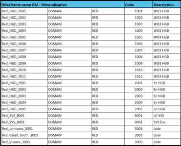
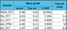
RNS may use your IP address to confirm compliance with the terms and conditions, to analyse how you engage with the information contained in this communication, and to share such analysis on an anonymised basis with others as part of our commercial services. For further information about how RNS and the London Stock Exchange use the personal data you provide us, please see our Privacy Policy.


Latest directors dealings
- 1 day ago Workspace Group
- 1 day ago Talon Resources Plc
- 1 day ago Vodafone Group
- 1 day ago Synthomer
- 1 day ago Ondo Insurtech