Kasiya MRE Significantly Upgraded Ahead of DFS
Summary by AI BETAClose X

NEWS RELEASE I 18 MARCH 2026
KASIYA MINERAL RESOURCE ESTIMATE SIGNIFICANTLY UPGRADED AHEAD OF DFS
Measured & Indicated Resources Increase by 32% Cementing Kasiya as the World's Largest Natural Rutile Deposit
KEY HIGHLIGHTS
· Total Rutile Mineral Resource increases to 2.1 billion tonnes at 0.96% rutile for 20.3Mt contained rutile with 0.95% TGC for 20.0Mt contained graphite (M,I&I)
· Measured and Indicated (M&I) contained rutile surges 32% to 16.1Mt (1.6 billion tonnes at 0.98% rutile) - a material increase in resource confidence ahead of DFS
· Measured Resource planned to be mined and processed in first six years of operations - highest confidence JORC Code category, achieved at Kasiya for the first time
· Resource upgrade delivers the classification standard required for bankable DFS - a critical milestone on the path to project financing
Sovereign Metals Limited (ASX:SVM; AIM:SVML; OTCQX:SVMLF) (Sovereign or the Company) is pleased to announce an updated Mineral Resource Estimate (MRE) for its flagship Kasiya Rutile-Graphite Project (Kasiya or Project) in Malawi.
The updated MRE will serve as the resource base for the Kasiya Definitive Feasibility Study (DFS) mine schedule, replacing the previous April 2023 MRE (Previous MRE).
Combined Measured and Indicated rutile Resources have grown 38% to 1,652Mt, now representing 77% of the total Resource base. This material improvement in Resource confidence reflects the extensive infill drilling programs completed and provides a robust foundation for the forthcoming DFS. Importantly, Kasiya has achieved a Measured Resource for the first time, which represents at least the first six years of planned operations.
Managing Director and CEO Frank Eagar commented:
"This updated MRE is a significant milestone for Sovereign as we advance Kasiya through the Definitive Feasibility Study. The 32% increase in Measured and Indicated contained rutile, together with our first-ever Measured Resource, reflects both the quality of our geological dataset and the exceptional nature of this deposit. The rigour of the updated resource estimation gives our strategic and commercial partners and us high confidence in the resource base underpinning our potential mine schedule. Kasiya remains unmatched globally as a source of natural rutile, and this MRE update reinforces its potential as a long-life, low-cost supplier to critical global supply chains."
UPDATED MINERAL RESOURCE ESTIMATE
Table 1: Kasiya Rutile Mineral Resource Estimate (March 2026)
|
Class |
Tonnes (Mt) |
Rutile Grade (%) |
Rutile (Mt) |
TGC (%) |
TGC (Mt) |
Rutile Eq. (%) |
|
Measured |
107 |
1.05 |
1.12 |
1.56 |
1.67 |
1.94 |
|
Indicated |
1,545 |
0.97 |
14.99 |
1.05 |
16.26 |
1.57 |
|
Total M&I |
1,652 |
0.98 |
16.12 |
1.09 |
17.93 |
1.60 |
|
Inferred |
452 |
0.91 |
4.12 |
0.45 |
2.02 |
1.17 |
|
Total Rutile MRE |
2,105 |
0.96 |
20.24 |
0.95 |
19.95 |
1.51 |
Note: Rutile Mineral Resource defined from a pit shell with mineralisation defined as >= 0.75% Rut95 for the pit shell optimisation run. A rutile concentrate net price of US$1,400 was used to determine economic value. Graphite had no value for this run. The Rutile MRE is reported based on all rutile mineralisation >=0.4% Rut95 within the optimised pit shell. Any apparent differences in totals are due to rounding.
Table 2: MRE Comparison - Previous vs. Updated
|
Metric |
Previous MRE |
Updated MRE |
Change |
|
Total Resource Tonnes (Mt) |
1,809 |
2,105 |
+16% |
|
Measured & Indicated Tonnes (Mt) |
1,200 |
1,652 |
+38% |
|
M&I Contained Rutile (Mt) |
12.2 |
16.1 |
+32% |
|
Total Contained Rutile (Mt) |
17.9 |
20.2 |
+13% |
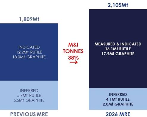
Figure 1: Increase in Kasiya MRE across categories
The updated MRE provides the resource foundation for the upcoming DFS mine schedule and mine optimisation study. The step-up in Measured and Indicated resource confidence is a critical input for the DFS, enabling the Company to present a resource base with the classification level required for bankable project financing and offtake discussions.
Sovereign's DFS is progressing across all workstreams including mining, processing, infrastructure, environmental and social studies, and commercial arrangements.
MRE EMPHASISES SOVEREIGN'S STRATEGIC SIGNIFICANCE FOR GLOBAL SUPPLY CHAINS
Kasiya is a uniquely diversified source of critical minerals essential to defence, industrial and energy security. The updated MRE demonstrates Kasiya's potential to supply titanium-bearing rutile and graphite for several decades and its position as the world's single most strategically important source of rutile.
Natural rutile is a critical mineral essential to titanium metal production for aerospace, defence and medical applications. According to leading titanium consultants TZ Minerals International Pty Ltd (TZMI), demand for rutile from the titanium metals industry is forecast to grow 3% annually, while global supply is expected to decline by 7% per year over the next decade. The market faces a widening structural deficit.
Natural rutile commands a significant premium over alternative titanium feedstocks due to its superior grade (95%+ TiO₂), lower processing costs, and smaller environmental footprint. With no meaningful domestic production in key consuming nations, Kasiya's scale and quality position it as the single most strategically important source of natural rutile outside of current producing regions.
With the updated MRE, Kasiya is positioned to address this critical supply gap at a time when new sources of natural rutile are urgently needed.
The graphite resource further enhances Kasiya's strategic value with a second critical mineral. With graphite demand forecast to grow 9% annually across battery and industrial applications (Benchmark Mineral Intelligence), the Project's 20.0Mt contained graphite provides significant exposure to a valuable by-product.
KASIYA MRE TECHNICAL DETAILS
The Kasiya MRE has been prepared by Sovereign under guidance by MSA Group and is reported in accordance with the JORC Code (2012) (JORC).
Rutile mineralisation lies in laterally extensive, near-surface, flat "blanket" style bodies in areas where the weathering profile is preserved and not significantly eroded. The high-grade zones are relatively geologically consistent with limited variability along and across strike. The mineralisation style is illustrated best in Figure 2 below.
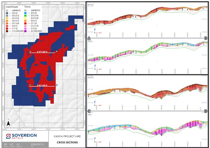
Figure 2: MRE with E-W Cross Sections 8,479,200N (A-B) and E-W Cross Sections 8,467,600N (C-D) (cross section are at +/- 100m with 30x vertical exaggeration)
SUMMARY OF RESOURCE ESTIMATE REPORTING CRITERIA
As per ASX Listing Rule 5.8 and the JORC reporting guidelines, a summary of the material information used to estimate the MRE is detailed below.
Geology
Regional Geology
The greater part of Malawi is underlain by crystalline Precambrian to lower Palaeozoic rocks referred to as the Malawi Basement Complex. In some parts, these rocks have been overlain unconformably by sedimentary and volcanic rocks ranging in age from Permo-Triassic to Quaternary. The Basement complex has undergone a prolonged structural and metamorphic history dominated by uplift and faulting, resulting in the formation of the Malawi Rift Valley.
Kasiya is located on the Lilongwe Plain, which is underlain by the Basement Complex paragneisses and orthogneisses, which are part of the Mozambique Belt. The bulk of the gneisses are semi-pelitic, but there are bands of psammitic and calcareous rocks that have been metamorphosed under high pressure and temperature conditions to granulite facies.
Interspersed within the paragneiss units are lesser orthogneisses, often cropping out as conspicuous tors, as well as amphibolites, pegmatites and minor mafic to ultramafic intrusions. Foliation and banding in the gneisses have a broad north-south strike over the general area. Thick residual soils and pedolith with some alluvium overlie the gneisses and include sandy, lateritic and dambo types.
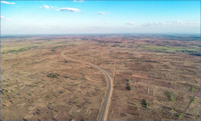
Figure 3: Drone photo above the Kasiya Deposit showing the open, flat terrain
Project Geology
Sovereign's tenure covers 644 km2 over an area to the north, west and south of Malawi's capital city, covering the Lilongwe Plain. The topography is generally flat to gently undulating, and the underlying geology is dominated by paragneiss with pelitic, psammitic and calcareous units.
A particular paragneiss unit is rich in rutile and graphite and is the primary source of both minerals in the area. This area was deeply weathered during the Tertiary, and rutile concentrated in the upper part of the weathering profile, forming residual placers, such as the Kasiya deposit. Once this material is incised and eroded, it is transported and deposited into wide, regional braided river systems, forming alluvial heavy mineral placers such as the Bua Channel.
Kasiya Deposit Geology
The high-grade rutile deposit at Kasiya is best described as a residual placer, or otherwise known as an eluvial heavy mineral deposit. It is formed by weathering of the primary host rock and concentration in place of heavy minerals, as opposed to the high-energy transport and concentration of heavy minerals in a traditional placer.
The presence of abundant kyanite and graphite in the host material suggests a meta-sedimentary protolith. The protolith likely started with a 0.5-1.5Ga basin that also experienced a consistent influx of titanium minerals.
These sedimentary rocks were subject to granulite facies metamorphism under reduced conditions in the Pan-African Orogeny. The metamorphic facies, reduced environment, relatively high titanium content and low iron content resulted in rutile being the most stable titanium mineral under these conditions. Slow exhumation and cooling then resulted in re-crystallisation as paragneisses containing coarse rutile and graphite.
The final and most important stage of rutile enrichment came as tropical weathering during the Tertiary depleted the top ~8m of physically and chemically mobile minerals. This caused significant volume loss and concurrent concentration of heavy resistate minerals, including rutile and kyanite.
Rutile mineralisation therefore lies in laterally extensive, near-surface, flat "blanket" style bodies in areas where the weathering profile is preserved. The Kasiya deposit shows widespread, high-grade mineralisation commonly grading 1.2% to 2.0% rutile in the top 3-5m from surface. Moderate grade mineralisation, generally grading 0.5% to 1.2% rutile, commonly extends from 5m to the base of the soft saprolite unit to typically 20-30m depth, where it terminates on the hard saprock basement.
Graphite generally occurs in broad association with rutile. However, it is depleted in the top 3-5m and therefore can often show an inverse grade relationship with rutile in the near-surface zones. At depths generally greater than 5m, graphite is not depleted, and rutile is not particularly enriched, so a more consistent grade relationship exists.
Drilling Techniques
Spiral hand-auger (HA) drilling, Push-tube and/or diamond core (PTDD), and Air core (AC) drilling methods have been used extensively at the Kasiya deposit by Sovereign to define mineralisation and to obtain quantitative rutile and graphite (TGC) assay information.
HA drilling was executed by Sovereign field teams using a manually operated enclosed-flight Spiral Auger (SP / SOS) system produced by Dormer Engineering in Queensland, Australia. The HA bits are 62mm and 75mm in diameter with 1m long steel rods. Each 1m of drill advance is withdrawn and the contents of the auger flight removed into bags and set aside. An additional 1m steel rod is attached and the open hole is re-entered to drill the next metre. This is repeated until the drill hole is terminated often due to the water table being reached or due to bit refusal. The auger bits and flights are cleaned between each metre of sampling to avoid contamination.
PTDD drilling is undertaken using a drop hammer Dando Terrier MK1 and a drop hammer DL650 by Geo-consult and Thompsons Drilling. The drilling generated 1m runs of 88mm PQ core in the first 2m and then transition to 61mm core for the remainder of the hole. Core drilling is oriented vertically by spirit level.
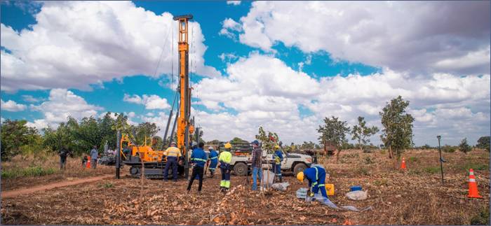
Figure 4: Core drilling (push tube) in action at Kasiya
AC drilling was completed by Thompson Drilling utilising a Smith Capital 10R3H compact track-mounted drill. The drilling is vertical and generates 1m samples with care taken in the top metres to ensure good recoveries of the high-grade surface material. The AC sample is collected by the on-board cyclone into heavy-duty RC sample bags. Drilling continues until bit refusal onto basement ~20-30m. Sample bags are immediately transported back to Sovereign's field laydown yard where they are processed. AC drilling is on a nominal 200m by 200m pattern.
The drilling programs to date show a surface mineralised extent, defined nominally by a 0.7% rutile cut-off, of approximately 268.6 km2 with numerous areas of high-grade rutile and graphite defined.
The PTDD and AC twin and density sample holes are selectively placed throughout the deposit to ensure a broad geographical and lithological coverage for the analysis.
MSA has reviewed Standard Operating Procedures (SOPs) for HA, SA, PTDD and AC drilling and found them to be fit for purpose and support the resource classifications as applied to the MRE.
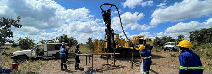
Figure 5: Air-core (AC) drilling at Kasiya in May 2022.
Sampling Techniques
HA samples are obtained at 1m intervals generating on average approximately 2.5kg of drill sample. HA samples are manually removed from the auger bit and sample recovery is visually assessed in the field. As samples become wet at the water table and recovery per metre declines, the drill hole is terminated. Each 1m sample is sun dried, logged and weighed. HA samples are composited based on regolith weathering boundaries defined by geology logging. Each 1m of sample is dried, lightly pressed to remove soft aggregates and riffle-split to generate a total sample weight of 3kg for analysis, generally at 2 - 5m intervals. This primary sample is then riffle split again to provide a 1.5kg sample each for rutile and graphite analyses.
SA samples are bulk spiral auger samples primarily designed to collect a large sample for metallurgical and pilot plant testwork. Bit sizes range from 300 mm to 700mm diameter. The samples are collected on 1m intervals, laid out on a large tarpaulin to be sun dried before using a cone and quarter method (for the 700mm diameter) to produce a roughly 100kg sample which is then riffle split to produce a 3kg sample, with the file split providing 1.5 kg each for rutile and graphite analysis. Samples are analysed in 1m intervals.
PTDD samples are predominantly from HQ sized core (61mm diameter). Half core 1m samples are sun dried, logged and weighed. Samples are then lightly pressed and composited over 2m intervals. An equal mass is taken from each contributing metre to generate a 1.5kg composite sample. Individual recoveries of core samples are recorded on a quantitative basis. Core recovery is very good overall at >95%.
AC samples are collected in 1m increments. AC samples are dried, riffle split, lightly pressed and composited. Samples are collected and homogenised prior to splitting to ensure sample representivity. ~1.5kg composite samples were defined by the regolith boundaries in earlier drilling. More recent AC drilling utilised regular 2m downhole composites. An equivalent mass is taken from each primary sample to make up the composite.
During 2024 twin drilling campaigns, samples were processed at 1m intervals to get a better understanding of drilling and deposit variability.
The sampling and compositing methods described are considered appropriate and reliable based on accepted industry practice. MSA completed an on-site audit of sampling and sample processing and deemed the processes fit for purpose.
Sample Analysis Methodology
All samples arrive at Sovereign's Malawi laboratory where they are sorted and checked in. Graphite samples are identified and prepared for export, while the equivalent rutile samples begin the sample workflow to generate the rutile non-magnetic concentrate (NM) for export for TiO2 and multi-element XRF analysis. Prior to June 2024 XRF analysis was completed at ALS Perth, Western Australia, currently Scientific Services South Africa (SS) laboratory in Cape Town, South Africa is being used. Umpire checks have shown good correlation between the two external laboratories. Audit of Sovereign's laboratory premises, staff, sample analysis and QA procedures was completed by MSA during two site visits in 2024 and 2025.
SVM Malawi Laboratory Rutile Workflow
· Samples are dried in a commercial oven for 1 hour at 105℃ and a dry raw samples mass is recorded.
· Samples are soaked in 1% Tetrasodium pyrophosphate (TSPP) solution overnight and then lightly agitated prior to wet screening.
· Wet screening occurs at 5mm, 600µm and 45µm to remove oversize and slimes (-45µm) material. Each +45µm retained fraction is dried, logged and weighed.
· The resulting sand fraction +45µm -600mm is oven dried for 1 hour at 105℃ after which its dry weight is recorded.
· The sand fraction is then passed over a Gemeni wet shaking table at a constant feed rate to generate a heavy mineral concentrate (HMC).
· Heavy Liquid Separation (HLS) at Diamantina Laboratories in Perth was initially trialled as a preferred separation method but was quickly superseded (supported by QA analysis) by wet-table separation on account of substantial near-density gangue material reporting to the HM sink for the HLS technique. The HLS analyses represent 6% of the MRE assay dataset.
· The wet-tabled HMC is then subject to magnetic separation @ 16,800G (2.9Amps), producing a magnetic (Mag) and non-magnetic (NMag) fraction. The separation is performed using a Mineral Technologies Reading Pilot IRM (Induced Roll Magnetic) purchased by Sovereign and located at the Company's laboratory in Malawi. Pre-2022, this step was completed by Allied Mineral Laboratories Perth (AML) in Perth, Western Australia.
The Malawi onsite laboratory sample preparation methods are considered quantitative to the point where the NMag concentrate (containing the rutile) is produced. Several generations of QEMSCAN analysis of the NMag and Mag fractions performed at ALS Metallurgy show dominantly clean and liberated rutile grains and confirm that rutile is the only titanium species in the NMag fraction.
Recovered rutile is defined and reported here as: TiO2 recovered in the SAND +45 to -600um range to the NMag concentrate fraction as a % of the total primary, dry, raw sample mass divided by 95% (to represent an approximation of final product specifications). i.e recoverable rutile within the whole sample.
Graphite Testwork
Once secured the 1.5kg graphite sample are delivered to Intertek Group plc (Intertek) in Johannesburg, South Africa, 750g of each 1.5kg graphite sample is pulverised to -75um with a 150g dissolved in dilute hydrochloric acid to liberate carbonate carbon. The solution is filtered using a filter paper, and the collected residue is then dried to 425°C in a muffle oven to drive off organic carbon.
The 150g dried sample is transported to Perth, Australia where it is then combusted in an Eltra CS-800 induction furnace infra-red CS analyser to yield total graphitic or elemental carbon (TGC).
QAQC
Accuracy monitoring is achieved through submission of certified reference materials (CRM's). Sovereign uses internal and externally sourced wet screening reference material inserted into samples batches at a rate of 1 in 20.
SS, ALS and Intertek both use internal CRMs and duplicates on XRF and TGC analyses. Sovereign also inserts its customised CRMs into all sample batches at a rate of 1 in 20.
Analysis of sample duplicates is undertaken by standard statistical methodologies (Scatter, Pair Difference and QQ Plots) to test for bias and to ensure that sample splitting is representative. Standards determine assay accuracy performance, monitored on control charts, where failure (beyond 2SD from the accepted mean value of the standard) initiates investigation and may trigger re-processing of the affected batch.
Examination of the QA/QC sample data indicates satisfactory performance of field sampling protocols and assay laboratories providing acceptable levels of precision and accuracy. Rutile determination by alternate methods showed no material bias.
Estimation Methodology
Datamine Studio RM, LeapFrog and Supervisor software are used for the data analysis, variography, geological interpretation and resource estimation.
A 3D block model honouring the geology boundaries which included weathering horizons; barren mafic intrusives; surface clay horizons and presence of barren or low grade amphibolite was created. The model was also coded with the tenement EL codes, rock in-situ dry bulk density and moisture content.
Rutile mineralisation was defined as the last intercept >=2m down hole exceeding 0.4% rutile. Generally, rutile grade is highest at the surface gradually reducing in grade with depth. Using this guideline very little internal low grade/waste is introduced. The resulting sample point data was used to create the bounding lower surface digital terrane model (DTM) for a rutile mineralisation, topography DTM is the upper surface. Additional manual points were interpreted section by section to ensure consistency especially in areas with wider spaced drilling.
Graphite mineralisation was defined as the highest up hole intercept >=2m exceeding 0.6% TGC. Generally TGC grade is highest at depth gradually reducing in grade closer to the surface. Using this guideline very little internal low grade/waste is introduced. A graphite mineralisation upper limit DTM was constructed following a similar process to that used for the Rutile DTM. The lower limit of graphite mineralisation was either the base of drilling or the top of SAPR if drilling intersected SAPR.
Eight grade domains were created, 4 mineralised and 4 low grade / waste for both rutile and graphite. The domains are derived from the combination of weathering type inside or outside the mineralisation DTM's. Samples were composited to 1 sample per drillhole per domain. Rutile and TGC samples were treated independently as there is no correlation between rutile and TGC grades.
The composite populations generally approximated normal distributions with some -ve and/or +ve skewness relating to the imposed mineralisation boundary.
Ordinary Kriging (OK) was considered the best grade estimator for both rutile and graphite due to the near normal grade populations and adequate variograms. Variography analysis was used to determine domain nugget effect and OK search and neighbourhood parameters.
Each grade domain was treated as a 2D seam and estimated using OK with dynamic anisotropy which followed the broad mineralisation continuity trends. No declustering or removal of twin data was required, as OK is an efficient declustering algorithm, and the post OK checks demonstrated no negative weights in the mineralised zones. Any areas not estimated were set to waste grades.
The parent cell size used is equivalent to the average drill hole spacing within the Indicated Resource (200m*200m). XY sub-celling to 50m*50m is adequate resolution for horizontal boundaries. Seam modelling ensured the mineralisation, weathering and topography layers were vertically accurate (within the 50m horizontal resolution). Grade was estimated using the parent cell panel size.
Grade estimation was constrained by hard boundaries (domains) that result from the geological interpretation and mineralisation interpretation.
Top Capping was applied to the composites considered to be outliers to reduce local high grade bias. Generally <1% of samples had a grade cap applied.
Validation of the grade estimate was completed both visually and statistically. Visual validation by loading the model and drill hole files and annotating, colouring and using filtering to check for the appropriateness of the estimate. Distributions of section line averages (swath plots) for drill holes and models were prepared for each zone and orientation for comparison purposes.
The resource model has appropriately averaged the informing drill hole data and is considered suitable to support the resource classifications applied to the estimate.
In-situ dry bulk density was calculated from 400 core samples taken from geographically and lithologically representative sites across the deposit. Dry bulk density is calculated from PT drill core using a cylinder volume wet and dry method performed by Sovereign in Malawi. Shelby tube core samples collected from the 2024 PTDD drill program were analysed by CIVILAB in South Africa.
Bulk density data was coded by weathering horizon. Population distributions were then reviewed and obvious outlies removed. Either the mean or median were used as the average for each weathering and/or rock type domain.
The average in-situ dry bulk density of the total MRE is 1.60 t/m3. This is derived from using an average density of 1.39 t/m3 for the SOIL; 1.58 t/m3 for the FERP, 1.66 t/m3 for the MOTT; 1.68 t/m3 for the PSAP; and 1.77 t/m3 for SAPL. (Definitions provided in Appendix 1 below).
Mining and Metallurgy Factors
Dry-mining has been determined as the optimal method of mining for the Kasiya Rutile deposit. The materials competence is loose, soft, fine and friable with no cemented sand or dense clay layers, allowing for a free dig mining method. It is considered that the strip ratio would be zero or near zero. Dilution is minimal as rutile mineralisation occurs from surface and mineralisation is generally gradational with few sharp boundaries.
Recovery parameters have not been factored into the estimate. However, the valuable minerals are readily separable due to their density differential and flotation characteristics and are expected to have high recoveries through the proposed conventional wet concentration plant for rutile and flotation for graphite, as demonstrated by metallurgical test work. Graphite losses occur predominantly in the desliming and wet gravity circuit, with flotation recoveries above 95% in variability testing.
Sovereign has announced three sets of metallurgical results to the market (24 June 2019, 9 September 2020 and 7 December 2021), relating to the Company's ability to produce a high-grade rutile product with a high recovery via simple conventional processing methods. Subsequent to this Sovereign has reported results related to metallurgical testwork within the following market announcements:
· "Kasiya Scoping Study Confirms Globally Significant Natural Rutile Project" dated 16 December 2021;
· "Kasiya Expanded Scoping Study Results" dated 16 June 2022; and
· "Kasiya Pre-Feasibility Study Results" dated 28 September 2023.
Sovereign engaged AML to conduct the metallurgical test work on the rutile circuit inclusive of the ongoing DFS to provide input for metallurgy and engineering process design. The work has consistently shown a premium quality rutile product of 95.0%+ TiO2 with low impurities could be produced with recoveries of up to 98% and with favourable product sizing.
Sovereign has also received third-party confirmations for the quality of its rutile product, including validation from one of Japan's premier titanium metal (sponge and ingot) producers, Toho Titanium Company Limited (Toho). Toho has confirmed the suitability of natural rutile from Kasiya for manufacturing high-specification titanium products.
Gravity separation was effective at concentrating graphite to a "light mineral pre-concentrate" due to its low specific gravity (~2.2 t/m³), providing an upgrade of graphite grade to the flotation circuit to about three times the run-of-mine grade.
The "light tailings" from processing the 45-600 micron ore to generate the rutile-enriched HMC is combined with "light tailings" from wet table gravity processing the 600 micron to 1mm size fraction of the ore to maximise coarse graphite recovery.
Graphite testwork programs were conducted at SGS Canada - Lakefield, ALS Limited, and Core Resources Pty Ltd in Australia at benchtop and pilot scales, including variability testwork, with pilot-scale programs supported by rougher flotation at Maelgwyn Mineral Services Africa (Pty) Ltd in South Africa to reduce shipment masses. A conventional graphite flotation and milling flowsheet was used, except for no milling prior to rougher flotation.
Classification
The Kasiya MRE has been classified as Measured, Indicated or Inferred.
JORC classification considered geological understanding; mineralisation continuity; drilling and sampling quality and spacing; OK estimation efficiency (KE) and confidence (SoR); with consideration of the proposed mining method and scale.
The dominant control on grade distribution within the mineralised zone is intensity of weathering. Rutile is a mineral resistant to weathering and is concentrated by depletion of less resistant minerals during the weathering process resulting in higher grades near the surface where more intense weathering has taken place. The weathering profiles are consistent and readily defined by logging of drill samples.
Both rutile and graphite mineralisation have been well defined by drilling with appropriate sample analysis to determine recovered rutile in-situ grade and in-situ TGC. Both mineralisation zones are broad and continuous with rutile dominant in the Soil, FERP and MOTT horizons, and graphite in the MOTT, PSAP and SAPL horizons. There is significant overlap of the two mineralisation zones. The mineralisation is truncated either by changes in the protolith or displaced by mafic intrusives. Recent drainage has also impacted mineralisation continuity. Minor near surface clay lenses and metamorphic 'pegmatitic' zones also displace mineralisation. These very minor internal 'waste' zones are readily visually identifiable during mining (as seen during the 2024 trial mining exercise) and can be selectively either mined or bypassed. The dominant zones of mineralisation exceed 10km of strike continuity and range from 1 to 4 km in width.
Regional exploration was completed on a nominal 800m square grid, with infill to 400m followed by either 200m square or 200m offset grid. Twin holes plus some close spaced geostatistical drilling, close spaced channel sampling during the trial mining and open pit sampling have all demonstrated the robustness of the geology interpretation and mineralisation continuity.
KE generally exceeds 0.6 with SoR exceeding 0.85 in the appropriately drilled mineralised zones.
On the basis of the high confidence geology interpretation; mineralisation scale and continuity including taking into account the bulk mining method; and very tight grade distributions within the estimation domains, the Competent Person is comfortable classifying all of the rutile and graphite mineralisation which lies above the base of drilling as either Measured, Indicated or Inferred.
Measured was defined using a nominal KE >=0.7 to 0.75 and a SOR >=0.9, which generally matches areas with a drill spacing closer than 200m. A boundary was used to define the Measured Mineral Resource. At Kingfisher south of 8,467,700N, infill drilling was only completed to the base of FERP (to support minimum 5 year mine plan), so Measured was assigned to Soil+FERP and Indicated to material below FERP.
Indicated was defined using a nominal KE >=0.4 to 0.5 and a SOR >=0.8, which generally matches areas with a nominal drill spacing of 200 to 400m. A boundary was used to define the Indicated Mineral Resource. All mineralisation outside the Indicated boundary was classed as Inferred Mineral Resource.
The parameters used to define Indicated classification are different from the previous MRE. The changes are primarily due to the improved grade modelling methodology, which is based on treating each mineralisation domain as a single 2D seam model. This method supports the bulk dry mining process and improves the grade confidence at wider drill spacings, as no selective mining is anticipated within each seam.
The MRE was constrained to a potentially economic open pit shells to reflect the JORC Code requirement for Reasonable Prospects for Eventual Economic Extraction (RPEEE). The shell was defined using Whittle Open Pit Optimisation with the following parameters:
Rutile: Net concentrate revenue US$1,400/t; Process recovery 97.6%;
Graphite: Net revenue US$1,200/t ; Process recovery 70.4%s;
Mining OPEX US$1.35/t; Process OPEX US$5.44/t.
The MRE is presented in three tables (see Tables 3-5).
Sensitivity options were run on graphite basket price from US$1,200/t to US$2,000/t - the MRE is not sensitive to graphite price.
Cuf-off grades
All results reported are of a length-weighted average of in-situ grades.
A nominal bottom cut of 0.7% rutile is used, based on preliminary assessment of resource product value and anticipated cost of operations.
MRE TABLES
Table 3: Kasiya March 2026 Model - Rutile Mineral Resource
Table 3 presents the rutile dominant mineral resource based on a higher rutile cut-off pit shell - optimised using the $1,400 rutile price using a mineralisation cutoff of 0.75% rutile. All material with a rutile grade >=0.4% (the nominal mining breakeven grade) within the pit shell was reported. This pit shell was generated to maximise high grade rutile as a direct comparison with the previously reported MRE. The pit shell includes a small proportion of internal waste <0.4% rutile which is shown in the tabulation.
|
Category |
Class |
Tonnes (Mt) |
Rutile Grade (%) |
Rutile (Mt) |
TGC (%) |
TGC (Mt) |
Rutile Eq. (%) |
|
Rutile Mineralisation >=0.4% Rut95 |
Measured |
107 |
1.05 |
1.12 |
1.56 |
1.67 |
1.94 |
|
Indicated |
1,545 |
0.97 |
14.99 |
1.05 |
16.26 |
1.57 |
|
|
Inferred |
452 |
0.91 |
4.12 |
0.45 |
2.02 |
1.17 |
|
|
Total Rutile MRE |
2,105 |
0.96 |
20.24 |
0.95 |
19.95 |
1.51 |
|
|
Internal Waste |
Measured |
1 |
0.24 |
0 |
1.88 |
0.02 |
1.32 |
|
Indicated |
40 |
0.25 |
0.10 |
1.92 |
0.77 |
1.35 |
|
|
Inferred |
7 |
0.22 |
0.02 |
1.69 |
0.12 |
1.19 |
|
|
Total internal waste in RPEEE |
48 |
0.24 |
0.12 |
1.88 |
0.91 |
1.32 |
|
|
Total Rutile in Pit Shell |
2,153 |
0.95 |
20.35 |
0.97 |
20.86 |
1.50 |
|
Note: Rutile Mineral Resource defined from an optimised pit shell with mineralisation defined as >= 0.75% Rut95. A rutile concentrate net price of US$1,400 was used to determine economic value. Graphite had no value for this run.
Table 4: Kasiya March 2026 Model - Graphite Mineral Resource
Table 4 presents the remaining mineral resource within the primary pit shell but outside (mainly below) the rutile-dominant pit shell. This table is further subdivided to show the high-grade graphite material >=0.6% TGC (primarily at depth) and the lower-grade rutile material (primarily at the edges of the deposit). The 0.6% TGC cut-off was selected as the statistically 'natural' value separating higher grade from lower grade.
|
Category |
Class |
Tonnes (Mt) |
TGC (%) |
TGC (Mt) |
Rutile Grade (%) |
Rutile (Mt) |
Rutile Eq. (%) |
Dry BD |
|
TGC>=0.6% |
Measured |
30 |
1.99 |
0.59 |
0.52 |
0.15 |
1.67 |
1.74 |
|
Indicated |
629 |
1.86 |
11.69 |
0.4 |
2.53 |
1.47 |
1.69 |
|
|
Inferred |
201 |
1.7 |
3.42 |
0.3 |
0.61 |
1.28 |
1.7 |
|
|
Subtotal HG |
860 |
1.83 |
15.7 |
0.38 |
3.29 |
1.43 |
1.69 |
|
|
TGC<0.6% |
Measured |
0.6 |
0.23 |
0 |
0.68 |
0 |
0.81 |
1.66 |
|
Indicated |
195 |
0.23 |
0.45 |
0.65 |
1.27 |
0.78 |
1.6 |
|
|
Inferred |
220 |
0.15 |
0.33 |
0.65 |
1.42 |
0.73 |
1.57 |
|
|
Subtotal MG |
415 |
0.19 |
0.78 |
0.65 |
2.69 |
0.76 |
1.59 |
|
|
Total Graphite MRE |
1,275 |
1.29 |
16.48 |
0.47 |
5.98 |
1.21 |
1.66 |
|
Note: Graphite Mineral Resource is all material inside the total MRE pit shell after depletion of the Rutile Mineral Resource.
Table 5: Kasiya Combined Rutile-Graphite Mineral Resource Estimate within the RPEEE pit shell (March 2026)
Table 5 presents the entire MRE constrained to the combined rutile and TGC RPEEE Open Pit shell. No cutoff is applied.
|
Class |
Tonnes (Mt) |
Rutile Grade (%) |
Rutile (Mt) |
TGC (%) |
TGC (Mt) |
Rutile Eq. (%) |
Dry BD |
|
Measured |
139 |
0.93 |
1.3 |
1.65 |
2.3 |
1.87 |
1.67 |
|
Indicated |
2,409 |
0.78 |
18.9 |
1.21 |
29.2 |
1.48 |
1.62 |
|
Inferred |
881 |
0.70 |
6.2 |
0.67 |
5.9 |
1.08 |
1.59 |
|
Total |
3,428 |
0.77 |
26.3 |
1.09 |
37.3 |
1.39 |
1.62 |
Note: The Total MRE includes all rutile and graphite mineralisation within an optimised open pit shell using a 95%+TiO2 rutile (Rut95) concentrate revenue price of net US$1,400/t and a Graphite product price of net US$1,200/t; Mine OPEX US$1.35/t; Process OPEX US$5.44/t; Rutile recovery of 97.6%; Average Graphite recovery of 70.4%. Figures are rounded and may not sum exactly.
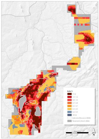
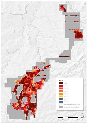
Figures 6 & 7: Kasiya March 2026 Model - Rutile (Rut94) Mineral Resource and Kasiya March 2026 Model - Graphite Mineral Resource
|
Enquiries |
|
Frank Eagar, Managing Director & CEO South Africa / Malawi +27 21 140 3190 Sapan Ghai, CCO London +44 207 478 3900 |
|
Nominated Adviser on AIM and Joint Broker |
|
|
SP Angel Corporate Finance LLP |
+44 20 3470 0470 |
|
Ewan Leggat Charlie Bouverat |
|
|
|
|
|
Joint Broker |
|
|
Stifel |
+44 20 7710 7600 |
|
Varun Talwar |
|
|
Ashton Clanfield |
|
Forward Looking Statement
This release may include forward-looking statements, which may be identified by words such as "expects", "anticipates", "believes", "projects", "plans", and similar expressions. These forward-looking statements are based on Sovereign's expectations and beliefs concerning future events. Forward looking statements are necessarily subject to risks, uncertainties and other factors, many of which are outside the control of Sovereign, which could cause actual results to differ materially from such statements. There can be no assurance that forward-looking statements will prove to be correct. Sovereign makes no undertaking to subsequently update or revise the forward-looking statements made in this release, to reflect the circumstances or events after the date of that release.
Competent Persons Statement
The information in this announcement that relates to the Mineral Resources Estimate is based on, and fairly represents, information compiled by Mr Jeremy Witley, a Competent Person, who is a member of the South African Council for Natural Scientific Professions (SACNASP Pr. Sci. Nat.), a Recognised Professional Organisation' included in a list promulgated by ASX from time to time. Mr Witley is a principal of MSA Group, an independent consulting company. Mr Witley has sufficient experience, which is relevant to the style of mineralisation and type of deposit under consideration, and to the activity he is undertaking, to qualify as a Competent Person as defined in the 2012 Edition of the 'Australasian Code for Reporting of Exploration Results, Mineral Resources and Ore Reserves' (and as a Qualified Person under the AIM Rules). Mr Witley consents to the inclusion of the matters based on his information in the form and context in which it appears.
The information in this announcement that relates to Exploration Results is based on, and fairly represents, information compiled by Mr Malcolm Titley, a Competent Person who is a member of The Australasian Institute of Mining and Metallurgy and member of Australian Institute of Geoscientists. Mr Titley is the Technical Services Manager of Sovereign and is a holder of unlisted performance rights in Sovereign. Mr Titley has sufficient experience that is relevant to the style of mineralisation and type of deposit under consideration and to the activity being undertaken, to qualify as a Competent Person as defined in the 2012 Edition of the 'Australasian Code for Reporting of Exploration Results, Mineral Resources and Ore Reserves' (and as a Qualified Person under the AIM Rules). Mr Titley consents to the inclusion in the report of the matters based on his information in the form and context in which it appears.
The information in this announcement that relates to Production Targets, Processing, Infrastructure and Capital and Operating Costs is extracted from an announcement dated 22 January 2025, which is available to view at www.sovereignmetals.com.au. Sovereign confirms that: a) it is not aware of any new information or data that materially affects the information included in the original announcement; b) all material assumptions and technical parameters underpinning the Production Target, and related forecast financial information derived from the Production Target included in the original announcement continue to apply and have not materially changed; and c) the form and context in which the relevant Competent Persons' findings are presented in this presentation have not been materially modified from the original announcement.
The information contained within this announcement is deemed by the Company to constitute inside information as stipulated under the Market Abuse Regulations (EU) No. 596/2014 as it forms part of UK domestic law by virtue of the European Union (Withdrawal) Act 2018 ('MAR'). Upon the publication of this announcement via Regulatory Information Service ('RIS'), this inside information is now considered to be in the public domain.
To view this announcement in full, including all images, tables and figures, please refer to https://api.investi.com.au/api/announcements/svm/1e1ba7f3-168.pdf.
Glossary
|
Abbreviation |
Description |
|
°C |
Degrees Celsius |
|
µm |
Micrometre or Micron |
|
AACE |
American Association of Cost Engineering |
|
AC |
Air-core |
|
ALS |
ALS Metallurgical Laboratory |
|
AML |
Allied Mineral Laboratories Perth |
|
amsl |
Above Mean Sea Level |
|
ARD |
Acid Rock Drainage |
|
AS |
Australian Standard |
|
ASNZS |
Australian and New Zealand Standard |
|
ASX |
Australian Stock Exchange |
|
AUD |
Australian Dollar |
|
ave |
Average |
|
BCM |
Bulk Cubic Meter |
|
BOO |
Build Own Operate |
|
Capex |
Capital Expenditure |
|
CFR |
Cost and Freight |
|
CEAR |
Central East African Railways |
|
cm |
Centimetre |
|
CPR |
Competent Persons Report |
|
CRM |
Certified Reference Material |
|
CSR |
Corporate Social Responsibility |
|
d |
Day |
|
D |
Discharge |
|
d/y |
Days Per Year |
|
DAP |
Delivered at Place |
|
dB |
Decibel |
|
DD |
Diamond-core Drilling |
|
DFS |
Definitive Feasibility Study |
|
DL |
Detection Limit |
|
dmt |
Dry Metric Tonne |
|
DRA |
DRA Limited |
|
DTM |
Digital Terrane Model |
|
EAD |
Environmental Affairs Department (of Malawi) |
|
EAP |
Employee Assistance Program |
|
EBITDA |
Earnings Before Interest, Taxes, Depreciation And Amortisation |
|
EHS |
Environment, Health, And Safety |
|
EIA |
Environmental Impact Assessment |
|
EL |
Exploration Licence |
|
EMP |
Environmental Management Plan |
|
EPC |
Engineering, Procurement, Construction |
|
EPCM |
Engineering, Procurement & Construction Management |
|
ERP |
Emergency Response Plan |
|
ESIA |
Environmental And Social Impact Assessment |
|
ESR |
Environmental Scoping Report |
|
FEED |
Front End Engineering And Design |
|
FEL |
Front End Loader |
|
FOB |
Free on Board |
|
FS |
Feasibility Study |
|
G&A |
General & Administration |
|
GEL |
Generally Expected Levels |
|
GHG |
Greenhouse Gas(es) |
|
GISTM |
Global Industry Standards on Tailings Management |
|
h |
Hour |
|
h/d |
Hours Per Day |
|
h/y |
Hours Per Year |
|
HA |
Hand-auger |
|
ha |
Hectare |
|
HLS |
Heavy Liquid Separation |
|
HMC |
Heavy Mineral Concentrate |
|
HR |
Human Resources |
|
HRMP |
Human Resources Management Plan |
|
HSE |
Health, Safety and Environment |
|
HSEMS |
Health Safety and Environmental Management System |
|
HSMP |
Health and Safety Management Plan |
|
HV |
High Voltage |
|
IBC |
Intermediate Bulk Container |
|
ICP-MS |
Inductively Coupled Plasma Mass Spectrometer |
|
ICP-OES |
Inductively Coupled Plasma Optical Emission Spectrometry |
|
ID |
Internal Diameter |
|
IDW |
Inverse-Distance Weighted Algorithm |
|
IFC |
International Finance Corporation |
|
IRR |
Internal Rate of Return |
|
IT |
Information Technology |
|
IUCN |
International Union for Conservation of Nature |
|
IVI |
Important Value Index |
|
J |
Joule (Energy) |
|
JECFA |
Joint FAO/WHO Expert Committee on Food Additive |
|
JHA |
Job Hazard Analysis |
|
JORC |
Australasian Joint Ore Reserves Committee |
|
k |
Kilo or Thousand |
|
kg |
Kilogram |
|
km |
Kilometre |
|
KPI |
Key Performance Indicator |
|
KRW |
Korean Won |
|
kt |
Kilo Tonne (Thousand Metric Tonne) |
|
kW |
Kilowatt (Power) |
|
kWh |
Kilowatt Hour |
|
L |
Litre |
|
LCT |
Locked Cycle Testwork |
|
LME |
London Metals Exchange |
|
LoM |
Life of Mine |
|
LSE |
London Stock Exchange |
|
LTI |
Lost Time Injury |
|
LV |
Low Voltage |
|
m |
Metre |
|
M |
Million |
|
m2 |
Square Metre |
|
m3 |
Cubic Metre |
|
Ma |
Mega annum (million years) |
|
MAG |
Magnetic |
|
MCC |
Motor Control Centre |
|
MG |
Mine Gate |
|
ML |
Metal Leaching |
|
mm |
Millimetre |
|
MNREM |
Ministry of Natural Resources, Energy and Mining |
|
MPA |
Maximum Potential Acidity |
|
MPN |
Most Probably Number (Count of Coliforms and E. coli) |
|
MRA |
Malawi Revenue Authority |
|
MRE |
Mineral Resource Estimate |
|
mRL |
Metre Reduced Level |
|
MRMR |
Mining Rock Mass Rating |
|
Msal |
Meters Above Sea Level |
|
MSDS |
Material Safety Data Sheet |
|
Mt |
Million Tonnes (Metric) |
|
Mt/y |
Million Tonnes Per Year |
|
MTI |
Medical Treatment Injury |
|
MTO |
Material Take-Off |
|
MW |
Megawatt |
|
N/A |
Not Applicable |
|
NA |
Not Available |
|
NAF |
Non-Acid Forming |
|
NAG |
Net Acid Generation |
|
NAPP |
Net Acid Producing Potential |
|
ND |
Not Detected |
|
NMAG |
Non-Magnetic |
|
NOH&SC |
National Occupational Health and Safety Commission (Australia) |
|
NPI |
Non Process Infrastructure |
|
NPV |
Net Present Value |
|
NR |
Not Regulated |
|
NT |
Near Threatened |
|
NTU |
Normalised Turbidity Unit |
|
OHS&E |
Occupational Health, Safety & Environment |
|
OK |
Ordinary Kriging |
|
PEA |
Preliminary Economic Assessment |
|
PFD |
Process Flow Diagram |
|
PFS |
Pre-Feasibility Study |
|
PPE |
Personal Protective Equipment |
|
PS |
Performance Standard |
|
PSU |
Practical Salinity Unit |
|
PTDD |
Push-tube and/or diamond core |
|
PWTP |
Potable Water Treatment Plant |
|
QA/QC |
Quality Assurance And Quality Control |
|
RAP |
Resettlement Action Plan |
|
ROM |
Run-Of-Mine |
|
RPEEE |
Reasonable Prospects for Eventual Economic Extraction |
|
RRT |
Resource Rent Tax |
|
s |
Second |
|
SG |
Specific Gravity |
|
SGS |
SGS Metallurgical Laboratory |
|
SO2 |
Sulphur Dioxide |
|
SOP |
Standard Operating Procedure |
|
ST |
Total Sulphur |
|
SVM |
Sovereign Metals Limited |
|
t |
Tonne (Metric) |
|
t/h |
Tonnes Per Hour |
|
t/m3 |
Tonnes Per Cubic Metre |
|
t/y |
Tonnes Per Year |
|
ta |
Comminution Test Parameter |
|
TARP |
Trigger, Action, Responsibility, Procedure |
|
TBC |
To Be Confirmed |
|
TC |
Total Carbon |
|
TC |
Treatment Charge |
|
TDS |
Total Dissolved Solids |
|
TGC |
Total Graphitic Carbon |
|
TSF |
Tailings Storage Facility |
|
TSP |
Total Suspended Particulates |
|
TSPP |
Tetrasodium Pyrophosphate |
|
TSS |
Total Suspended Solids |
|
TZMI |
TZ Minerals International Pty Ltd |
|
UFD |
Utility Flow Diagram |
|
UOM |
Unit of Measure |
|
URTI |
Upper Respiratory Tract Infection |
|
US EPA |
The United States Environmental Protection Agency |
|
US$ |
United States Dollar |
|
USD |
United States Dollar |
|
UTM |
Universal Transverse Mercator |
|
V |
Volt |
|
VAT |
Value Added Tax |
|
VSD |
Variable Speed Drive |
|
VTEM |
Versatile Time Domain Electromagnetic |
|
VU |
Vulnerable |
|
w/v |
Weight/Volume |
|
w/w |
Weight/Weight |
|
WBG |
World Bank Group |
|
WBS |
Work Breakdown Schedule |
|
WHO |
World Health Organization |
|
XRD |
X-Ray Diffraction |
|
XRF |
X-Ray Fluorescence |
APPENDIX 1: JORC CODE, 2012 EDITION - TABLE 1
Section 1 - Sampling Techniques and Data
|
Criteria |
JORC Code explanation |
Commentary |
|||||||||||||||||||||||||||||||||||||||||||||||||||||||||||||||||||||||||||
|
Sampling Techniques |
Nature and quality of sampling (e.g. cut channels, random chips, or specific specialised industry standard measurement tools appropriate to the minerals under investigation, such as down hole gamma sondes, or handheld XRF instruments, etc). These examples should not be taken as limiting the broad meaning of sampling. |
Hand Auger (HA) samples are composited based on regolith boundaries and sample chemistry generated by hand-held XRF (pXRF). Each 1m of sample is dried and riffle-split to generate a total sample weight of 3kg for analysis, generally at 2 - 5m intervals. Spiral Auger (SA) samples are mechanical auger bulk samples collected at 1m intervals. Each 1m of sample is dried and riffle-split to generate a total sample weight of 3kg for analysis. Push-Tube and/or Diamond Core (PTDD) core drilling is sampled routinely at 2m intervals by compositing dried and riffle-split half core. Several PTDD holes were sampled on 1m intervals in a twinning campaign with HA and AC. Air-Core (AC) samples are generally composited on 2m intervals. Each 1m of sample is dried and riffle-split to generate a total sample weight of 3kg for analysis. For all sampling methods the primary sample (nominally 3kg) is split to provide two 1.5kg samples for both rutile and graphite analyses. |
|||||||||||||||||||||||||||||||||||||||||||||||||||||||||||||||||||||||||||
|
|
Include reference to measures taken to ensure sample representivity and the appropriate calibration of any measurement tools or systems used. |
Drilling and sampling activities are supervised by a suitably qualified company geologist who is present at all times. All drill samples are geologically logged by the geologist at the drill site/core yard. Each sample is sun dried and homogenised. Sub-samples are carefully riffle split to ensure representivity. The 1.5kg composite samples are then processed. An equivalent mass is taken from each sample to make up the composite. A calibration schedule is in place for laboratory scales, sieves and field XRF equipment. Prior to June 2024 Placer Consulting Pty Ltd (Placer), then post June2024 MSA Group Resource Geologists completed site visits and reviewed Standard Operating Procedures (SOPs) for the collection and processing of drill samples and found them to be fit for purpose and support the resource classifications as applied to the MRE. The primary composite sample is considered representative for this style of rutile and graphite mineralisation. |
|||||||||||||||||||||||||||||||||||||||||||||||||||||||||||||||||||||||||||
|
|
Aspects of the determination of mineralisation that are Material to the Public Report. In cases where 'industry standard' work has been done this would be relatively simple (e.g. 'reverse circulation drilling was used to obtain 1 m samples from which 3 kg was pulverised to produce a 30 g charge for fire assay'). In other cases more explanation may be required, such as where there is coarse gold that has inherent sampling problems. Unusual commodities or mineralisation types (e.g. submarine nodules) may warrant disclosure of detailed information. |
Logged mineralogy percentages, lithology/regolith information and TiO2% obtained from pXRF are used to assist in determining compositing intervals. Care is taken to ensure that only samples with similar geological characteristics are composited together. |
|||||||||||||||||||||||||||||||||||||||||||||||||||||||||||||||||||||||||||
|
Drilling Techniques |
Drill type (e.g. core, reverse circulation, open‐hole hammer, rotary air blast, auger, Bangka, sonic, etc) and details (e.g. core diameter, triple or standard tube, depth of diamond tails, face‐sampling bit or other type, whether core is oriented and if so, by what method, etc). |
Several sampling methods have been tested at Kasiya. The drill types deemed suitable for use in the MRE are Hand Auger (HA 62mm), Air Core (AC 75 and 115mm), Push Tube and/or Diamond Core (PTDD 61 and 88mm) and Spiral Mechanical Auger (SA 300 and 700mm). Other sampling methods used for geological and verification purposes included open pit bulk samples (PIT 1x1m), Channel samples (CH 62 and 100mm) from bulk sample pits, the trial mining open pit and rehabilitation trial pits. All sampling was carried out vertically to best intersect the horizontal weathering and grade layers. All material of interest is in the weathered zones located above the saprock boundary, so no collection of oriented core was possible or warrented. |
|||||||||||||||||||||||||||||||||||||||||||||||||||||||||||||||||||||||||||
|
|
|
Two similar designs of HA drilling equipment are employed. HA drilling with 75mm diameter enclosed spiral bits (SOS) with 1m long steel rods and with 62mm diameter open spiral bits (SP) with 1m long steel rods. The SP bit accounts for less than 10% of the HA drilling, as the enclosed spiral proved to be the more effective tool. Drilling is oriented vertically by eye. Each 1m of drill sample is collected into separate sample bags and set aside. The auger bits and flights are cleaned between each metre of sampling to avoid contamination. Core-drilling is undertaken using a drop hammer, Dando Terrier MK1. The drilling generated 1m runs of 88mm PQ core in the first 2m and then transitioned to 61mm core for the remainder of the hole. Core drilling is oriented vertically by spirit level. AC drilling was completed by Thompson Drilling utilising a Smith Capital 10R3H compact track-mounted drill. Each 1m sample bag is immediately transported back to Sovereign's secure field laydown yard for processing. |
|||||||||||||||||||||||||||||||||||||||||||||||||||||||||||||||||||||||||||
|
Drill Sample Recovery |
Method of recording and assessing core and chip sample recoveries and results assessed. |
Samples are assessed visually for recoveries. The configuration of drilling and nature of materials encountered results in negligible sample loss or contamination. HA and PT drilling is ceased when recoveries become poor once the water table has been reached. Water table and recovery information is included in lithological logs. Core drilling samples are actively assessed by the driller and geologist onsite for recoveries and contamination. AC drilling recovery in the top few metres is moderate to good. Extra care is taken to maximise sample recovery in these metres. Sample weight is recorded to determine recovery at the rig at the time of drilling by the geologist. Drilling is ceased when recoveries become poor or once Saprock or refusal has been reached. The use of the AC 115mm has been adopted as the standard since October 2025. Improvements in both air pressure and cyclone management have resulted in excellent recovery. This has been combined with the use of SA 300mm twin drilling to the base of the FERP layer (4 to 6m) to further validate the quality of the AC 115mm drilling. |
|||||||||||||||||||||||||||||||||||||||||||||||||||||||||||||||||||||||||||
|
|
Measures taken to maximise sample recovery and ensure representative nature of the samples. |
The Company's trained geologists supervise drilling on a 1 team 1 geologist basis and are responsible for monitoring all aspects of the drilling and sampling process. For PT drilling, core is extruded into core trays; slough is actively removed by the driller at the drilling rig and core recovery and quality is recorded by the geologist. AC samples are recovered in large plastic bags. The bags are clearly labelled and delivered back to sovereign's laydown yard at the end of shift for processing. Since October 2025 the cyclone is checked every 1m. If there is any hang-up in the cyclone, this material is collected and recombined with the primary sample. |
|||||||||||||||||||||||||||||||||||||||||||||||||||||||||||||||||||||||||||
|
|
Whether a relationship exists between sample recovery and grade and whether sample bias may have occurred due to preferential loss/gain of fine/coarse material. |
No relationship is believed to exist between grade and sample recovery. The high percentage of silt and absence of hydraulic inflow from groundwater at this deposit results in a sample size that is well within the expected size range. An oversize (>5mm) bias can occur where larger coarse fragments, predominantly near the surface, appear preferentially recovered when using different diameter drilling methods. The use of larger diameter drilling (AC 115mm and SA 300mm) negates the potential for this bias. |
|||||||||||||||||||||||||||||||||||||||||||||||||||||||||||||||||||||||||||
|
Logging |
Whether core and chip samples have been geologically and geotechnically logged to a level of detail to support appropriate Mineral Resource estimation mining studies and metallurgical studies. |
Geological data is collected in adequate detail for use in Mineral Resource estimation. All individual 1m HA intervals are geologically logged, recording relevant data using company codes. A small representative sample is collected for each 1m interval and placed in chip trays for future reference. All individual 1m PT core intervals are geologically logged, recording relevant data using company codes. Half core remains in the trays and is securely stored in the company warehouse. AC and SA 1m intervals are geologically logged using company codes. A small representative sample is collected for each 1m interval and placed in chip trays for future reference. |
|||||||||||||||||||||||||||||||||||||||||||||||||||||||||||||||||||||||||||
|
|
Whether logging is qualitative or quantitative in nature. Core (or costean, channel, etc.) photography. |
All logging includes lithological features and estimates of basic mineralogy. Logging is qualitative. The PTDD core is photographed dry. |
|||||||||||||||||||||||||||||||||||||||||||||||||||||||||||||||||||||||||||
|
|
The total length and percentage of the relevant intersection logged |
100% of samples are geologically logged. |
|||||||||||||||||||||||||||||||||||||||||||||||||||||||||||||||||||||||||||
|
Sub- sampling techniques and sample preparation |
If core, whether cut or sawn and whether quarter, half or all core taken. |
Due to the soft weathered nature of the material, core samples are carefully cut in half using hand tools. |
|||||||||||||||||||||||||||||||||||||||||||||||||||||||||||||||||||||||||||
|
|
If non-core, whether riffled, tube sampled, rotary split, etc. and whether sampled wet or dry. |
HA, PTDD, SA and AC hole samples are dried, riffle split and composited. Samples are collected and homogenised prior to splitting to ensure sample representivity. ~1.5kg composite samples are processed. Where drillhole lengths are composited into longer samples for processing, an equivalent mass is taken from each primary sample to make up the composite. The primary composite sample is considered representative for this style of mineralisation and is consistent with industry standard practice. |
|||||||||||||||||||||||||||||||||||||||||||||||||||||||||||||||||||||||||||
|
|
For all sample types, the nature, quality and appropriateness of the sample preparation technique. |
Techniques for sample preparation are detailed on SOP documents verified by Placer and MSA Resource Geologists. Sample preparation is recorded on a standard flow sheet and detailed QA/QC is undertaken on all samples. Sample preparation techniques and QA/QC protocols are appropriate for mineral determination and support the resource classifications as stated. |
|||||||||||||||||||||||||||||||||||||||||||||||||||||||||||||||||||||||||||
|
|
Quality control procedures adopted for all sub-sampling stages to maximise representivity of samples. |
The sampling equipment is cleaned after each sub-sample is taken. Field duplicate, laboratory replicate and standard sample statistical analysis is employed to manage sample precision and analysis accuracy. |
|||||||||||||||||||||||||||||||||||||||||||||||||||||||||||||||||||||||||||
|
|
Measures taken to ensure that the sampling is representative of the in situ material collected, including for instance results for field duplicate/second-half sampling. |
Sample size analysis is completed to verify sampling accuracy. Field duplicates are collected for precision analysis of riffle splitting. SOPs consider sample representivity. Results indicate a sufficient level of precision for mineral resource classification. |
|||||||||||||||||||||||||||||||||||||||||||||||||||||||||||||||||||||||||||
|
|
Whether sample sizes are appropriate to the grain size of the material being sampled. |
The sample size is considered appropriate for the material sampled. |
|||||||||||||||||||||||||||||||||||||||||||||||||||||||||||||||||||||||||||
|
Quality of assay data and laboratory tests |
The nature, quality and appropriateness of the assaying and laboratory procedures used and whether the technique is considered partial or total. |
Rutile All sample preparation is completed at Sovereign Metals Malawi onsite laboratory (SSL) located in Lilongwe. The sample preparation methods are considered quantitative to the point where a non-magnetic (NMag) concentrate is generated.. Since June 2023 SSL has included the magnetic separation process to create the NMag concentrate, which is then sent to an external laboratory for TiO2 analysis. Prior to 2023 the Heavy Mineral Concentrate (HMC) was sent to AML Laboratory in Perth for separation. Final results generated are for recovered rutile i.e, the % mass of the sample that is rutile that can be recovered to the non-magnetic component of a HMC. The current SSL Laboratory workflow is: · Dry sample in oven for 1 hour at 105℃ · Soak in water with 1% Tetrasodium pyrophosphate (TSPP) for 12 hours and lightly agitate · Wet screen at 5mm, 600µm and 45µm to remove oversize and slimes material, since October 2025 a 2mm to 5mm size fraction has also been screened to represent the +2mm portion produced from the planned processing plant. |
|||||||||||||||||||||||||||||||||||||||||||||||||||||||||||||||||||||||||||
|
|
|
· Dry +45µm -600mm (sand fraction) in oven for 1 hour at 105℃ · Pass +45µm -600mm (sand fraction) across wet table to generate a HMC. · Dry HMC in oven for 30 minutes at 105℃ · Magnetic separation of the HMC by Carpco magnet @ 16,800G (2.9Amps) into a magnetic (Mag) and non-magnetic (NMag) fraction · Send NM to external laboratory for TiO2% (and other elements) XRF analysis Various workflows were use to produce HMC, Magnetic separation and external laboratory TiO2% plus other XRF analysis prior to June 2023 Work flow codes and number of samples impacted are presented below:
DIA-AML-IT and DIA-AML-ALS · The Sand fractions are sent to Diamantina Laboratories, Perth. Split ~150g of sand fraction for HLS using Tetrabromoethane (TBE, SG 2.96g/cc) as the liquid heavy media to generate HMC. (Heavy liquid separation (HLS) of the HM is no longer required and a HM result is not reported in the updated MRE. The HMC prepared via wet-table, gravity separation at the Lilongwe Laboratory provides an ideal sample for subsequent magnetic separation and XRF.) · Bag the HMC fraction and send to AML Perth for quantitative separation. · The resulting NM fractions are sent to either ALS Metallurgy Perth or Intertek Perth for quantitative XRF analysis. LLW-AML-IT and LLW-AML-ALS · Bag HMC fraction and send to Perth, Australia for quantitative separation at AML · The resulting NM fractions are sent to either ALS Metallurgy Perth or Intertek Perth for quantitative XRF analysis. LLW-LLW-ALS · The NM fractions are sent to ALS Metallurgy Perth for quantitative XRF analysis. Samples receive XRF_MS and are analysed for: TiO2, Al2O3, CaO, Cr2O3, Fe2O3, K2O, MgO, MnO, SiO2, V2O5, ZrO2, HfO2. LLW-LLW-SS · The NM fractions are sent to Scientific Servies South Africa for quantitative XRF analysis. Samples are analysed for: TiO2, Nd2O3, CeO2, La2O3, BaO, HfO2, Nb2O5, ZrO2, Y2O3, Fe2O3, MnO, Cr2O3, V2O5, CaO, K2O, P2O5, SiO2, Al2O3, MgO, NaO2 The number of Rutile samples used in the MRE by hole type are:
Graphite All graphite samples were processed at Intertek-Genalysis Johannesburg and Perth via method C72/CSA. 750g of each 1.5kg graphite sample is pulverised to -75um with a 150g sub-sample dissolved in dilute hydrochloric acid to liberate carbonate carbon. The solution is filtered using a filter paper and the collected residue is the dried to 425°C in a muffle oven to drive off organic carbon. The 150g dried sample is then combusted using an Eltra CS-800 induction furnace infra-red Carbon / Sulphur analyser er to yield total graphitic or TGC as a percentage of the total rock. The number of samples analysed for TGC and used in the MRE by hole type are:
In some holes (especially near the surface) no graphite float was detected, these samples were not sent for analysis and were set to waste TGC grades:
|
|||||||||||||||||||||||||||||||||||||||||||||||||||||||||||||||||||||||||||
|
|
For geophysical tools, spectrometers, handheld XRF instruments, etc., the parameters used in determining the analysis including instrument make and model, reading times, calibrations factors applied and their derivation, etc. |
Acceptable levels of accuracy and precision have been established. No pXRF methods are used for quantitative determination. |
|||||||||||||||||||||||||||||||||||||||||||||||||||||||||||||||||||||||||||
|
|
Nature of quality control procedures adopted (e.g. standards, blanks, duplicate, external laboratory checks) and whether acceptable levels of accuracy (i.e. lack of bias) and precision have been established. |
Sovereign uses internal and externally sourced wet screening reference material inserted into samples batches at a rate of 1 in 20. The externally sourced, certified standard reference material for HM and Slimes assessment is provided by Placer Consulting. |
|||||||||||||||||||||||||||||||||||||||||||||||||||||||||||||||||||||||||||
|
|
|
Accuracy monitoring of the analytical work is achieved through submission of certified reference materials (CRM's). ALS, Scientific Services and Intertek all use internal CRMs and duplicates on XRF analyses. Sovereign also inserts CRMs into the sample batches at a rate of 1 in 20. Three Rutile CRMs are used by Sovereign and range from 35% - 95% TiO2. Three Graphite CRMs are used by Sovereign and range from 3% - 25% TGC. Analysis of sample duplicates is undertaken by standard statistical methodologies (Scatter, Pair Difference and QQ Plots) to test for bias and to ensure that sample splitting is representative. Standards determine assay accuracy performance, monitored on control charts, where failure (beyond 3SD from the mean) may trigger re-assay of the affected batch. Examination of the QA/QC sample data indicates satisfactory performance of field sampling protocols and assay laboratories providing acceptable levels of precision and accuracy. Acceptable levels of accuracy and precision are displayed in statistical analyses to support the resource classifications as applied to the estimate. |
|||||||||||||||||||||||||||||||||||||||||||||||||||||||||||||||||||||||||||
|
Verification of sampling & assaying |
The verification of significant intersections by either independent or alternative company personnel. |
Results are reviewed in cross-section using Datamine Studio RM and either Micromine or LeapFrog software and any spurious results are investigated. Extreme high grades are not encountered for either rutile or graphite. |
|||||||||||||||||||||||||||||||||||||||||||||||||||||||||||||||||||||||||||
|
|
The use of twinned holes. |
Twinned holes are drilled across a geographically dispersed area to determine short-range geological and assay field variability for the resource estimation. Twins were primarily: HA and AC; PTDD and AC and more recently SA and AC. A total of 389 twin holes have been drilled of which 135 are twins of the same drilling type, the remainder being comparisons between different drilling methods. All twins are within 5m of each other. The October/November AC 115mm drilling program included SA 300mm twins to the base of the FERP layer, a total of 55 twin holes. The comparison showed a 2.5% lower Rut95 grade in the AC, with the difference primarily in the higher grade near surface material. This difference was not unexpected due to difference in sample diameter. The results demonstrate the improved quality of AC recovery using the 115mm drill bit. Comparison between the drilling methods shows some bias in the sizing distributions particularly in the volume of +45 um recovered due to behaviour of coarse size fractions at the drill face. Key parameters are: sample diameter; downhole air pressure; cyclone efficiency; moisture content; and drill bit configuration. The variances observed fall within the grades tolerances expected for this type of deposit and have been taken into account in the MRE classification. |
|||||||||||||||||||||||||||||||||||||||||||||||||||||||||||||||||||||||||||
|
|
Documentation of primary data, data entry procedures, data verification, data storage (physical and electronic) protocols. |
All data is collected electronically using coded templates and logging software. This data is then imported to a SQL Database and validated both automatically (on upload) and manually (by viewing sections). |
|||||||||||||||||||||||||||||||||||||||||||||||||||||||||||||||||||||||||||
|
|
Discuss any adjustment to assay data. |
Assay data adjustments are made to convert laboratory collected weights to assay field percentages and to account for moisture. QEMSCAN of the NMag fraction shows dominantly clean and liberated rutile grains and confirms rutile is the only titanium species in the NMag fraction. Recovered rutile is defined and reported here as: TiO2 recovered in the +45 to -600um range to the NMag concentrate fraction as a % of the total primary, dry, raw sample mass divided by 95% (to represent an approximation of final product specifications). i.e., recoverable rutile within the whole sample. Graphite grade (TGC%) is not adjusted. In some holes where panning of the sample encountered no graphite flakes, a waste grade of 0.01% TGC was applied. |
|||||||||||||||||||||||||||||||||||||||||||||||||||||||||||||||||||||||||||
|
Location of data points |
Accuracy and quality of surveys used to locate drill holes (collar and down-hole surveys), trenches, mine workings and other locations used in Mineral Resource estimation. |
A Trimble R2 Differential GPS is used to pick up the drill hole collars. Daily capture at a registered reference marker ensures equipment remains in calibration. No downhole surveying of any holes is completed. Given the horizontal nature of geology and mineralisation and shallow depths of the holes, any drill hole deviation will have very limited impact on the estimation of block grades. |
|||||||||||||||||||||||||||||||||||||||||||||||||||||||||||||||||||||||||||
|
|
Specification of the grid system used. |
WGS84 UTM Zone 36 South. |
|||||||||||||||||||||||||||||||||||||||||||||||||||||||||||||||||||||||||||
|
|
Quality and adequacy of topographic control. |
The digital terrane model (DTM) was generated by wireframing a 20m-by- 20m lidar drone survey point array, commissioned by SVM in March 2022. Non-topographic features were removed from the survey points file prior to generating the topographical wireframe for resource model construction. The high resolution 3D drone aerial survey was executed utilising a RTK GPS equipped Zenith aircraft with accuracy of <10cm ground sampling distance (GSD). Post-processing includes the removal of features that do not include the undisturbed ground surface (cemeteries, pits, mounds, etc.) Topography for North - South extensions to the mineralisation outside the limits of the lidar DTM was created using the publicly available satellite topography. This was adjusted using DGPS drill hole collars to improve local accuracy. The DTM is suitable for the classification of the MRE |
|||||||||||||||||||||||||||||||||||||||||||||||||||||||||||||||||||||||||||
|
Data spacing & distribution |
Data spacing for reporting of Exploration Results. |
Preliminary regional exploration is completed on a nominal 800m grid. The infill HA drilling is spaced nominally 400m along the 400m spaced drill- lines. Further infill is completed with PT and AC holes similarly spaced at an offset grid. In some areas recent PT, AC and SA drilling has been completed on a 200m offset grid. The resultant infill 141m and 283m equilateral spacing is deemed to adequately define the mineralisation in the MRE. The PT, AC and SA holes are selectively placed throughout the deposit to ensure a broad geographical and lithological spread for the analysis. |
|||||||||||||||||||||||||||||||||||||||||||||||||||||||||||||||||||||||||||
|
|
Whether the data spacing and distribution is sufficient to establish the degree of geological and grade continuity appropriate for the Mineral Resource and Ore Reserve estimation procedure(s) and classifications applied. |
The drill spacing and distribution is considered to be sufficient to establish a degree of geological and grade continuity appropriate for the Mineral Resource estimation. Variogram analysis completed using Supervisor software informs the optimal drill and sample spacing for the MRE. Based on these results and the experience of the Competent Person, the data spacing and distribution is considered adequate for the definition of mineralisation and adequate for Mineral Resource Estimation. |
|||||||||||||||||||||||||||||||||||||||||||||||||||||||||||||||||||||||||||
|
|
Whether sample compositing has been applied. |
All samples were assigned a Weathering domain code based on the geology logging and 3D weathering profile interpretation. Separate grade domains for both rutile and graphite were interpreted based on nominal mineralisation cut-offs. Compositing to create a single composite representing the unique weathering and mineralisation domain down each hole was completed. |
|||||||||||||||||||||||||||||||||||||||||||||||||||||||||||||||||||||||||||
|
Orientation of data in relation to geological structure |
Whether the orientation of sampling achieves unbiased sampling of possible structures and the extent to which this is known considering the deposit type |
Sample orientation is vertical and approximately perpendicular to the orientation of the mineralisation, which results in true thickness estimates, limited by the sampling interval as applied. Drilling and sampling are carried out on a regular grid. |
|||||||||||||||||||||||||||||||||||||||||||||||||||||||||||||||||||||||||||
|
|
If the relationship between the drilling orientation and the orientation of key mineralised structures is considered to have introduced a sampling bias, this should be assessed and reported if material. |
There is no apparent bias arising from the orientation of the drill holes with respect to the orientation of the deposit. |
|||||||||||||||||||||||||||||||||||||||||||||||||||||||||||||||||||||||||||
|
Sample security |
The measures taken to ensure sample security |
Samples are stored in secure storage from the time of drilling, through gathering, compositing and analysis. The samples are sealed as soon as site preparation is complete. A reputable international transport company with shipment tracking enables a chain of custody to be maintained while the samples move from Malawi to South Africa and Australia. Samples are again securely stored once they arrive and are processed at respective laboratories. At each point of the sample workflow the samples are inspected by a company representative to monitor sample condition. Each laboratory confirms the integrity of the samples upon receipt. |
|||||||||||||||||||||||||||||||||||||||||||||||||||||||||||||||||||||||||||
|
Audits or reviews |
The results of any audits or reviews of sampling techniques and data |
The CP Jeremy Witley has reviewed and advised on all stages of data collection, sample processing, QA protocol and Mineral Resource Estimation. Field and in-country lab visits have been completed by Mr Witley. A high standard of operation, procedure and personnel was observed and reported. |
Section 2 - Reporting of Exploration Results
|
Criteria |
Explanation |
Commentary |
|
Mineral tenement & land tenure status |
Type, reference name/number, location and ownership including agreements or material issues with third parties such as joint ventures, partnerships, overriding royalties, native title interests, historical sites, wilderness or national park and environment settings. |
The Company owns 100% of the following Exploration Licences (ELs) EL0609, EL0582 and EL0710 and Retention Licences RTL0035/25 to RTL0046/25 (previously EL0492) relevant to this MRE update. The EL's were issued in accordance with Mines and Minerals Act (2023) and are held in the Company's wholly-owned Malawi- registered subsidiaries. A 5% royalty is payable to the government upon mining and a 2% of net profit royalty is payable to the original project vendor. No significant native vegetation or reserves exist in the area. The region is intensively cultivated for agricultural crops. |
|
|
The security of the tenure held at the time of reporting along with any known impediments to obtaining a licence to operate in the area. |
The tenements are in good standing and no known impediments to exploration or mining exist. |
|
Exploration done by other parties |
Acknowledgement and appraisal of exploration by other parties. |
Sovereign is a first-mover in the discovery and definition of residual rutile and graphite resources in Malawi. No other parties are, or have been, involved in exploration. |
|
Geology |
Deposit type, geological setting and style of mineralisation |
The rutile deposit type is considered a residual placer formed by the intense weathering of rutile-rich basement paragneisses and variable enrichment by elluvial processes. Rutile occurs in a mostly topographically flat area west of Malawi's capital, known as the Lilongwe Plain, where a deep tropical weathering profile is preserved. A typical profile from top to base is generally soil ("SOIL" 0-1m) ferruginous pedolith ("FERP", 1-4m), mottled zone ("MOTT", 4-7m), pallid saprolite ("PSAP", 7-9m), saprolite ("SAPL", 9-25m), saprock ("SAPR", 25-35m) and fresh rock ("FRESH" >35m). Any rutile located in SAPR and FRESH is not considered in this Mineral Resource Estimate The graphite mineralisation occurs as multiple bands of graphite gneisses, hosted within a broader Proterozoic paragneiss package. In the Kasiya areas specifically, the preserved weathering profile hosts significant vertical thicknesses, from near surface, of graphite mineralisation. |
|
Drill hole information |
A summary of all information material to the understanding of the exploration results including a tabulation of the following information for all Material drill holes: easting and northings of the drill hole collar; elevation or RL (Reduced Level-elevation above sea level in metres of the drill hole collar); dip and azimuth of the hole; down hole length and interception depth; and hole length |
All intercepts relating to the Kasiya Deposit have been included in public releases during each phase of exploration and in this report. Releases included all collar and composite data and these can be viewed on the Company website. There are no further drill hole results that are considered material to the understanding of the exploration results. Identification of the broad zone of mineralisation is made via multiple intersections of drill holes and to list them all would not give the reader any further clarification of the distribution of mineralisation throughout the deposit. |
|
|
If the exclusion of this information is justified on the basis that the information is not Material and this exclusion does not detract from the understanding of the report, the Competent Person should clearly explain why this is the case |
Rutile grades from the 2024 AC drill program have been excluded from this MRE update as there was an unexpected issue with cyclone hangup which where occurred introduced a material sizing bias which affects the reliability of the rutile grade estimate. Geology logging and the mineralisation domains defined from the 2024 AC drilling have been incorporated to enhance confidence in the geological model. |
|
Data aggregation methods |
In reporting Exploration Results, weighting averaging techniques, maximum and/or minimum grade truncations (e.g. cutting of high-grades) and cut-off grades are usually Material and should be stated. |
All results reported are of a length-weighted average of in-situ grades. A nominal bottom cut of 0.7% rutile is used, based on preliminary assessment of resource product value and anticipated cost of operations. |
|
|
Where aggregate intercepts incorporate short lengths of high-grade results and longer lengths of low-grade results, the procedure used for such aggregation should be stated and some typical examples of such aggregations should be shown in detail. |
No data aggregation was required. |
|
|
The assumptions used for any reporting of metal equivalent values should be clearly stated. |
Rutile Equivalent (Rut_Eq = Rutile+(TGC*0.5735) - where applicable Formula: (Rutile Grade x Recovery x Rutile Price) + (Graphite Grade x Recovery x Graphite Price) / Rutile Price. Commodity Prices: · Rutile price: US$1,294/t · Graphite price: US$1,099/t Metallurgical Recovery to Product: · Rutile Recovery: 97.6% · Graphite Recovery: 70.4% |
|
Relationship between mineralisation widths & intercept lengths |
These relationships are particularly important in the reporting of Exploration Results. |
The mineralisation has been released by weathering of the underlying, layered gneissic bedrock that broadly trends NE-SW at Kasiya North and N-S at Kasiya South and far North. It lies in a laterally extensive superficial blanket with high- grade zones reflecting the broad bedrock strike orientation of ~045° in the North of Kasiya and 360° in the South and far North of Kasiya. |
|
|
If the geometry of the mineralisation with respect to the drill hole angle is known, its nature should be reported. |
The mineralisation is laterally extensive where the entire weathering profile is preserved and not significantly eroded. Minor removal of the mineralised profile has occurred in alluvial channels. These areas are adequately defined by the drilling pattern and topographical control for the resource estimate. |
|
|
If it is not known and only the down hole lengths are reported, there should be a clear statement to this effect (e.g. 'down hole length, true width not known'. |
Downhole widths approximate true widths limited to the sample intervals applied. Mineralisation remains open at depth and in areas coincident with high-rutile grade lithologies in basement rocks. Graphite results are approximate true width as defined by the sample interval and are typically higher in the deeper portions of the weathering profile. |
|
Diagrams |
Appropriate maps and sections (with scales) and tabulations of intercepts should be included for any significant discovery being reported. These should include, but not be limited to a plan view of the drill collar locations and appropriate sectional views. |
Refer to figures and diagrams provided in this report. |
|
Balanced reporting |
Where comprehensive reporting of all Exploration Results is not practicable, representative reporting of both low and high-grades and/or widths should be practiced to avoid misleading reporting of exploration results. |
All results are included in this report and in previous releases. These are accessible on the Company's webpage. |
|
Other substantive exploration data |
Other exploration data, if meaningful and material, should be reported including (but not limited to: geological observations; geophysical survey results; geochemical survey results; bulk samples - size and method of treatment; metallurgical test results; bulk density, groundwater, geotechnical and rock characteristics; potential deleterious or contaminating substances. |
Limited lateritic duricrust has been variably developed at Kasiya, as is typical in tropical highland areas subjected to seasonal wet/dry cycles. Lithological logs record drilling refusal in just under 2% of the HA/PT drill database. No drilling refusal was recorded above the saprock interface by AC drilling. Slimes (-45 µm) averages 46wt% in the primary rutile mineralisation zone. Separation test work conducted at AML demonstrates the success in applying a contemporary mineral sands flowsheet in treating this material and achieving excellent rutile recovery. Sample quality (representivity) is established by statistical analysis of comparable sample intervals. Several generations of QEMSCAN analysis of the NMag performed at ALS Metallurgy, shows dominantly clean and liberated rutile grains and confirms rutile is the only titanium species in the NMag fraction. |
|
Further work |
The nature and scale of planned further work (e.g. test for lateral extensions or depth extensions or large-scale step-out drilling). |
Additional waste rock characterisation work relevant to mining scale, related to barren clay horizons related to recent alluvial weathering (dambos), amphibolite and pegmatitic zones. A greater understanding of the lithological character and extent of those basement units, where high-grade (>1%) rutile persists at the saprock interface, may assist in focusing further resource definition and exploration targeting. |
|
|
|
Further metallurgical assessment is suggested to characterise rutile quality and establish whether any chemical variability is inherent across the deposit. Further laboratory and metallurgical analysis of the Mag fraction to improve the definition of the Rare Earth Elements (REE) associated with the presence of Monazite in the Mag fraction. Further analysis of other potential HM associated with the byproducts of rutile production. |
|
|
Diagrams clearly highlighting the areas of possible extensions, including the main geological interpretations and future drilling areas, provided this information is not commercially sensitive. |
Refer to diagrams in the body of this report and in previous releases. These are accessible on the Company's website. |
Section 3 - Estimation and Reporting of Mineral Resources
|
Criteria |
JORC Code explanation |
Commentary |
||||||||||||||||||||||||||||||||||||||||||
|
Database integrity
|
Measures taken to ensure that data has not been corrupted by, for example, transcription or keying errors, between its initial collection and its use for Mineral Resource estimation purposes. |
Data are manually entered into database tables according to SOPs and conforming to company field names and classifications. These are migrated to Datashed5 (prior to June 2024) and now MX Deposit database managed internally by the Company (with external support from Cape Town based exploration company RES) with validation and quarantine capability. Relevant tables from the database are exported to csv format and forwarded to MSA for independent review. |
||||||||||||||||||||||||||||||||||||||||||
|
|
Data validation procedures used. |
Validation of the primary data include checks for duplicate or overlapping intervals, missing survey data, missing assay data or missing lithological data. Statistical, out-of-range, distribution, error and missing data validation is completed by MSA on data sets before being compiled into a de-surveyed drill hole file and interrogated in 3D using Datamine Studio RM software. All questions relating to the input data are forwarded to the client for review and resolution prior to resource estimation. The type and number of holes used in the MRE are:
Additional sampling included open pits, channel sampling of the trial mining area which were used for checking and validation of the various drilling methods:
|
||||||||||||||||||||||||||||||||||||||||||
|
Site visits |
Comment on any site visits undertaken by the Competent Person and the outcome of those visits. |
Field and SSL laboratory visits were completed over a 1-week period in November 2024 and June 2025. A high standard of operation, procedure and personnel was observed and reported. |
||||||||||||||||||||||||||||||||||||||||||
|
|
If no site visits have been undertaken indicate why this is the case. |
Not applicable |
||||||||||||||||||||||||||||||||||||||||||
|
Geological interpretation |
Confidence in (or conversely, the uncertainty of) the geological interpretation of the mineral deposit. |
There is a high degree of repeatability and uniformity in the geological character of the Kasiya Deposit demonstrated by lithological logging of AC, PT core and HA samples. Satellite imagery and airborne geophysical data provided guidance for interpreting the strike continuity of the deposit. Drill hole intercept logging and assay results (AC, PT, SA and HA), stratigraphic interpretations from drill core and geological logs of drill data have formed the basis for the geological interpretation. The drilling exclusively targeted the SOIL, FERP, MOTT and SAPL weathering horizons, with no sampling of the SAPR and below the upper level of the fresh rock (FRESH) domain. |
||||||||||||||||||||||||||||||||||||||||||
|
|
Nature of the data used and of any assumptions made. |
No assumptions were made. |
||||||||||||||||||||||||||||||||||||||||||
|
|
The effect, if any, of alternative interpretations on Mineral Resource estimation. |
No alternative interpretations on Mineral Resource Estimation are offered. |
||||||||||||||||||||||||||||||||||||||||||
|
|
The use of geology in guiding and controlling Mineral Resource estimation. |
The mineral resource is constrained by the drill array plus up to 400m area of influence from nearest drilling. The topographical DTM constrains the vertical extent of the resource. The primary domain control is weathering type - SOIL+FERP, MOTT, PSAP and SAPL. This is further sub-divided into rutile mineralisation (nominally >=0.5% Rutile) and graphite mineralisation (nominally >=0.6% TGC). The mineralisation domains are treated independently of each other. The base to mineralisation is constrained by a DTM representing the bottom of drilling. AC drilling has accurately defined depth to basement at the saprock interface, which has been modelled in the MRE where intersected. |
||||||||||||||||||||||||||||||||||||||||||
|
|
The factors affecting continuity both of grade and geology. |
Rutile grade is generally concentrated in surface regolith horizons. Deposit stratigraphy and weathering is consistent along and across strike. Rutile grade trend is oriented at 45 degrees at Kasiya North and 360 degrees at Kasiya South and far North, which mimics the underlying basement source rocks and residual topography. Rutile varies across strike as a result of the layering of mineralised and non-mineralised basement rocks. Areas containing near surface clay lenses, amphibolite and narrow cross striking pegmatitic rocks are barren of rutile and graphite. These zones have been modelled and excluded from the mineralisation domains. |
||||||||||||||||||||||||||||||||||||||||||
|
Dimensions |
The extent and variability of the Mineral Resource expressed as length (along strike or otherwise), plan width, and depth below surface to the upper and lower limits of the Mineral Resource. |
The Kasiya mineralised footprint strikes N - S & NE - SW, is 72km long and approximately 20km at its widest section. The currently defined surface extent of >=0.7% rutile is about 268.6km2. The mineral resource occurs from surface to the saprolite-saprock interface, which is typically in the order of 15m, although can attain localised thicknesses in excess of 25m. The deposit thins towards the edges to approximately 5m and pinches out in the drainage channels. |
||||||||||||||||||||||||||||||||||||||||||
|
Estimation and modelling techniques |
The nature and appropriateness of the estimation technique(s) applied and key assumptions, including treatment of extreme grade values, domaining, interpolation parameters and maximum distance of extrapolation from data points. If a computer assisted estimation method was chosen include a description of computer software and parameters used. |
Datamine Studio RM, LeapFrog and Supervisor software are used for the data analysis, variography, geological interpretation and resource estimation. A 3D block model honouring the geology boundaries which included weathering horizons; barren mafic intrusives; surface clay horizons, cross striking pegmatitic zones and presence of barren or low grade amphibolite was created. The model was also coded with the tenement EL codes, rock in-situ dry bulk density and moisture content. Rutile mineralisation was defined as the last intercept >=2m down hole exceeding 0.5% Rutile. As a general rule, rutile grade is highest at the surface gradually reducing in grade with depth. Using this guideline very little internal low grade/waste is introduced. The resulting sample point data was used to create the bounding lower surface for a rutile mineralisation DTM. Additional manual points were interpreted in section by section to ensure consistency, especially in areas with wider spaced drilling. Graphite mineralisation was defined as the highest up hole intercept >-2m exceeding 0.6% TGC. As a general rule TGC grade is highest at depth gradually reducing in grade closer to the surface. Using this guideline very little internal low grade/waste is introduced. Similarly to rutile, a graphite mineralisation upper limit DTM was constructed. The lower limit of graphite mineralisation was either the base of drilling or the top of SAPR if drilling intersected SAPR. Eight grade domains were created, 4 mineralised and 4 low grade / waste for both rutile and graphite, based on the combination of weathering type inside or outside the mineralisation DTM's. Samples were composited to 1 sample per drillhole per domain. Rutile and TGC samples were treated independently as there is no correlation between rutile and TGC grades. The composite populations generally approximated normal distributions with some -ve and/or +ve skewness relating to the imposed mineralisation boundary. Ordinary Kriging (OK) was considered the best grade estimator for both rutile and graphite due to the near normal grade distributions and adequate variograms. Variography analysis was used to determine population nugget effect and OK search and neighbourhood parameters. Each grade domain was treated as a 2D seam and estimated using OK with dynamic anisotropy which followed the broad mineralisation continuity trends. No declustering or removal of twin data was required, as OK is an optimal declustering algorithm, and the post OK checks demonstrated no negative weights in the mineralised zones. Any areas not estimated were set to waste grades. |
||||||||||||||||||||||||||||||||||||||||||
|
|
The availability of check estimates, previous estimates and/or mine production records and whether the Mineral Resource estimate takes appropriate account of such data. |
This is the fifth MRE for the Kasiya Deposit. Bulk-scale test work has been completed and results support the view of the Competent Person that an economic deposit of readily separable, high- quality rutile is anticipated from the Kasiya Deposit. The recovery of a coarse- flake graphite by-product was also achieved by the test work. |
||||||||||||||||||||||||||||||||||||||||||
|
|
The assumptions made regarding recovery of by-products. |
A graphite co-product was modelled as recoverable TGC based on the test-work. |
||||||||||||||||||||||||||||||||||||||||||
|
|
Estimation of deleterious elements or other non-grade variables of economic significance (e.g. sulphur for acid mine drainage characterisation). |
No significant deleterious elements are identified. A selection of assay, magnetic separation, XRF and mineralogical results have been reviewed. |
||||||||||||||||||||||||||||||||||||||||||
|
|
In the case of block model interpolation, the block size in relation to the average sample spacing and the search employed. |
The parent cell size used is equivalent to the infill drill hole spacing within the Measured Resource (200m*200m). XY sub-celling to 50m*50m is adequate resolution for horizontal boundaries. Seam modelling ensured the weathering and topography layers were vertically accurate (within the 50m horizontal resolution). Grade was estimated using the parent cell panel size. |
||||||||||||||||||||||||||||||||||||||||||
|
|
Any assumptions behind modelling of selective mining units. |
Dry mining using bulk mining methods such as dragline and/or excavator load and haul has been considered in the modelling. The assumption is that any mining selectivity will be based on distinct weathering horizons which range in thickness from 2m to 9m, with a near horizontal dip. |
||||||||||||||||||||||||||||||||||||||||||
|
|
Any assumptions about correlation between variables. |
Rutile and graphite mineralisation have been modelled separately as there is no correlation between them. |
||||||||||||||||||||||||||||||||||||||||||
|
|
Description of how the geological interpretation was used to control the resource estimates. |
Grade estimation was constrained by hard boundaries (domains) that result from the geological interpretation and mineralisation interpretation. |
||||||||||||||||||||||||||||||||||||||||||
|
|
Discussion of basis for using or not using grade cutting or capping. |
Top Capping was applied to the composites considered to be outliers to reduce local high-grade bias. Generally <1% of samples had a grade cap applied. |
||||||||||||||||||||||||||||||||||||||||||
|
|
The process of validation, the checking process used, the comparison of model data to drill hole data, and use of reconciliation data if available. |
Validation of the grade estimate was completed both visually and statistically. Visual validation by loading the model and drill hole files and annotating, colouring and using filtering to check for the appropriateness of the estimate. Distributions of section line averages (swath plots) for drill holes and models were prepared for each zone and orientation for comparison purposes. The resource model has appropriately averaged informing drill hole data and is considered suitable to support the resource classifications as applied to the estimate. No production has been carried out, so no reconciliation data is available. |
||||||||||||||||||||||||||||||||||||||||||
|
Moisture |
Whether the tonnages are estimated on a dry basis or with natural moisture, and the method of determination of the moisture content. |
Tonnages are estimated on a dry basis. Average moisture content is included in the model for mine planning purposes. |
||||||||||||||||||||||||||||||||||||||||||
|
Cut-off parameters |
The basis of the adopted cut-off grade(s) or quality parameters applied. |
The mineral resource is confined to an economically optimised pit shell based on financial parameters. For clarity and comparison with previous resource estimates, the MRE has been subdivided into a rutile dominant resource (reported at >=0.4% Rutile which is similar to previous MRE's) and a graphite rich zone (generally below the rutile resource) reported at 0.6% TGC cutoff grade. Note: The pit shell includes internal lower grade rutile and graphite material which is tabled for transparency as it will most probably be mined due to the bulk mining methodology. |
||||||||||||||||||||||||||||||||||||||||||
|
Mining factors or assumptions |
Assumptions made regarding possible mining methods, minimum mining dimensions and internal (or, if applicable, external) mining dilution. It is always necessary as part of the process of determining reasonable prospects for eventual economic extraction to consider potential mining methods, but the assumptions made regarding mining methods and parameters when estimating Mineral Resources may not always be rigorous. Where this is the case, this should be reported with an explanation of the basis of the mining assumptions made. |
Dry-mining has been determined as the optimal method of mining for the Kasiya Rutile deposit. The materials competence is loose, soft, fine and friable with no cemented sand or dense clay layers, allowing for a free dig mining method. It is considered that the strip ratio would be zero or near zero. Dilution is considered to be minimal as rutile mineralisation occurs from surface and mineralisation is generally gradational into the low-grade portions with few sharp boundaries. |
||||||||||||||||||||||||||||||||||||||||||
|
Metallurgical factors or assumptions |
The basis for assumptions or predictions regarding metallurgical amenability. It is always necessary as part of the process of determining reasonable prospects for eventual economic extraction to consider potential metallurgical methods, but the assumptions regarding metallurgical treatment processes and parameters made when reporting Mineral Resources may not always be rigorous. Where this is the case, this should be reported with an explanation of the basis of the metallurgical assumptions made. |
Recovery parameters have not been factored into the estimate. However, the valuable minerals are readily separable due to their SG differential and are expected to have a high recovery through the proposed, conventional wet concentration plant. Rigorous metallurgical testwork on rutile and graphite recoverability and specifications has been completed on numerous bulk samples since 2018. Rutile recovered to product is modelled at 97.6% (the estimated rutile grade is a recovered grade). The average recovery for graphite recovered to product is 70.4%. The chemical and physical specifications of both products rank in the top quartile. |
||||||||||||||||||||||||||||||||||||||||||
|
Environmental factors or assumptions |
Assumptions made regarding possible waste and process residue disposal options. It is always necessary as part of the process of determining reasonable prospects for eventual economic extraction to consider the potential environmental impacts of the mining and processing operation. While at this stage the determination of potential environmental impacts, particularly for a greenfields project, may not always be well advanced, the status of early consideration of these potential environmental impacts should be reported. Where these aspects have not been considered this should be reported with an explanation of the environmental assumptions made. |
The Project has commenced preparation of the Environmental and Social Impact Assessment (ESIA), and all supporting biological, social and biophysical specialist studies have been concluded, and have been fed into the Project design as modifying factors or assumptions. The unconstrained MRE was constrained by both environmental and social no-go areas which acted as modifying factors. This allowed the determination of the constrained MRE covering the current 22 pits of 3,400 hectares. The constrained mapping reduced social impact by completely avoiding nearby communities, as well as avoiding all remanent natural habitats - barring the establishment of the Water Storage Dam. With respect to possible waste and process residue, full hydrogeological and geochemical testing has been concluded. Metals leaching is deemed a low risk, with most modelled parameters are expected to remain within local and WHO drinking water standards. Risk related to acid mine drainage has been categorized as intermediate - as while the Sulphides are below thresholds (<0.3%) there is near no neutralizing capacity. Long-term kinetic leach testing is required to verify the models; however, no specific or targeted disposal measures is currently required as the risks is not deemed to be material. |
||||||||||||||||||||||||||||||||||||||||||
|
Bulk density |
Whether assumed or determined. If assumed, the basis for the assumptions. If determined, the method used, whether wet or dry, the frequency of the measurements, the nature, size and representativeness of the samples. |
In-situ dry bulk density was calculated from 400 core samples taken from spatially and lithologically-representative sites across the deposit. Dry bulk density is calculated from PT drill core using a cylinder volume wet and dry method performed by Sovereign in Malawi. Shelby tube core samples collected from the 2024 PTDD drill program were analysed by CIVILAB in South Africa. Bulk density data was coded by weathering horizon. Population distributions were then reviewed and obvious outlies removed. Either the mean or median were used as the average for each weathering and/or rock type domain. |
||||||||||||||||||||||||||||||||||||||||||
|
|
The bulk density for bulk material must have been measured by methods that adequately account for void spaces (vughs, porosity, etc.), moisture and differences between rock and alteration zones within the deposit. |
The in-situ volume and dry mass method was used, which accounts for porosity. No significant voids are expected. |
||||||||||||||||||||||||||||||||||||||||||
|
|
Discuss assumptions for bulk density estimates used in the evaluation process of the different materials. |
The average in-situ dry bulk density of the total MRE is 1.60 t/m3. This is derived from using an average density of 1.39 t/m3 for the SOIL; 1.58 t/m3 for the FERP, 1.66 t/m3 for the MOTT; 1.68 t/m3 for the PSAP; and 1.77 t/m3 for SAPL; Density was assigned based on the weathering domain. |
||||||||||||||||||||||||||||||||||||||||||
|
Classification |
The basis for the classification of the Mineral Resources into varying confidence categories. |
The Kasiya MRE has been classified as Measured, Indicated or Inferred. JORC classification considered geological understanding; mineralisation continuity; drilling and sampling quality and spacing; OK estimation efficiency and confidence (SoR); and proposed mining method and scale. The dominant control on grade distribution within the mineralised zone is intensity of weathering. Rutile is a mineral resistant to weathering and is concentrated by depletion of less resistant minerals during the weathering process resulting in higher grades near the surface where more intense weathering has taken place. The weathering profiles are consistent and readily defined by logging of drill samples. Both rutile and graphite mineralisation have been well defined by drilling and appropriate sample analysis to determine rutile recovered grade and in-situ TGC. Both mineralisation zones are broad and continuous with rutile dominant in the Soil, FERP and MOTT horizons, and graphite in the PSAP and SAPL horizons. There is significant overlap of the two mineralisation zones. The mineralisation is truncated either by changes in the protolith of displaced by mafic intrusives. Recent drainage has also impacted mineralisation continuity. The dominant zones of mineralisation exceed 10km of strike continuity and range from 1 to 4km in width. Regional exploration was completed on a nominal 800m square grid, with infill to 400m then either 200m square or 200m offset grid. Twin holes plus some close spaced geostatistical drilling, close spaced channel sampling during the trial mining and open pit sampling have all demonstrated the robustness of the geology interpretation and mineralisation continuity. OK efficiency (KE) generally exceeds 0.6 with SoR exceeding 0.85 in the dominant mineralised zones. On the basis of the high confidence geology interpretation; mineralisation scale and continuity, including taking into account the bulk mining method; and very tight grade distributions within the estimation domains the Competent Person is comfortable classifying all of the Mineral Resource as either Measured, Indicated or Inferred. Measured was defined using a nominal KE >=0.6 and a SOR >=0.85 but generally exceeding 0.9, which generally fits areas with a nominal drill spacing of 200 by 200m. A boundary was used to define the Measured Mineral Resource. Indicated was defined using a nominal KE >=0.4 to 0.5 and a SOR >=0.8, which generally fits areas with a nominal drill spacing of 400 to 200m. A boundary was used to define the Indicated Mineral Resource. The Mineral Resource was constrained to a potentially economic open pit shell to reflect the code requirement for Reasonable Prospects of Eventual Economic Extraction (RPEEE). The shell was defined using Whittle Open Pit Optimisation with the following parameters: Rutile: Net concentrate revenue US$1400/t; Process recovery 100%; Graphite: Net revenue US$1200/t ; Average Process recovery of 70.4%. Mining OPEX US$1.35/t; Process OPEX US$5.44/t The MRE is presented in 3 Tables. The top table presents the rutile dominant mineral resource based on a higher rutile cut-off pit shell - optimised using the $1,400 rutile price using a nominal ore grade cutoff of 0.75% Rutile. This pit shell was generated to maximise material above 0.7% Rutile as a comparison with the previously reported MRE. The middle table presents the remaining mineral resource within the primary pit shell but outside (mainly below) the rutile dominant pit shell. This table is further sub-divided to show the high grade graphite material (primarily at depth) and the lower grade rutile material (primarily at the edges of the deposit). The bottom table presents the entire MRE constrained to the RPEEE Open Pit shell. No cutoff is applied as material <0.7% Rut_EQ will likely be mined as internal dilution as it is spread throughout the MRE in small pockets not suitable for selective mining.
|
||||||||||||||||||||||||||||||||||||||||||
|
|
Whether appropriate account has been taken of all relevant factors (i.e. relative confidence in tonnage/grade estimations, reliability of input data, confidence in continuity of geology and metal values, quality, quantity and distribution of the data). |
All relevant factors were assessed by the Competent Person, including data quality, confidence in the geological interpretation and framework for the mineral resource, mineralisation continuity and variability. Geostatistical parameters relative to drillhole spacing was used guide the classification of the Mineral Resource. |
||||||||||||||||||||||||||||||||||||||||||
|
|
Whether the result appropriately reflects the Competent Person's view of the deposit |
The MRE appropriately reflects the Competent Person's view of the Kasiya rutile and graphite deposit. |
||||||||||||||||||||||||||||||||||||||||||
|
Audits or reviews |
The results of any audits or reviews of Mineral Resource estimates. |
The Mineral Resource was completed by the SVM technical services team. MSA completed fine tuning of the mineralisation interpretation, statistics, variography and OK parameters. The final model was reviewed by the Competent Person within the MSA team. |
||||||||||||||||||||||||||||||||||||||||||
|
Discussion of relative accuracy/ confidence |
Where appropriate a statement of the relative accuracy and confidence level in the Mineral Resource estimate using an approach or procedure deemed appropriate by the Competent Person. For example, the application of statistical or geostatistical procedures to quantify the relative accuracy of the resource within stated confidence limits, or, if such an approach is not deemed appropriate, a qualitative discussion of the factors that could affect the relative accuracy and confidence of the estimate. |
Additional mineralisation is expected to occur below the effective depth of HA and PT drilling. This has been confirmed by areas which have included deeper AC drilling. A high-degree of uniformity exists in the broad and contiguous lithological and grade character of the deposit. Drilling, sampling and data collection procedures have been professionally executed. QA protocols and interpretations conform to industry best practice. Assay, mineralogical determinations and metallurgical test work conform to industry best practice and demonstrate a rigorous assessment of product and procedure. The development of a conventional processing flowsheet and marketability studies support the classification of the Kasiya Resource. |
||||||||||||||||||||||||||||||||||||||||||
|
|
The statement should specify whether it relates to global or local estimates, and, if local, state the relevant tonnages, which should be relevant to technical and economic evaluation. Documentation should include assumptions made and the procedures used. |
The block model estimate is of sufficient accuracy to apply modifying factors for mine planning in the portion classified as Measured and Indicated Mineral Resources. Inferred Mineral Resources are global in nature and are suitable for economic evaluation at a high level such as a scoping study. Recoverable resource estimates have not been made on a selective mining unit basis. |
||||||||||||||||||||||||||||||||||||||||||
|
|
These statements of relative accuracy and confidence of the estimate should be compared with production data, where available. |
No production data are available to reconcile model results. |
APPENDIX 2: DRILL RESULTS
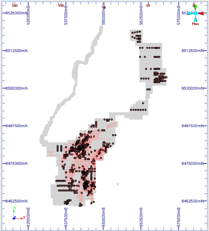
Plan View of drillhole collars showing drillholes not previously announced and used in the MRE update coloured in black, red are all collars, grey outline are current SVM tenements
|
Drillhole |
From |
To |
Length |
Rutile % |
TGC % |
Easting |
Northing |
|
CHHA0002 |
0.0 |
4.0 |
4.0 |
1.27 |
0.01 |
560453.0 |
8518542.1 |
|
CHHA0005 |
0.0 |
4.0 |
4.0 |
0.88 |
1.20 |
559647.0 |
8517013.1 |
|
CHHA0006 |
0.0 |
8.0 |
8.0 |
1.00 |
0.42 |
560398.0 |
8516694.3 |
|
CHHA0007 |
0.0 |
2.0 |
2.0 |
0.77 |
0.20 |
561175.7 |
8516477.8 |
|
CHHA0008 |
0.0 |
6.0 |
6.0 |
1.43 |
0.70 |
561964.6 |
8516377.0 |
|
CHHA0010 |
0.0 |
3.0 |
3.0 |
0.72 |
0.60 |
567400.1 |
8513371.3 |
|
CHHA0011 |
0.0 |
2.0 |
2.0 |
1.09 |
0.01 |
567800.2 |
8513375.4 |
|
CHHA0011 |
9.0 |
11.0 |
2.0 |
0.71 |
4.30 |
567800.2 |
8513375.4 |
|
CHHA0012 |
0.0 |
5.0 |
5.0 |
0.79 |
0.01 |
568199.3 |
8513401.2 |
|
CHHA0013 |
0.0 |
4.0 |
4.0 |
0.81 |
0.40 |
568598.5 |
8513399.1 |
|
CHHA0014 |
0.0 |
5.0 |
5.0 |
0.82 |
0.10 |
568599.6 |
8510403.1 |
|
CHHA0016 |
0.0 |
5.0 |
5.0 |
0.90 |
0.30 |
567800.2 |
8510377.5 |
|
CHHA0017 |
0.0 |
5.0 |
5.0 |
0.87 |
0.60 |
566984.4 |
8510406.3 |
|
CHHA0018 |
0.0 |
13.0 |
13.0 |
1.09 |
1.10 |
567397.1 |
8510378.3 |
|
CHHA0019 |
0.0 |
2.0 |
2.0 |
0.77 |
0.01 |
566998.2 |
8506402.4 |
|
CHHA0020 |
0.0 |
12.0 |
12.0 |
0.74 |
0.59 |
567363.0 |
8506409.9 |
|
CHHA0021 |
0.0 |
5.0 |
5.0 |
0.84 |
0.10 |
567804.2 |
8506431.6 |
|
CHHA0024 |
0.0 |
3.0 |
3.0 |
0.84 |
0.01 |
566999.2 |
8504802.2 |
|
CHHA0025 |
0.0 |
11.0 |
11.0 |
1.12 |
1.53 |
567409.1 |
8504791.2 |
|
CHHA0026 |
0.0 |
3.0 |
3.0 |
1.27 |
0.40 |
567801.6 |
8504799.8 |
|
CHHA0027 |
0.0 |
3.0 |
3.0 |
0.70 |
0.01 |
568189.6 |
8504804.4 |
|
CHHA0028 |
0.0 |
6.0 |
6.0 |
0.79 |
1.15 |
569000.0 |
8504800.2 |
|
CHHA0029 |
0.0 |
4.0 |
4.0 |
0.77 |
0.20 |
569401.5 |
8504800.8 |
|
CHHA0030 |
9.0 |
13.0 |
4.0 |
0.71 |
2.60 |
569800.2 |
8504799.9 |
|
CHHA0032 |
0.0 |
12.0 |
12.0 |
1.23 |
3.32 |
569002.8 |
8503588.0 |
|
CHHA0037 |
0.0 |
4.0 |
4.0 |
1.15 |
0.01 |
570995.9 |
8503603.1 |
|
CHHA0038 |
0.0 |
4.0 |
4.0 |
1.06 |
0.01 |
570602.5 |
8503607.4 |
|
CHHA0040 |
0.0 |
3.0 |
3.0 |
0.82 |
1.60 |
569784.1 |
8503615.6 |
|
CHHA0041 |
0.0 |
12.0 |
12.0 |
0.97 |
3.60 |
569390.4 |
8503587.9 |
|
CHHA0042 |
0.0 |
14.0 |
14.0 |
0.78 |
1.89 |
567396.1 |
8502383.9 |
|
CHHA0043 |
0.0 |
10.0 |
10.0 |
0.89 |
1.68 |
567801.7 |
8502369.0 |
|
CHHA0044 |
0.0 |
13.0 |
13.0 |
0.94 |
2.18 |
568200.4 |
8502398.9 |
|
KYAC0021 |
0.0 |
12.0 |
12.0 |
1.05 |
2.25 |
544800.7 |
8471800.0 |
|
KYAC0041 |
0.0 |
3.0 |
3.0 |
1.18 |
0.01 |
544600.7 |
8472199.8 |
|
KYAC0063 |
0.0 |
23.0 |
23.0 |
0.98 |
1.20 |
543400.6 |
8471399.5 |
|
KYAC0083 |
0.0 |
18.0 |
18.0 |
0.98 |
1.54 |
543952.7 |
8468998.7 |
|
KYAC0103 |
0.0 |
27.0 |
27.0 |
1.08 |
2.11 |
549800.5 |
8479402.3 |
|
KYAC0123 |
0.0 |
29.0 |
29.0 |
1.16 |
1.75 |
548599.5 |
8478398.7 |
|
KYAC0143 |
0.0 |
25.5 |
25.5 |
1.00 |
2.06 |
544000.2 |
8468000.2 |
|
KYAC0163 |
0.0 |
5.0 |
5.0 |
1.16 |
0.30 |
545600.2 |
8464999.3 |
|
KYAC0163 |
27.0 |
29.0 |
2.0 |
0.78 |
3.90 |
545600.2 |
8464999.3 |
|
KYAC0183 |
0.0 |
2.0 |
2.0 |
1.24 |
0.01 |
546198.2 |
8467998.6 |
|
KYAC0183 |
8.0 |
16.0 |
8.0 |
0.92 |
4.15 |
546198.2 |
8467998.6 |
|
KYAC0479 |
8.0 |
20.0 |
12.0 |
1.05 |
|
543498.6 |
8471501.6 |
|
KYAC0480 |
8.0 |
16.0 |
8.0 |
0.98 |
|
543299.0 |
8472101.2 |
|
KYAC0481 |
8.0 |
10.0 |
2.0 |
0.72 |
|
544299.4 |
8471700.0 |
|
KYAC0482 |
8.0 |
18.0 |
10.0 |
0.88 |
|
544700.5 |
8472099.3 |
|
KYAC0483 |
8.0 |
20.0 |
12.0 |
0.87 |
|
543200.1 |
8470200.4 |
|
KYAC0484 |
8.0 |
16.0 |
8.0 |
0.82 |
|
543100.4 |
8469900.9 |
|
KYAC0485 |
6.0 |
8.0 |
2.0 |
0.82 |
|
543399.8 |
8469600.7 |
|
KYAC0486 |
8.0 |
10.0 |
2.0 |
1.04 |
|
543900.2 |
8468101.0 |
|
KYAC0486 |
16.0 |
20.0 |
4.0 |
0.77 |
|
543900.2 |
8468101.0 |
|
KYAC0487 |
8.0 |
20.0 |
12.0 |
0.92 |
|
544499.8 |
8468699.0 |
|
KYAC0488 |
4.0 |
19.0 |
15.0 |
1.41 |
7.19 |
544900.2 |
8472099.1 |
|
KYAC0489 |
6.0 |
12.0 |
6.0 |
0.75 |
1.90 |
544800.2 |
8472200.9 |
|
KYAC0490 |
10.0 |
16.0 |
6.0 |
1.16 |
3.93 |
544900.5 |
8472300.4 |
|
KYAC0492 |
4.0 |
10.0 |
6.0 |
0.70 |
4.43 |
545000.0 |
8472400.1 |
|
KYAC0493 |
4.0 |
6.0 |
2.0 |
0.90 |
2.40 |
544900.0 |
8472500.0 |
|
KYAC0496 |
6.0 |
10.0 |
4.0 |
0.90 |
2.30 |
544700.0 |
8472299.0 |
|
KYAC0499 |
4.0 |
6.0 |
2.0 |
1.11 |
2.00 |
544499.6 |
8472098.0 |
|
KYAC0500 |
4.0 |
18.0 |
14.0 |
0.85 |
3.29 |
543099.1 |
8472300.0 |
|
KYAC0501 |
2.0 |
18.0 |
16.0 |
0.76 |
2.49 |
543098.8 |
8472100.4 |
|
KYAC0502 |
2.0 |
20.0 |
18.0 |
0.85 |
1.54 |
542998.9 |
8472000.0 |
|
KYAC0503 |
4.0 |
6.0 |
2.0 |
0.78 |
3.40 |
542899.1 |
8472100.2 |
|
KYAC0505 |
4.0 |
22.0 |
18.0 |
0.94 |
3.13 |
543499.8 |
8472098.0 |
|
KYAC0506 |
4.0 |
26.5 |
22.5 |
1.03 |
1.94 |
543700.2 |
8472101.0 |
|
KYAC0507 |
4.0 |
13.6 |
9.6 |
1.14 |
2.54 |
543299.8 |
8471901.1 |
|
KYAC0508 |
4.0 |
8.0 |
4.0 |
0.91 |
1.20 |
543098.9 |
8471899.5 |
|
KYAC0509 |
6.0 |
18.1 |
12.1 |
1.01 |
2.40 |
543300.9 |
8472299.9 |
|
KYAC0510 |
12.0 |
23.8 |
11.8 |
0.86 |
2.44 |
544100.2 |
8472099.4 |
|
KYAC0512 |
6.0 |
8.0 |
2.0 |
0.75 |
2.20 |
544700.1 |
8468901.1 |
|
KYAC0513 |
6.0 |
10.0 |
4.0 |
1.40 |
4.95 |
544499.6 |
8468900.4 |
|
KYAC0514 |
6.0 |
18.0 |
12.0 |
0.87 |
2.42 |
544700.8 |
8468700.0 |
|
KYAC0514 |
26.0 |
28.0 |
2.0 |
0.72 |
1.70 |
544700.8 |
8468700.0 |
|
KYAC0515 |
6.0 |
18.0 |
12.0 |
0.77 |
2.12 |
544698.8 |
8468500.1 |
|
KYAC0516 |
6.0 |
18.0 |
12.0 |
0.99 |
2.17 |
544499.8 |
8468501.0 |
|
KYAC0517 |
6.0 |
16.0 |
10.0 |
1.01 |
2.78 |
544500.7 |
8468300.2 |
|
KYAC0518 |
8.0 |
18.0 |
10.0 |
1.04 |
4.20 |
544500.1 |
8468100.8 |
|
KYAC0519 |
4.0 |
18.0 |
14.0 |
1.05 |
2.50 |
544300.0 |
8468701.0 |
|
KYAC0520 |
4.0 |
18.0 |
14.0 |
0.97 |
2.20 |
544300.1 |
8468499.1 |
|
KYAC0521 |
4.0 |
16.0 |
12.0 |
0.82 |
3.67 |
544293.8 |
8468300.4 |
|
KYAC0522 |
6.0 |
25.0 |
19.0 |
1.00 |
1.94 |
544100.5 |
8468301.3 |
|
KYAC0523 |
4.0 |
18.0 |
14.0 |
0.92 |
4.29 |
544102.9 |
8468099.9 |
|
KYAC0524 |
4.0 |
22.0 |
18.0 |
0.85 |
1.42 |
544099.4 |
8468500.1 |
|
KYAC0525 |
2.0 |
18.0 |
16.0 |
1.13 |
2.54 |
543699.3 |
8468100.0 |
|
KYAC0526 |
6.0 |
20.0 |
14.0 |
0.86 |
2.10 |
543699.9 |
8467897.0 |
|
KYAC0527 |
8.0 |
10.0 |
2.0 |
0.85 |
4.70 |
543899.0 |
8467700.1 |
|
KYAC0528 |
6.0 |
10.0 |
4.0 |
1.02 |
0.85 |
544099.3 |
8467699.8 |
|
KYAC0529 |
6.0 |
20.0 |
14.0 |
0.74 |
2.96 |
544299.0 |
8467700.0 |
|
KYAC0531 |
10.0 |
22.0 |
12.0 |
0.82 |
2.52 |
544199.2 |
8467599.9 |
|
KYAC0533 |
6.0 |
8.0 |
2.0 |
0.71 |
0.80 |
544601.1 |
8467600.1 |
|
KYDD0001 |
0.0 |
10.0 |
10.0 |
1.08 |
1.03 |
544499.1 |
8467899.8 |
|
KYDD0001 |
11.0 |
16.0 |
5.0 |
1.06 |
1.84 |
544499.1 |
8467899.8 |
|
KYDD0002 |
0.0 |
6.0 |
6.0 |
0.80 |
2.00 |
543498.9 |
8468099.9 |
|
KYDD0003 |
0.0 |
8.0 |
8.0 |
1.14 |
1.05 |
543699.0 |
8467700.0 |
|
KYDD0003 |
9.0 |
22.0 |
13.0 |
0.89 |
1.72 |
543699.0 |
8467700.0 |
|
KYDD0004 |
0.0 |
17.0 |
17.0 |
1.03 |
3.53 |
544301.2 |
8468099.8 |
|
KYDD0005 |
0.0 |
19.0 |
19.0 |
0.92 |
2.02 |
543900.9 |
8467499.4 |
|
KYDD0006 |
0.0 |
4.0 |
4.0 |
0.93 |
0.13 |
544200.6 |
8466800.4 |
|
KYDD0007 |
0.0 |
15.0 |
15.0 |
1.23 |
1.64 |
544301.0 |
8466500.0 |
|
KYDD0008 |
0.0 |
20.0 |
20.0 |
0.96 |
3.45 |
543900.2 |
8466300.1 |
|
KYDD0009 |
0.0 |
5.0 |
5.0 |
1.55 |
0.20 |
545301.1 |
8465700.3 |
|
KYDD0010 |
0.0 |
23.0 |
23.0 |
0.90 |
1.21 |
545699.0 |
8465499.7 |
|
KYDD0011 |
0.0 |
4.0 |
4.0 |
1.44 |
0.23 |
545299.8 |
8465100.9 |
|
KYDD0011 |
9.0 |
12.0 |
3.0 |
0.95 |
1.53 |
545299.8 |
8465100.9 |
|
KYDD0011 |
16.0 |
18.0 |
2.0 |
0.78 |
1.40 |
545299.8 |
8465100.9 |
|
KYDD0012 |
0.0 |
3.0 |
3.0 |
0.98 |
0.14 |
546099.9 |
8464901.0 |
|
KYDD0013 |
0.0 |
3.0 |
3.0 |
1.66 |
0.10 |
544299.7 |
8472099.4 |
|
KYDD0013 |
11.0 |
16.0 |
5.0 |
0.89 |
1.56 |
544299.7 |
8472099.4 |
|
KYDD0014 |
0.0 |
19.3 |
19.3 |
1.12 |
1.06 |
543899.8 |
8471900.3 |
|
KYDD0015 |
0.0 |
9.0 |
9.0 |
1.62 |
6.37 |
544700.8 |
8471499.5 |
|
KYDD0015 |
10.0 |
22.0 |
12.0 |
0.99 |
3.63 |
544700.8 |
8471499.5 |
|
KYDD0016 |
0.0 |
2.0 |
2.0 |
1.75 |
0.20 |
543501.1 |
8472300.1 |
|
KYDD0016 |
7.0 |
17.0 |
10.0 |
0.82 |
1.24 |
543501.1 |
8472300.1 |
|
KYDD0018 |
0.0 |
11.0 |
11.0 |
1.29 |
1.49 |
543300.2 |
8471700.8 |
|
KYDD0018 |
17.0 |
19.0 |
2.0 |
0.78 |
0.95 |
543300.2 |
8471700.8 |
|
KYDD0019 |
0.0 |
18.0 |
18.0 |
0.82 |
1.58 |
543098.2 |
8471699.8 |
|
KYDD0020 |
0.0 |
3.0 |
3.0 |
1.50 |
0.17 |
542899.9 |
8470101.0 |
|
KYDD0021 |
0.0 |
3.0 |
3.0 |
1.70 |
0.17 |
543400.0 |
8470000.9 |
|
KYDD0021 |
4.0 |
6.0 |
2.0 |
0.93 |
0.76 |
543400.0 |
8470000.9 |
|
KYDD0022 |
0.0 |
7.0 |
7.0 |
1.06 |
0.73 |
543300.4 |
8469700.8 |
|
KYDD0022 |
8.0 |
21.1 |
13.1 |
0.90 |
1.68 |
543300.4 |
8469700.8 |
|
KYDD0023 |
0.0 |
6.0 |
6.0 |
0.76 |
2.32 |
544299.8 |
8470901.3 |
|
KYDD0024 |
0.0 |
12.0 |
12.0 |
0.90 |
0.50 |
543899.8 |
8470499.3 |
|
KYDD0024 |
13.0 |
21.2 |
8.2 |
0.77 |
1.56 |
543899.8 |
8470499.3 |
|
KYDD0025 |
0.0 |
1.0 |
1.0 |
2.27 |
0.60 |
543799.9 |
8470001.2 |
|
KYDD0025 |
2.0 |
9.0 |
7.0 |
0.91 |
1.52 |
543799.9 |
8470001.2 |
|
KYDD0025 |
10.0 |
17.0 |
7.0 |
0.93 |
1.66 |
543799.9 |
8470001.2 |
|
KYDD0026 |
0.0 |
2.0 |
2.0 |
1.24 |
0.45 |
543899.9 |
8469701.0 |
|
KYDD0026 |
6.0 |
21.0 |
15.0 |
0.89 |
2.86 |
543899.9 |
8469701.0 |
|
KYDD0027 |
0.0 |
15.0 |
15.0 |
1.09 |
1.68 |
544300.2 |
8468900.9 |
|
KYDD0028 |
0.0 |
25.0 |
25.0 |
0.85 |
2.72 |
546100.2 |
8467301.1 |
|
KYDD0029 |
0.0 |
6.0 |
6.0 |
1.10 |
2.72 |
546485.2 |
8467899.3 |
|
KYDD0030 |
0.0 |
14.0 |
14.0 |
0.95 |
5.38 |
546098.7 |
8467705.1 |
|
KYHA0023 |
0.0 |
10.0 |
10.0 |
1.01 |
1.36 |
538598.2 |
8478202.8 |
|
KYHA0035 |
0.0 |
10.0 |
10.0 |
1.06 |
1.58 |
538799.7 |
8479200.4 |
|
KYHA0054 |
0.0 |
11.0 |
11.0 |
1.03 |
2.30 |
537598.8 |
8477602.3 |
|
KYHA0055 |
0.0 |
9.5 |
9.5 |
0.80 |
3.12 |
537999.6 |
8477626.7 |
|
KYHA0061 |
0.0 |
7.0 |
7.0 |
0.85 |
3.47 |
538790.0 |
8478777.6 |
|
KYHA0066 |
0.0 |
15.0 |
15.0 |
1.12 |
1.30 |
539599.8 |
8479167.4 |
|
KYHA0078 |
0.0 |
10.0 |
10.0 |
1.12 |
2.33 |
541193.6 |
8481599.6 |
|
KYHA0080 |
0.0 |
2.0 |
2.0 |
1.15 |
0.01 |
541998.9 |
8481598.6 |
|
KYHA0105 |
0.0 |
14.0 |
14.0 |
0.77 |
0.01 |
539192.1 |
8477994.6 |
|
KYHA0120 |
0.0 |
14.0 |
14.0 |
1.24 |
0.01 |
539599.5 |
8479167.7 |
|
KYHA0123 |
0.0 |
4.0 |
4.0 |
1.32 |
0.01 |
539993.0 |
8479995.0 |
|
KYHA0126 |
0.0 |
2.0 |
2.0 |
1.16 |
0.01 |
540001.2 |
8481200.8 |
|
KYHA0133 |
0.0 |
10.0 |
10.0 |
1.53 |
2.32 |
537199.6 |
8477200.6 |
|
KYHA0142 |
3.0 |
6.0 |
3.0 |
1.11 |
0.20 |
540798.9 |
8478800.1 |
|
KYHA0157 |
0.0 |
10.0 |
10.0 |
1.41 |
2.52 |
544029.0 |
8480381.5 |
|
KYHA0161 |
0.0 |
4.0 |
4.0 |
1.48 |
0.10 |
543207.2 |
8482409.4 |
|
KYHA0163 |
0.0 |
2.0 |
2.0 |
1.45 |
0.01 |
542455.0 |
8481633.3 |
|
KYHA0164 |
0.0 |
9.0 |
9.0 |
1.00 |
0.92 |
543166.7 |
8481571.8 |
|
KYHA0171 |
1.0 |
9.0 |
8.0 |
1.47 |
1.78 |
542401.2 |
8480000.8 |
|
KYHA0177 |
0.0 |
11.0 |
11.0 |
1.06 |
0.74 |
543243.3 |
8478790.4 |
|
KYHA0178 |
1.0 |
3.0 |
2.0 |
1.13 |
0.90 |
542399.4 |
8478000.9 |
|
KYHA0182 |
0.0 |
12.0 |
12.0 |
1.30 |
2.14 |
540199.3 |
8479599.0 |
|
KYHA0184 |
0.0 |
11.0 |
11.0 |
0.98 |
1.67 |
540998.4 |
8479605.4 |
|
KYHA0202 |
0.0 |
5.0 |
5.0 |
0.79 |
0.50 |
539398.6 |
8479198.0 |
|
KYHA0235 |
0.0 |
5.0 |
5.0 |
1.11 |
0.20 |
541200.5 |
8478001.0 |
|
KYHA0240 |
0.0 |
3.0 |
3.0 |
1.57 |
0.30 |
541600.6 |
8480399.8 |
|
KYHA0246 |
0.0 |
9.0 |
9.0 |
0.91 |
1.93 |
540798.7 |
8480799.7 |
|
KYHA0256 |
0.0 |
11.0 |
11.0 |
1.19 |
0.01 |
537599.0 |
8477602.1 |
|
KYHA0257 |
0.0 |
14.0 |
14.0 |
0.99 |
0.01 |
538598.1 |
8478202.5 |
|
KYHA0258 |
0.0 |
3.0 |
3.0 |
0.92 |
0.01 |
538789.7 |
8478777.3 |
|
KYHA0259 |
0.0 |
11.0 |
11.0 |
1.31 |
0.01 |
539598.7 |
8479601.1 |
|
KYHA0260 |
0.0 |
4.0 |
4.0 |
1.12 |
0.01 |
539600.7 |
8480400.5 |
|
KYHA0261 |
0.0 |
4.0 |
4.0 |
0.93 |
0.01 |
540001.6 |
8481200.7 |
|
KYHA0262 |
0.0 |
10.0 |
10.0 |
0.91 |
0.01 |
541193.5 |
8481600.0 |
|
KYHA0292 |
0.0 |
8.0 |
8.0 |
1.29 |
1.71 |
537600.9 |
8478798.8 |
|
KYHA0308 |
0.0 |
4.0 |
4.0 |
1.38 |
0.01 |
541200.0 |
8482000.0 |
|
KYHA0315 |
3.0 |
9.0 |
6.0 |
0.89 |
3.67 |
542812.2 |
8479976.7 |
|
KYHA0317 |
0.0 |
3.0 |
3.0 |
1.62 |
0.01 |
542800.1 |
8480800.0 |
|
KYHA0328 |
0.0 |
4.0 |
4.0 |
1.21 |
0.15 |
543199.0 |
8481200.3 |
|
KYHA0330 |
2.0 |
5.0 |
3.0 |
1.02 |
0.90 |
542800.1 |
8481199.8 |
|
KYHA0342 |
2.0 |
12.0 |
10.0 |
0.91 |
0.75 |
543599.4 |
8482799.2 |
|
KYHA0343 |
0.0 |
5.0 |
5.0 |
1.22 |
0.14 |
544002.6 |
8482800.0 |
|
KYHA0399 |
0.0 |
2.0 |
2.0 |
0.71 |
0.01 |
542400.0 |
8477200.8 |
|
KYHA0406 |
4.0 |
7.0 |
3.0 |
1.38 |
0.01 |
540415.0 |
8476800.0 |
|
KYHA0425 |
0.0 |
5.0 |
5.0 |
1.01 |
0.48 |
543600.1 |
8477200.0 |
|
KYHA0451 |
0.0 |
3.0 |
3.0 |
0.78 |
0.01 |
544799.9 |
8476400.0 |
|
KYHA0539 |
0.0 |
11.0 |
11.0 |
0.84 |
2.13 |
540200.4 |
8479198.6 |
|
KYHA0540 |
3.0 |
8.0 |
5.0 |
0.98 |
0.44 |
539649.5 |
8477991.5 |
|
KYHA0542 |
0.0 |
12.0 |
12.0 |
0.88 |
1.83 |
542000.3 |
8476800.9 |
|
KYHA0565 |
0.0 |
3.0 |
3.0 |
1.64 |
0.40 |
542400.5 |
8480001.3 |
|
KYHA0568 |
0.0 |
12.0 |
12.0 |
1.06 |
2.44 |
540596.9 |
8479200.4 |
|
KYHA0571 |
0.0 |
2.0 |
2.0 |
0.70 |
1.40 |
540900.6 |
8476854.4 |
|
KYHA0574 |
0.0 |
12.0 |
12.0 |
0.92 |
1.98 |
542400.6 |
8479601.1 |
|
KYHA0578 |
0.0 |
2.0 |
2.0 |
1.43 |
0.40 |
543197.6 |
8482793.6 |
|
KYHA0579 |
0.0 |
3.0 |
3.0 |
1.09 |
0.40 |
542400.8 |
8476798.8 |
|
KYHA0580 |
0.0 |
1.0 |
1.0 |
0.79 |
0.40 |
543998.9 |
8477999.2 |
|
KYHA0581 |
0.0 |
3.0 |
3.0 |
1.09 |
0.50 |
544000.1 |
8478799.1 |
|
KYHA0582 |
0.0 |
4.0 |
4.0 |
0.75 |
0.30 |
545202.6 |
8476399.9 |
|
KYHA0804 |
0.0 |
11.0 |
11.0 |
1.34 |
1.31 |
549198.9 |
8479601.8 |
|
KYHA0811 |
0.0 |
12.0 |
12.0 |
1.27 |
1.53 |
548798.8 |
8479197.9 |
|
KYHA0818 |
0.0 |
12.0 |
12.0 |
1.26 |
1.53 |
548398.8 |
8478798.4 |
|
KYHA0837 |
0.0 |
12.0 |
12.0 |
1.46 |
1.68 |
548799.3 |
8478401.7 |
|
KYHA0838 |
0.0 |
12.0 |
12.0 |
1.34 |
1.00 |
548399.6 |
8478399.1 |
|
KYHA0898 |
0.0 |
3.0 |
3.0 |
0.95 |
0.50 |
539200.6 |
8480203.0 |
|
KYHA0899 |
0.0 |
2.0 |
2.0 |
1.45 |
0.50 |
539606.6 |
8480200.3 |
|
KYHA0899 |
7.0 |
12.0 |
5.0 |
0.98 |
6.10 |
539606.6 |
8480200.3 |
|
KYHA0900 |
0.0 |
2.0 |
2.0 |
0.79 |
0.40 |
540000.9 |
8480199.9 |
|
KYHA0900 |
10.0 |
12.0 |
2.0 |
0.78 |
2.90 |
540000.9 |
8480199.9 |
|
KYHA0901 |
0.0 |
13.0 |
13.0 |
1.35 |
2.42 |
539204.2 |
8479800.8 |
|
KYHA0902 |
0.0 |
6.0 |
6.0 |
1.31 |
1.75 |
539601.7 |
8479802.0 |
|
KYHA0903 |
0.0 |
11.0 |
11.0 |
1.16 |
2.20 |
540001.5 |
8479800.5 |
|
KYHA0904 |
0.0 |
12.0 |
12.0 |
1.27 |
2.55 |
539199.8 |
8479402.0 |
|
KYHA0905 |
0.0 |
13.0 |
13.0 |
1.23 |
3.28 |
539598.7 |
8479403.0 |
|
KYHA0906 |
0.0 |
13.0 |
13.0 |
1.18 |
2.95 |
540400.7 |
8479803.0 |
|
KYHA0907 |
0.0 |
10.0 |
10.0 |
0.87 |
0.88 |
540402.9 |
8479402.0 |
|
KYHA0908 |
0.0 |
7.0 |
7.0 |
1.03 |
0.37 |
540801.9 |
8479806.6 |
|
KYHA0909 |
0.0 |
6.0 |
6.0 |
1.25 |
0.33 |
541202.9 |
8479802.7 |
|
KYHA0910 |
0.0 |
2.0 |
2.0 |
1.17 |
0.30 |
541600.5 |
8479795.2 |
|
KYHA0911 |
0.0 |
10.0 |
10.0 |
1.08 |
1.58 |
541799.6 |
8479602.8 |
|
KYHA0912 |
0.0 |
8.0 |
8.0 |
1.35 |
0.86 |
541200.7 |
8479401.7 |
|
KYHA0913 |
0.0 |
12.0 |
12.0 |
1.12 |
2.73 |
541603.4 |
8479403.3 |
|
KYHA0914 |
0.0 |
12.0 |
12.0 |
1.31 |
3.12 |
540799.5 |
8479001.5 |
|
KYHA0915 |
0.0 |
4.0 |
4.0 |
1.21 |
0.35 |
541203.3 |
8479000.6 |
|
KYHA0916 |
0.0 |
12.0 |
12.0 |
1.37 |
1.03 |
542200.8 |
8479606.1 |
|
KYHA0917 |
0.0 |
3.0 |
3.0 |
1.41 |
0.40 |
542600.8 |
8479605.0 |
|
KYHA0918 |
0.0 |
5.0 |
5.0 |
1.47 |
0.20 |
541998.4 |
8479799.5 |
|
KYHA0920 |
0.0 |
11.0 |
11.0 |
1.02 |
1.45 |
542400.8 |
8479403.3 |
|
KYHA0921 |
0.0 |
12.0 |
12.0 |
1.01 |
2.98 |
538798.7 |
8479003.5 |
|
KYHA0922 |
0.0 |
2.0 |
2.0 |
1.02 |
1.20 |
539197.7 |
8479002.4 |
|
KYHA0923 |
0.0 |
6.0 |
6.0 |
0.90 |
2.10 |
541597.3 |
8479000.9 |
|
KYHA0924 |
0.0 |
3.0 |
3.0 |
1.39 |
0.30 |
540793.1 |
8479396.3 |
|
KYHA0925 |
0.0 |
4.0 |
4.0 |
1.35 |
0.25 |
542400.7 |
8479803.3 |
|
KYHA0926 |
0.0 |
12.0 |
12.0 |
1.08 |
1.08 |
542198.0 |
8480003.7 |
|
KYHA0927 |
0.0 |
11.0 |
11.0 |
1.46 |
1.37 |
542399.7 |
8480199.7 |
|
KYHA0928 |
0.0 |
4.0 |
4.0 |
1.37 |
1.00 |
542003.9 |
8480199.4 |
|
KYHA0929 |
0.0 |
8.0 |
8.0 |
1.14 |
1.16 |
542200.2 |
8480401.0 |
|
KYHA0930 |
0.0 |
1.0 |
1.0 |
2.10 |
0.30 |
541792.0 |
8480398.1 |
|
KYHA0931 |
0.0 |
3.0 |
3.0 |
1.93 |
0.20 |
542597.7 |
8480801.2 |
|
KYHA0932 |
0.0 |
2.0 |
2.0 |
1.71 |
0.20 |
542004.1 |
8480600.9 |
|
KYHA0933 |
0.0 |
8.0 |
8.0 |
1.44 |
1.03 |
542399.2 |
8480599.3 |
|
KYHA0934 |
0.0 |
2.0 |
2.0 |
1.93 |
0.40 |
542189.8 |
8480801.8 |
|
KYHA0935 |
0.0 |
6.0 |
6.0 |
0.98 |
1.23 |
541799.3 |
8480002.4 |
|
KYHA0936 |
0.0 |
8.0 |
8.0 |
1.24 |
0.80 |
542600.6 |
8480002.5 |
|
KYHA0937 |
0.0 |
14.0 |
14.0 |
1.46 |
1.39 |
542800.6 |
8480200.3 |
|
KYHA0938 |
0.0 |
12.0 |
12.0 |
1.53 |
1.09 |
543003.1 |
8480401.5 |
|
KYHA0939 |
0.0 |
14.0 |
14.0 |
1.13 |
1.49 |
543202.0 |
8480201.7 |
|
KYHA0940 |
0.0 |
2.0 |
2.0 |
1.28 |
0.30 |
544003.1 |
8480202.5 |
|
KYHA0941 |
0.0 |
7.0 |
7.0 |
1.29 |
0.31 |
543402.0 |
8480402.6 |
|
KYHA0942 |
0.0 |
14.0 |
14.0 |
1.18 |
1.72 |
543600.4 |
8480204.5 |
|
KYHA0943 |
0.0 |
15.0 |
15.0 |
1.39 |
0.82 |
544200.6 |
8480401.3 |
|
KYHA0944 |
0.0 |
12.0 |
12.0 |
0.96 |
0.85 |
542600.7 |
8480399.8 |
|
KYHA0945 |
0.0 |
5.0 |
5.0 |
0.95 |
0.05 |
543199.4 |
8479397.3 |
|
KYHA0945 |
11.0 |
13.0 |
2.0 |
0.73 |
1.90 |
543199.4 |
8479397.3 |
|
KYHA0946 |
0.0 |
14.0 |
14.0 |
0.86 |
1.45 |
543400.3 |
8479198.0 |
|
KYHA0947 |
0.0 |
6.0 |
6.0 |
1.19 |
0.40 |
543210.0 |
8478999.1 |
|
KYHA0948 |
0.0 |
8.0 |
8.0 |
1.16 |
3.00 |
543599.6 |
8478999.8 |
|
KYHA0949 |
0.0 |
4.0 |
4.0 |
1.11 |
0.30 |
543798.6 |
8479202.6 |
|
KYHA0950 |
0.0 |
13.0 |
13.0 |
0.93 |
1.70 |
543601.1 |
8479403.6 |
|
KYHA0951 |
0.0 |
14.0 |
14.0 |
1.11 |
0.99 |
544398.1 |
8480601.7 |
|
KYHA0952 |
0.0 |
12.0 |
12.0 |
0.93 |
0.82 |
544599.3 |
8480800.7 |
|
KYHA0953 |
0.0 |
15.0 |
15.0 |
0.95 |
1.83 |
544803.0 |
8480998.8 |
|
KYHA0954 |
0.0 |
13.0 |
13.0 |
1.08 |
0.95 |
542798.4 |
8480599.9 |
|
KYHA0955 |
0.0 |
11.0 |
11.0 |
1.30 |
1.05 |
543202.2 |
8480599.8 |
|
KYHA0956 |
0.0 |
8.0 |
8.0 |
1.10 |
1.43 |
543402.7 |
8480801.7 |
|
KYHA0957 |
0.0 |
4.0 |
4.0 |
1.39 |
0.06 |
543004.8 |
8480805.5 |
|
KYHA0958 |
0.0 |
7.0 |
7.0 |
1.23 |
0.20 |
543601.2 |
8480999.8 |
|
KYHA0959 |
0.0 |
12.0 |
12.0 |
1.01 |
2.22 |
543801.4 |
8480799.3 |
|
KYHA0960 |
0.0 |
15.0 |
15.0 |
1.26 |
1.48 |
543998.7 |
8480601.1 |
|
KYHA0961 |
0.0 |
14.0 |
14.0 |
1.01 |
2.31 |
543602.3 |
8480599.0 |
|
KYHA0962 |
0.0 |
13.0 |
13.0 |
1.20 |
0.88 |
543798.4 |
8480407.6 |
|
KYHA0963 |
0.0 |
14.0 |
14.0 |
1.22 |
2.24 |
544001.1 |
8481006.1 |
|
KYHA0964 |
0.0 |
10.0 |
10.0 |
1.15 |
2.39 |
544203.0 |
8480801.1 |
|
KYHA0965 |
0.0 |
12.0 |
12.0 |
1.14 |
1.62 |
544402.9 |
8481000.7 |
|
KYHA0966 |
0.0 |
6.0 |
6.0 |
1.17 |
0.37 |
544602.0 |
8481201.7 |
|
KYHA0967 |
0.0 |
8.0 |
8.0 |
0.90 |
0.64 |
544999.3 |
8481221.4 |
|
KYHA0968 |
0.0 |
8.0 |
8.0 |
1.31 |
0.63 |
544800.3 |
8481399.7 |
|
KYHA0969 |
0.0 |
2.0 |
2.0 |
1.60 |
0.30 |
544409.2 |
8481401.5 |
|
KYHA0970 |
0.0 |
2.0 |
2.0 |
1.49 |
0.30 |
544198.6 |
8481204.6 |
|
KYHA0971 |
0.0 |
2.0 |
2.0 |
1.20 |
0.60 |
543600.6 |
8478599.5 |
|
KYHA0972 |
0.0 |
9.0 |
9.0 |
1.36 |
0.99 |
543401.0 |
8478801.4 |
|
KYHA0973 |
0.0 |
5.0 |
5.0 |
1.12 |
0.38 |
543397.9 |
8478401.4 |
|
KYHA0974 |
0.0 |
12.0 |
12.0 |
0.95 |
1.97 |
543395.8 |
8477999.4 |
|
KYHA0975 |
0.0 |
13.0 |
13.0 |
0.87 |
1.68 |
543601.6 |
8477802.3 |
|
KYHA0976 |
0.0 |
12.0 |
12.0 |
1.22 |
1.91 |
543206.7 |
8477791.5 |
|
KYHA0977 |
0.0 |
3.0 |
3.0 |
1.16 |
0.20 |
542997.7 |
8477999.4 |
|
KYHA0978 |
0.0 |
14.0 |
14.0 |
1.09 |
1.94 |
543597.2 |
8478200.4 |
|
KYHA0979 |
0.0 |
5.0 |
5.0 |
1.00 |
0.36 |
543199.4 |
8478200.0 |
|
KYHA0980 |
0.0 |
12.0 |
12.0 |
1.16 |
1.45 |
543200.9 |
8478602.1 |
|
KYHA0981 |
0.0 |
11.0 |
11.0 |
0.96 |
2.03 |
543005.3 |
8478395.9 |
|
KYHA0983 |
0.0 |
15.0 |
15.0 |
0.90 |
3.46 |
543600.8 |
8481800.4 |
|
KYHA0984 |
0.0 |
14.0 |
14.0 |
1.17 |
2.49 |
539996.8 |
8479401.4 |
|
KYHA0985 |
0.0 |
4.0 |
4.0 |
1.00 |
0.50 |
543402.2 |
8481602.2 |
|
KYHA0987 |
0.0 |
15.0 |
15.0 |
1.17 |
1.73 |
543398.1 |
8482001.5 |
|
KYHA0988 |
0.0 |
5.0 |
5.0 |
1.15 |
0.24 |
543196.4 |
8482201.4 |
|
KYHA0989 |
0.0 |
8.0 |
8.0 |
1.16 |
1.63 |
541802.9 |
8480803.4 |
|
KYHA0990 |
0.0 |
14.0 |
14.0 |
1.35 |
1.36 |
543202.5 |
8481800.1 |
|
KYHA0991 |
0.0 |
10.0 |
10.0 |
1.02 |
4.04 |
543598.5 |
8482203.6 |
|
KYHA0992 |
0.0 |
11.0 |
11.0 |
1.02 |
1.26 |
543402.7 |
8482405.4 |
|
KYHA0993 |
0.0 |
2.0 |
2.0 |
1.49 |
0.40 |
543808.5 |
8482399.3 |
|
KYHA0994 |
0.0 |
12.0 |
12.0 |
0.94 |
0.83 |
543600.8 |
8482600.2 |
|
KYHA0995 |
0.0 |
3.0 |
3.0 |
1.53 |
0.20 |
543997.9 |
8482597.4 |
|
KYHA0996 |
0.0 |
4.0 |
4.0 |
1.50 |
0.20 |
543798.5 |
8482803.1 |
|
KYHA0997 |
0.0 |
5.0 |
5.0 |
1.09 |
0.46 |
544197.2 |
8483202.8 |
|
KYHA0998 |
0.0 |
6.0 |
6.0 |
0.84 |
2.50 |
544599.6 |
8483200.6 |
|
KYHA0999 |
0.0 |
2.0 |
2.0 |
1.15 |
0.40 |
544399.5 |
8483000.3 |
|
KYHA1000 |
0.0 |
3.0 |
3.0 |
1.32 |
0.20 |
544401.8 |
8483401.1 |
|
KYHA1001 |
0.0 |
10.0 |
10.0 |
0.89 |
2.87 |
544202.1 |
8483597.8 |
|
KYHA1002 |
0.0 |
13.0 |
13.0 |
1.38 |
1.10 |
544603.2 |
8483602.9 |
|
KYHA1003 |
0.0 |
15.0 |
15.0 |
1.12 |
3.01 |
545003.8 |
8483599.5 |
|
KYHA1004 |
0.0 |
14.0 |
14.0 |
1.48 |
1.51 |
544801.5 |
8483801.2 |
|
KYHA1005 |
0.0 |
9.0 |
9.0 |
0.93 |
1.13 |
544598.4 |
8484002.5 |
|
KYHA1006 |
0.0 |
15.0 |
15.0 |
1.07 |
3.00 |
545200.2 |
8483797.5 |
|
KYHA1007 |
0.0 |
10.0 |
10.0 |
1.05 |
1.11 |
545001.2 |
8484006.3 |
|
KYHA1008 |
0.0 |
7.0 |
7.0 |
1.04 |
0.57 |
544002.3 |
8483400.0 |
|
KYHA1009 |
0.0 |
4.0 |
4.0 |
1.41 |
0.50 |
544399.9 |
8483801.6 |
|
KYHA1010 |
0.0 |
3.0 |
3.0 |
1.52 |
0.60 |
544801.6 |
8483401.9 |
|
KYHA1011 |
0.0 |
2.0 |
2.0 |
0.92 |
0.30 |
544199.9 |
8482801.2 |
|
KYHA1011 |
7.0 |
11.0 |
4.0 |
0.89 |
1.45 |
544199.9 |
8482801.2 |
|
KYHA1012 |
0.0 |
3.0 |
3.0 |
1.32 |
0.20 |
543993.9 |
8483002.6 |
|
KYHA1013 |
0.0 |
5.0 |
5.0 |
1.15 |
0.56 |
541602.8 |
8481802.1 |
|
KYHA1013 |
10.0 |
13.0 |
3.0 |
0.77 |
4.40 |
541602.8 |
8481802.1 |
|
KYHA1014 |
0.0 |
15.0 |
15.0 |
0.87 |
3.17 |
541800.5 |
8482000.4 |
|
KYHA1015 |
0.0 |
10.0 |
10.0 |
1.01 |
1.66 |
542001.3 |
8482199.9 |
|
KYHA1016 |
0.0 |
4.0 |
4.0 |
1.38 |
0.95 |
543556.7 |
8483013.2 |
|
KYHA1018 |
0.0 |
12.0 |
12.0 |
1.01 |
1.93 |
541999.8 |
8482597.6 |
|
KYHA1019 |
0.0 |
14.0 |
14.0 |
1.33 |
2.07 |
541799.2 |
8482404.1 |
|
KYHA1020 |
0.0 |
15.0 |
15.0 |
1.18 |
2.89 |
541597.1 |
8482205.0 |
|
KYHA1021 |
0.0 |
4.0 |
4.0 |
1.33 |
0.35 |
541400.1 |
8481999.9 |
|
KYHA1021 |
9.0 |
11.0 |
2.0 |
0.93 |
4.30 |
541400.1 |
8481999.9 |
|
KYHA1022 |
0.0 |
12.0 |
12.0 |
1.28 |
2.38 |
541197.4 |
8481803.0 |
|
KYHA1023 |
0.0 |
12.0 |
12.0 |
1.26 |
2.60 |
541396.9 |
8481601.7 |
|
KYHA1024 |
0.0 |
12.0 |
12.0 |
0.91 |
2.48 |
542199.4 |
8482402.7 |
|
KYHA1025 |
0.0 |
6.0 |
6.0 |
1.08 |
0.27 |
541602.0 |
8482601.8 |
|
KYHA1025 |
13.0 |
15.0 |
2.0 |
0.77 |
3.60 |
541602.0 |
8482601.8 |
|
KYHA1026 |
0.0 |
2.0 |
2.0 |
1.22 |
0.30 |
541402.1 |
8482400.0 |
|
KYHA1027 |
0.0 |
4.0 |
4.0 |
1.02 |
0.15 |
541203.2 |
8482200.4 |
|
KYHA1028 |
0.0 |
14.0 |
14.0 |
1.16 |
1.92 |
541003.2 |
8481601.0 |
|
KYHA1029 |
0.0 |
12.0 |
12.0 |
0.91 |
2.64 |
540802.4 |
8481400.7 |
|
KYHA1030 |
0.0 |
13.0 |
13.0 |
0.91 |
3.12 |
541201.0 |
8481401.4 |
|
KYHA1031 |
0.0 |
10.0 |
10.0 |
1.01 |
3.30 |
540998.4 |
8481209.6 |
|
KYHA1032 |
0.0 |
2.0 |
2.0 |
1.39 |
0.40 |
537403.1 |
8476804.0 |
|
KYHA1033 |
0.0 |
2.0 |
2.0 |
1.33 |
0.50 |
536999.1 |
8476800.4 |
|
KYHA1033 |
10.0 |
14.0 |
4.0 |
1.22 |
3.90 |
536999.1 |
8476800.4 |
|
KYHA1034 |
0.0 |
16.0 |
16.0 |
0.97 |
3.78 |
537200.6 |
8476999.2 |
|
KYHA1035 |
0.0 |
9.0 |
9.0 |
0.97 |
1.39 |
537399.2 |
8477200.3 |
|
KYHA1036 |
0.0 |
3.0 |
3.0 |
1.24 |
0.70 |
537000.0 |
8477204.5 |
|
KYHA1037 |
0.0 |
14.0 |
14.0 |
1.28 |
1.93 |
537200.6 |
8477397.5 |
|
KYHA1038 |
0.0 |
12.0 |
12.0 |
0.97 |
1.13 |
537001.5 |
8477603.4 |
|
KYHA1039 |
0.0 |
10.0 |
10.0 |
1.33 |
2.65 |
537405.8 |
8477595.8 |
|
KYHA1040 |
0.0 |
3.0 |
3.0 |
2.00 |
1.23 |
537599.0 |
8477802.7 |
|
KYHA1041 |
0.0 |
2.0 |
2.0 |
1.85 |
1.60 |
537793.2 |
8478002.7 |
|
KYHA1042 |
0.0 |
2.0 |
2.0 |
1.53 |
0.60 |
537799.4 |
8477602.5 |
|
KYHA1043 |
0.0 |
6.0 |
6.0 |
1.34 |
2.40 |
537999.7 |
8477798.9 |
|
KYHA1044 |
0.0 |
2.0 |
2.0 |
1.31 |
0.50 |
537594.1 |
8477396.0 |
|
KYHA1044 |
9.0 |
12.0 |
3.0 |
0.93 |
3.40 |
537594.1 |
8477396.0 |
|
KYHA1045 |
0.0 |
2.0 |
2.0 |
1.36 |
0.30 |
538000.3 |
8477401.8 |
|
KYHA1046 |
0.0 |
11.0 |
11.0 |
0.90 |
3.50 |
537202.0 |
8477799.0 |
|
KYHA1047 |
0.0 |
2.0 |
2.0 |
1.33 |
0.70 |
537400.9 |
8477999.7 |
|
KYHA1048 |
0.0 |
8.0 |
8.0 |
1.03 |
4.05 |
538202.5 |
8477999.0 |
|
KYHA1049 |
0.0 |
2.0 |
2.0 |
1.76 |
0.30 |
540600.2 |
8479800.5 |
|
KYHA1049 |
8.0 |
12.0 |
4.0 |
0.96 |
3.90 |
540600.2 |
8479800.5 |
|
KYHA1050 |
0.0 |
10.0 |
10.0 |
1.11 |
0.12 |
542202.2 |
8479803.0 |
|
KYHA1051 |
0.0 |
8.0 |
8.0 |
1.48 |
0.80 |
542199.9 |
8480600.2 |
|
KYHA1052 |
0.0 |
8.0 |
8.0 |
1.34 |
1.88 |
543400.0 |
8480600.5 |
|
KYHA1053 |
0.0 |
14.0 |
14.0 |
0.86 |
0.73 |
543799.9 |
8480200.5 |
|
KYHA1054 |
0.0 |
14.0 |
14.0 |
1.28 |
1.23 |
539800.1 |
8479400.6 |
|
KYHA1055 |
0.0 |
4.0 |
4.0 |
1.12 |
0.40 |
543800.0 |
8479000.4 |
|
KYHA1056 |
0.0 |
11.0 |
11.0 |
1.33 |
2.56 |
543398.0 |
8478599.4 |
|
KYHA1057 |
0.0 |
6.0 |
6.0 |
1.48 |
0.37 |
541007.2 |
8481390.6 |
|
KYHA1058 |
0.0 |
10.0 |
10.0 |
1.12 |
2.06 |
541395.1 |
8481801.5 |
|
KYHA1059 |
0.0 |
2.0 |
2.0 |
1.42 |
0.30 |
544600.0 |
8482600.3 |
|
KYHA1060 |
0.0 |
6.0 |
6.0 |
0.98 |
0.43 |
544600.0 |
8483000.2 |
|
KYHA1061 |
0.0 |
10.0 |
10.0 |
1.23 |
0.44 |
544599.9 |
8483800.5 |
|
KYHA1062 |
0.0 |
12.0 |
12.0 |
1.39 |
1.50 |
544600.0 |
8481001.0 |
|
KYHA1063 |
0.0 |
8.0 |
8.0 |
0.92 |
1.58 |
537799.8 |
8477800.3 |
|
KYHA1064 |
0.0 |
11.0 |
11.0 |
1.21 |
3.23 |
537000.0 |
8477400.5 |
|
KYHA1065 |
0.0 |
14.0 |
14.0 |
1.18 |
2.00 |
539798.0 |
8472799.4 |
|
KYHA1066 |
0.0 |
4.0 |
4.0 |
1.21 |
0.30 |
538998.0 |
8472802.8 |
|
KYHA1068 |
0.0 |
2.0 |
2.0 |
0.85 |
0.30 |
550438.0 |
8479180.0 |
|
KYHA1079 |
0.0 |
4.0 |
4.0 |
0.85 |
0.40 |
550833.6 |
8480356.2 |
|
KYHA1080 |
0.0 |
10.0 |
10.0 |
1.01 |
0.66 |
550806.6 |
8479996.4 |
|
KYHA1081 |
0.0 |
2.0 |
2.0 |
1.20 |
0.10 |
550799.4 |
8479599.8 |
|
KYHA1114 |
0.0 |
3.0 |
3.0 |
1.09 |
0.20 |
549200.4 |
8476799.3 |
|
KYHA1115 |
0.0 |
2.0 |
2.0 |
1.13 |
0.30 |
548399.8 |
8478004.8 |
|
KYHA1126 |
0.0 |
3.0 |
3.0 |
1.15 |
0.20 |
542400.4 |
8484801.3 |
|
KYHA1136 |
0.0 |
4.0 |
4.0 |
1.23 |
0.30 |
543000.2 |
8484596.8 |
|
KYHA1138 |
0.0 |
13.0 |
13.0 |
0.90 |
3.92 |
542599.4 |
8484601.1 |
|
KYHA1141 |
0.0 |
10.0 |
10.0 |
1.25 |
3.37 |
542599.6 |
8484205.8 |
|
KYHA1143 |
0.0 |
5.0 |
5.0 |
0.98 |
0.30 |
542999.2 |
8484204.4 |
|
KYHA1145 |
0.0 |
3.0 |
3.0 |
1.15 |
0.30 |
542000.1 |
8483604.7 |
|
KYHA1151 |
0.0 |
4.0 |
4.0 |
0.78 |
0.40 |
547202.5 |
8473202.6 |
|
KYHA1173 |
0.0 |
12.0 |
12.0 |
1.65 |
1.88 |
544800.0 |
8472000.0 |
|
KYHA1206 |
0.0 |
9.0 |
9.0 |
0.97 |
1.07 |
542797.5 |
8465200.6 |
|
KYHA1228 |
0.0 |
2.0 |
2.0 |
0.78 |
0.20 |
547202.7 |
8479201.6 |
|
KYHA1231 |
0.0 |
4.0 |
4.0 |
1.00 |
0.25 |
543798.7 |
8479203.1 |
|
KYHA1232 |
0.0 |
6.0 |
6.0 |
1.33 |
0.20 |
540797.8 |
8478800.2 |
|
KYHA1232 |
13.0 |
16.0 |
3.0 |
0.89 |
0.20 |
540797.8 |
8478800.2 |
|
KYHA1233 |
2.0 |
10.0 |
8.0 |
1.13 |
0.88 |
541202.7 |
8479802.8 |
|
KYHA1234 |
0.0 |
5.0 |
5.0 |
1.38 |
0.90 |
542200.7 |
8480401.6 |
|
KYHA1235 |
0.0 |
2.0 |
2.0 |
1.39 |
0.20 |
545616.8 |
8480378.4 |
|
KYHA1236 |
0.0 |
2.0 |
2.0 |
1.47 |
0.40 |
540802.6 |
8481400.2 |
|
KYHA1236 |
7.0 |
12.0 |
5.0 |
1.05 |
3.78 |
540802.6 |
8481400.2 |
|
KYHA1237 |
0.0 |
8.0 |
8.0 |
1.11 |
1.50 |
541802.9 |
8480803.7 |
|
KYHA1238 |
0.0 |
4.0 |
4.0 |
1.44 |
0.40 |
544399.8 |
8483801.9 |
|
KYHA1238 |
10.0 |
12.0 |
2.0 |
0.79 |
3.10 |
544399.8 |
8483801.9 |
|
KYHA1239 |
0.0 |
3.0 |
3.0 |
0.83 |
0.20 |
544800.4 |
8484401.2 |
|
KYHA1240 |
0.0 |
8.0 |
8.0 |
1.24 |
0.55 |
544800.1 |
8481400.0 |
|
KYHA1241 |
0.0 |
11.0 |
11.0 |
0.94 |
0.95 |
546795.7 |
8484005.9 |
|
KYHA1242 |
0.0 |
3.0 |
3.0 |
0.70 |
0.20 |
548400.3 |
8485999.0 |
|
KYHA1243 |
0.0 |
7.0 |
7.0 |
1.08 |
0.87 |
537598.7 |
8472000.6 |
|
KYHA1244 |
0.0 |
5.0 |
5.0 |
1.15 |
0.20 |
540398.6 |
8473200.9 |
|
KYHA1245 |
0.0 |
7.0 |
7.0 |
1.00 |
1.44 |
537599.6 |
8480402.2 |
|
KYHA1246 |
0.0 |
12.0 |
12.0 |
1.09 |
0.85 |
543597.3 |
8473199.3 |
|
KYHA1249 |
0.0 |
11.0 |
11.0 |
1.08 |
1.27 |
546800.3 |
8476401.0 |
|
KYHA1252 |
0.0 |
11.0 |
11.0 |
1.47 |
1.78 |
544404.8 |
8472006.1 |
|
KYHA1253 |
0.0 |
5.0 |
5.0 |
0.78 |
0.40 |
547200.6 |
8472400.5 |
|
KYHA1256 |
0.0 |
11.0 |
11.0 |
1.14 |
0.85 |
542800.1 |
8470398.8 |
|
KYHA1257 |
0.0 |
9.0 |
9.0 |
1.20 |
0.94 |
544796.4 |
8467603.6 |
|
KYHA1258 |
5.0 |
7.0 |
2.0 |
0.79 |
1.20 |
545201.2 |
8467200.6 |
|
KYHA1260 |
0.0 |
2.0 |
2.0 |
1.22 |
0.30 |
542000.3 |
8468800.3 |
|
KYHA1261 |
0.0 |
10.0 |
10.0 |
1.49 |
1.00 |
544000.3 |
8468409.6 |
|
KYHA1263 |
0.0 |
5.0 |
5.0 |
0.84 |
0.30 |
546801.0 |
8462199.3 |
|
KYHA1265 |
0.0 |
3.0 |
3.0 |
1.33 |
0.01 |
546001.0 |
8465997.1 |
|
KYHA1266 |
0.0 |
5.0 |
5.0 |
0.84 |
0.96 |
544799.3 |
8464400.0 |
|
KYHA1328 |
2.0 |
4.0 |
2.0 |
1.03 |
0.20 |
541200.5 |
8467602.6 |
|
KYHA1328 |
12.0 |
14.0 |
2.0 |
1.78 |
1.60 |
541200.5 |
8467602.6 |
|
KYHA1329 |
0.0 |
3.0 |
3.0 |
0.73 |
0.20 |
540406.8 |
8467602.0 |
|
KYHA1330 |
0.0 |
2.0 |
2.0 |
0.88 |
0.10 |
540000.6 |
8467602.4 |
|
KYHA1330 |
12.0 |
14.0 |
2.0 |
1.40 |
1.60 |
540000.6 |
8467602.4 |
|
KYHA1331 |
11.0 |
14.0 |
3.0 |
1.64 |
1.80 |
539598.7 |
8467598.8 |
|
KYHA1332 |
6.0 |
9.0 |
3.0 |
0.78 |
0.20 |
539200.6 |
8467600.1 |
|
KYHA1333 |
2.0 |
4.0 |
2.0 |
2.03 |
0.01 |
545999.8 |
8469985.6 |
|
KYHA1336 |
0.0 |
2.0 |
2.0 |
1.17 |
0.01 |
545997.0 |
8469601.0 |
|
KYHA1343 |
0.0 |
2.0 |
2.0 |
1.27 |
0.20 |
546399.1 |
8473202.4 |
|
KYHA1346 |
6.0 |
8.0 |
2.0 |
1.10 |
1.80 |
545201.8 |
8473202.2 |
|
KYHA1349 |
0.0 |
3.0 |
3.0 |
1.14 |
0.50 |
545997.4 |
8473998.4 |
|
KYHA1350 |
2.0 |
14.0 |
12.0 |
1.20 |
1.26 |
539589.6 |
8469201.2 |
|
KYHA1351 |
0.0 |
14.0 |
14.0 |
1.00 |
1.69 |
540001.6 |
8469199.1 |
|
KYHA1352 |
2.0 |
11.0 |
9.0 |
0.88 |
3.42 |
540802.5 |
8469200.1 |
|
KYHA1357 |
0.0 |
3.0 |
3.0 |
1.35 |
0.01 |
534800.8 |
8479201.8 |
|
KYHA1358 |
0.0 |
8.0 |
8.0 |
0.98 |
0.13 |
536001.7 |
8480798.3 |
|
KYHA1359 |
0.0 |
2.0 |
2.0 |
0.89 |
0.20 |
535995.5 |
8480399.7 |
|
KYHA1360 |
4.0 |
7.0 |
3.0 |
0.91 |
0.50 |
536000.1 |
8479999.2 |
|
KYHA1363 |
0.0 |
2.0 |
2.0 |
1.09 |
0.01 |
539204.0 |
8466000.4 |
|
KYHA1364 |
0.0 |
2.0 |
2.0 |
1.38 |
0.01 |
539601.9 |
8466000.0 |
|
KYHA1365 |
2.0 |
12.0 |
10.0 |
0.94 |
0.91 |
539999.1 |
8466000.5 |
|
KYHA1366 |
0.0 |
3.0 |
3.0 |
0.84 |
0.01 |
540399.4 |
8465998.7 |
|
KYHA1367 |
0.0 |
11.0 |
11.0 |
0.97 |
0.82 |
541195.9 |
8465996.3 |
|
KYHA1368 |
6.0 |
8.0 |
2.0 |
0.88 |
3.30 |
540401.1 |
8465600.0 |
|
KYHA1369 |
2.0 |
5.0 |
3.0 |
1.07 |
0.20 |
540800.8 |
8465601.2 |
|
KYHA1372 |
0.0 |
14.0 |
14.0 |
1.13 |
1.19 |
541198.9 |
8465207.4 |
|
KYHA1373 |
0.0 |
2.0 |
2.0 |
1.36 |
0.30 |
538805.0 |
8466000.7 |
|
KYHA1381 |
0.0 |
3.0 |
3.0 |
0.76 |
0.01 |
535606.4 |
8465996.1 |
|
KYHA1385 |
0.0 |
2.0 |
2.0 |
0.70 |
0.01 |
535600.5 |
8467602.5 |
|
KYHA1390 |
0.0 |
2.0 |
2.0 |
0.78 |
0.30 |
536868.0 |
8467600.7 |
|
KYHA1391 |
0.0 |
2.0 |
2.0 |
0.75 |
0.50 |
536398.6 |
8467598.3 |
|
KYHA1392 |
0.0 |
4.0 |
4.0 |
0.86 |
0.20 |
538391.7 |
8467604.4 |
|
KYHA1393 |
0.0 |
2.0 |
2.0 |
0.92 |
0.40 |
538797.3 |
8467600.1 |
|
KYHA1398 |
0.0 |
2.0 |
2.0 |
0.75 |
0.20 |
534802.6 |
8469202.5 |
|
KYHA1474 |
0.0 |
18.0 |
18.0 |
1.07 |
|
546401.1 |
8467598.9 |
|
KYHA1475 |
0.0 |
21.0 |
21.0 |
1.00 |
|
546300.4 |
8467504.4 |
|
KYHA1476 |
0.0 |
17.0 |
17.0 |
1.41 |
|
545500.1 |
8465500.1 |
|
KYHA1477 |
0.0 |
15.0 |
15.0 |
1.21 |
|
545600.2 |
8465399.6 |
|
KYHA_AC0280 |
0.0 |
16.0 |
16.0 |
1.15 |
3.53 |
544299.8 |
8468099.8 |
|
KYHA_AC0281 |
0.0 |
15.0 |
15.0 |
1.09 |
1.39 |
544499.7 |
8467900.7 |
|
KYHA_AC0282 |
0.0 |
4.0 |
4.0 |
0.94 |
0.28 |
544200.1 |
8466800.8 |
|
KYHA_AC0283 |
0.0 |
15.0 |
15.0 |
1.19 |
1.71 |
543900.9 |
8467500.1 |
|
KYHA_AC0284 |
0.0 |
15.0 |
15.0 |
1.01 |
2.43 |
543900.4 |
8466301.2 |
|
KYHA_AC0285 |
0.0 |
16.0 |
16.0 |
1.31 |
1.51 |
544300.6 |
8466499.9 |
|
KYHA_AC0286 |
0.0 |
16.0 |
16.0 |
1.34 |
1.00 |
545699.3 |
8465500.4 |
|
KYHA_AC0287 |
0.0 |
4.0 |
4.0 |
1.08 |
0.25 |
546099.5 |
8464901.7 |
|
KYHA_AC0288 |
0.0 |
15.0 |
15.0 |
1.13 |
0.38 |
545300.1 |
8465101.7 |
|
KYHA_AC0289 |
0.0 |
6.0 |
6.0 |
1.64 |
0.07 |
545300.3 |
8465700.7 |
|
KYHA_AC0290 |
0.0 |
14.0 |
14.0 |
1.33 |
1.06 |
543699.1 |
8467700.9 |
|
KYHA_AC0291 |
0.0 |
16.0 |
16.0 |
1.32 |
0.88 |
543300.1 |
8469701.8 |
|
KYHA_AC0292 |
0.0 |
10.0 |
10.0 |
1.30 |
0.52 |
543400.7 |
8470001.4 |
|
KYHA_AC0293 |
0.0 |
5.0 |
5.0 |
1.32 |
0.12 |
542899.3 |
8470101.6 |
|
KYHA_AC0293 |
11.0 |
14.0 |
3.0 |
0.73 |
0.67 |
542899.3 |
8470101.6 |
|
KYHA_AC0294 |
0.0 |
17.0 |
17.0 |
1.41 |
0.66 |
543899.7 |
8471901.2 |
|
KYHA_AC0295 |
0.0 |
17.0 |
17.0 |
1.51 |
3.63 |
544701.1 |
8471501.1 |
|
KYHA_AC0296 |
0.0 |
7.0 |
7.0 |
0.75 |
1.70 |
544300.0 |
8470900.8 |
|
KYHA_AC0297 |
0.0 |
4.0 |
4.0 |
1.65 |
0.11 |
544300.3 |
8472100.4 |
|
KYHA_AC0298 |
0.0 |
15.0 |
15.0 |
1.32 |
1.15 |
543301.3 |
8471701.4 |
|
KYHA_AC0299 |
0.0 |
16.0 |
16.0 |
1.02 |
1.04 |
543900.6 |
8470499.3 |
|
KYHA_AC0300 |
0.0 |
9.0 |
9.0 |
1.09 |
1.28 |
543098.7 |
8471701.1 |
|
KYHA_AC0300 |
15.0 |
17.0 |
2.0 |
0.99 |
1.16 |
543098.7 |
8471701.1 |
|
KYHA_AC0301 |
0.0 |
13.0 |
13.0 |
0.85 |
3.75 |
543396.3 |
8472401.1 |
|
KYHA_AC0302 |
0.0 |
17.0 |
17.0 |
0.96 |
0.83 |
543502.3 |
8472299.4 |
|
KYHA_AC0303 |
0.0 |
11.0 |
11.0 |
1.08 |
1.16 |
543801.1 |
8470000.9 |
|
KYHA_AC0304 |
0.0 |
14.0 |
14.0 |
0.89 |
1.77 |
543900.6 |
8469701.4 |
|
KYHA_AC0305 |
0.0 |
17.0 |
17.0 |
1.35 |
1.42 |
544300.9 |
8468899.7 |
|
KYHA_AC0306 |
0.0 |
15.0 |
15.0 |
1.03 |
2.01 |
546099.4 |
8467300.9 |
|
KYHA_AC0307 |
0.0 |
12.0 |
12.0 |
1.33 |
3.52 |
546486.3 |
8467899.1 |
|
KYHA_AC0308 |
0.0 |
3.0 |
3.0 |
1.80 |
0.47 |
543500.3 |
8468096.3 |
|
KYHA_AC0308 |
9.0 |
12.0 |
3.0 |
0.73 |
2.57 |
543500.3 |
8468096.3 |
|
KYHA_AC0309 |
0.0 |
17.0 |
17.0 |
1.02 |
4.37 |
546099.6 |
8467706.7 |
|
KYPT0004 |
0.0 |
14.0 |
14.0 |
1.14 |
1.87 |
539598.1 |
8479601.2 |
|
KYPT0008 |
0.0 |
3.0 |
3.0 |
0.96 |
0.50 |
541602.8 |
8479597.5 |
|
KYPT0016 |
0.0 |
6.0 |
6.0 |
1.12 |
1.20 |
539601.2 |
8479999.3 |
|
KYPT0018 |
0.0 |
5.0 |
5.0 |
1.13 |
0.76 |
541196.1 |
8478395.4 |
|
KYPT0020 |
0.0 |
13.0 |
13.0 |
0.85 |
1.36 |
543597.9 |
8479601.6 |
|
KYPT0022 |
0.0 |
13.5 |
13.5 |
1.12 |
0.72 |
543162.8 |
8480370.1 |
|
KYPT0025 |
0.0 |
10.8 |
10.8 |
1.43 |
1.46 |
543200.6 |
8478001.2 |
|
KYPT0028 |
0.0 |
2.0 |
2.0 |
1.55 |
0.40 |
544000.1 |
8476798.4 |
|
KYPT0029 |
0.0 |
10.9 |
10.9 |
1.05 |
1.92 |
542000.1 |
8482398.6 |
|
KYPT0030 |
0.0 |
4.0 |
4.0 |
1.17 |
0.40 |
544004.1 |
8484001.7 |
|
KYPT0032 |
0.0 |
12.8 |
12.8 |
0.89 |
1.88 |
539198.5 |
8479600.2 |
|
KYPT0033 |
0.0 |
4.0 |
4.0 |
1.45 |
0.40 |
539599.9 |
8473601.5 |
|
KYPT0034 |
0.0 |
12.0 |
12.0 |
0.87 |
1.84 |
542000.4 |
8473600.1 |
|
KYPT0035 |
0.0 |
8.7 |
8.7 |
0.89 |
0.25 |
541600.7 |
8477201.5 |
|
KYPT0065 |
0.0 |
6.0 |
6.0 |
1.01 |
0.23 |
541399.2 |
8478999.3 |
|
KYPT0075 |
0.0 |
10.0 |
10.0 |
1.37 |
2.02 |
542598.6 |
8480199.4 |
|
KYPT0098 |
0.0 |
4.0 |
4.0 |
0.73 |
1.10 |
543799.1 |
8481399.3 |
|
KYPT0119 |
0.0 |
10.0 |
10.0 |
0.84 |
0.51 |
543004.2 |
8482202.6 |
|
KYPT0139 |
0.0 |
4.0 |
4.0 |
0.97 |
0.60 |
543800.8 |
8478602.5 |
|
KYPT0188 |
0.0 |
13.0 |
13.0 |
0.93 |
3.01 |
539800.6 |
8474400.9 |
|
KYPT0211 |
0.0 |
2.0 |
2.0 |
1.26 |
0.60 |
537000.4 |
8477799.3 |
|
KYPT0256 |
0.0 |
12.0 |
12.0 |
1.00 |
0.82 |
547792.7 |
8477400.1 |
|
KYPT0277 |
0.0 |
2.0 |
2.0 |
1.15 |
0.20 |
546195.9 |
8475402.9 |
|
KYPT0326 |
0.0 |
2.0 |
2.0 |
1.46 |
0.20 |
543000.9 |
8469802.7 |
|
KYPT0330 |
0.0 |
4.0 |
4.0 |
1.52 |
0.29 |
548999.7 |
8479394.3 |
|
KYPT0357 |
0.0 |
2.0 |
2.0 |
1.15 |
0.15 |
546601.5 |
8468200.3 |
|
KYPT0378 |
0.0 |
7.0 |
7.0 |
1.03 |
1.65 |
545798.9 |
8467800.5 |
|
KYPT0404 |
0.0 |
3.0 |
3.0 |
1.09 |
0.07 |
543798.7 |
8484602.0 |
|
KYPT0431 |
0.0 |
2.0 |
2.0 |
1.48 |
0.30 |
544999.0 |
8465798.8 |
|
KYPT0451 |
0.0 |
9.0 |
9.0 |
1.01 |
0.74 |
545805.0 |
8483800.0 |
|
KYSA0001 |
0.0 |
15.0 |
15.0 |
1.14 |
1.97 |
544264.3 |
8466436.3 |
|
KYSA0002 |
0.0 |
18.8 |
18.8 |
1.23 |
1.67 |
545203.9 |
8465392.4 |
|
KYSA0003 |
0.0 |
17.0 |
17.0 |
1.10 |
1.58 |
545188.8 |
8464977.3 |
|
KYSA0004 |
0.0 |
17.0 |
17.0 |
1.32 |
3.63 |
545342.9 |
8465610.0 |
|
KYSA0005 |
0.0 |
19.6 |
19.6 |
1.22 |
1.71 |
545938.7 |
8465730.3 |
|
KYSA0007 |
0.0 |
12.0 |
12.0 |
1.11 |
1.30 |
544158.0 |
8466997.0 |
|
KYSA0013 |
0.0 |
3.0 |
3.0 |
1.52 |
0.53 |
545245.2 |
8468438.9 |
|
KYSA0014 |
0.0 |
12.0 |
12.0 |
1.20 |
1.18 |
545189.9 |
8468917.2 |
|
KYSA0015 |
0.0 |
10.0 |
10.0 |
1.41 |
1.02 |
544251.5 |
8469119.6 |
|
KYSA0016 |
0.0 |
16.0 |
16.0 |
1.07 |
1.85 |
544258.1 |
8468779.7 |
|
KYSA0017 |
0.0 |
2.0 |
2.0 |
1.68 |
0.45 |
543512.5 |
8468319.0 |
|
KYSA0018 |
0.0 |
2.0 |
2.0 |
1.50 |
0.60 |
543497.5 |
8467582.8 |
|
KYSA0018 |
7.0 |
12.0 |
5.0 |
0.75 |
2.66 |
543497.5 |
8467582.8 |
|
KYSA0019 |
0.0 |
14.4 |
14.4 |
0.88 |
2.58 |
543512.3 |
8467918.9 |
|
KYSA0020 |
0.0 |
17.9 |
17.9 |
0.98 |
1.59 |
543911.7 |
8467925.8 |
|
KYSA0021 |
0.0 |
17.6 |
17.6 |
1.10 |
1.61 |
543925.3 |
8468325.2 |
|
KYSA0022 |
0.0 |
16.0 |
16.0 |
1.42 |
1.67 |
544219.6 |
8468361.0 |
|
KYSA0023 |
0.0 |
18.0 |
18.0 |
1.06 |
2.03 |
544258.4 |
8467926.1 |
|
KYSA0024 |
0.0 |
12.0 |
12.0 |
1.09 |
1.38 |
543803.9 |
8469770.9 |
|
KYSA0025 |
0.0 |
10.0 |
10.0 |
1.15 |
1.42 |
543691.8 |
8470265.5 |
|
KYSA0026 |
0.0 |
7.0 |
7.0 |
1.11 |
1.83 |
544051.7 |
8470849.2 |
|
KYSA0026 |
13.0 |
15.0 |
2.0 |
0.73 |
2.90 |
544051.7 |
8470849.2 |
|
KYSA0027 |
0.0 |
14.0 |
14.0 |
1.00 |
5.11 |
543988.9 |
8470403.1 |
|
KYSA0028 |
0.0 |
4.0 |
4.0 |
1.07 |
0.28 |
547250.0 |
8467214.7 |
|
KYSA0029 |
0.0 |
18.0 |
18.0 |
1.18 |
4.92 |
546587.3 |
8467493.3 |
|
KYSA0030 |
0.0 |
16.0 |
16.0 |
1.14 |
0.86 |
546988.0 |
8467493.0 |
|
KYSA0031 |
0.0 |
14.0 |
14.0 |
0.98 |
4.31 |
546184.9 |
8467595.2 |
|
KYSA0032 |
0.0 |
9.0 |
9.0 |
1.01 |
1.98 |
546800.3 |
8467899.7 |
|
KYSA0033 |
0.0 |
8.0 |
8.0 |
1.19 |
3.34 |
546398.7 |
8467906.0 |
|
KYSA0033 |
14.0 |
18.0 |
4.0 |
0.87 |
5.63 |
546398.7 |
8467906.0 |
|
KYSA0035 |
0.0 |
6.0 |
6.0 |
1.17 |
0.62 |
547070.8 |
8468620.3 |
|
KYSA0036 |
0.0 |
4.0 |
4.0 |
1.07 |
0.13 |
546604.3 |
8468573.1 |
|
KYSA0037 |
0.0 |
14.0 |
14.0 |
1.09 |
2.22 |
546135.8 |
8468668.8 |
|
KYSA0038 |
0.0 |
14.0 |
14.0 |
1.07 |
1.80 |
543199.6 |
8469505.2 |
|
KYSA0039 |
0.0 |
14.0 |
14.0 |
1.24 |
1.91 |
543200.2 |
8469904.8 |
|
KYSA0040 |
0.0 |
15.0 |
15.0 |
1.22 |
2.01 |
543202.6 |
8470284.5 |
|
KYSA0043 |
0.0 |
3.0 |
3.0 |
1.13 |
0.83 |
547150.9 |
8470004.0 |
|
KYSA0046 |
0.0 |
2.0 |
2.0 |
1.40 |
0.25 |
547228.8 |
8472516.5 |
|
KYSA0047 |
0.0 |
10.0 |
10.0 |
1.15 |
1.24 |
543789.1 |
8473001.4 |
|
KYSA0048 |
0.0 |
4.0 |
4.0 |
1.53 |
0.03 |
544005.3 |
8471901.3 |
|
KYSA0049 |
0.0 |
2.0 |
2.0 |
1.70 |
0.35 |
543600.0 |
8472300.5 |
|
KYSA0049 |
8.0 |
14.0 |
6.0 |
0.84 |
3.70 |
543600.0 |
8472300.5 |
|
KYSA0050 |
0.0 |
14.0 |
14.0 |
1.07 |
1.68 |
543600.1 |
8471500.0 |
|
KYSA0051 |
0.0 |
20.0 |
20.0 |
1.22 |
1.81 |
543601.3 |
8471901.0 |
|
KYSA0052 |
0.0 |
12.0 |
12.0 |
1.09 |
1.41 |
543221.1 |
8471103.3 |
|
KYSA0053 |
0.0 |
9.0 |
9.0 |
1.05 |
2.36 |
543208.8 |
8472303.0 |
|
KYSA0054 |
0.0 |
9.6 |
9.6 |
1.20 |
1.40 |
543199.3 |
8471899.4 |
|
KYSA0055 |
0.0 |
17.0 |
17.0 |
1.10 |
2.54 |
544404.7 |
8471902.8 |
|
KYSA0056 |
0.0 |
14.0 |
14.0 |
1.11 |
2.50 |
540159.6 |
8474394.7 |
|
KYSA0057 |
0.0 |
11.8 |
11.8 |
0.99 |
3.15 |
539600.5 |
8472966.0 |
|
KYSA0058 |
0.0 |
3.0 |
3.0 |
1.31 |
0.23 |
539189.4 |
8472834.8 |
|
KYSA0059 |
0.0 |
14.0 |
14.0 |
1.00 |
1.92 |
539795.5 |
8472529.4 |
|
KYSA0060 |
0.0 |
12.0 |
12.0 |
1.04 |
2.44 |
539004.3 |
8472150.0 |
|
KYSA0061 |
0.0 |
12.0 |
12.0 |
1.05 |
2.40 |
539737.1 |
8472024.5 |
|
KYSA0062 |
0.0 |
19.0 |
19.0 |
1.35 |
1.60 |
545200.4 |
8465395.1 |
|
KYSA0063 |
0.0 |
20.0 |
20.0 |
1.04 |
1.09 |
545635.0 |
8465502.8 |
|
KYSA0064 |
0.0 |
19.9 |
19.9 |
1.32 |
2.97 |
545341.4 |
8465615.2 |
|
KYSA0065 |
0.0 |
19.8 |
19.8 |
1.20 |
1.55 |
545937.6 |
8465731.6 |
|
KYSA0066 |
0.0 |
16.6 |
16.6 |
1.07 |
2.06 |
544259.5 |
8467923.9 |
|
KYSA0067 |
0.0 |
17.2 |
17.2 |
1.30 |
1.78 |
544220.6 |
8468364.7 |
|
KYSA0088 |
0.0 |
8.0 |
8.0 |
1.14 |
|
544299.6 |
8471701.1 |
|
KYSA0090 |
0.0 |
8.0 |
8.0 |
1.15 |
|
544700.4 |
8472098.5 |
|
KYSA0092 |
0.0 |
8.0 |
8.0 |
1.21 |
|
543299.5 |
8472102.2 |
|
KYSA0094 |
0.0 |
8.0 |
8.0 |
1.37 |
|
543499.1 |
8471502.7 |
|
KYSA0096 |
0.0 |
8.0 |
8.0 |
1.18 |
|
543200.6 |
8470201.0 |
|
KYSA0098 |
0.0 |
8.0 |
8.0 |
1.20 |
|
543100.6 |
8469901.5 |
|
KYSA0100 |
0.0 |
7.0 |
7.0 |
1.24 |
|
543399.9 |
8469601.3 |
|
KYSA0102 |
0.0 |
8.0 |
8.0 |
1.13 |
|
543900.3 |
8468102.1 |
|
KYSA0104 |
0.0 |
8.0 |
8.0 |
1.17 |
|
544499.4 |
8468698.3 |
|
KYSA0106 |
0.0 |
4.0 |
4.0 |
1.41 |
0.60 |
543500.9 |
8472098.5 |
|
KYSA0107 |
0.0 |
4.0 |
4.0 |
1.52 |
1.20 |
543301.6 |
8472300.2 |
|
KYSA0108 |
0.0 |
4.0 |
4.0 |
1.51 |
0.85 |
543099.8 |
8472300.1 |
|
KYSA0109 |
0.0 |
2.0 |
2.0 |
1.38 |
0.45 |
542899.4 |
8472298.9 |
|
KYSA0110 |
0.0 |
2.0 |
2.0 |
1.27 |
1.75 |
543099.6 |
8472100.4 |
|
KYSA0111 |
0.0 |
5.0 |
5.0 |
1.30 |
1.80 |
542898.3 |
8472099.8 |
|
KYSA0112 |
0.0 |
2.0 |
2.0 |
1.48 |
0.65 |
542999.2 |
8472000.7 |
|
KYSA0113 |
0.0 |
3.0 |
3.0 |
1.47 |
0.50 |
543098.7 |
8471899.9 |
|
KYSA0114 |
0.0 |
4.0 |
4.0 |
1.20 |
1.00 |
543300.4 |
8471901.5 |
|
KYSA0115 |
0.0 |
4.0 |
4.0 |
1.50 |
0.48 |
543699.7 |
8472100.5 |
|
KYSA0116 |
0.0 |
3.0 |
3.0 |
1.63 |
0.27 |
544100.5 |
8472099.8 |
|
KYSA0117 |
0.0 |
4.0 |
4.0 |
1.08 |
0.45 |
544498.6 |
8472098.4 |
|
KYSA0118 |
0.0 |
2.0 |
2.0 |
1.52 |
0.20 |
544500.6 |
8472299.9 |
|
KYSA0119 |
0.0 |
2.0 |
2.0 |
1.25 |
0.25 |
544600.4 |
8472400.6 |
|
KYSA0120 |
0.0 |
2.0 |
2.0 |
1.67 |
0.30 |
544699.2 |
8472299.1 |
|
KYSA0122 |
0.0 |
2.0 |
2.0 |
0.87 |
0.45 |
544900.0 |
8472499.2 |
|
KYSA0123 |
0.0 |
2.0 |
2.0 |
0.89 |
0.45 |
544999.6 |
8472399.9 |
|
KYSA0124 |
0.0 |
2.0 |
2.0 |
1.12 |
1.15 |
544900.2 |
8472300.9 |
|
KYSA0125 |
0.0 |
4.0 |
4.0 |
1.41 |
0.30 |
544800.5 |
8472200.7 |
|
KYSA0126 |
0.0 |
4.0 |
4.0 |
1.09 |
0.85 |
544900.1 |
8472098.7 |
|
KYSA0128 |
0.0 |
3.0 |
3.0 |
1.41 |
0.23 |
544500.5 |
8467699.9 |
|
KYSA0129 |
0.0 |
2.0 |
2.0 |
1.52 |
0.11 |
544600.6 |
8467600.5 |
|
KYSA0130 |
0.0 |
4.0 |
4.0 |
1.12 |
0.13 |
544499.4 |
8467500.1 |
|
KYSA0131 |
0.0 |
4.0 |
4.0 |
1.50 |
0.55 |
544198.8 |
8467600.0 |
|
KYSA0132 |
0.0 |
6.0 |
6.0 |
1.33 |
0.83 |
544298.5 |
8467699.8 |
|
KYSA0133 |
0.0 |
4.0 |
4.0 |
1.55 |
0.28 |
544098.7 |
8467900.0 |
|
KYSA0134 |
0.0 |
4.0 |
4.0 |
1.72 |
0.48 |
544293.5 |
8468300.3 |
|
KYSA0135 |
0.0 |
6.0 |
6.0 |
1.44 |
0.45 |
544100.8 |
8468300.6 |
|
KYSA0136 |
0.0 |
4.0 |
4.0 |
1.45 |
0.68 |
544102.5 |
8468100.1 |
|
KYSA0137 |
0.0 |
3.0 |
3.0 |
1.57 |
0.33 |
544499.5 |
8468100.7 |
|
KYSA0138 |
0.0 |
6.0 |
6.0 |
1.10 |
0.65 |
544500.4 |
8468299.5 |
|
KYSA0139 |
0.0 |
6.0 |
6.0 |
1.75 |
0.50 |
544698.4 |
8468500.6 |
|
KYSA0140 |
0.0 |
5.0 |
5.0 |
1.58 |
0.34 |
544499.3 |
8468501.0 |
|
KYSA0141 |
0.0 |
6.0 |
6.0 |
0.90 |
0.52 |
544700.4 |
8468700.0 |
|
KYSA0142 |
0.0 |
6.0 |
6.0 |
1.07 |
1.18 |
544499.5 |
8468900.0 |
|
KYSA0143 |
0.0 |
6.0 |
6.0 |
0.74 |
0.78 |
544699.4 |
8468901.1 |
|
KYSA0144 |
0.0 |
2.0 |
2.0 |
0.77 |
0.25 |
544797.7 |
8468999.7 |
|
KYSA0145 |
0.0 |
4.0 |
4.0 |
1.90 |
0.40 |
544299.7 |
8468701.0 |
|
KYSA0146 |
0.0 |
4.0 |
4.0 |
1.85 |
0.25 |
544299.3 |
8468499.0 |
|
KYSA0147 |
0.0 |
4.0 |
4.0 |
1.75 |
0.23 |
544099.1 |
8468501.0 |
|
KYSA0148 |
0.0 |
2.0 |
2.0 |
2.09 |
0.45 |
543698.8 |
8468100.0 |
|
KYSA0149 |
0.0 |
6.0 |
6.0 |
1.20 |
0.35 |
543699.4 |
8467897.0 |
|
KYSA0150 |
0.0 |
4.0 |
4.0 |
1.68 |
0.33 |
543898.4 |
8467700.0 |
|
KYSA0151 |
0.0 |
3.0 |
3.0 |
1.40 |
0.40 |
544098.7 |
8467699.9 |
|
KYSA0152 |
0.0 |
4.0 |
4.0 |
1.55 |
1.15 |
543401.3 |
8467799.6 |
|
KYSA0153 |
0.0 |
2.0 |
2.0 |
1.30 |
0.35 |
543499.2 |
8467701.7 |
|
KYSA0154 |
0.0 |
4.0 |
4.0 |
1.45 |
0.65 |
543500.1 |
8467501.3 |
|
KYSA0155 |
0.0 |
2.0 |
2.0 |
0.88 |
0.06 |
543601.6 |
8467401.9 |
|
KYSA0156 |
0.0 |
3.0 |
3.0 |
1.70 |
0.04 |
543699.8 |
8467499.7 |
|
KYSA0157 |
0.0 |
2.0 |
2.0 |
1.62 |
0.01 |
543699.6 |
8467302.0 |
|
KYSA0158 |
0.0 |
4.0 |
4.0 |
1.14 |
0.03 |
543800.1 |
8467202.3 |
|
KYSA0159 |
0.0 |
4.0 |
4.0 |
1.19 |
0.13 |
543900.5 |
8467305.3 |
|
KYSA0160 |
0.0 |
5.0 |
5.0 |
1.13 |
0.09 |
543900.3 |
8467100.2 |
|
KYSA0161 |
0.0 |
3.0 |
3.0 |
1.19 |
0.04 |
543699.9 |
8467100.1 |
|
KYSA0162 |
0.0 |
6.0 |
6.0 |
1.16 |
1.05 |
543699.9 |
8466699.9 |
|
KYSA0163 |
0.0 |
6.0 |
6.0 |
1.15 |
0.67 |
543600.1 |
8466600.0 |
|
KYSA0164 |
0.0 |
3.0 |
3.0 |
1.35 |
0.17 |
543700.1 |
8466900.1 |
|
KYSA0165 |
0.0 |
4.0 |
4.0 |
1.32 |
0.13 |
543800.3 |
8466800.3 |
|
KYSA0166 |
0.0 |
4.0 |
4.0 |
1.26 |
0.33 |
543899.3 |
8466900.4 |
|
KYSA0167 |
0.0 |
4.0 |
4.0 |
1.58 |
0.20 |
543899.5 |
8466700.0 |
|
KYSA0168 |
0.0 |
4.0 |
4.0 |
1.20 |
0.01 |
544099.5 |
8466700.0 |
|
KYSA0169 |
0.0 |
6.0 |
6.0 |
1.31 |
0.32 |
544100.8 |
8466899.0 |
|
KYSA0170 |
0.0 |
5.0 |
5.0 |
1.12 |
0.09 |
544000.6 |
8467000.0 |
|
KYSA0171 |
0.0 |
5.0 |
5.0 |
1.30 |
0.20 |
544099.8 |
8467101.0 |
|
KYSA0172 |
0.0 |
6.0 |
6.0 |
1.03 |
0.47 |
544198.5 |
8467204.8 |
|
KYSA0173 |
0.0 |
3.0 |
3.0 |
1.40 |
0.23 |
544299.7 |
8467100.6 |
|
KYSA0174 |
0.0 |
4.0 |
4.0 |
1.42 |
0.28 |
544500.1 |
8467099.7 |
|
KYSA0175 |
0.0 |
4.0 |
4.0 |
1.17 |
0.18 |
544599.3 |
8467200.3 |
|
KYSA0176 |
0.0 |
2.0 |
2.0 |
0.97 |
0.15 |
544699.8 |
8467294.1 |
|
KYSA0177 |
0.0 |
3.0 |
3.0 |
1.39 |
0.30 |
544499.7 |
8467300.1 |
|
KYSA0178 |
0.0 |
4.0 |
4.0 |
0.96 |
0.58 |
544399.7 |
8467400.0 |
|
KYSA0179 |
0.0 |
4.0 |
4.0 |
1.21 |
0.75 |
544299.6 |
8467500.1 |
|
KYSA0180 |
0.0 |
4.0 |
4.0 |
1.31 |
0.50 |
544099.6 |
8467500.0 |
|
KYSA0181 |
0.0 |
2.0 |
2.0 |
1.54 |
0.25 |
544299.6 |
8467299.9 |
|
KYSA0182 |
0.0 |
2.0 |
2.0 |
1.34 |
0.25 |
544099.0 |
8467300.1 |
|
NSHA0004 |
0.0 |
11.5 |
11.5 |
1.24 |
1.53 |
543599.9 |
8471600.1 |
|
NSHA0005 |
0.0 |
12.0 |
12.0 |
1.21 |
1.43 |
543999.5 |
8470800.0 |
|
NSHA0009 |
0.0 |
9.0 |
9.0 |
1.38 |
1.43 |
543599.9 |
8468399.9 |
|
NSHA0010 |
0.0 |
5.0 |
5.0 |
1.88 |
0.30 |
544399.9 |
8468400.1 |
|
NSHA0012 |
0.0 |
7.0 |
7.0 |
0.97 |
4.27 |
546000.0 |
8467599.9 |
|
NSHA0036 |
0.0 |
3.0 |
3.0 |
1.34 |
0.30 |
544005.2 |
8471600.0 |
|
NSHA0056 |
0.0 |
10.0 |
10.0 |
1.52 |
1.10 |
544400.0 |
8469200.0 |
|
NSHA0073 |
0.0 |
8.0 |
8.0 |
1.04 |
0.49 |
543599.3 |
8467597.7 |
|
NSHA0224 |
0.0 |
10.0 |
10.0 |
1.26 |
1.02 |
545600.1 |
8465200.5 |
|
NSHA0225 |
0.0 |
12.0 |
12.0 |
1.31 |
1.14 |
545200.0 |
8465200.0 |
|
NSHA0261 |
0.0 |
12.0 |
12.0 |
1.23 |
1.58 |
543999.9 |
8471998.4 |
|
NSHA0262 |
0.0 |
13.0 |
13.0 |
1.34 |
1.54 |
543600.0 |
8471997.9 |
|
NSHA0263 |
0.0 |
9.0 |
9.0 |
1.35 |
0.90 |
543198.7 |
8471997.2 |
|
NSHA0289 |
0.0 |
10.0 |
10.0 |
1.19 |
2.14 |
544400.0 |
8471600.0 |
|
NSHA0290 |
0.0 |
8.0 |
8.0 |
1.21 |
1.63 |
544001.2 |
8471199.3 |
|
NSHA0297 |
0.0 |
12.0 |
12.0 |
1.10 |
3.82 |
544000.0 |
8470400.0 |
|
NSHA0311 |
0.0 |
12.0 |
12.0 |
1.41 |
2.14 |
544400.1 |
8468800.4 |
|
NSHA0316 |
0.0 |
12.0 |
12.0 |
1.07 |
4.36 |
546400.2 |
8468000.2 |
|
NSHA0344 |
0.0 |
12.0 |
12.0 |
1.30 |
1.99 |
544399.3 |
8467997.9 |
|
NSHA0345 |
0.0 |
10.0 |
10.0 |
1.49 |
1.47 |
544001.9 |
8468004.4 |
|
NSHA0350 |
2.0 |
11.0 |
9.0 |
1.09 |
2.40 |
543601.4 |
8468000.9 |
|
NSHA0359 |
0.0 |
6.0 |
6.0 |
1.09 |
1.75 |
545997.2 |
8466401.0 |
|
NSHA0360 |
0.0 |
9.0 |
9.0 |
1.09 |
1.13 |
546001.2 |
8465997.6 |
|
NSHA0363 |
0.0 |
13.0 |
13.0 |
1.52 |
1.18 |
545199.9 |
8465600.4 |
|
NSHA0364 |
0.0 |
12.0 |
12.0 |
1.25 |
1.03 |
545600.2 |
8465601.0 |
|
NSHA0398 |
0.0 |
9.0 |
9.0 |
1.04 |
0.93 |
546597.0 |
8475000.4 |
|
NSHA0399 |
0.0 |
11.0 |
11.0 |
1.28 |
0.85 |
547005.0 |
8475798.3 |
|
NSHA0400 |
0.0 |
11.0 |
11.0 |
1.45 |
1.29 |
543799.5 |
8471801.0 |
|
NSHA0401 |
0.0 |
4.0 |
4.0 |
1.56 |
0.30 |
544599.0 |
8472201.3 |
|
NSHA0402 |
0.0 |
12.0 |
12.0 |
1.46 |
1.28 |
544201.9 |
8469000.3 |
|
NSHA0403 |
0.0 |
10.0 |
10.0 |
1.45 |
0.62 |
544200.7 |
8468600.3 |
|
NSHA0404 |
0.0 |
5.0 |
5.0 |
1.40 |
0.13 |
544600.1 |
8467800.6 |
|
NSHA0405 |
0.0 |
13.0 |
13.0 |
1.47 |
1.42 |
545400.2 |
8465400.2 |
|
NSPT0022 |
0.0 |
6.0 |
6.0 |
0.97 |
0.87 |
544594.3 |
8468998.7 |
|
NSPT0041 |
0.0 |
8.0 |
8.0 |
1.02 |
1.63 |
546598.4 |
8475797.3 |
|
OBSAC0013 |
4.0 |
7.0 |
3.0 |
0.75 |
2.90 |
541792.7 |
8467522.0 |
|
OBSAC0013 |
20.0 |
23.0 |
3.0 |
0.71 |
4.20 |
541792.7 |
8467522.0 |
|
OBSAC-02 |
0.0 |
16.5 |
16.5 |
1.09 |
1.42 |
547004.2 |
8474993.8 |
|
OBSAC-07 |
0.0 |
22.0 |
22.0 |
1.05 |
3.32 |
540197.1 |
8479600.4 |
|
OBSAC-08 |
0.0 |
17.5 |
17.5 |
0.90 |
3.72 |
539540.8 |
8472407.3 |
|
OBSDD_01A |
0.0 |
2.5 |
2.5 |
2.17 |
0.26 |
548595.3 |
8478602.3 |
|
OBSDD_01A |
2.6 |
3.9 |
1.4 |
0.74 |
0.50 |
548595.3 |
8478602.3 |
|
OBSDD_01A |
3.9 |
6.5 |
2.6 |
0.97 |
1.51 |
548595.3 |
8478602.3 |
|
OBSDD_01A |
7.6 |
8.6 |
1.0 |
0.99 |
1.60 |
548595.3 |
8478602.3 |
|
OBSDD_01A |
11.1 |
11.6 |
0.5 |
1.18 |
|
548595.3 |
8478602.3 |
|
OBSDD_01B |
0.0 |
6.4 |
6.4 |
1.44 |
0.69 |
548592.3 |
8478590.8 |
|
OBSDD_01B |
6.6 |
7.0 |
0.4 |
0.82 |
|
548592.3 |
8478590.8 |
|
OBSDD_01B |
7.7 |
8.5 |
0.8 |
0.77 |
1.30 |
548592.3 |
8478590.8 |
|
OBSDD_01B |
11.2 |
11.5 |
0.4 |
0.83 |
|
548592.3 |
8478590.8 |
|
OBSDD_01B |
12.5 |
13.0 |
0.6 |
0.99 |
|
548592.3 |
8478590.8 |
|
OBSDD_01B |
14.2 |
14.5 |
0.4 |
0.71 |
|
548592.3 |
8478590.8 |
|
OBSDD_01B |
15.4 |
16.0 |
0.6 |
0.78 |
1.50 |
548592.3 |
8478590.8 |
|
OBSDD_01B |
16.9 |
17.5 |
0.7 |
0.82 |
1.10 |
548592.3 |
8478590.8 |
|
OBSDD_01B |
18.1 |
19.0 |
0.9 |
0.81 |
1.30 |
548592.3 |
8478590.8 |
|
OBSDD_01B |
21.0 |
21.6 |
0.6 |
0.77 |
1.60 |
548592.3 |
8478590.8 |
|
OBSDD_03 |
0.0 |
8.7 |
8.7 |
1.35 |
3.44 |
546603.8 |
8467803.5 |
|
OBSDD_03 |
9.7 |
10.0 |
0.3 |
0.81 |
|
546603.8 |
8467803.5 |
|
OBSDD_03 |
11.0 |
11.4 |
0.4 |
0.75 |
|
546603.8 |
8467803.5 |
|
OBSDD_03 |
13.1 |
14.5 |
1.4 |
0.82 |
5.00 |
546603.8 |
8467803.5 |
|
OBSDD_04 |
0.0 |
7.3 |
7.3 |
1.77 |
0.71 |
545195.7 |
8465397.9 |
|
OBSDD_04 |
7.3 |
8.5 |
1.2 |
1.41 |
1.90 |
545195.7 |
8465397.9 |
|
OBSDD_04 |
8.7 |
10.0 |
1.3 |
1.49 |
2.10 |
545195.7 |
8465397.9 |
|
OBSDD_04 |
10.3 |
11.5 |
1.2 |
1.44 |
2.20 |
545195.7 |
8465397.9 |
|
OBSDD_04 |
12.3 |
13.0 |
0.7 |
1.16 |
|
545195.7 |
8465397.9 |
|
OBSDD_04 |
13.6 |
14.5 |
0.9 |
1.12 |
2.00 |
545195.7 |
8465397.9 |
|
OBSDD_04 |
15.1 |
16.0 |
0.8 |
1.30 |
2.30 |
545195.7 |
8465397.9 |
|
OBSDD_04 |
16.3 |
17.5 |
1.2 |
1.04 |
2.30 |
545195.7 |
8465397.9 |
|
OBSDD_04 |
18.5 |
18.8 |
0.3 |
1.14 |
|
545195.7 |
8465397.9 |
|
OBSDD_05 |
0.0 |
5.6 |
5.6 |
1.28 |
0.64 |
543999.2 |
8468195.2 |
|
OBSDD_05 |
6.5 |
7.1 |
0.6 |
0.88 |
|
543999.2 |
8468195.2 |
|
OBSDD_05 |
9.5 |
10.1 |
0.6 |
0.74 |
|
543999.2 |
8468195.2 |
|
OBSDD_06 |
0.0 |
10.2 |
10.2 |
1.46 |
1.43 |
543803.7 |
8471799.1 |
|
OBSDD_06 |
10.9 |
11.6 |
0.7 |
0.85 |
1.80 |
543803.7 |
8471799.1 |
|
OBSDD_06 |
13.4 |
14.6 |
1.2 |
0.82 |
2.20 |
543803.7 |
8471799.1 |
|
OBSDD_06 |
14.7 |
16.1 |
1.4 |
1.12 |
1.90 |
543803.7 |
8471799.1 |
|
OBSDD_06 |
16.4 |
17.1 |
0.7 |
0.79 |
1.70 |
543803.7 |
8471799.1 |
|
RGHA0120 |
2.0 |
5.0 |
3.0 |
0.81 |
0.50 |
536801.9 |
8473595.6 |
|
RGHA0120 |
12.0 |
14.0 |
2.0 |
2.10 |
1.60 |
536801.9 |
8473595.6 |
|
RGHA0123 |
0.0 |
2.0 |
2.0 |
1.14 |
0.01 |
536794.7 |
8473999.8 |
|
RGHA0124 |
2.0 |
10.0 |
8.0 |
0.96 |
0.27 |
536393.0 |
8474035.6 |
|
RGHA0125 |
0.0 |
2.0 |
2.0 |
0.97 |
0.20 |
537200.1 |
8474604.2 |
|
RGHA0125 |
7.0 |
10.0 |
3.0 |
0.72 |
3.60 |
537200.1 |
8474604.2 |
|
RGHA0126 |
2.0 |
12.0 |
10.0 |
1.15 |
2.19 |
540823.3 |
8472401.0 |
|
RGHA0127 |
0.0 |
11.0 |
11.0 |
0.91 |
1.18 |
541208.8 |
8472399.6 |
|
RGHA0129 |
0.0 |
2.0 |
2.0 |
0.84 |
0.01 |
542006.3 |
8472399.2 |
|
RGHA0133 |
6.0 |
12.0 |
6.0 |
1.14 |
2.03 |
539295.4 |
8467221.0 |
|
RGHA0139 |
0.0 |
2.0 |
2.0 |
1.40 |
0.20 |
545998.6 |
8485601.9 |
|
RGHA0139 |
9.0 |
12.0 |
3.0 |
1.34 |
0.50 |
545998.6 |
8485601.9 |
|
RGHA0140 |
0.0 |
3.0 |
3.0 |
1.22 |
0.01 |
545226.4 |
8485603.5 |
|
RGHA0141 |
0.0 |
2.0 |
2.0 |
0.89 |
0.01 |
545210.6 |
8485222.6 |
|
RGHA0141 |
8.0 |
10.0 |
2.0 |
0.76 |
0.01 |
545210.6 |
8485222.6 |
|
RGHA0150 |
8.0 |
12.0 |
4.0 |
1.43 |
2.35 |
550011.5 |
8481598.1 |
|
RGHA0151 |
0.0 |
12.0 |
12.0 |
0.79 |
0.68 |
550403.5 |
8481617.3 |
|
RGHA0154 |
2.0 |
4.0 |
2.0 |
1.16 |
0.30 |
552000.3 |
8481594.5 |
|
RGHA0156 |
0.0 |
3.0 |
3.0 |
1.06 |
0.01 |
553199.8 |
8481610.9 |
|
RGHA0157 |
9.0 |
12.0 |
3.0 |
1.47 |
1.70 |
552391.8 |
8480799.1 |
|
RGHA0159 |
3.0 |
5.0 |
2.0 |
1.03 |
0.01 |
551554.0 |
8480823.2 |
|
RGHA0160 |
0.0 |
2.0 |
2.0 |
0.86 |
0.01 |
551618.8 |
8480400.2 |
|
RGHA0162 |
0.0 |
3.0 |
3.0 |
1.71 |
0.01 |
551193.5 |
8480827.7 |
|
RGHA0164 |
0.0 |
1.0 |
1.0 |
0.74 |
0.01 |
550411.4 |
8480821.1 |
|
RGHA0165 |
2.0 |
4.0 |
2.0 |
0.84 |
0.01 |
550003.7 |
8480799.3 |
|
RGHA0165 |
9.0 |
11.0 |
2.0 |
1.67 |
1.50 |
550003.7 |
8480799.3 |
|
RGHA0166 |
0.0 |
3.0 |
3.0 |
1.08 |
0.01 |
554002.0 |
8484403.3 |
|
RGHA0167 |
4.0 |
12.0 |
8.0 |
0.79 |
0.58 |
553218.1 |
8484382.0 |
|
RGHA0170 |
4.0 |
9.0 |
5.0 |
1.51 |
2.50 |
551198.8 |
8481601.5 |
|
RGHA0175 |
2.0 |
12.0 |
10.0 |
0.93 |
0.60 |
538500.2 |
8468401.6 |
|
RGHA0176 |
0.0 |
5.0 |
5.0 |
1.60 |
0.76 |
538870.4 |
8468423.7 |
|
RGHA0194 |
0.0 |
11.0 |
11.0 |
0.93 |
2.98 |
542403.5 |
8461207.3 |
|
RGHA0195 |
0.0 |
2.0 |
2.0 |
1.07 |
0.30 |
542810.0 |
8461212.6 |
|
RGHA0276 |
0.0 |
12.0 |
12.0 |
1.53 |
1.78 |
567402.4 |
8505202.1 |
|
RGHA0277 |
0.0 |
2.0 |
2.0 |
0.81 |
0.30 |
567802.3 |
8505207.9 |
|
RGHA0278 |
0.0 |
2.0 |
2.0 |
1.27 |
0.10 |
566998.6 |
8504403.6 |
|
RGHA0279 |
0.0 |
3.0 |
3.0 |
0.83 |
0.10 |
567402.4 |
8504404.1 |
|
RGHA0280 |
0.0 |
5.0 |
5.0 |
0.90 |
0.34 |
567800.5 |
8504439.1 |
|
RGHA0282 |
0.0 |
2.0 |
2.0 |
0.99 |
0.20 |
563400.0 |
8503200.0 |
|
RGHA0283 |
0.0 |
3.0 |
3.0 |
0.81 |
0.01 |
564200.4 |
8503199.6 |
|
RGHA0284 |
0.0 |
2.0 |
2.0 |
0.97 |
0.20 |
564998.6 |
8503200.8 |
|
RGHA0285 |
0.0 |
3.0 |
3.0 |
2.07 |
0.20 |
568603.3 |
8503997.3 |
|
RGHA0286 |
0.0 |
3.0 |
3.0 |
1.07 |
0.50 |
569004.0 |
8504008.3 |
|
RGHA0287 |
0.0 |
8.0 |
8.0 |
1.19 |
0.80 |
569394.9 |
8504004.3 |
|
RGHA0288 |
0.0 |
2.0 |
2.0 |
0.70 |
0.30 |
569796.1 |
8504002.4 |
|
RGHA0289 |
0.0 |
2.0 |
2.0 |
2.84 |
0.20 |
568597.9 |
8503601.0 |
|
RGHA0290 |
0.0 |
6.0 |
6.0 |
1.35 |
0.95 |
567400.5 |
8503201.0 |
|
RGHA0291 |
0.0 |
5.0 |
5.0 |
1.09 |
0.44 |
567802.6 |
8503206.1 |
|
RGHA0292 |
0.0 |
2.0 |
2.0 |
1.23 |
0.10 |
568203.9 |
8503208.1 |
|
RGHA0293 |
0.0 |
4.0 |
4.0 |
1.43 |
0.25 |
568595.9 |
8503213.7 |
|
RGHA0294 |
0.0 |
11.0 |
11.0 |
1.26 |
0.84 |
568999.9 |
8503186.6 |
|
RGHA0295 |
0.0 |
7.0 |
7.0 |
0.76 |
1.80 |
569400.0 |
8503199.9 |
|
RGHA0296 |
0.0 |
4.0 |
4.0 |
1.19 |
0.85 |
569800.4 |
8503200.2 |
|
RGHA0298 |
0.0 |
2.0 |
2.0 |
0.89 |
1.10 |
570201.3 |
8502398.4 |
|
RGHA0300 |
0.0 |
2.0 |
2.0 |
1.35 |
0.70 |
569399.8 |
8502364.4 |
|
RGHA0301 |
0.0 |
3.0 |
3.0 |
1.09 |
0.01 |
568992.2 |
8502446.6 |
|
RGHA0302 |
0.0 |
3.0 |
3.0 |
0.87 |
0.01 |
567013.1 |
8502804.2 |
|
RGHA0303 |
0.0 |
2.0 |
2.0 |
0.76 |
0.30 |
567399.9 |
8502800.2 |
|
RGHA0304 |
0.0 |
12.0 |
12.0 |
0.87 |
0.85 |
567801.5 |
8502804.4 |
|
RGHA0305 |
0.0 |
12.0 |
12.0 |
0.86 |
1.64 |
568207.1 |
8502800.6 |
|
RGHA0306 |
0.0 |
8.0 |
8.0 |
1.02 |
1.58 |
568603.4 |
8502806.1 |
|
RGHA0307 |
0.0 |
2.0 |
2.0 |
0.76 |
0.01 |
569008.1 |
8502796.0 |
|
RGHA0308 |
0.0 |
3.0 |
3.0 |
0.89 |
0.01 |
568603.3 |
8502399.5 |
|
RGHA0309 |
0.0 |
3.0 |
3.0 |
0.85 |
0.01 |
567004.0 |
8502001.8 |
|
RGHA0310 |
0.0 |
3.0 |
3.0 |
0.97 |
0.01 |
567024.0 |
8502408.7 |
|
RGHA0312 |
0.0 |
5.0 |
5.0 |
0.90 |
1.80 |
567796.8 |
8502007.9 |
|
RGHA0313 |
0.0 |
12.0 |
12.0 |
0.96 |
0.79 |
568205.4 |
8502012.4 |
|
RGHA0314 |
0.0 |
2.0 |
2.0 |
0.77 |
0.01 |
568600.5 |
8502003.3 |
|
RGHA0316 |
0.0 |
12.0 |
12.0 |
0.83 |
0.97 |
565800.5 |
8506402.0 |
|
RGHA0318 |
0.0 |
2.0 |
2.0 |
0.82 |
0.01 |
564202.0 |
8506399.1 |
|
RGHA0326 |
0.0 |
3.0 |
3.0 |
0.90 |
0.01 |
563800.4 |
8510408.9 |
|
RGHA0328 |
0.0 |
2.0 |
2.0 |
1.01 |
0.40 |
562200.4 |
8510401.3 |
|
RGHA0329 |
0.0 |
2.0 |
2.0 |
0.94 |
0.01 |
566201.0 |
8513408.1 |
|
RGHA0333 |
0.0 |
3.0 |
3.0 |
1.14 |
0.01 |
563007.6 |
8513414.6 |
|
RGHA0333 |
8.0 |
12.0 |
4.0 |
0.78 |
3.20 |
563007.6 |
8513414.6 |
|
RGHA0334 |
0.0 |
3.0 |
3.0 |
0.73 |
0.40 |
562208.5 |
8513406.9 |
|
RGHA0334 |
9.0 |
12.0 |
3.0 |
0.75 |
3.00 |
562208.5 |
8513406.9 |
|
RGHA0335 |
0.0 |
10.0 |
10.0 |
0.95 |
1.91 |
561805.4 |
8516206.3 |
|
RGHA0336 |
0.0 |
5.0 |
5.0 |
0.91 |
0.46 |
561411.1 |
8515411.7 |
|
RGHA0337 |
0.0 |
3.0 |
3.0 |
0.81 |
0.50 |
561795.2 |
8515416.0 |
|
RGHA0338 |
0.0 |
2.0 |
2.0 |
0.95 |
0.01 |
562197.9 |
8515407.0 |
|
RGHA0339 |
0.0 |
2.0 |
2.0 |
1.24 |
0.01 |
560993.1 |
8517399.1 |
|
RGHA0340 |
0.0 |
4.0 |
4.0 |
1.30 |
0.01 |
561400.4 |
8517405.5 |
|
RGHA0341 |
0.0 |
4.0 |
4.0 |
0.98 |
0.01 |
561800.6 |
8517401.4 |
|
RGHA0342 |
0.0 |
2.0 |
2.0 |
0.89 |
0.01 |
562228.9 |
8517407.9 |
|
RGHA0343 |
0.0 |
3.0 |
3.0 |
1.19 |
0.01 |
561800.7 |
8516609.9 |
|
RGHA0344 |
0.0 |
5.0 |
5.0 |
1.37 |
0.18 |
562196.1 |
8516611.3 |
|
RGHA0345 |
0.0 |
12.0 |
12.0 |
0.89 |
1.96 |
562203.9 |
8516208.7 |
|
RGHA0346 |
0.0 |
9.0 |
9.0 |
0.79 |
0.01 |
565003.0 |
8499605.2 |
|
RGHA0347 |
0.0 |
2.0 |
2.0 |
0.78 |
0.01 |
564604.8 |
8499606.4 |
|
RGHA0348 |
0.0 |
4.0 |
4.0 |
0.91 |
0.11 |
565402.1 |
8499611.0 |
|
RGHA0348 |
9.0 |
12.0 |
3.0 |
1.67 |
0.20 |
565402.1 |
8499611.0 |
|
RGHA0352 |
0.0 |
10.0 |
10.0 |
0.80 |
1.43 |
559205.0 |
8492806.5 |
|
RGHA0353 |
0.0 |
12.0 |
12.0 |
0.91 |
1.63 |
560005.9 |
8492807.8 |
|
RGHA0354 |
0.0 |
4.0 |
4.0 |
0.89 |
0.01 |
560794.6 |
8492809.9 |
|
RGHA0355 |
0.0 |
3.0 |
3.0 |
1.82 |
0.01 |
561599.7 |
8492800.6 |
|
RGHA0356 |
0.0 |
3.0 |
3.0 |
0.94 |
0.01 |
562400.0 |
8492799.9 |
|
RGHA0357 |
0.0 |
2.0 |
2.0 |
1.10 |
0.30 |
563200.2 |
8492803.5 |
|
RGHA0360 |
0.0 |
2.0 |
2.0 |
1.06 |
0.01 |
546400.8 |
8487602.0 |
|
RGHA0361 |
0.0 |
3.0 |
3.0 |
0.99 |
0.01 |
546803.2 |
8487606.8 |
|
RGHA0363 |
0.0 |
6.0 |
6.0 |
1.10 |
0.03 |
546800.1 |
8487204.6 |
|
RGHA0366 |
0.0 |
2.0 |
2.0 |
0.83 |
0.01 |
547601.1 |
8488800.3 |
|
RGHA0367 |
0.0 |
1.0 |
1.0 |
0.80 |
0.01 |
547602.8 |
8488447.1 |
|
RGHA0368 |
0.0 |
2.0 |
2.0 |
0.92 |
0.01 |
547601.5 |
8488003.4 |
|
RGHA0369 |
0.0 |
12.0 |
12.0 |
1.07 |
1.52 |
547600.5 |
8487603.2 |
|
RGHA0370 |
0.0 |
2.0 |
2.0 |
1.49 |
0.01 |
547596.6 |
8487199.8 |
|
RGHA0370 |
10.0 |
12.0 |
2.0 |
1.23 |
0.50 |
547596.6 |
8487199.8 |
|
RGHA0375 |
0.0 |
2.0 |
2.0 |
0.71 |
1.00 |
550298.1 |
8485971.8 |
|
RGHA0376 |
0.0 |
8.0 |
8.0 |
1.06 |
1.29 |
550002.2 |
8485999.0 |
|
RGHA0377 |
0.0 |
9.0 |
9.0 |
0.87 |
0.01 |
549601.5 |
8485998.0 |
|
RGHA0411 |
0.0 |
2.0 |
2.0 |
1.05 |
0.01 |
552795.5 |
8489600.2 |
|
RGHA0413 |
6.0 |
9.0 |
3.0 |
0.82 |
0.30 |
552000.0 |
8489599.9 |
|
RGHA0415 |
0.0 |
10.0 |
10.0 |
0.78 |
0.78 |
551200.0 |
8489600.0 |
|
RGHA0417 |
0.0 |
2.0 |
2.0 |
0.75 |
0.10 |
550400.9 |
8489598.5 |
|
RGHA0421 |
0.0 |
6.0 |
6.0 |
0.97 |
0.35 |
551607.6 |
8489211.1 |
|
RGHA0525 |
0.0 |
2.0 |
2.0 |
0.95 |
0.01 |
542112.2 |
8460922.2 |
|
RGHA0526 |
0.0 |
2.0 |
2.0 |
1.14 |
0.30 |
542512.9 |
8460922.0 |
|
RGHA0530 |
0.0 |
2.0 |
2.0 |
1.12 |
0.40 |
542294.9 |
8461636.4 |
|
RGHA0536 |
2.0 |
11.0 |
9.0 |
0.74 |
3.36 |
534400.4 |
8469198.2 |
|
RGHA0542 |
0.0 |
3.0 |
3.0 |
0.99 |
0.20 |
550018.3 |
8482002.0 |
|
RGHA0542 |
9.0 |
12.0 |
3.0 |
0.87 |
0.80 |
550018.3 |
8482002.0 |
|
RGHA0543 |
0.0 |
3.0 |
3.0 |
1.05 |
0.01 |
550416.2 |
8482008.0 |
|
RGHA0553 |
0.0 |
2.0 |
2.0 |
0.94 |
0.60 |
551607.6 |
8481200.0 |
|
RGHA0554 |
6.0 |
10.0 |
4.0 |
0.80 |
2.90 |
551208.0 |
8481200.7 |
|
RGHA0557 |
0.0 |
11.0 |
11.0 |
0.82 |
1.01 |
550008.0 |
8481200.0 |
|
RGHA0629 |
0.0 |
2.0 |
2.0 |
0.86 |
0.01 |
539601.9 |
8467999.8 |
|
RGHA0631 |
0.0 |
6.0 |
6.0 |
0.89 |
0.01 |
539600.2 |
8468799.8 |
|
RGHA0632 |
0.0 |
12.0 |
12.0 |
0.85 |
1.12 |
539996.0 |
8468801.0 |
|
RGHA0638 |
0.0 |
12.0 |
12.0 |
0.93 |
2.33 |
545999.7 |
8461800.0 |
|
RGHA0664 |
3.0 |
7.0 |
4.0 |
0.73 |
2.20 |
538800.3 |
8466399.8 |
|
RRHA0002 |
0.0 |
7.0 |
7.0 |
0.78 |
|
538904.1 |
8462692.5 |
|
RRHA0003 |
0.0 |
5.0 |
5.0 |
1.08 |
0.01 |
538717.4 |
8462609.0 |
|
RRHA0004 |
0.0 |
6.0 |
6.0 |
0.70 |
|
538554.7 |
8462498.0 |
|
RRHA0006 |
0.0 |
4.0 |
4.0 |
0.89 |
|
538253.4 |
8462197.5 |
|
RRHA0007 |
0.0 |
13.0 |
13.0 |
0.92 |
0.01 |
538102.3 |
8462042.2 |
|
RRHA0008 |
0.0 |
5.0 |
5.0 |
0.93 |
|
537953.9 |
8461906.4 |
|
RRHA0019 |
0.0 |
5.0 |
5.0 |
0.85 |
|
537998.0 |
8462201.8 |
|
RRHA0021 |
0.0 |
4.0 |
4.0 |
0.91 |
|
537999.6 |
8461800.0 |
|
RRHA0034 |
0.0 |
2.0 |
2.0 |
0.83 |
|
537200.0 |
8462200.0 |
|
RRHA0041 |
0.0 |
10.0 |
10.0 |
0.93 |
|
538400.0 |
8462600.0 |
|
RRHA0055 |
0.0 |
4.0 |
4.0 |
0.86 |
|
537799.8 |
8461699.9 |
|
RRHA0057 |
0.0 |
4.0 |
4.0 |
1.04 |
|
538199.7 |
8462500.3 |
|
RRHA0058 |
7.0 |
13.0 |
6.0 |
0.76 |
|
538200.1 |
8462300.1 |
|
RRHA0059 |
0.0 |
5.0 |
5.0 |
0.90 |
|
538196.8 |
8462105.2 |
|
RRHA0060 |
0.0 |
9.0 |
9.0 |
0.77 |
|
538199.8 |
8461900.0 |
APPENDIX 3: DRILL HOLE COLLAR DATA
|
Drillhole |
Easting |
Northing |
Elevation |
Hole Type |
Depth |
Date Drilled |
Tenement |
|
CHHA0001 |
559679.3 |
8518407.1 |
1094.1 |
HA |
7 |
29/01/2021 |
EL0492 |
|
CHHA0002 |
560453.0 |
8518542.1 |
1108.8 |
HA |
9 |
02/02/2021 |
EL0492 |
|
CHHA0003 |
561256.4 |
8518673.1 |
1124.3 |
HA |
10 |
02/02/2021 |
EL0492 |
|
CHHA0004 |
562059.6 |
8518779.5 |
1120.8 |
HA |
3 |
02/02/2021 |
EL0492 |
|
CHHA0005 |
559647.0 |
8517013.1 |
1094.3 |
HA |
9 |
02/02/2021 |
EL0492 |
|
CHHA0006 |
560398.0 |
8516694.3 |
1103.9 |
HA |
8 |
02/02/2021 |
EL0492 |
|
CHHA0007 |
561175.7 |
8516477.8 |
1119.9 |
HA |
9 |
03/02/2021 |
EL0492 |
|
CHHA0008 |
561964.6 |
8516377.0 |
1132.9 |
HA |
10 |
02/02/2021 |
EL0492 |
|
CHHA0009 |
566994.0 |
8513401.7 |
1115.1 |
HA |
4 |
17/02/2021 |
EL0492 |
|
CHHA0010 |
567400.1 |
8513371.3 |
1108.6 |
HA |
3 |
18/02/2021 |
EL0492 |
|
CHHA0011 |
567800.2 |
8513375.4 |
1122.2 |
HA |
11 |
18/02/2021 |
EL0492 |
|
CHHA0012 |
568199.3 |
8513401.2 |
1125.4 |
HA |
12 |
17/02/2021 |
EL0492 |
|
CHHA0013 |
568598.5 |
8513399.1 |
1119.5 |
HA |
7 |
18/02/2021 |
EL0492 |
|
CHHA0014 |
568599.6 |
8510403.1 |
1150.5 |
HA |
13 |
18/02/2021 |
EL0492 |
|
CHHA0015 |
568193.3 |
8510416.3 |
1149.2 |
HA |
12 |
19/02/2021 |
EL0492 |
|
CHHA0016 |
567800.2 |
8510377.5 |
1146.3 |
HA |
13 |
19/02/2021 |
EL0492 |
|
CHHA0017 |
566984.4 |
8510406.3 |
1132.4 |
HA |
9 |
19/02/2021 |
EL0492 |
|
CHHA0018 |
567397.1 |
8510378.3 |
1140.4 |
HA |
13 |
19/02/2021 |
EL0492 |
|
CHHA0019 |
566998.2 |
8506402.4 |
1161.4 |
HA |
10 |
23/02/2021 |
EL0492 |
|
CHHA0020 |
567363.0 |
8506409.9 |
1166.2 |
HA |
13 |
23/02/2021 |
EL0492 |
|
CHHA0021 |
567804.2 |
8506431.6 |
1169.5 |
HA |
15 |
23/02/2021 |
EL0492 |
|
CHHA0022 |
568181.3 |
8506422.3 |
1166.5 |
HA |
13 |
23/02/2021 |
EL0492 |
|
CHHA0023 |
568600.5 |
8506410.5 |
1158.8 |
HA |
11 |
23/02/2021 |
EL0492 |
|
CHHA0024 |
566999.2 |
8504802.2 |
1169.0 |
HA |
12 |
24/02/2021 |
EL0492 |
|
CHHA0025 |
567409.1 |
8504791.2 |
1166.4 |
HA |
11 |
24/02/2021 |
EL0492 |
|
CHHA0026 |
567801.6 |
8504799.8 |
1161.3 |
HA |
6 |
24/02/2021 |
EL0492 |
|
CHHA0027 |
568189.6 |
8504804.4 |
1154.2 |
HA |
3 |
24/02/2021 |
EL0492 |
|
CHHA0028 |
569000.0 |
8504800.2 |
1156.0 |
HA |
8 |
24/02/2021 |
EL0492 |
|
CHHA0029 |
569401.5 |
8504800.8 |
1160.6 |
HA |
12 |
24/02/2021 |
EL0492 |
|
CHHA0030 |
569800.2 |
8504799.9 |
1160.5 |
HA |
13 |
25/02/2021 |
EL0492 |
|
CHHA0031 |
570194.4 |
8504800.3 |
1153.3 |
HA |
12 |
25/02/2021 |
EL0492 |
|
CHHA0032 |
569002.8 |
8503588.0 |
1170.4 |
HA |
12 |
26/02/2021 |
EL0492 |
|
CHHA0037 |
570995.9 |
8503603.1 |
1171.3 |
HA |
11 |
01/03/2021 |
EL0492 |
|
CHHA0038 |
570602.5 |
8503607.4 |
1166.0 |
HA |
9 |
02/03/2021 |
EL0492 |
|
CHHA0039 |
570182.7 |
8503606.2 |
1155.0 |
HA |
6 |
02/03/2021 |
EL0492 |
|
CHHA0040 |
569784.1 |
8503615.6 |
1154.6 |
HA |
9 |
02/03/2021 |
EL0492 |
|
CHHA0041 |
569390.4 |
8503587.9 |
1167.5 |
HA |
12 |
02/03/2021 |
EL0492 |
|
CHHA0042 |
567396.1 |
8502383.9 |
1187.0 |
HA |
14 |
02/03/2021 |
EL0492 |
|
CHHA0043 |
567801.7 |
8502369.0 |
1193.1 |
HA |
10 |
03/03/2021 |
EL0492 |
|
CHHA0044 |
568200.4 |
8502398.9 |
1191.2 |
HA |
13 |
03/03/2021 |
EL0492 |
|
DWHA0001 |
534095.2 |
8479793.4 |
1051.2 |
HA |
7 |
25/10/2022 |
EL0492 |
|
DWHA0002 |
534026.8 |
8479678.6 |
1057.1 |
HA |
8 |
25/10/2022 |
EL0492 |
|
DWHA0003 |
533971.2 |
8479582.8 |
1062.1 |
HA |
7 |
25/10/2022 |
EL0492 |
|
DWHA0004 |
534288.8 |
8480121.6 |
1049.9 |
HA |
8 |
25/10/2022 |
EL0492 |
|
DWHA0005 |
534346.7 |
8480220.8 |
1050.2 |
HA |
9 |
26/10/2022 |
EL0492 |
|
DWHA0006 |
534402.7 |
8480307.9 |
1055.9 |
HA |
13 |
26/10/2022 |
EL0492 |
|
DWHA0007 |
534455.5 |
8480404.1 |
1059.6 |
HA |
9 |
26/10/2022 |
EL0492 |
|
DWHA0008 |
534516.1 |
8480506.5 |
1061.7 |
HA |
12 |
26/10/2022 |
EL0492 |
|
KYAC0021 |
544800.7 |
8471800.0 |
1131.9 |
AC |
27 |
25/05/2022 |
EL0582 |
|
KYAC0041 |
544600.7 |
8472199.8 |
1131.5 |
AC |
25 |
31/05/2022 |
EL0582 |
|
KYAC0063 |
543400.6 |
8471399.5 |
1117.2 |
AC |
24 |
04/06/2022 |
EL0582 |
|
KYAC0083 |
543952.7 |
8468998.7 |
1128.7 |
AC |
19 |
09/06/2022 |
EL0582 |
|
KYAC0103 |
549800.5 |
8479402.3 |
1125.7 |
AC |
28 |
27/07/2022 |
EL0609 |
|
KYAC0123 |
548599.5 |
8478398.7 |
1139.1 |
AC |
30 |
30/07/2022 |
EL0609 |
|
KYAC0143 |
544000.2 |
8468000.2 |
1141.4 |
AC |
25.5 |
03/08/2022 |
EL0582 |
|
KYAC0163 |
545600.2 |
8464999.3 |
1168.8 |
AC |
35 |
08/08/2022 |
EL0582 |
|
KYAC0183 |
546198.2 |
8467998.6 |
1160.9 |
AC |
32 |
11/08/2022 |
EL0582 |
|
KYAC0192 |
546000.2 |
8464605.0 |
1173.0 |
AC |
16 |
05/08/2024 |
EL0582 |
|
KYAC0193 |
546100.0 |
8464700.1 |
1171.9 |
AC |
16 |
05/08/2024 |
EL0582 |
|
KYAC0194 |
546200.0 |
8464800.0 |
1170.0 |
AC |
16 |
05/08/2024 |
EL0582 |
|
KYAC0195 |
546100.0 |
8464900.0 |
1169.9 |
AC |
16 |
05/08/2024 |
EL0582 |
|
KYAC0196 |
545999.9 |
8465000.1 |
1169.5 |
AC |
16 |
05/08/2024 |
EL0582 |
|
KYAC0197 |
545899.9 |
8464900.0 |
1170.7 |
AC |
17 |
05/08/2024 |
EL0582 |
|
KYAC0198 |
545900.1 |
8464700.1 |
1172.1 |
AC |
16 |
05/08/2024 |
EL0582 |
|
KYAC0199 |
545799.9 |
8464794.1 |
1171.3 |
AC |
17 |
06/08/2024 |
EL0582 |
|
KYAC0200 |
545700.0 |
8464900.1 |
1169.9 |
AC |
20 |
06/08/2024 |
EL0582 |
|
KYAC0201 |
545499.9 |
8464900.0 |
1168.1 |
AC |
28 |
06/08/2024 |
EL0582 |
|
KYAC0202 |
545499.8 |
8464700.0 |
1168.4 |
AC |
21 |
06/08/2024 |
EL0582 |
|
KYAC0203 |
545299.9 |
8464700.0 |
1164.4 |
AC |
20 |
06/08/2024 |
EL0582 |
|
KYAC0204 |
545300.0 |
8464894.6 |
1164.4 |
AC |
26 |
06/08/2024 |
EL0582 |
|
KYAC0205 |
545100.1 |
8464900.1 |
1160.2 |
AC |
21 |
06/08/2024 |
EL0582 |
|
KYAC0206 |
545099.9 |
8465100.1 |
1161.9 |
AC |
23 |
06/08/2024 |
EL0582 |
|
KYAC0207 |
545300.0 |
8465100.1 |
1165.1 |
AC |
22 |
06/08/2024 |
EL0582 |
|
KYAC0208 |
545499.9 |
8465100.0 |
1167.4 |
AC |
25 |
06/08/2024 |
EL0582 |
|
KYAC0209 |
545700.0 |
8465100.1 |
1168.8 |
AC |
23 |
06/08/2024 |
EL0582 |
|
KYAC0210 |
545800.0 |
8465200.3 |
1168.2 |
AC |
14 |
07/08/2024 |
EL0582 |
|
KYAC0211 |
545700.0 |
8465300.2 |
1167.5 |
AC |
23 |
07/08/2024 |
EL0582 |
|
KYAC0212 |
545500.0 |
8465300.1 |
1166.6 |
AC |
26 |
07/08/2024 |
EL0582 |
|
KYAC0213 |
545299.9 |
8465300.0 |
1165.1 |
AC |
23 |
07/08/2024 |
EL0582 |
|
KYAC0214 |
545100.0 |
8465300.0 |
1162.7 |
AC |
23 |
07/08/2024 |
EL0582 |
|
KYAC0215 |
544900.0 |
8465500.0 |
1161.4 |
AC |
20 |
07/08/2024 |
EL0582 |
|
KYAC0216 |
545100.0 |
8465500.1 |
1162.5 |
AC |
17 |
07/08/2024 |
EL0582 |
|
KYAC0217 |
545300.0 |
8465500.0 |
1163.9 |
AC |
23 |
07/08/2024 |
EL0582 |
|
KYAC0218 |
545500.0 |
8465500.0 |
1164.9 |
AC |
20 |
07/08/2024 |
EL0582 |
|
KYAC0219 |
545700.0 |
8465500.0 |
1164.8 |
AC |
22 |
07/08/2024 |
EL0582 |
|
KYAC0220 |
545900.0 |
8465500.0 |
1164.1 |
AC |
21 |
07/08/2024 |
EL0582 |
|
KYAC0221 |
546100.0 |
8465700.0 |
1157.2 |
AC |
18 |
08/08/2024 |
EL0582 |
|
KYAC0222 |
545900.5 |
8465700.3 |
1160.3 |
AC |
23 |
08/08/2024 |
EL0582 |
|
KYAC0223 |
545899.9 |
8465900.0 |
1154.8 |
AC |
22 |
08/08/2024 |
EL0582 |
|
KYAC0224 |
545700.0 |
8465700.0 |
1161.7 |
AC |
17 |
08/08/2024 |
EL0582 |
|
KYAC0225 |
545500.0 |
8465700.0 |
1161.7 |
AC |
25 |
08/08/2024 |
EL0582 |
|
KYAC0226 |
545300.0 |
8465700.0 |
1161.8 |
AC |
18 |
08/08/2024 |
EL0582 |
|
KYAC0227 |
545099.6 |
8465700.1 |
1161.2 |
AC |
25 |
08/08/2024 |
EL0582 |
|
KYAC0228 |
545100.0 |
8465900.0 |
1158.8 |
AC |
17 |
08/08/2024 |
EL0582 |
|
KYAC0229 |
544899.9 |
8465700.0 |
1161.0 |
AC |
16 |
08/08/2024 |
EL0582 |
|
KYAC0230 |
544400.2 |
8466199.0 |
1158.0 |
AC |
18 |
08/08/2024 |
EL0582 |
|
KYAC0231 |
544300.0 |
8466100.0 |
1157.6 |
AC |
17 |
09/08/2024 |
EL0582 |
|
KYAC0232 |
544100.0 |
8466100.1 |
1155.0 |
AC |
18 |
09/08/2024 |
EL0582 |
|
KYAC0233 |
544000.0 |
8466200.1 |
1153.3 |
AC |
17 |
09/08/2024 |
EL0582 |
|
KYAC0234 |
543900.0 |
8466300.0 |
1152.1 |
AC |
14 |
09/08/2024 |
EL0582 |
|
KYAC0235 |
544100.0 |
8466300.0 |
1155.1 |
AC |
18 |
09/08/2024 |
EL0582 |
|
KYAC0236 |
544299.9 |
8466300.0 |
1156.8 |
AC |
17 |
09/08/2024 |
EL0582 |
|
KYAC0237 |
544499.9 |
8466300.0 |
1157.2 |
AC |
13 |
09/08/2024 |
EL0582 |
|
KYAC0238 |
544300.0 |
8466500.1 |
1156.4 |
AC |
17 |
09/08/2024 |
EL0582 |
|
KYAC0239 |
544200.0 |
8466400.0 |
1156.4 |
AC |
19 |
09/08/2024 |
EL0582 |
|
KYAC0240 |
544100.1 |
8466500.3 |
1154.9 |
AC |
18 |
09/08/2024 |
EL0582 |
|
KYAC0241 |
543900.0 |
8466499.9 |
1151.7 |
AC |
17 |
09/08/2024 |
EL0582 |
|
KYAC0242 |
543800.0 |
8466400.1 |
1149.8 |
AC |
26 |
09/08/2024 |
EL0582 |
|
KYAC0243 |
544000.0 |
8466600.0 |
1153.0 |
AC |
32 |
09/08/2024 |
EL0582 |
|
KYAC0244 |
543899.3 |
8466700.1 |
1150.8 |
AC |
16 |
10/08/2024 |
EL0582 |
|
KYAC0245 |
544100.0 |
8466700.1 |
1153.6 |
AC |
18 |
10/08/2024 |
EL0582 |
|
KYAC0246 |
544200.0 |
8466800.0 |
1153.4 |
AC |
16 |
10/08/2024 |
EL0582 |
|
KYAC0247 |
544100.0 |
8466900.0 |
1151.7 |
AC |
20 |
10/08/2024 |
EL0582 |
|
KYAC0248 |
543900.0 |
8466900.0 |
1148.9 |
AC |
18 |
10/08/2024 |
EL0582 |
|
KYAC0249 |
544000.0 |
8467000.0 |
1149.2 |
AC |
17 |
10/08/2024 |
EL0582 |
|
KYAC0250 |
544100.3 |
8467100.4 |
1149.6 |
AC |
29 |
10/08/2024 |
EL0582 |
|
KYAC0251 |
544200.0 |
8467200.0 |
1149.4 |
AC |
20 |
10/08/2024 |
EL0582 |
|
KYAC0252 |
544300.0 |
8467100.0 |
1150.5 |
AC |
21 |
10/08/2024 |
EL0582 |
|
KYAC0253 |
544299.9 |
8467300.0 |
1148.7 |
AC |
19 |
10/08/2024 |
EL0582 |
|
KYAC0254 |
546099.6 |
8467300.1 |
1161.9 |
AC |
23 |
12/08/2024 |
EL0582 |
|
KYAC0255 |
546300.0 |
8467300.0 |
1165.4 |
AC |
24 |
12/08/2024 |
EL0582 |
|
KYAC0256 |
546500.1 |
8467299.5 |
1168.1 |
AC |
20 |
12/08/2024 |
EL0582 |
|
KYAC0257 |
546699.9 |
8467299.9 |
1169.7 |
AC |
20 |
12/08/2024 |
EL0582 |
|
KYAC0258 |
546700.0 |
8467500.4 |
1170.6 |
AC |
20 |
12/08/2024 |
EL0582 |
|
KYAC0259 |
546699.9 |
8467700.3 |
1169.5 |
AC |
19 |
12/08/2024 |
EL0582 |
|
KYAC0260 |
546500.1 |
8467500.0 |
1169.4 |
AC |
20 |
12/08/2024 |
EL0582 |
|
KYAC0261 |
546300.5 |
8467505.4 |
1166.6 |
AC |
29 |
12/08/2024 |
EL0582 |
|
KYAC0262 |
546099.8 |
8467500.1 |
1163.3 |
AC |
17 |
12/08/2024 |
EL0582 |
|
KYAC0263 |
545900.0 |
8467500.0 |
1159.7 |
AC |
18 |
12/08/2024 |
EL0582 |
|
KYAC0264 |
545900.0 |
8467700.0 |
1158.9 |
AC |
17 |
12/08/2024 |
EL0582 |
|
KYAC0265 |
546000.0 |
8467800.0 |
1159.4 |
AC |
32 |
12/08/2024 |
EL0582 |
|
KYAC0266 |
546100.0 |
8467900.0 |
1160.0 |
AC |
29 |
13/08/2024 |
EL0582 |
|
KYAC0267 |
546300.0 |
8467900.0 |
1164.0 |
AC |
26 |
13/08/2024 |
EL0582 |
|
KYAC0268 |
546301.6 |
8468102.2 |
1161.5 |
AC |
21 |
13/08/2024 |
EL0582 |
|
KYAC0269 |
546500.0 |
8468100.0 |
1163.9 |
AC |
11.7 |
13/08/2024 |
EL0582 |
|
KYAC0270 |
546700.0 |
8468100.0 |
1164.2 |
AC |
28 |
13/08/2024 |
EL0582 |
|
KYAC0271 |
546700.0 |
8467900.0 |
1167.0 |
AC |
22 |
13/08/2024 |
EL0582 |
|
KYAC0272 |
546485.5 |
8467898.1 |
1166.7 |
AC |
14.5 |
13/08/2024 |
EL0582 |
|
KYAC0273 |
546499.9 |
8467700.0 |
1168.6 |
AC |
22 |
13/08/2024 |
EL0582 |
|
KYAC0274 |
546300.0 |
8467700.0 |
1166.1 |
AC |
21 |
13/08/2024 |
EL0582 |
|
KYAC0275 |
546098.7 |
8467703.8 |
1162.4 |
AC |
21 |
13/08/2024 |
EL0582 |
|
KYAC0276 |
544099.9 |
8467300.1 |
1147.5 |
AC |
22 |
14/08/2024 |
EL0582 |
|
KYAC0277 |
543899.6 |
8467300.0 |
1144.9 |
AC |
22.8 |
14/08/2024 |
EL0582 |
|
KYAC0278 |
543699.9 |
8467300.0 |
1141.8 |
AC |
23 |
14/08/2024 |
EL0582 |
|
KYAC0279 |
543500.1 |
8467300.0 |
1136.6 |
AC |
16 |
14/08/2024 |
EL0582 |
|
KYAC0280 |
543602.7 |
8467396.8 |
1138.9 |
AC |
18.3 |
14/08/2024 |
EL0582 |
|
KYAC0281 |
543499.0 |
8467500.0 |
1134.1 |
AC |
27.5 |
14/08/2024 |
EL0582 |
|
KYAC0282 |
543700.1 |
8467500.0 |
1140.0 |
AC |
25 |
14/08/2024 |
EL0582 |
|
KYAC0283 |
543900.1 |
8467500.0 |
1143.5 |
AC |
26 |
14/08/2024 |
EL0582 |
|
KYAC0284 |
544100.1 |
8467500.1 |
1145.4 |
AC |
26 |
14/08/2024 |
EL0582 |
|
KYAC0285 |
544300.1 |
8467500.0 |
1146.4 |
AC |
23 |
14/08/2024 |
EL0582 |
|
KYAC0286 |
544200.0 |
8467600.0 |
1145.4 |
AC |
23 |
14/08/2024 |
EL0582 |
|
KYAC0287 |
544500.0 |
8467700.0 |
1144.3 |
AC |
21 |
14/08/2024 |
EL0582 |
|
KYAC0288 |
544299.4 |
8467699.9 |
1145.5 |
AC |
23 |
15/08/2024 |
EL0582 |
|
KYAC0289 |
544099.4 |
8467699.7 |
1144.4 |
AC |
27.4 |
15/08/2024 |
EL0582 |
|
KYAC0290 |
543899.4 |
8467700.0 |
1142.4 |
AC |
25 |
15/08/2024 |
EL0582 |
|
KYAC0291 |
543700.0 |
8467700.0 |
1139.2 |
AC |
24 |
15/08/2024 |
EL0582 |
|
KYAC0292 |
543500.1 |
8467700.0 |
1131.6 |
AC |
20 |
15/08/2024 |
EL0582 |
|
KYAC0293 |
543500.0 |
8467900.0 |
1130.1 |
AC |
19.5 |
15/08/2024 |
EL0582 |
|
KYAC0294 |
543702.6 |
8467900.0 |
1137.4 |
AC |
23 |
15/08/2024 |
EL0582 |
|
KYAC0295 |
543900.0 |
8467900.1 |
1141.5 |
AC |
23 |
15/08/2024 |
EL0582 |
|
KYAC0296 |
544100.0 |
8467900.0 |
1143.2 |
AC |
25 |
15/08/2024 |
EL0582 |
|
KYAC0297 |
544300.0 |
8467900.0 |
1144.1 |
AC |
21 |
15/08/2024 |
EL0582 |
|
KYAC0298 |
544500.0 |
8467900.0 |
1143.2 |
AC |
22 |
15/08/2024 |
EL0582 |
|
KYAC0299 |
544500.0 |
8468100.0 |
1141.7 |
AC |
28 |
15/08/2024 |
EL0582 |
|
KYAC0300 |
544500.0 |
8468300.0 |
1140.6 |
AC |
24 |
15/08/2024 |
EL0582 |
|
KYAC0301 |
544295.0 |
8468300.0 |
1141.4 |
AC |
22 |
16/08/2024 |
EL0582 |
|
KYAC0302 |
544300.0 |
8468100.0 |
1142.4 |
AC |
21.4 |
16/08/2024 |
EL0582 |
|
KYAC0303 |
544099.7 |
8468300.1 |
1139.7 |
AC |
25 |
16/08/2024 |
EL0582 |
|
KYAC0304 |
543900.0 |
8468100.0 |
1139.4 |
AC |
24 |
16/08/2024 |
EL0582 |
|
KYAC0305 |
543700.0 |
8468100.1 |
1134.3 |
AC |
20 |
16/08/2024 |
EL0582 |
|
KYAC0306 |
543500.0 |
8468100.0 |
1127.5 |
AC |
20 |
16/08/2024 |
EL0582 |
|
KYAC0307 |
543500.0 |
8468300.0 |
1125.5 |
AC |
7 |
16/08/2024 |
EL0582 |
|
KYAC0308 |
543700.0 |
8468300.0 |
1130.4 |
AC |
17 |
16/08/2024 |
EL0582 |
|
KYAC0309 |
543900.0 |
8468300.0 |
1137.1 |
AC |
18 |
16/08/2024 |
EL0582 |
|
KYAC0310 |
543900.0 |
8468500.0 |
1132.8 |
AC |
18 |
16/08/2024 |
EL0582 |
|
KYAC0311 |
543497.7 |
8468499.1 |
1122.9 |
AC |
19 |
17/08/2024 |
EL0582 |
|
KYAC0312 |
543603.5 |
8468600.6 |
1124.0 |
AC |
16 |
17/08/2024 |
EL0582 |
|
KYAC0313 |
543700.0 |
8468706.0 |
1124.1 |
AC |
13 |
17/08/2024 |
EL0582 |
|
KYAC0314 |
543699.9 |
8468504.9 |
1127.5 |
AC |
23 |
17/08/2024 |
EL0582 |
|
KYAC0315 |
544099.9 |
8468500.1 |
1137.9 |
AC |
24 |
17/08/2024 |
EL0582 |
|
KYAC0316 |
544300.1 |
8468500.0 |
1139.5 |
AC |
18 |
17/08/2024 |
EL0582 |
|
KYAC0317 |
544499.8 |
8468500.0 |
1139.3 |
AC |
22 |
17/08/2024 |
EL0582 |
|
KYAC0318 |
544700.0 |
8468500.1 |
1136.4 |
AC |
21 |
17/08/2024 |
EL0582 |
|
KYAC0319 |
544699.9 |
8468699.9 |
1134.7 |
AC |
31 |
17/08/2024 |
EL0582 |
|
KYAC0320 |
544499.9 |
8468700.0 |
1137.4 |
AC |
26 |
17/08/2024 |
EL0582 |
|
KYAC0321 |
544300.0 |
8468700.2 |
1137.9 |
AC |
23 |
19/08/2024 |
EL0582 |
|
KYAC0322 |
544300.0 |
8468900.1 |
1136.7 |
AC |
21 |
19/08/2024 |
EL0582 |
|
KYAC0323 |
544499.9 |
8468900.0 |
1136.0 |
AC |
38 |
19/08/2024 |
EL0582 |
|
KYAC0324 |
544700.1 |
8468900.6 |
1133.2 |
AC |
29 |
19/08/2024 |
EL0582 |
|
KYAC0325 |
544600.1 |
8469200.0 |
1133.4 |
AC |
21 |
19/08/2024 |
EL0582 |
|
KYAC0326 |
544500.0 |
8469300.2 |
1133.7 |
AC |
21 |
19/08/2024 |
EL0582 |
|
KYAC0327 |
544500.1 |
8469100.1 |
1135.1 |
AC |
23 |
19/08/2024 |
EL0582 |
|
KYAC0328 |
544299.9 |
8469100.0 |
1135.4 |
AC |
20 |
19/08/2024 |
EL0582 |
|
KYAC0329 |
544299.4 |
8469299.9 |
1134.3 |
AC |
23 |
19/08/2024 |
EL0582 |
|
KYAC0330 |
544094.4 |
8469505.1 |
1130.5 |
AC |
26 |
19/08/2024 |
EL0582 |
|
KYAC0331 |
544199.9 |
8469600.0 |
1131.2 |
AC |
14.7 |
19/08/2024 |
EL0582 |
|
KYAC0332 |
544099.9 |
8469700.0 |
1129.3 |
AC |
15.7 |
19/08/2024 |
EL0582 |
|
KYAC0333 |
544000.0 |
8469799.9 |
1126.6 |
AC |
16 |
20/08/2024 |
EL0582 |
|
KYAC0334 |
543899.9 |
8469700.0 |
1123.2 |
AC |
25 |
20/08/2024 |
EL0582 |
|
KYAC0335 |
543799.8 |
8469600.0 |
1119.0 |
AC |
15 |
20/08/2024 |
EL0582 |
|
KYAC0336 |
543701.1 |
8469507.2 |
1114.8 |
AC |
10 |
20/08/2024 |
EL0582 |
|
KYAC0337 |
543700.0 |
8469299.9 |
1116.2 |
AC |
14 |
20/08/2024 |
EL0582 |
|
KYAC0338 |
543899.9 |
8469899.9 |
1122.4 |
AC |
26 |
20/08/2024 |
EL0582 |
|
KYAC0339 |
543720.5 |
8469900.1 |
1114.6 |
AC |
12 |
20/08/2024 |
EL0582 |
|
KYAC0340 |
543739.5 |
8469700.1 |
1115.7 |
AC |
14 |
20/08/2024 |
EL0582 |
|
KYAC0341 |
543800.0 |
8470000.1 |
1117.3 |
AC |
21 |
20/08/2024 |
EL0582 |
|
KYAC0342 |
543700.0 |
8470100.0 |
1114.1 |
AC |
14 |
20/08/2024 |
EL0582 |
|
KYAC0343 |
543900.0 |
8470100.0 |
1122.8 |
AC |
22 |
20/08/2024 |
EL0582 |
|
KYAC0344 |
543999.9 |
8470200.2 |
1125.4 |
AC |
21 |
20/08/2024 |
EL0582 |
|
KYAC0345 |
544100.0 |
8470300.1 |
1126.9 |
AC |
23 |
21/08/2024 |
EL0582 |
|
KYAC0346 |
543899.8 |
8470300.1 |
1122.5 |
AC |
18 |
21/08/2024 |
EL0582 |
|
KYAC0347 |
544099.9 |
8470500.1 |
1125.8 |
AC |
24 |
21/08/2024 |
EL0582 |
|
KYAC0348 |
544300.0 |
8470700.0 |
1123.6 |
AC |
26 |
21/08/2024 |
EL0582 |
|
KYAC0349 |
544300.0 |
8470900.1 |
1122.2 |
AC |
24 |
21/08/2024 |
EL0582 |
|
KYAC0350 |
544099.9 |
8470700.2 |
1124.5 |
AC |
21 |
21/08/2024 |
EL0582 |
|
KYAC0351 |
544099.8 |
8470900.1 |
1122.3 |
AC |
16 |
21/08/2024 |
EL0582 |
|
KYAC0352 |
544100.3 |
8471100.0 |
1117.5 |
AC |
11 |
21/08/2024 |
EL0582 |
|
KYAC0353 |
543899.8 |
8471100.0 |
1114.5 |
AC |
20 |
21/08/2024 |
EL0582 |
|
KYAC0354 |
543900.0 |
8470900.0 |
1119.6 |
AC |
16 |
21/08/2024 |
EL0582 |
|
KYAC0355 |
543805.2 |
8470800.0 |
1118.7 |
AC |
13 |
21/08/2024 |
EL0582 |
|
KYAC0356 |
543900.0 |
8470700.0 |
1121.5 |
AC |
20 |
21/08/2024 |
EL0582 |
|
KYAC0357 |
543899.9 |
8470499.9 |
1122.8 |
AC |
23 |
22/08/2024 |
EL0582 |
|
KYAC0358 |
543799.9 |
8470400.1 |
1119.5 |
AC |
22 |
22/08/2024 |
EL0582 |
|
KYAC0359 |
543699.9 |
8470300.0 |
1114.7 |
AC |
11 |
22/08/2024 |
EL0582 |
|
KYAC0360 |
543600.0 |
8470204.0 |
1109.7 |
AC |
8 |
22/08/2024 |
EL0582 |
|
KYAC0361 |
543499.9 |
8469499.9 |
1117.8 |
AC |
9 |
22/08/2024 |
EL0582 |
|
KYAC0362 |
543576.0 |
8469400.1 |
1114.0 |
AC |
8 |
22/08/2024 |
EL0582 |
|
KYAC0363 |
543300.0 |
8469497.3 |
1124.4 |
AC |
15 |
22/08/2024 |
EL0582 |
|
KYAC0364 |
543100.0 |
8469500.1 |
1128.9 |
AC |
20 |
22/08/2024 |
EL0582 |
|
KYAC0365 |
543000.0 |
8469599.9 |
1129.9 |
AC |
26 |
22/08/2024 |
EL0582 |
|
KYAC0366 |
542900.1 |
8469700.1 |
1130.2 |
AC |
23 |
22/08/2024 |
EL0582 |
|
KYAC0367 |
543100.0 |
8469700.1 |
1127.8 |
AC |
18 |
23/08/2024 |
EL0582 |
|
KYAC0368 |
543300.2 |
8469700.0 |
1123.6 |
AC |
20 |
23/08/2024 |
EL0582 |
|
KYAC0369 |
543400.0 |
8469600.0 |
1121.3 |
AC |
14 |
23/08/2024 |
EL0582 |
|
KYAC0370 |
543505.6 |
8469703.0 |
1116.0 |
AC |
11 |
23/08/2024 |
EL0582 |
|
KYAC0371 |
543572.5 |
8469799.7 |
1111.6 |
AC |
5 |
23/08/2024 |
EL0582 |
|
KYAC0372 |
543499.9 |
8469900.2 |
1114.0 |
AC |
8 |
23/08/2024 |
EL0582 |
|
KYAC0373 |
543299.7 |
8469900.0 |
1121.9 |
AC |
17 |
23/08/2024 |
EL0582 |
|
KYAC0374 |
543199.9 |
8469799.9 |
1125.0 |
AC |
16 |
23/08/2024 |
EL0582 |
|
KYAC0375 |
543100.1 |
8469900.1 |
1126.1 |
AC |
29 |
23/08/2024 |
EL0582 |
|
KYAC0376 |
542903.1 |
8469900.0 |
1128.1 |
AC |
19 |
23/08/2024 |
EL0582 |
|
KYAC0377 |
542807.6 |
8469799.9 |
1129.2 |
AC |
21 |
23/08/2024 |
EL0582 |
|
KYAC0378 |
542700.0 |
8469899.8 |
1128.6 |
AC |
15 |
23/08/2024 |
EL0582 |
|
KYAC0379 |
543000.0 |
8470000.1 |
1126.1 |
AC |
24 |
23/08/2024 |
EL0582 |
|
KYAC0380 |
542900.0 |
8470099.9 |
1124.8 |
AC |
18 |
24/08/2024 |
EL0582 |
|
KYAC0381 |
542800.1 |
8470200.0 |
1123.4 |
AC |
18 |
24/08/2024 |
EL0582 |
|
KYAC0382 |
542900.0 |
8470299.9 |
1121.6 |
AC |
18 |
24/08/2024 |
EL0582 |
|
KYAC0383 |
543000.0 |
8470399.9 |
1118.0 |
AC |
19 |
24/08/2024 |
EL0582 |
|
KYAC0384 |
543099.9 |
8470501.8 |
1114.2 |
AC |
20 |
24/08/2024 |
EL0582 |
|
KYAC0385 |
543099.9 |
8470300.5 |
1120.3 |
AC |
17 |
24/08/2024 |
EL0582 |
|
KYAC0386 |
543300.0 |
8470299.9 |
1116.0 |
AC |
17 |
24/08/2024 |
EL0582 |
|
KYAC0387 |
543499.9 |
8470300.0 |
1108.5 |
AC |
11 |
24/08/2024 |
EL0582 |
|
KYAC0388 |
543501.8 |
8470099.8 |
1111.0 |
AC |
7 |
24/08/2024 |
EL0582 |
|
KYAC0389 |
543544.2 |
8470000.3 |
1110.3 |
AC |
10 |
24/08/2024 |
EL0582 |
|
KYAC0390 |
543400.2 |
8470000.2 |
1117.2 |
AC |
16.5 |
24/08/2024 |
EL0582 |
|
KYAC0391 |
543299.9 |
8470100.0 |
1119.5 |
AC |
19 |
24/08/2024 |
EL0582 |
|
KYAC0392 |
543199.9 |
8470200.0 |
1120.6 |
AC |
21 |
24/08/2024 |
EL0582 |
|
KYAC0393 |
543100.1 |
8470100.5 |
1123.5 |
AC |
22 |
24/08/2024 |
EL0582 |
|
KYAC0394 |
543299.8 |
8471500.0 |
1118.4 |
AC |
22.5 |
26/08/2024 |
EL0582 |
|
KYAC0395 |
543200.1 |
8471400.1 |
1116.1 |
AC |
18 |
26/08/2024 |
EL0582 |
|
KYAC0396 |
543100.1 |
8471300.0 |
1113.2 |
AC |
17 |
26/08/2024 |
EL0582 |
|
KYAC0397 |
543100.0 |
8471102.0 |
1108.9 |
AC |
17 |
27/08/2024 |
EL0582 |
|
KYAC0398 |
543200.0 |
8471000.0 |
1105.9 |
AC |
12 |
27/08/2024 |
EL0582 |
|
KYAC0399 |
543300.1 |
8471100.1 |
1109.2 |
AC |
12 |
27/08/2024 |
EL0582 |
|
KYAC0400 |
543300.0 |
8471300.0 |
1115.3 |
AC |
22 |
27/08/2024 |
EL0582 |
|
KYAC0401 |
543500.1 |
8471300.1 |
1113.3 |
AC |
13 |
27/08/2024 |
EL0582 |
|
KYAC0402 |
543700.1 |
8471299.9 |
1110.5 |
AC |
10 |
27/08/2024 |
EL0582 |
|
KYAC0403 |
543700.0 |
8471500.1 |
1119.0 |
AC |
14 |
27/08/2024 |
EL0582 |
|
KYAC0404 |
543499.9 |
8471500.1 |
1119.6 |
AC |
21 |
27/08/2024 |
EL0582 |
|
KYAC0405 |
543098.8 |
8471700.1 |
1115.1 |
AC |
21 |
27/08/2024 |
EL0582 |
|
KYAC0406 |
543200.0 |
8471800.1 |
1118.4 |
AC |
14 |
27/08/2024 |
EL0582 |
|
KYAC0407 |
543300.3 |
8471700.0 |
1119.8 |
AC |
22 |
27/08/2024 |
EL0582 |
|
KYAC0408 |
543499.7 |
8471700.0 |
1121.8 |
AC |
23 |
27/08/2024 |
EL0582 |
|
KYAC0409 |
543700.0 |
8471700.1 |
1123.2 |
AC |
30 |
27/08/2024 |
EL0582 |
|
KYAC0410 |
543900.1 |
8471700.0 |
1123.0 |
AC |
20 |
28/08/2024 |
EL0582 |
|
KYAC0411 |
544100.0 |
8471700.0 |
1124.4 |
AC |
19 |
28/08/2024 |
EL0582 |
|
KYAC0412 |
544300.1 |
8471700.1 |
1125.5 |
AC |
19 |
28/08/2024 |
EL0582 |
|
KYAC0413 |
544300.1 |
8471500.0 |
1119.5 |
AC |
16 |
28/08/2024 |
EL0582 |
|
KYAC0414 |
544500.0 |
8471500.0 |
1123.2 |
AC |
19 |
28/08/2024 |
EL0582 |
|
KYAC0415 |
544699.7 |
8471500.0 |
1126.0 |
AC |
19 |
28/08/2024 |
EL0582 |
|
KYAC0416 |
544501.9 |
8471700.3 |
1127.8 |
AC |
18 |
28/08/2024 |
EL0582 |
|
KYAC0417 |
544699.9 |
8471700.2 |
1130.0 |
AC |
21 |
28/08/2024 |
EL0582 |
|
KYAC0418 |
544900.0 |
8471700.0 |
1132.3 |
AC |
24 |
28/08/2024 |
EL0582 |
|
KYAC0419 |
544899.9 |
8471900.0 |
1133.5 |
AC |
26 |
28/08/2024 |
EL0582 |
|
KYAC0420 |
544899.7 |
8472100.4 |
1133.9 |
AC |
19 |
28/08/2024 |
EL0582 |
|
KYAC0421 |
544800.2 |
8472199.9 |
1133.3 |
AC |
21 |
28/08/2024 |
EL0582 |
|
KYAC0422 |
544700.3 |
8472100.3 |
1132.6 |
AC |
23 |
29/08/2024 |
EL0582 |
|
KYAC0423 |
544699.5 |
8471899.9 |
1132.0 |
AC |
24 |
29/08/2024 |
EL0582 |
|
KYAC0424 |
544500.6 |
8471899.6 |
1130.0 |
AC |
22 |
29/08/2024 |
EL0582 |
|
KYAC0425 |
544500.0 |
8472100.0 |
1130.4 |
AC |
25 |
29/08/2024 |
EL0582 |
|
KYAC0426 |
544500.0 |
8472300.1 |
1129.7 |
AC |
20.5 |
29/08/2024 |
EL0582 |
|
KYAC0427 |
544299.7 |
8472300.0 |
1126.9 |
AC |
19 |
29/08/2024 |
EL0582 |
|
KYAC0428 |
544300.0 |
8472098.4 |
1127.8 |
AC |
7 |
29/08/2024 |
EL0582 |
|
KYAC0429 |
544300.1 |
8471900.0 |
1128.1 |
AC |
19 |
29/08/2024 |
EL0582 |
|
KYAC0430 |
544100.0 |
8471899.9 |
1126.5 |
AC |
16 |
30/08/2024 |
EL0582 |
|
KYAC0431 |
543900.2 |
8471899.5 |
1124.7 |
AC |
21 |
30/08/2024 |
EL0582 |
|
KYAC0432 |
543700.4 |
8471900.4 |
1124.1 |
AC |
22 |
30/08/2024 |
EL0582 |
|
KYAC0433 |
543499.7 |
8471899.7 |
1122.5 |
AC |
10 |
30/08/2024 |
EL0582 |
|
KYAC0434 |
543300.0 |
8471899.9 |
1120.6 |
AC |
16.6 |
30/08/2024 |
EL0582 |
|
KYAC0435 |
543100.0 |
8471900.0 |
1115.9 |
AC |
9.5 |
30/08/2024 |
EL0582 |
|
KYAC0436 |
543100.0 |
8472100.0 |
1116.0 |
AC |
18 |
30/08/2024 |
EL0609 |
|
KYAC0437 |
543299.9 |
8472100.0 |
1120.7 |
AC |
18 |
30/08/2024 |
EL0609 |
|
KYAC0438 |
543500.1 |
8472100.0 |
1121.1 |
AC |
26 |
30/08/2024 |
EL0609 |
|
KYAC0439 |
543699.9 |
8472100.0 |
1122.2 |
AC |
27 |
30/08/2024 |
EL0609 |
|
KYAC0440 |
543700.1 |
8472300.0 |
1118.7 |
AC |
19 |
30/08/2024 |
EL0609 |
|
KYAC0441 |
543499.9 |
8472299.9 |
1117.8 |
AC |
21 |
30/08/2024 |
EL0609 |
|
KYAC0442 |
543299.5 |
8472300.1 |
1117.8 |
AC |
22.4 |
31/08/2024 |
EL0609 |
|
KYAC0443 |
543397.4 |
8472401.3 |
1115.7 |
AC |
12 |
31/08/2024 |
EL0609 |
|
KYAC0444 |
543299.6 |
8472499.0 |
1112.6 |
AC |
12 |
31/08/2024 |
EL0609 |
|
KYAC0445 |
547399.6 |
8467001.0 |
1172.1 |
AC |
22.5 |
02/09/2024 |
EL0582 |
|
KYAC0446 |
547202.1 |
8466999.9 |
1169.2 |
AC |
29 |
02/09/2024 |
EL0582 |
|
KYAC0447 |
547399.9 |
8467200.1 |
1170.4 |
AC |
16 |
02/09/2024 |
EL0582 |
|
KYAC0448 |
547000.0 |
8467199.8 |
1168.4 |
AC |
32 |
02/09/2024 |
EL0582 |
|
KYAC0449 |
547200.0 |
8467400.0 |
1167.7 |
AC |
28 |
02/09/2024 |
EL0582 |
|
KYAC0450 |
547000.0 |
8467599.9 |
1167.6 |
AC |
32 |
02/09/2024 |
EL0582 |
|
KYAC0451 |
547200.0 |
8467800.0 |
1163.2 |
AC |
24 |
02/09/2024 |
EL0582 |
|
KYAC0452 |
547000.0 |
8467900.0 |
1165.3 |
AC |
23 |
02/09/2024 |
EL0582 |
|
KYAC0453 |
547000.0 |
8468100.0 |
1163.0 |
AC |
26 |
02/09/2024 |
EL0582 |
|
KYAC0454 |
546804.2 |
8467802.1 |
1167.7 |
AC |
22 |
02/09/2024 |
EL0582 |
|
KYAC0455 |
544300.5 |
8468120.6 |
1142.2 |
AC |
20 |
03/09/2024 |
EL0582 |
|
KYAC0456 |
544280.5 |
8468105.5 |
1142.4 |
AC |
19 |
03/09/2024 |
EL0582 |
|
KYAC0457 |
544260.7 |
8468105.6 |
1142.6 |
AC |
20 |
03/09/2024 |
EL0582 |
|
KYAC0458 |
544240.2 |
8468106.2 |
1142.4 |
AC |
21 |
03/09/2024 |
EL0582 |
|
KYAC0459 |
544220.1 |
8468105.9 |
1142.4 |
AC |
20 |
03/09/2024 |
EL0582 |
|
KYAC0460 |
544200.1 |
8468106.7 |
1142.1 |
AC |
21 |
03/09/2024 |
EL0582 |
|
KYAC0461 |
544179.9 |
8468105.5 |
1141.9 |
AC |
22 |
03/09/2024 |
EL0582 |
|
KYAC0462 |
544160.0 |
8468106.0 |
1141.9 |
AC |
22 |
03/09/2024 |
EL0582 |
|
KYAC0463 |
544139.9 |
8468105.5 |
1141.6 |
AC |
22 |
03/09/2024 |
EL0582 |
|
KYAC0464 |
544110.1 |
8468120.8 |
1141.5 |
AC |
19 |
03/09/2024 |
EL0582 |
|
KYAC0465 |
544302.5 |
8468280.2 |
1141.5 |
AC |
23 |
03/09/2024 |
EL0582 |
|
KYAC0466 |
544300.1 |
8468260.6 |
1141.6 |
AC |
22 |
04/09/2024 |
EL0582 |
|
KYAC0467 |
544299.3 |
8468240.8 |
1141.8 |
AC |
25 |
04/09/2024 |
EL0582 |
|
KYAC0468 |
544300.0 |
8468219.9 |
1141.9 |
AC |
25 |
04/09/2024 |
EL0582 |
|
KYAC0469 |
544299.9 |
8468199.9 |
1141.8 |
AC |
21 |
04/09/2024 |
EL0582 |
|
KYAC0470 |
544299.9 |
8468179.9 |
1141.9 |
AC |
20 |
04/09/2024 |
EL0582 |
|
KYAC0471 |
544300.1 |
8468159.8 |
1142.0 |
AC |
20 |
04/09/2024 |
EL0582 |
|
KYAC0472 |
544299.9 |
8468139.9 |
1142.0 |
AC |
18 |
04/09/2024 |
EL0582 |
|
KYAC0473 |
543699.86 |
8471900.6 |
1124.1 |
AC |
22 |
06/06/2025 |
EL0582/20R2 |
|
KYAC0474 |
543600.62 |
8472000.2 |
1122.594 |
AC |
27 |
06/06/2025 |
EL0609 |
|
KYAC0475 |
546399.17 |
8467599.7 |
1167.865 |
AC |
21 |
01/07/2025 |
EL0582/20R2 |
|
KYAC0476 |
546301.67 |
8467505.1 |
1166.625 |
AC |
29 |
02/07/2025 |
EL0582/20R2 |
|
KYAC0477 |
545500.74 |
8465500 |
1164.898 |
AC |
20 |
03/07/2025 |
EL0582/20R2 |
|
KYAC0478 |
545599.53 |
8465399.6 |
1166.384 |
AC |
29 |
04/07/2025 |
EL0582/20R2 |
|
KYAC0479 |
543498.61 |
8471501.6 |
1119.65 |
AC |
20 |
04/08/2025 |
EL0582/20R2 |
|
KYAC0480 |
543299.03 |
8472101.2 |
1120.678 |
AC |
18.2 |
04/08/2025 |
EL0609 |
|
KYAC0481 |
544299.38 |
8471700 |
1125.489 |
AC |
19 |
04/08/2025 |
EL0582/20R2 |
|
KYAC0482 |
544700.45 |
8472099.3 |
1132.546 |
AC |
20 |
06/08/2025 |
EL0582/20R2 |
|
KYAC0483 |
543200.08 |
8470200.4 |
1120.604 |
AC |
20 |
08/08/2025 |
EL0582/20R2 |
|
KYAC0484 |
543100.38 |
8469900.9 |
1126.02 |
AC |
20 |
09/08/2025 |
EL0582/20R2 |
|
KYAC0485 |
543399.79 |
8469600.7 |
1121.313 |
AC |
13.64 |
11/08/2025 |
EL0582/20R2 |
|
KYAC0486 |
543900.23 |
8468101 |
1139.349 |
AC |
20 |
11/08/2025 |
EL0582/20R2 |
|
KYAC0487 |
544499.77 |
8468699 |
1137.403 |
AC |
20 |
13/08/2025 |
EL0582/20R2 |
|
KYAC0488 |
544900.2 |
8472099.1 |
1133.895 |
AC |
19 |
19/09/2025 |
EL0582/20R2 |
|
KYAC0489 |
544800.16 |
8472200.9 |
1133.233 |
AC |
21.5 |
19/09/2025 |
EL0582/20R2 |
|
KYAC0490 |
544900.49 |
8472300.4 |
1133.096 |
AC |
16 |
19/09/2025 |
EL0582/20R2 |
|
KYAC0491 |
545100.1 |
8472099.6 |
1131.903 |
AC |
6.18 |
19/09/2025 |
EL0582/20R2 |
|
KYAC0492 |
544999.99 |
8472400.1 |
1132.187 |
AC |
13.1 |
20/09/2025 |
EL0582/20R2 |
|
KYAC0493 |
544900.04 |
8472500 |
1130.194 |
AC |
17 |
20/09/2025 |
EL0582/20R2 |
|
KYAC0494 |
544700.13 |
8472500 |
1128.909 |
AC |
18 |
20/09/2025 |
EL0582/20R2 |
|
KYAC0495 |
544600.5 |
8472400.4 |
1129.866 |
AC |
10.38 |
20/09/2025 |
EL0582/20R2 |
|
KYAC0496 |
544700.01 |
8472299 |
1132.13 |
AC |
20.3 |
20/09/2025 |
EL0582/20R2 |
|
KYAC0497 |
544501.1 |
8472300 |
1129.715 |
AC |
14.74 |
22/09/2025 |
EL0582/20R2 |
|
KYAC0499 |
544499.6 |
8472098 |
1130.372 |
AC |
23.65 |
22/09/2025 |
EL0582/20R2 |
|
KYAC0500 |
543099.1 |
8472300 |
1114.368 |
AC |
18 |
22/09/2025 |
EL0609 |
|
KYAC0501 |
543098.83 |
8472100.4 |
1115.961 |
AC |
18.82 |
23/09/2025 |
EL0609 |
|
KYAC0502 |
542998.85 |
8472000 |
1112.19 |
AC |
20 |
23/09/2025 |
EL0582/20R2 |
|
KYAC0503 |
542899.09 |
8472100.2 |
1107.467 |
AC |
19 |
23/09/2025 |
EL0609 |
|
KYAC0504 |
542899.83 |
8472299.4 |
1106.337 |
AC |
11 |
23/09/2025 |
EL0609 |
|
KYAC0505 |
543499.8 |
8472098 |
1121.142 |
AC |
24 |
25/09/2025 |
EL0609 |
|
KYAC0506 |
543700.2 |
8472101 |
1122.23 |
AC |
26.45 |
25/09/2025 |
EL0609 |
|
KYAC0507 |
543299.8 |
8471901.1 |
1120.614 |
AC |
13.55 |
26/09/2025 |
EL0582/20R2 |
|
KYAC0508 |
543098.9 |
8471899.5 |
1115.862 |
AC |
10.88 |
26/09/2025 |
EL0582/20R2 |
|
KYAC0509 |
543300.9 |
8472299.9 |
1117.75 |
AC |
18.1 |
26/09/2025 |
EL0609 |
|
KYAC0510 |
544100.19 |
8472099.4 |
1126.162 |
AC |
23.76 |
28/09/2025 |
EL0582/20R2 |
|
KYAC0511 |
544798.08 |
8468999.9 |
1129.268 |
AC |
14.83 |
30/09/2025 |
EL0582/20R2 |
|
KYAC0512 |
544700.06 |
8468901.1 |
1133.165 |
AC |
28 |
01/10/2025 |
EL0582/20R2 |
|
KYAC0513 |
544499.58 |
8468900.4 |
1136.029 |
AC |
28 |
01/10/2025 |
EL0582/20R2 |
|
KYAC0514 |
544700.78 |
8468700 |
1134.652 |
AC |
28 |
02/10/2025 |
EL0582/20R2 |
|
KYAC0515 |
544698.78 |
8468500.1 |
1136.496 |
AC |
18 |
02/10/2025 |
EL0582/20R2 |
|
KYAC0516 |
544499.81 |
8468501 |
1139.271 |
AC |
23 |
07/10/2025 |
EL0582/20R2 |
|
KYAC0517 |
544500.73 |
8468300.2 |
1140.573 |
AC |
24 |
07/10/2025 |
EL0582/20R2 |
|
KYAC0518 |
544500.09 |
8468100.8 |
1141.661 |
AC |
28 |
08/10/2025 |
EL0582/20R2 |
|
KYAC0519 |
544300.02 |
8468701 |
1137.893 |
AC |
23 |
08/10/2025 |
EL0582/20R2 |
|
KYAC0520 |
544300.06 |
8468499.1 |
1139.457 |
AC |
18 |
08/10/2025 |
EL0582/20R2 |
|
KYAC0521 |
544293.85 |
8468300.4 |
1141.364 |
AC |
21.7 |
09/10/2025 |
EL0582/20R2 |
|
KYAC0522 |
544100.54 |
8468301.3 |
1139.734 |
AC |
25 |
09/10/2025 |
EL0582/20R2 |
|
KYAC0523 |
544102.94 |
8468099.9 |
1141.546 |
AC |
19 |
09/10/2025 |
EL0582/20R2 |
|
KYAC0524 |
544099.37 |
8468500.1 |
1137.861 |
AC |
24 |
09/10/2025 |
EL0582/20R2 |
|
KYAC0525 |
543699.26 |
8468100 |
1134.295 |
AC |
19.75 |
10/10/2025 |
EL0582/20R2 |
|
KYAC0526 |
543699.95 |
8467897 |
1137.463 |
AC |
22 |
10/10/2025 |
EL0582/20R2 |
|
KYAC0527 |
543898.97 |
8467700.1 |
1142.342 |
AC |
23 |
10/10/2025 |
EL0582/20R2 |
|
KYAC0528 |
544099.28 |
8467699.8 |
1144.395 |
AC |
26 |
11/10/2025 |
EL0582/20R2 |
|
KYAC0529 |
544299.03 |
8467700 |
1145.508 |
AC |
22 |
11/10/2025 |
EL0582/20R2 |
|
KYAC0530 |
544099.2 |
8467900 |
1143.196 |
AC |
25 |
11/10/2025 |
EL0582/20R2 |
|
KYAC0531 |
544199.23 |
8467599.9 |
1145.413 |
AC |
24 |
11/10/2025 |
EL0582/20R2 |
|
KYAC0532 |
544499.3 |
8467499.9 |
1145.97 |
AC |
17.62 |
12/10/2025 |
EL0582/20R2 |
|
KYAC0533 |
544601.07 |
8467600.1 |
1144.573 |
AC |
18 |
12/10/2025 |
EL0582/20R2 |
|
KYAC0534 |
544501.06 |
8467700 |
1144.323 |
AC |
21 |
12/10/2025 |
EL0582/20R2 |
|
KYDD0001 |
544499.1 |
8467899.8 |
1143.2 |
PTDD |
28 |
21/08/2024 |
EL0582 |
|
KYDD0002 |
543498.9 |
8468099.9 |
1127.5 |
PTDD |
20.12 |
24/08/2024 |
EL0582 |
|
KYDD0003 |
543699.0 |
8467700.0 |
1139.2 |
PTDD |
24.6 |
27/08/2024 |
EL0582 |
|
KYDD0004 |
544301.2 |
8468099.8 |
1142.5 |
PTDD |
21.15 |
29/08/2024 |
EL0582 |
|
KYDD0005 |
543900.9 |
8467499.4 |
1143.6 |
PTDD |
22.15 |
31/08/2024 |
EL0582 |
|
KYDD0006 |
544200.6 |
8466800.4 |
1153.4 |
PTDD |
18.54 |
03/09/2024 |
EL0582 |
|
KYDD0007 |
544301.0 |
8466500.0 |
1156.4 |
PTDD |
19.59 |
05/09/2024 |
EL0582 |
|
KYDD0008 |
543900.2 |
8466300.1 |
1152.2 |
PTDD |
23.87 |
06/09/2024 |
EL0582 |
|
KYDD0009 |
545301.1 |
8465700.3 |
1161.8 |
PTDD |
20.08 |
07/09/2024 |
EL0582 |
|
KYDD0010 |
545699.0 |
8465499.7 |
1164.9 |
PTDD |
37.15 |
09/09/2024 |
EL0582 |
|
KYDD0011 |
545299.8 |
8465100.9 |
1165.1 |
PTDD |
24.17 |
11/09/2024 |
EL0582 |
|
KYDD0012 |
546099.9 |
8464901.0 |
1169.9 |
PTDD |
23.99 |
12/09/2024 |
EL0582 |
|
KYDD0013 |
544299.7 |
8472099.4 |
1127.8 |
PTDD |
23.49 |
14/09/2024 |
EL0582 |
|
KYDD0014 |
543899.8 |
8471900.3 |
1124.7 |
PTDD |
20.57 |
16/09/2024 |
EL0582 |
|
KYDD0015 |
544700.8 |
8471499.5 |
1126.0 |
PTDD |
25.12 |
17/09/2024 |
EL0582 |
|
KYDD0016 |
543501.1 |
8472300.1 |
1117.8 |
PTDD |
21.07 |
18/09/2024 |
EL0609 |
|
KYDD0017 |
543397.2 |
8472402.0 |
1115.7 |
PTDD |
13.12 |
19/09/2024 |
EL0609 |
|
KYDD0018 |
543300.2 |
8471700.8 |
1119.9 |
PTDD |
23.1 |
21/09/2024 |
EL0582 |
|
KYDD0019 |
543098.2 |
8471699.8 |
1115.1 |
PTDD |
30.12 |
23/09/2024 |
EL0582 |
|
KYDD0020 |
542899.9 |
8470101.0 |
1124.8 |
PTDD |
17.05 |
24/09/2024 |
EL0582 |
|
KYDD0021 |
543400.0 |
8470000.9 |
1117.2 |
PTDD |
16.81 |
25/09/2024 |
EL0582 |
|
KYDD0022 |
543300.4 |
8469700.8 |
1123.6 |
PTDD |
22.92 |
26/09/2024 |
EL0582 |
|
KYDD0023 |
544299.8 |
8470901.3 |
1122.2 |
PTDD |
22.1 |
28/09/2024 |
EL0582 |
|
KYDD0024 |
543899.8 |
8470499.3 |
1122.8 |
PTDD |
23.46 |
30/09/2024 |
EL0582 |
|
KYDD0025 |
543799.9 |
8470001.2 |
1117.3 |
PTDD |
18.68 |
02/10/2024 |
EL0582 |
|
KYDD0026 |
543899.9 |
8469701.0 |
1123.2 |
PTDD |
21 |
03/10/2024 |
EL0582 |
|
KYDD0027 |
544300.2 |
8468900.9 |
1136.7 |
PTDD |
21.66 |
04/10/2024 |
EL0582 |
|
KYDD0028 |
546100.2 |
8467301.1 |
1161.9 |
PTDD |
31.14 |
05/10/2024 |
EL0582 |
|
KYDD0029 |
546485.2 |
8467899.3 |
1166.7 |
PTDD |
17.09 |
08/10/2024 |
EL0582 |
|
KYDD0030 |
546098.7 |
8467705.1 |
1162.3 |
PTDD |
20.89 |
08/10/2024 |
EL0582 |
|
KYHA0002 |
547762.1 |
8480191.5 |
1147.4 |
HA |
10 |
14/08/2019 |
EL0609 |
|
KYHA0004 |
548175.8 |
8480269.9 |
1144.4 |
HA |
15 |
14/08/2019 |
EL0609 |
|
KYHA0008 |
549019.9 |
8480440.8 |
1129.2 |
HA |
6 |
15/08/2019 |
EL0609 |
|
KYHA0009 |
549370.7 |
8480494.9 |
1128.6 |
HA |
6 |
15/08/2019 |
EL0609 |
|
KYHA0011 |
549788.7 |
8480594.5 |
1127.6 |
HA |
12 |
15/08/2019 |
EL0609 |
|
KYHA0023 |
538598.2 |
8478202.8 |
1072.7 |
HA |
14 |
17/12/2019 |
EL0609 |
|
KYHA0035 |
538799.7 |
8479200.4 |
1090.7 |
HA |
10 |
19/12/2019 |
EL0609 |
|
KYHA0054 |
537598.8 |
8477602.3 |
1084.9 |
HA |
11 |
22/01/2020 |
EL0492 |
|
KYHA0055 |
537999.6 |
8477626.7 |
1076.3 |
HA |
9.5 |
22/01/2020 |
EL0609 |
|
KYHA0061 |
538790.0 |
8478777.6 |
1080.0 |
HA |
11 |
23/01/2020 |
EL0609 |
|
KYHA0065 |
539994.3 |
8479196.7 |
1093.1 |
HA |
9 |
22/01/2020 |
EL0609 |
|
KYHA0066 |
539599.8 |
8479167.4 |
1093.8 |
HA |
15 |
22/01/2020 |
EL0609 |
|
KYHA0078 |
541193.6 |
8481599.6 |
1109.5 |
HA |
10 |
28/02/2020 |
EL0609 |
|
KYHA0080 |
541998.9 |
8481598.6 |
1112.6 |
HA |
2 |
29/02/2020 |
EL0609 |
|
KYHA0087 |
540807.4 |
8479997.7 |
1101.2 |
HA |
8 |
01/03/2020 |
EL0609 |
|
KYHA0099 |
541999.8 |
8479195.6 |
1116.5 |
HA |
9 |
07/03/2020 |
EL0609 |
|
KYHA0105 |
539192.1 |
8477994.6 |
1081.2 |
HA |
14 |
08/03/2020 |
EL0609 |
|
KYHA0120 |
539599.5 |
8479167.7 |
1093.8 |
HA |
14 |
19/03/2020 |
EL0609 |
|
KYHA0123 |
539993.0 |
8479995.0 |
1097.9 |
HA |
11 |
20/03/2020 |
EL0609 |
|
KYHA0126 |
540001.2 |
8481200.8 |
1099.0 |
HA |
11 |
21/03/2020 |
EL0609 |
|
KYHA0133 |
537199.6 |
8477200.6 |
1091.7 |
HA |
10 |
24/03/2020 |
EL0492 |
|
KYHA0142 |
540798.9 |
8478800.1 |
1108.3 |
HA |
16 |
26/03/2020 |
EL0609 |
|
KYHA0157 |
544029.0 |
8480381.5 |
1146.1 |
HA |
10 |
03/04/2020 |
EL0609 |
|
KYHA0161 |
543207.2 |
8482409.4 |
1123.1 |
HA |
7 |
06/04/2020 |
EL0609 |
|
KYHA0163 |
542455.0 |
8481633.3 |
1115.5 |
HA |
4 |
06/04/2020 |
EL0609 |
|
KYHA0164 |
543166.7 |
8481571.8 |
1129.5 |
HA |
11 |
06/04/2020 |
EL0609 |
|
KYHA0171 |
542401.2 |
8480000.8 |
1125.2 |
HA |
10 |
08/04/2020 |
EL0609 |
|
KYHA0177 |
543243.3 |
8478790.4 |
1134.8 |
HA |
11 |
11/04/2020 |
EL0609 |
|
KYHA0178 |
542399.4 |
8478000.9 |
1108.2 |
HA |
8 |
11/04/2020 |
EL0609 |
|
KYHA0182 |
540199.3 |
8479599.0 |
1101.7 |
HA |
12 |
22/04/2020 |
EL0609 |
|
KYHA0184 |
540998.4 |
8479605.4 |
1109.1 |
HA |
11 |
23/04/2020 |
EL0609 |
|
KYHA0200 |
541800.0 |
8479200.0 |
1116.8 |
HA |
8 |
28/04/2020 |
EL0609 |
|
KYHA0202 |
539398.6 |
8479198.0 |
1094.2 |
HA |
13 |
29/04/2020 |
EL0609 |
|
KYHA0235 |
541200.5 |
8478001.0 |
1105.8 |
HA |
15 |
07/05/2020 |
EL0609 |
|
KYHA0240 |
541600.6 |
8480399.8 |
1101.9 |
HA |
3 |
08/05/2020 |
EL0609 |
|
KYHA0246 |
540798.7 |
8480799.7 |
1094.4 |
HA |
9 |
09/05/2020 |
EL0609 |
|
KYHA0256 |
537599.0 |
8477602.1 |
1084.9 |
HA |
11 |
13/05/2020 |
EL0492 |
|
KYHA0256 |
537599.0 |
8477602.1 |
1084.9 |
HA |
11 |
13/05/2020 |
EL0609 |
|
KYHA0257 |
538598.1 |
8478202.5 |
1072.8 |
HA |
14 |
14/05/2020 |
EL0609 |
|
KYHA0258 |
538789.7 |
8478777.3 |
1080.0 |
HA |
11 |
14/05/2020 |
EL0609 |
|
KYHA0259 |
539598.7 |
8479601.1 |
1098.7 |
HA |
11 |
14/05/2020 |
EL0609 |
|
KYHA0260 |
539600.7 |
8480400.5 |
1085.9 |
HA |
10 |
14/05/2020 |
EL0609 |
|
KYHA0261 |
540001.6 |
8481200.7 |
1099.0 |
HA |
10 |
14/05/2020 |
EL0609 |
|
KYHA0262 |
541193.5 |
8481600.0 |
1109.5 |
HA |
10 |
14/05/2020 |
EL0609 |
|
KYHA0278 |
543199.2 |
8477199.8 |
1108.6 |
HA |
7 |
18/06/2020 |
EL0609 |
|
KYHA0292 |
537600.9 |
8478798.8 |
1063.7 |
HA |
8 |
01/07/2020 |
EL0492 |
|
KYHA0294 |
541599.6 |
8477598.4 |
1096.3 |
HA |
7 |
02/07/2020 |
EL0609 |
|
KYHA0308 |
541200.0 |
8482000.0 |
1111.1 |
HA |
4 |
05/07/2020 |
EL0609 |
|
KYHA0315 |
542812.2 |
8479976.7 |
1128.5 |
HA |
9 |
04/07/2020 |
EL0609 |
|
KYHA0317 |
542800.1 |
8480800.0 |
1121.7 |
HA |
4 |
04/07/2020 |
EL0609 |
|
KYHA0328 |
543199.0 |
8481200.3 |
1123.9 |
HA |
4 |
07/07/2020 |
EL0609 |
|
KYHA0330 |
542800.1 |
8481199.8 |
1115.9 |
HA |
10 |
07/07/2020 |
EL0609 |
|
KYHA0342 |
543599.4 |
8482799.2 |
1122.9 |
HA |
12 |
09/07/2020 |
EL0609 |
|
KYHA0343 |
544002.6 |
8482800.0 |
1124.6 |
HA |
5 |
09/07/2020 |
EL0609 |
|
KYHA0399 |
542400.0 |
8477200.8 |
1098.8 |
HA |
2 |
29/09/2020 |
EL0609 |
|
KYHA0406 |
540415.0 |
8476800.0 |
1078.1 |
HA |
7 |
03/10/2020 |
EL0609 |
|
KYHA0425 |
543600.1 |
8477200.0 |
1119.0 |
HA |
5 |
05/10/2020 |
EL0609 |
|
KYHA0451 |
544799.9 |
8476400.0 |
1115.5 |
HA |
3 |
14/10/2020 |
EL0609 |
|
KYHA0456 |
544000.0 |
8476400.0 |
1112.2 |
HA |
4 |
16/10/2020 |
EL0609 |
|
KYHA0539 |
540200.4 |
8479198.6 |
1096.2 |
HA |
11 |
18/06/2021 |
EL0609 |
|
KYHA0540 |
539649.5 |
8477991.5 |
1068.5 |
HA |
8 |
18/06/2021 |
EL0609 |
|
KYHA0542 |
542000.3 |
8476800.9 |
1099.2 |
HA |
12 |
19/06/2021 |
EL0609 |
|
KYHA0545 |
541996.4 |
8479997.9 |
1115.4 |
HA |
5 |
22/06/2021 |
EL0609 |
|
KYHA0546 |
541603.1 |
8480002.7 |
1105.2 |
HA |
5 |
22/06/2021 |
EL0609 |
|
KYHA0551 |
542002.4 |
8478802.2 |
1112.1 |
HA |
7 |
23/06/2021 |
EL0609 |
|
KYHA0565 |
542400.5 |
8480001.3 |
1125.2 |
HA |
3 |
28/06/2021 |
EL0609 |
|
KYHA0568 |
540596.9 |
8479200.4 |
1105.5 |
HA |
12 |
29/06/2021 |
EL0609 |
|
KYHA0571 |
540900.6 |
8476854.4 |
1076.0 |
HA |
6 |
29/06/2021 |
EL0609 |
|
KYHA0574 |
542400.6 |
8479601.1 |
1122.4 |
HA |
12 |
30/06/2021 |
EL0609 |
|
KYHA0575 |
541994.3 |
8477598.2 |
1093.6 |
HA |
6 |
30/06/2021 |
EL0609 |
|
KYHA0578 |
543197.6 |
8482793.6 |
1115.3 |
HA |
10 |
30/06/2021 |
EL0609 |
|
KYHA0579 |
542400.8 |
8476798.8 |
1106.0 |
HA |
3 |
01/07/2021 |
EL0609 |
|
KYHA0580 |
543998.9 |
8477999.2 |
1129.2 |
HA |
1 |
01/07/2021 |
EL0609 |
|
KYHA0581 |
544000.1 |
8478799.1 |
1144.8 |
HA |
3 |
01/07/2021 |
EL0609 |
|
KYHA0582 |
545202.6 |
8476399.9 |
1125.4 |
HA |
11 |
01/07/2021 |
EL0609 |
|
KYHA0804 |
549198.9 |
8479601.8 |
1132.3 |
HA |
11 |
03/11/2021 |
EL0609 |
|
KYHA0811 |
548798.8 |
8479197.9 |
1138.6 |
HA |
12 |
04/11/2021 |
EL0609 |
|
KYHA0818 |
548398.8 |
8478798.4 |
1144.4 |
HA |
12 |
04/11/2021 |
EL0609 |
|
KYHA0837 |
548799.3 |
8478401.7 |
1136.9 |
HA |
12 |
09/11/2021 |
EL0609 |
|
KYHA0838 |
548399.6 |
8478399.1 |
1141.4 |
HA |
12 |
09/11/2021 |
EL0609 |
|
KYHA0898 |
539200.6 |
8480203.0 |
1088.5 |
HA |
11 |
23/11/2021 |
EL0609 |
|
KYHA0899 |
539606.6 |
8480200.3 |
1091.6 |
HA |
12 |
23/11/2021 |
EL0609 |
|
KYHA0900 |
540000.9 |
8480199.9 |
1094.7 |
HA |
12 |
23/11/2021 |
EL0609 |
|
KYHA0901 |
539204.2 |
8479800.8 |
1094.9 |
HA |
13 |
23/11/2021 |
EL0609 |
|
KYHA0902 |
539601.7 |
8479802.0 |
1097.9 |
HA |
11 |
23/11/2021 |
EL0609 |
|
KYHA0903 |
540001.5 |
8479800.5 |
1100.0 |
HA |
13 |
23/11/2021 |
EL0609 |
|
KYHA0904 |
539199.8 |
8479402.0 |
1096.3 |
HA |
12 |
23/11/2021 |
EL0609 |
|
KYHA0905 |
539598.7 |
8479403.0 |
1097.7 |
HA |
13 |
23/11/2021 |
EL0609 |
|
KYHA0906 |
540400.7 |
8479803.0 |
1102.6 |
HA |
13 |
23/11/2021 |
EL0609 |
|
KYHA0907 |
540402.9 |
8479402.0 |
1102.4 |
HA |
13 |
23/11/2021 |
EL0609 |
|
KYHA0908 |
540801.9 |
8479806.6 |
1105.6 |
HA |
12 |
24/11/2021 |
EL0609 |
|
KYHA0909 |
541202.9 |
8479802.7 |
1107.3 |
HA |
10 |
24/11/2021 |
EL0609 |
|
KYHA0910 |
541600.5 |
8479795.2 |
1109.5 |
HA |
7 |
24/11/2021 |
EL0609 |
|
KYHA0911 |
541799.6 |
8479602.8 |
1116.4 |
HA |
10 |
24/11/2021 |
EL0609 |
|
KYHA0912 |
541200.7 |
8479401.7 |
1113.5 |
HA |
12 |
24/11/2021 |
EL0609 |
|
KYHA0913 |
541603.4 |
8479403.3 |
1116.7 |
HA |
12 |
24/11/2021 |
EL0609 |
|
KYHA0914 |
540799.5 |
8479001.5 |
1108.9 |
HA |
12 |
24/11/2021 |
EL0609 |
|
KYHA0915 |
541203.3 |
8479000.6 |
1115.3 |
HA |
12 |
24/11/2021 |
EL0609 |
|
KYHA0916 |
542200.8 |
8479606.1 |
1121.2 |
HA |
12 |
25/11/2021 |
EL0609 |
|
KYHA0917 |
542600.8 |
8479605.0 |
1122.3 |
HA |
8 |
25/11/2021 |
EL0609 |
|
KYHA0918 |
541998.4 |
8479799.5 |
1117.3 |
HA |
9 |
25/11/2021 |
EL0609 |
|
KYHA0919 |
542002.5 |
8479400.2 |
1118.4 |
HA |
8 |
25/11/2021 |
EL0609 |
|
KYHA0920 |
542400.8 |
8479403.3 |
1119.8 |
HA |
11 |
25/11/2021 |
EL0609 |
|
KYHA0921 |
538798.7 |
8479003.5 |
1087.3 |
HA |
12 |
25/11/2021 |
EL0609 |
|
KYHA0922 |
539197.7 |
8479002.4 |
1089.8 |
HA |
12 |
25/11/2021 |
EL0609 |
|
KYHA0923 |
541597.3 |
8479000.9 |
1117.1 |
HA |
12 |
25/11/2021 |
EL0609 |
|
KYHA0924 |
540793.1 |
8479396.3 |
1108.6 |
HA |
12 |
25/11/2021 |
EL0609 |
|
KYHA0925 |
542400.7 |
8479803.3 |
1124.1 |
HA |
12 |
25/11/2021 |
EL0609 |
|
KYHA0926 |
542198.0 |
8480003.7 |
1122.1 |
HA |
12 |
26/11/2021 |
EL0609 |
|
KYHA0927 |
542399.7 |
8480199.7 |
1124.9 |
HA |
11 |
26/11/2021 |
EL0609 |
|
KYHA0928 |
542003.9 |
8480199.4 |
1114.5 |
HA |
6 |
26/11/2021 |
EL0609 |
|
KYHA0929 |
542200.2 |
8480401.0 |
1117.0 |
HA |
8 |
26/11/2021 |
EL0609 |
|
KYHA0930 |
541792.0 |
8480398.1 |
1107.6 |
HA |
1 |
26/11/2021 |
EL0609 |
|
KYHA0931 |
542597.7 |
8480801.2 |
1117.4 |
HA |
3 |
26/11/2021 |
EL0609 |
|
KYHA0932 |
542004.1 |
8480600.9 |
1109.3 |
HA |
2 |
26/11/2021 |
EL0609 |
|
KYHA0933 |
542399.2 |
8480599.3 |
1117.9 |
HA |
8 |
26/11/2021 |
EL0609 |
|
KYHA0934 |
542189.8 |
8480801.8 |
1110.3 |
HA |
2 |
26/11/2021 |
EL0609 |
|
KYHA0935 |
541799.3 |
8480002.4 |
1109.3 |
HA |
6 |
26/11/2021 |
EL0609 |
|
KYHA0936 |
542600.6 |
8480002.5 |
1127.0 |
HA |
14 |
30/11/2021 |
EL0609 |
|
KYHA0937 |
542800.6 |
8480200.3 |
1130.1 |
HA |
14 |
30/11/2021 |
EL0609 |
|
KYHA0938 |
543003.1 |
8480401.5 |
1132.5 |
HA |
12 |
30/11/2021 |
EL0609 |
|
KYHA0939 |
543202.0 |
8480201.7 |
1135.1 |
HA |
14 |
30/11/2021 |
EL0609 |
|
KYHA0940 |
544003.1 |
8480202.5 |
1145.1 |
HA |
15 |
30/11/2021 |
EL0609 |
|
KYHA0941 |
543402.0 |
8480402.6 |
1138.3 |
HA |
13 |
30/11/2021 |
EL0609 |
|
KYHA0942 |
543600.4 |
8480204.5 |
1139.7 |
HA |
14 |
30/11/2021 |
EL0609 |
|
KYHA0943 |
544200.6 |
8480401.3 |
1146.5 |
HA |
15 |
30/11/2021 |
EL0609 |
|
KYHA0944 |
542600.7 |
8480399.8 |
1126.6 |
HA |
12 |
30/11/2021 |
EL0609 |
|
KYHA0945 |
543199.4 |
8479397.3 |
1131.2 |
HA |
14.5 |
01/12/2021 |
EL0609 |
|
KYHA0946 |
543400.3 |
8479198.0 |
1137.6 |
HA |
14 |
01/12/2021 |
EL0609 |
|
KYHA0947 |
543210.0 |
8478999.1 |
1133.6 |
HA |
10.5 |
01/12/2021 |
EL0609 |
|
KYHA0948 |
543599.6 |
8478999.8 |
1143.9 |
HA |
10 |
02/12/2021 |
EL0609 |
|
KYHA0949 |
543798.6 |
8479202.6 |
1145.3 |
HA |
11 |
02/12/2021 |
EL0609 |
|
KYHA0950 |
543601.1 |
8479403.6 |
1140.9 |
HA |
13 |
02/12/2021 |
EL0609 |
|
KYHA0951 |
544398.1 |
8480601.7 |
1145.2 |
HA |
14 |
02/12/2021 |
EL0609 |
|
KYHA0952 |
544599.3 |
8480800.7 |
1141.6 |
HA |
12 |
02/12/2021 |
EL0609 |
|
KYHA0953 |
544803.0 |
8480998.8 |
1137.4 |
HA |
15 |
02/12/2021 |
EL0609 |
|
KYHA0954 |
542798.4 |
8480599.9 |
1126.7 |
HA |
13 |
03/12/2021 |
EL0609 |
|
KYHA0955 |
543202.2 |
8480599.8 |
1133.9 |
HA |
13 |
03/12/2021 |
EL0609 |
|
KYHA0956 |
543402.7 |
8480801.7 |
1135.3 |
HA |
14 |
03/12/2021 |
EL0609 |
|
KYHA0957 |
543004.8 |
8480805.5 |
1125.5 |
HA |
10 |
03/12/2021 |
EL0609 |
|
KYHA0958 |
543601.2 |
8480999.8 |
1137.0 |
HA |
7 |
03/12/2021 |
EL0609 |
|
KYHA0959 |
543801.4 |
8480799.3 |
1142.8 |
HA |
12 |
03/12/2021 |
EL0609 |
|
KYHA0960 |
543998.7 |
8480601.1 |
1146.1 |
HA |
15 |
03/12/2021 |
EL0609 |
|
KYHA0961 |
543602.3 |
8480599.0 |
1141.0 |
HA |
14 |
03/12/2021 |
EL0609 |
|
KYHA0962 |
543798.4 |
8480407.6 |
1144.4 |
HA |
13 |
04/12/2021 |
EL0609 |
|
KYHA0963 |
544001.1 |
8481006.1 |
1144.5 |
HA |
14 |
04/12/2021 |
EL0609 |
|
KYHA0964 |
544203.0 |
8480801.1 |
1146.8 |
HA |
10 |
04/12/2021 |
EL0609 |
|
KYHA0965 |
544402.9 |
8481000.7 |
1143.7 |
HA |
12 |
04/12/2021 |
EL0609 |
|
KYHA0966 |
544602.0 |
8481201.7 |
1139.7 |
HA |
12 |
04/12/2021 |
EL0609 |
|
KYHA0967 |
544999.3 |
8481221.4 |
1133.2 |
HA |
8 |
04/12/2021 |
EL0609 |
|
KYHA0968 |
544800.3 |
8481399.7 |
1134.8 |
HA |
11 |
04/12/2021 |
EL0609 |
|
KYHA0969 |
544409.2 |
8481401.5 |
1140.2 |
HA |
2 |
04/12/2021 |
EL0609 |
|
KYHA0970 |
544198.6 |
8481204.6 |
1143.9 |
HA |
11 |
04/12/2021 |
EL0609 |
|
KYHA0971 |
543600.6 |
8478599.5 |
1142.6 |
HA |
4 |
05/12/2021 |
EL0609 |
|
KYHA0972 |
543401.0 |
8478801.4 |
1138.9 |
HA |
15 |
05/12/2021 |
EL0609 |
|
KYHA0973 |
543397.9 |
8478401.4 |
1135.2 |
HA |
14 |
05/12/2021 |
EL0609 |
|
KYHA0974 |
543395.8 |
8477999.4 |
1129.9 |
HA |
12 |
05/12/2021 |
EL0609 |
|
KYHA0975 |
543601.6 |
8477802.3 |
1125.5 |
HA |
13 |
06/12/2021 |
EL0609 |
|
KYHA0976 |
543206.7 |
8477791.5 |
1123.3 |
HA |
12 |
06/12/2021 |
EL0609 |
|
KYHA0977 |
542997.7 |
8477999.4 |
1122.3 |
HA |
14 |
06/12/2021 |
EL0609 |
|
KYHA0978 |
543597.2 |
8478200.4 |
1135.7 |
HA |
14 |
06/12/2021 |
EL0609 |
|
KYHA0979 |
543199.4 |
8478200.0 |
1129.3 |
HA |
16 |
06/12/2021 |
EL0609 |
|
KYHA0980 |
543200.9 |
8478602.1 |
1132.7 |
HA |
12 |
07/12/2021 |
EL0609 |
|
KYHA0981 |
543005.3 |
8478395.9 |
1125.8 |
HA |
12 |
06/12/2021 |
EL0609 |
|
KYHA0982 |
543801.4 |
8481602.6 |
1142.4 |
HA |
12 |
07/12/2021 |
EL0609 |
|
KYHA0983 |
543600.8 |
8481800.4 |
1139.1 |
HA |
15 |
07/12/2021 |
EL0609 |
|
KYHA0984 |
539996.8 |
8479401.4 |
1098.7 |
HA |
14 |
07/12/2021 |
EL0609 |
|
KYHA0985 |
543402.2 |
8481602.2 |
1134.5 |
HA |
14 |
07/12/2021 |
EL0609 |
|
KYHA0986 |
543800.2 |
8482000.2 |
1141.5 |
HA |
12 |
07/12/2021 |
EL0609 |
|
KYHA0987 |
543398.1 |
8482001.5 |
1134.2 |
HA |
15 |
07/12/2021 |
EL0609 |
|
KYHA0988 |
543196.4 |
8482201.4 |
1127.5 |
HA |
5 |
07/12/2021 |
EL0609 |
|
KYHA0989 |
541802.9 |
8480803.4 |
1104.7 |
HA |
8 |
07/12/2021 |
EL0609 |
|
KYHA0990 |
543202.5 |
8481800.1 |
1131.3 |
HA |
14 |
08/12/2021 |
EL0609 |
|
KYHA0991 |
543598.5 |
8482203.6 |
1134.9 |
HA |
15 |
08/12/2021 |
EL0609 |
|
KYHA0992 |
543402.7 |
8482405.4 |
1128.4 |
HA |
11 |
08/12/2021 |
EL0609 |
|
KYHA0993 |
543808.5 |
8482399.3 |
1133.5 |
HA |
13 |
08/12/2021 |
EL0609 |
|
KYHA0994 |
543600.8 |
8482600.2 |
1127.6 |
HA |
12 |
08/12/2021 |
EL0609 |
|
KYHA0995 |
543997.9 |
8482597.4 |
1130.3 |
HA |
3 |
08/12/2021 |
EL0609 |
|
KYHA0996 |
543798.5 |
8482803.1 |
1122.2 |
HA |
9 |
08/12/2021 |
EL0609 |
|
KYHA0997 |
544197.2 |
8483202.8 |
1123.5 |
HA |
5 |
08/12/2021 |
EL0609 |
|
KYHA0998 |
544599.6 |
8483200.6 |
1131.8 |
HA |
15 |
08/12/2021 |
EL0609 |
|
KYHA0999 |
544399.5 |
8483000.3 |
1130.7 |
HA |
14 |
09/12/2021 |
EL0609 |
|
KYHA1000 |
544401.8 |
8483401.1 |
1128.6 |
HA |
4 |
09/12/2021 |
EL0609 |
|
KYHA1001 |
544202.1 |
8483597.8 |
1124.9 |
HA |
10 |
09/12/2021 |
EL0609 |
|
KYHA1002 |
544603.2 |
8483602.9 |
1130.5 |
HA |
15 |
09/12/2021 |
EL0609 |
|
KYHA1003 |
545003.8 |
8483599.5 |
1132.4 |
HA |
15 |
09/12/2021 |
EL0609 |
|
KYHA1004 |
544801.5 |
8483801.2 |
1130.9 |
HA |
14 |
09/12/2021 |
EL0609 |
|
KYHA1005 |
544598.4 |
8484002.5 |
1129.0 |
HA |
12 |
09/12/2021 |
EL0609 |
|
KYHA1006 |
545200.2 |
8483797.5 |
1130.9 |
HA |
15 |
09/12/2021 |
EL0609 |
|
KYHA1007 |
545001.2 |
8484006.3 |
1129.7 |
HA |
13 |
09/12/2021 |
EL0609 |
|
KYHA1008 |
544002.3 |
8483400.0 |
1117.9 |
HA |
7 |
09/12/2021 |
EL0609 |
|
KYHA1009 |
544399.9 |
8483801.6 |
1128.1 |
HA |
14 |
10/12/2021 |
EL0609 |
|
KYHA1010 |
544801.6 |
8483401.9 |
1132.1 |
HA |
16 |
10/12/2021 |
EL0609 |
|
KYHA1011 |
544199.9 |
8482801.2 |
1129.4 |
HA |
13 |
10/12/2021 |
EL0609 |
|
KYHA1012 |
543993.9 |
8483002.6 |
1120.0 |
HA |
3 |
10/12/2021 |
EL0609 |
|
KYHA1013 |
541602.8 |
8481802.1 |
1113.5 |
HA |
13 |
10/12/2021 |
EL0609 |
|
KYHA1014 |
541800.5 |
8482000.4 |
1115.8 |
HA |
15 |
10/12/2021 |
EL0609 |
|
KYHA1015 |
542001.3 |
8482199.9 |
1117.2 |
HA |
13 |
10/12/2021 |
EL0609 |
|
KYHA1016 |
543556.7 |
8483013.2 |
1116.1 |
HA |
6 |
10/12/2021 |
EL0609 |
|
KYHA1017 |
543801.2 |
8483203.6 |
1114.9 |
HA |
4 |
10/12/2021 |
EL0609 |
|
KYHA1018 |
541999.8 |
8482597.6 |
1113.3 |
HA |
12 |
11/12/2021 |
EL0609 |
|
KYHA1019 |
541799.2 |
8482404.1 |
1114.8 |
HA |
14 |
11/12/2021 |
EL0609 |
|
KYHA1020 |
541597.1 |
8482205.0 |
1114.6 |
HA |
15 |
11/12/2021 |
EL0609 |
|
KYHA1021 |
541400.1 |
8481999.9 |
1113.0 |
HA |
13 |
11/12/2021 |
EL0609 |
|
KYHA1022 |
541197.4 |
8481803.0 |
1111.1 |
HA |
12 |
11/12/2021 |
EL0609 |
|
KYHA1023 |
541396.9 |
8481601.7 |
1110.6 |
HA |
12 |
11/12/2021 |
EL0609 |
|
KYHA1024 |
542199.4 |
8482402.7 |
1117.0 |
HA |
12 |
11/12/2021 |
EL0609 |
|
KYHA1025 |
541602.0 |
8482601.8 |
1111.5 |
HA |
15 |
13/12/2021 |
EL0609 |
|
KYHA1026 |
541402.1 |
8482400.0 |
1112.0 |
HA |
15 |
13/12/2021 |
EL0609 |
|
KYHA1027 |
541203.2 |
8482200.4 |
1110.3 |
HA |
6.5 |
13/12/2021 |
EL0609 |
|
KYHA1028 |
541003.2 |
8481601.0 |
1109.0 |
HA |
14 |
13/12/2021 |
EL0609 |
|
KYHA1029 |
540802.4 |
8481400.7 |
1106.4 |
HA |
12 |
13/12/2021 |
EL0609 |
|
KYHA1030 |
541201.0 |
8481401.4 |
1107.7 |
HA |
13 |
13/12/2021 |
EL0609 |
|
KYHA1031 |
540998.4 |
8481209.6 |
1104.5 |
HA |
10 |
13/12/2021 |
EL0609 |
|
KYHA1032 |
537403.1 |
8476804.0 |
1093.9 |
HA |
12 |
14/12/2021 |
EL0609 |
|
KYHA1033 |
536999.1 |
8476800.4 |
1094.9 |
HA |
14 |
14/12/2021 |
EL0492 |
|
KYHA1034 |
537200.6 |
8476999.2 |
1093.5 |
HA |
16 |
14/12/2021 |
EL0609 |
|
KYHA1035 |
537399.2 |
8477200.3 |
1091.0 |
HA |
14 |
14/12/2021 |
EL0492 |
|
KYHA1036 |
537000.0 |
8477204.5 |
1091.1 |
HA |
13 |
14/12/2021 |
EL0492 |
|
KYHA1037 |
537200.6 |
8477397.5 |
1090.3 |
HA |
14 |
14/12/2021 |
EL0492 |
|
KYHA1038 |
537001.5 |
8477603.4 |
1088.1 |
HA |
12 |
14/12/2021 |
EL0492 |
|
KYHA1039 |
537405.8 |
8477595.8 |
1087.3 |
HA |
10 |
14/12/2021 |
EL0609 |
|
KYHA1040 |
537599.0 |
8477802.7 |
1077.9 |
HA |
6 |
14/12/2021 |
EL0492 |
|
KYHA1041 |
537793.2 |
8478002.7 |
1070.8 |
HA |
2 |
14/12/2021 |
EL0492 |
|
KYHA1042 |
537799.4 |
8477602.5 |
1079.8 |
HA |
7 |
14/12/2021 |
EL0609 |
|
KYHA1043 |
537999.7 |
8477798.9 |
1071.7 |
HA |
6 |
15/12/2021 |
EL0609 |
|
KYHA1044 |
537594.1 |
8477396.0 |
1087.5 |
HA |
12 |
15/12/2021 |
EL0609 |
|
KYHA1045 |
538000.3 |
8477401.8 |
1080.2 |
HA |
2 |
15/12/2021 |
EL0609 |
|
KYHA1046 |
537202.0 |
8477799.0 |
1085.8 |
HA |
14 |
15/12/2021 |
EL0492 |
|
KYHA1047 |
537400.9 |
8477999.7 |
1075.9 |
HA |
5 |
15/12/2021 |
EL0492 |
|
KYHA1048 |
538202.5 |
8477999.0 |
1068.3 |
HA |
8 |
15/12/2021 |
EL0609 |
|
KYHA1049 |
540600.2 |
8479800.5 |
1103.6 |
HA |
12 |
19/01/2022 |
EL0609 |
|
KYHA1050 |
542202.2 |
8479803.0 |
1121.9 |
HA |
10 |
19/01/2022 |
EL0609 |
|
KYHA1051 |
542199.9 |
8480600.2 |
1113.7 |
HA |
8 |
19/01/2022 |
EL0609 |
|
KYHA1052 |
543400.0 |
8480600.5 |
1137.4 |
HA |
11 |
20/01/2022 |
EL0609 |
|
KYHA1053 |
543799.9 |
8480200.5 |
1142.9 |
HA |
14 |
20/01/2022 |
EL0609 |
|
KYHA1054 |
539800.1 |
8479400.6 |
1097.8 |
HA |
14 |
20/01/2022 |
EL0609 |
|
KYHA1055 |
543800.0 |
8479000.4 |
1146.8 |
HA |
10 |
21/01/2022 |
EL0609 |
|
KYHA1056 |
543398.0 |
8478599.4 |
1137.4 |
HA |
11 |
21/01/2022 |
EL0609 |
|
KYHA1057 |
541007.2 |
8481390.6 |
1106.9 |
HA |
9 |
21/01/2022 |
EL0609 |
|
KYHA1058 |
541395.1 |
8481801.5 |
1112.1 |
HA |
10 |
21/01/2022 |
EL0609 |
|
KYHA1059 |
544600.0 |
8482600.3 |
1135.7 |
HA |
14 |
24/01/2022 |
EL0609 |
|
KYHA1060 |
544600.0 |
8483000.2 |
1133.3 |
HA |
12 |
24/01/2022 |
EL0609 |
|
KYHA1061 |
544599.9 |
8483800.5 |
1129.8 |
HA |
11 |
24/01/2022 |
EL0609 |
|
KYHA1062 |
544600.0 |
8481001.0 |
1141.2 |
HA |
12 |
25/01/2022 |
EL0609 |
|
KYHA1063 |
537799.8 |
8477800.3 |
1075.4 |
HA |
8 |
25/01/2022 |
EL0609 |
|
KYHA1064 |
537000.0 |
8477400.5 |
1089.5 |
HA |
11 |
26/01/2022 |
EL0492 |
|
KYHA1065 |
539798.0 |
8472799.4 |
1136.9 |
HA |
14 |
26/01/2022 |
EL0609 |
|
KYHA1066 |
538998.0 |
8472802.8 |
1126.5 |
HA |
12 |
27/01/2022 |
EL0609 |
|
KYHA1068 |
550438.0 |
8479180.0 |
1114.1 |
HA |
8 |
12/04/2022 |
EL0609 |
|
KYHA1079 |
550833.6 |
8480356.2 |
1107.0 |
HA |
6 |
14/04/2022 |
EL0609 |
|
KYHA1080 |
550806.6 |
8479996.4 |
1113.8 |
HA |
10 |
14/04/2022 |
EL0609 |
|
KYHA1081 |
550799.4 |
8479599.8 |
1116.0 |
HA |
6 |
14/04/2022 |
EL0609 |
|
KYHA1082 |
550808.6 |
8479196.7 |
1118.7 |
HA |
5 |
14/04/2022 |
EL0609 |
|
KYHA1083 |
550805.4 |
8478800.9 |
1125.2 |
HA |
3 |
14/04/2022 |
EL0609 |
|
KYHA1114 |
549200.4 |
8476799.3 |
1136.5 |
HA |
9 |
20/04/2022 |
EL0609 |
|
KYHA1115 |
548399.8 |
8478004.8 |
1134.3 |
HA |
8 |
22/04/2022 |
EL0609 |
|
KYHA1126 |
542400.4 |
8484801.3 |
1107.6 |
HA |
13 |
22/04/2022 |
EL0609 |
|
KYHA1136 |
543000.2 |
8484596.8 |
1113.9 |
HA |
12 |
25/04/2022 |
EL0609 |
|
KYHA1138 |
542599.4 |
8484601.1 |
1112.1 |
HA |
13 |
26/04/2022 |
EL0609 |
|
KYHA1141 |
542599.6 |
8484205.8 |
1114.4 |
HA |
12 |
26/04/2022 |
EL0609 |
|
KYHA1143 |
542999.2 |
8484204.4 |
1116.6 |
HA |
12 |
26/04/2022 |
EL0609 |
|
KYHA1145 |
542000.1 |
8483604.7 |
1098.9 |
HA |
8 |
27/04/2022 |
EL0609 |
|
KYHA1151 |
547202.5 |
8473202.6 |
1160.4 |
HA |
13 |
27/04/2022 |
EL0582 |
|
KYHA1173 |
544800.0 |
8472000.0 |
1133.0 |
HA |
12 |
03/05/2022 |
EL0582 |
|
KYHA1206 |
542797.5 |
8465200.6 |
1145.0 |
HA |
9 |
10/05/2022 |
EL0582 |
|
KYHA1215 |
537601.5 |
8470401.2 |
1106.7 |
HA |
4 |
11/05/2022 |
EL0609 |
|
KYHA1227 |
539196.6 |
8470002.4 |
1136.1 |
HA |
12 |
13/05/2022 |
EL0609 |
|
KYHA1228 |
547202.7 |
8479201.6 |
1150.0 |
HA |
12 |
13/05/2022 |
EL0609 |
|
KYHA1229 |
545999.5 |
8478802.1 |
1147.1 |
HA |
12 |
13/05/2022 |
EL0609 |
|
KYHA1230 |
545202.3 |
8478001.5 |
1136.6 |
HA |
13 |
13/05/2022 |
EL0609 |
|
KYHA1231 |
543798.7 |
8479203.1 |
1145.3 |
HA |
11 |
14/05/2022 |
EL0609 |
|
KYHA1232 |
540797.8 |
8478800.2 |
1108.2 |
HA |
16 |
14/05/2022 |
EL0609 |
|
KYHA1233 |
541202.7 |
8479802.8 |
1107.3 |
HA |
10 |
14/05/2022 |
EL0609 |
|
KYHA1234 |
542200.7 |
8480401.6 |
1117.0 |
HA |
8 |
14/05/2022 |
EL0609 |
|
KYHA1235 |
545616.8 |
8480378.4 |
1129.9 |
HA |
6 |
14/05/2022 |
EL0609 |
|
KYHA1236 |
540802.6 |
8481400.2 |
1106.4 |
HA |
12 |
16/05/2022 |
EL0609 |
|
KYHA1237 |
541802.9 |
8480803.7 |
1104.7 |
HA |
8 |
16/05/2022 |
EL0609 |
|
KYHA1238 |
544399.8 |
8483801.9 |
1128.1 |
HA |
14 |
17/05/2022 |
EL0609 |
|
KYHA1239 |
544800.4 |
8484401.2 |
1123.9 |
HA |
12 |
17/05/2022 |
EL0609 |
|
KYHA1240 |
544800.1 |
8481400.0 |
1134.8 |
HA |
11 |
17/05/2022 |
EL0609 |
|
KYHA1241 |
546795.7 |
8484005.9 |
1114.8 |
HA |
11 |
17/05/2022 |
EL0609 |
|
KYHA1242 |
548400.3 |
8485999.0 |
1101.1 |
HA |
11 |
17/05/2022 |
EL0609 |
|
KYHA1243 |
537598.7 |
8472000.6 |
1123.0 |
HA |
10 |
18/05/2022 |
EL0609 |
|
KYHA1244 |
540398.6 |
8473200.9 |
1121.5 |
HA |
8 |
18/05/2022 |
EL0609 |
|
KYHA1245 |
537599.6 |
8480402.2 |
1072.6 |
HA |
7 |
18/05/2022 |
EL0492 |
|
KYHA1246 |
543597.3 |
8473199.3 |
1119.4 |
HA |
12 |
18/05/2022 |
EL0609 |
|
KYHA1247 |
536405.4 |
8475603.5 |
1095.6 |
HA |
6 |
18/05/2022 |
EL0609 |
|
KYHA1248 |
543188.2 |
8473995.1 |
1107.7 |
HA |
8 |
19/05/2022 |
EL0609 |
|
KYHA1249 |
546800.3 |
8476401.0 |
1146.1 |
HA |
11 |
19/05/2022 |
EL0609 |
|
KYHA1252 |
544404.8 |
8472006.1 |
1129.6 |
HA |
11 |
19/05/2022 |
EL0582 |
|
KYHA1253 |
547200.6 |
8472400.5 |
1163.7 |
HA |
12 |
20/05/2022 |
EL0582 |
|
KYHA1256 |
542800.1 |
8470398.8 |
1118.0 |
HA |
11 |
20/05/2022 |
EL0582 |
|
KYHA1257 |
544796.4 |
8467603.6 |
1140.5 |
HA |
9 |
20/05/2022 |
EL0582 |
|
KYHA1258 |
545201.2 |
8467200.6 |
1139.8 |
HA |
7 |
20/05/2022 |
EL0582 |
|
KYHA1260 |
542000.3 |
8468800.3 |
1136.0 |
HA |
6 |
21/05/2022 |
EL0582 |
|
KYHA1261 |
544000.3 |
8468409.6 |
1137.7 |
HA |
10 |
21/05/2022 |
EL0582 |
|
KYHA1263 |
546801.0 |
8462199.3 |
1182.9 |
HA |
6 |
22/05/2022 |
EL0582 |
|
KYHA1265 |
546001.0 |
8465997.1 |
1151.9 |
HA |
3 |
22/05/2022 |
EL0582 |
|
KYHA1266 |
544799.3 |
8464400.0 |
1154.4 |
HA |
8 |
22/05/2022 |
EL0582 |
|
KYHA1267 |
543602.7 |
8472001.7 |
1122.6 |
HA |
12 |
02/11/2022 |
EL0609 |
|
KYHA1268 |
543204.4 |
8470399.3 |
1116.1 |
HA |
9 |
02/11/2022 |
EL0582 |
|
KYHA1269 |
543601.7 |
8472001.8 |
1122.6 |
HA |
12 |
04/11/2022 |
EL0609 |
|
KYHA1270 |
543197.4 |
8470399.3 |
1116.4 |
HA |
9 |
04/11/2022 |
EL0582 |
|
KYHA1271 |
543602.7 |
8472001.7 |
1122.6 |
HA |
11 |
23/11/2022 |
EL0609 |
|
KYHA1328 |
541200.5 |
8467602.6 |
1154.1 |
HA |
14 |
15/11/2023 |
EL0582 |
|
KYHA1329 |
540406.8 |
8467602.0 |
1152.3 |
HA |
14 |
15/11/2023 |
EL0582 |
|
KYHA1330 |
540000.6 |
8467602.4 |
1150.8 |
HA |
14 |
15/11/2023 |
EL0582 |
|
KYHA1331 |
539598.7 |
8467598.8 |
1146.9 |
HA |
14 |
15/11/2023 |
EL0609 |
|
KYHA1332 |
539200.6 |
8467600.1 |
1143.1 |
HA |
14 |
15/11/2023 |
EL0609 |
|
KYHA1333 |
545999.8 |
8469985.6 |
1126.4 |
HA |
4 |
17/11/2023 |
EL0582 |
|
KYHA1334 |
545999.4 |
8470399.9 |
1132.5 |
HA |
3 |
17/11/2023 |
EL0582 |
|
KYHA1335 |
545998.5 |
8470798.8 |
1139.9 |
HA |
12 |
17/11/2023 |
EL0582 |
|
KYHA1336 |
545997.0 |
8469601.0 |
1135.8 |
HA |
11 |
17/11/2023 |
EL0582 |
|
KYHA1337 |
546000.0 |
8471199.9 |
1133.1 |
HA |
4 |
17/11/2023 |
EL0582 |
|
KYHA1338 |
545998.9 |
8472020.7 |
1146.1 |
HA |
11 |
18/11/2023 |
EL0582 |
|
KYHA1339 |
546033.4 |
8471616.1 |
1133.7 |
HA |
3 |
19/11/2023 |
EL0582 |
|
KYHA1340 |
545997.3 |
8472399.5 |
1152.8 |
HA |
15 |
19/11/2023 |
EL0582 |
|
KYHA1341 |
545600.7 |
8472401.2 |
1146.0 |
HA |
10 |
20/11/2023 |
EL0582 |
|
KYHA1342 |
546402.1 |
8472402.5 |
1153.6 |
HA |
5 |
20/11/2023 |
EL0582 |
|
KYHA1343 |
546399.1 |
8473202.4 |
1150.2 |
HA |
10 |
20/11/2023 |
EL0582 |
|
KYHA1344 |
546000.4 |
8473203.4 |
1148.1 |
HA |
14 |
20/11/2023 |
EL0582 |
|
KYHA1345 |
545600.5 |
8473199.3 |
1143.1 |
HA |
6 |
21/11/2023 |
EL0582 |
|
KYHA1346 |
545201.8 |
8473202.2 |
1139.7 |
HA |
10 |
21/11/2023 |
EL0582 |
|
KYHA1347 |
545209.2 |
8472418.6 |
1134.3 |
HA |
3 |
21/11/2023 |
EL0582 |
|
KYHA1348 |
546000.1 |
8473602.7 |
1137.3 |
HA |
3 |
21/11/2023 |
EL0582 |
|
KYHA1349 |
545997.4 |
8473998.4 |
1127.6 |
HA |
6 |
22/11/2023 |
EL0582 |
|
KYHA1350 |
539589.6 |
8469201.2 |
1150.2 |
HA |
14 |
28/11/2023 |
EL0609 |
|
KYHA1351 |
540001.6 |
8469199.1 |
1152.6 |
HA |
14 |
28/11/2023 |
EL0582 |
|
KYHA1352 |
540802.5 |
8469200.1 |
1147.5 |
HA |
11 |
28/11/2023 |
EL0582 |
|
KYHA1353 |
534800.1 |
8480798.9 |
1065.5 |
HA |
6 |
29/11/2023 |
EL0492 |
|
KYHA1354 |
534799.2 |
8480396.7 |
1061.7 |
HA |
11 |
29/11/2023 |
EL0492 |
|
KYHA1355 |
534801.0 |
8479997.7 |
1050.2 |
HA |
6 |
29/11/2023 |
EL0492 |
|
KYHA1356 |
534797.4 |
8479600.9 |
1053.6 |
HA |
4 |
29/11/2023 |
EL0492 |
|
KYHA1357 |
534800.8 |
8479201.8 |
1068.7 |
HA |
3 |
29/11/2023 |
EL0492 |
|
KYHA1358 |
536001.7 |
8480798.3 |
1071.9 |
HA |
8 |
29/11/2023 |
EL0492 |
|
KYHA1359 |
535995.5 |
8480399.7 |
1056.8 |
HA |
4 |
30/11/2023 |
EL0492 |
|
KYHA1360 |
536000.1 |
8479999.2 |
1056.3 |
HA |
12 |
30/11/2023 |
EL0492 |
|
KYHA1361 |
536005.0 |
8479595.5 |
1064.8 |
HA |
14 |
30/11/2023 |
EL0492 |
|
KYHA1362 |
536002.6 |
8479202.2 |
1066.6 |
HA |
13 |
30/11/2023 |
EL0492 |
|
KYHA1363 |
539204.0 |
8466000.4 |
1134.4 |
HA |
6 |
02/12/2023 |
EL0609 |
|
KYHA1364 |
539601.9 |
8466000.0 |
1141.0 |
HA |
2 |
02/12/2023 |
EL0609 |
|
KYHA1365 |
539999.1 |
8466000.5 |
1145.3 |
HA |
12 |
02/12/2023 |
EL0609 |
|
KYHA1366 |
540399.4 |
8465998.7 |
1154.7 |
HA |
15 |
02/12/2023 |
EL0582 |
|
KYHA1367 |
541195.9 |
8465996.3 |
1157.8 |
HA |
14 |
03/12/2023 |
EL0582 |
|
KYHA1368 |
540401.1 |
8465600.0 |
1151.6 |
HA |
15 |
03/12/2023 |
EL0582 |
|
KYHA1369 |
540800.8 |
8465601.2 |
1157.4 |
HA |
14 |
04/12/2023 |
EL0582 |
|
KYHA1370 |
540402.0 |
8465201.3 |
1144.6 |
HA |
15 |
04/12/2023 |
EL0582 |
|
KYHA1371 |
540803.2 |
8465201.1 |
1150.7 |
HA |
14 |
05/12/2023 |
EL0582 |
|
KYHA1372 |
541198.9 |
8465207.4 |
1156.4 |
HA |
14 |
05/12/2023 |
EL0582 |
|
KYHA1373 |
538805.0 |
8466000.7 |
1129.5 |
HA |
6 |
06/12/2023 |
EL0609 |
|
KYHA1374 |
538399.8 |
8465996.1 |
1125.9 |
HA |
7 |
06/12/2023 |
EL0609 |
|
KYHA1375 |
538001.5 |
8465997.7 |
1120.7 |
HA |
3 |
06/12/2023 |
EL0609 |
|
KYHA1376 |
537601.4 |
8466012.8 |
1117.7 |
HA |
6 |
06/12/2023 |
EL0710 |
|
KYHA1377 |
537199.4 |
8465995.7 |
1117.4 |
HA |
4 |
07/12/2023 |
EL0710 |
|
KYHA1378 |
536798.1 |
8465999.8 |
1120.8 |
HA |
9 |
07/12/2023 |
EL0710 |
|
KYHA1379 |
536399.4 |
8465998.2 |
1122.9 |
HA |
13 |
07/12/2023 |
EL0710 |
|
KYHA1380 |
535993.2 |
8466003.2 |
1122.4 |
HA |
13 |
07/12/2023 |
EL0710 |
|
KYHA1381 |
535606.4 |
8465996.1 |
1119.5 |
HA |
9 |
08/12/2023 |
EL0710 |
|
KYHA1382 |
535205.6 |
8466005.8 |
1114.4 |
HA |
10 |
08/12/2023 |
EL0710 |
|
KYHA1383 |
534791.6 |
8467552.0 |
1102.5 |
HA |
12 |
09/12/2023 |
EL0710 |
|
KYHA1384 |
535196.2 |
8467605.3 |
1102.8 |
HA |
10 |
09/12/2023 |
EL0710 |
|
KYHA1385 |
535600.5 |
8467602.5 |
1101.8 |
HA |
2 |
09/12/2023 |
EL0710 |
|
KYHA1386 |
536001.6 |
8467601.3 |
1101.1 |
HA |
5 |
09/12/2023 |
EL0710 |
|
KYHA1387 |
537999.2 |
8467600.0 |
1128.5 |
HA |
11 |
07/02/2024 |
EL0710 |
|
KYHA1388 |
537600.4 |
8467600.7 |
1124.1 |
HA |
3 |
07/02/2024 |
EL0710 |
|
KYHA1389 |
537200.2 |
8467599.8 |
1118.8 |
HA |
10 |
08/02/2024 |
EL0710 |
|
KYHA1390 |
536868.0 |
8467600.7 |
1114.3 |
HA |
7 |
08/02/2024 |
EL0710 |
|
KYHA1391 |
536398.6 |
8467598.3 |
1108.0 |
HA |
4 |
08/02/2024 |
EL0710 |
|
KYHA1392 |
538391.7 |
8467604.4 |
1133.1 |
HA |
12 |
08/02/2024 |
EL0609 |
|
KYHA1393 |
538797.3 |
8467600.1 |
1137.5 |
HA |
8 |
08/02/2024 |
EL0609 |
|
KYHA1394 |
536001.0 |
8469198.1 |
1119.5 |
HA |
11 |
09/02/2024 |
EL0609 |
|
KYHA1395 |
536404.7 |
8469202.3 |
1119.4 |
HA |
10 |
09/02/2024 |
EL0609 |
|
KYHA1396 |
536800.6 |
8469201.8 |
1120.2 |
HA |
4 |
09/02/2024 |
EL0609 |
|
KYHA1397 |
537200.2 |
8469204.0 |
1123.5 |
HA |
11 |
09/02/2024 |
EL0609 |
|
KYHA1398 |
534802.6 |
8469202.5 |
1109.3 |
HA |
12 |
12/02/2024 |
EL0609 |
|
KYHA1399 |
535203.2 |
8469202.0 |
1114.3 |
HA |
12 |
12/02/2024 |
EL0609 |
|
KYHA1400 |
535603.3 |
8469199.2 |
1119.1 |
HA |
12 |
12/02/2024 |
EL0609 |
|
KYHA1410 |
544923.5 |
8480512.0 |
1133.4 |
HA |
6 |
15/04/2025 |
EL0609 |
|
KYHA1411 |
544156.2 |
8481165.5 |
1144.4 |
HA |
6 |
08/04/2025 |
EL0609 |
|
KYHA1412 |
544534.1 |
8481204.5 |
1140.6 |
HA |
6 |
08/04/2025 |
EL0609 |
|
KYHA1413 |
544955.7 |
8481285.6 |
1133.4 |
HA |
6 |
08/04/2025 |
EL0609 |
|
KYHA1414 |
545005.1 |
8480806.3 |
1132.1 |
HA |
6 |
17/04/2025 |
EL0609 |
|
KYHA1415 |
544236.0 |
8480365.5 |
1146.5 |
HA |
6 |
08/04/2025 |
EL0609 |
|
KYHA1416 |
544738.9 |
8480144.9 |
1139.5 |
HA |
6 |
08/04/2025 |
EL0609 |
|
KYHA1417 |
544624.9 |
8479818.3 |
1142.5 |
HA |
6 |
08/04/2025 |
EL0609 |
|
KYHA1418 |
544481.1 |
8480121.0 |
1143.8 |
HA |
6 |
08/04/2025 |
EL0609 |
|
KYHA1419 |
544235.5 |
8479646.0 |
1146.2 |
HA |
6 |
08/04/2025 |
EL0609 |
|
KYHA1420 |
544892.2 |
8471973.4 |
1133.9 |
HA |
6 |
11/04/2025 |
EL0582 |
|
KYHA1421 |
544783.2 |
8471486.4 |
1126.5 |
HA |
6 |
11/04/2025 |
EL0582 |
|
KYHA1422 |
544101.6 |
8471543.9 |
1119.9 |
HA |
6 |
11/04/2025 |
EL0582 |
|
KYHA1423 |
543900.0 |
8471900.6 |
1124.7 |
HA |
6 |
11/04/2025 |
EL0582 |
|
KYHA1424 |
544281.3 |
8472295.7 |
1127.1 |
HA |
6 |
12/04/2025 |
EL0582 |
|
KYHA1425 |
543394.5 |
8472403.8 |
1115.6 |
HA |
6 |
12/04/2025 |
EL0609 |
|
KYHA1426 |
543088.2 |
8472177.9 |
1116.2 |
HA |
6 |
12/04/2025 |
EL0609 |
|
KYHA1427 |
543094.6 |
8471705.0 |
1115.0 |
HA |
6 |
12/04/2025 |
EL0582 |
|
KYHA1428 |
543191.0 |
8471031.3 |
1107.0 |
HA |
6 |
12/04/2025 |
EL0582 |
|
KYHA1429 |
542900.4 |
8470104.3 |
1124.7 |
HA |
6 |
16/04/2025 |
EL0582 |
|
KYHA1432 |
543679.5 |
8471901.3 |
1123.7 |
HA |
17 |
14/06/2025 |
EL0582 |
|
KYHA1433 |
543659.4 |
8471901.1 |
1123.7 |
HA |
17 |
14/06/2025 |
EL0582 |
|
KYHA1434 |
543639.4 |
8471901.0 |
1123.4 |
HA |
15 |
14/06/2025 |
EL0582 |
|
KYHA1435 |
543619.3 |
8471900.8 |
1123.4 |
HA |
16 |
14/06/2025 |
EL0582 |
|
KYHA1436 |
543599.5 |
8471900.6 |
1123.4 |
HA |
15 |
14/06/2025 |
EL0582 |
|
KYHA1437 |
543579.5 |
8471900.6 |
1123.2 |
HA |
16 |
17/06/2025 |
EL0582 |
|
KYHA1438 |
543559.7 |
8471900.4 |
1123.2 |
HA |
16 |
17/06/2025 |
EL0582 |
|
KYHA1439 |
543539.9 |
8471900.0 |
1123.1 |
HA |
10 |
17/06/2025 |
EL0582 |
|
KYHA1440 |
543520.1 |
8471900.1 |
1123.2 |
HA |
16 |
17/06/2025 |
EL0582 |
|
KYHA1466 |
543600.0 |
8471979.9 |
1122.7 |
HA |
14 |
27/06/2025 |
EL0582 |
|
KYHA1467 |
543599.9 |
8471960.1 |
1122.9 |
HA |
13 |
27/06/2025 |
EL0582 |
|
KYHA1468 |
543600.0 |
8471940.1 |
1123.1 |
HA |
14 |
27/06/2025 |
EL0582 |
|
KYHA1469 |
543598.3 |
8471920.0 |
1123.4 |
HA |
15 |
27/06/2025 |
EL0582 |
|
KYHA1470 |
543600.1 |
8471879.9 |
1123.3 |
HA |
15 |
27/06/2025 |
EL0582 |
|
KYHA1471 |
543599.9 |
8471860.0 |
1123.4 |
HA |
12 |
27/06/2025 |
EL0582 |
|
KYHA1472 |
543599.9 |
8471840.0 |
1123.4 |
HA |
13 |
01/07/2025 |
EL0582 |
|
KYHA1473 |
543599.7 |
8471820.5 |
1123.4 |
HA |
13 |
01/07/2025 |
EL0582 |
|
KYHA1474 |
546401.14 |
8467598.9 |
1167.897 |
HA |
19 |
30/06/2025 |
EL0582/20R2 |
|
KYHA1475 |
546300.41 |
8467504.4 |
1166.625 |
HA |
21 |
01/07/2025 |
EL0582/20R2 |
|
KYHA1476 |
545500.07 |
8465500.1 |
1164.898 |
HA |
17 |
03/07/2025 |
EL0582/20R2 |
|
KYHA1477 |
545600.25 |
8465399.6 |
1166.382 |
HA |
15 |
04/07/2025 |
EL0582/20R2 |
|
KYHA1478 |
544300.57 |
8471700.5 |
1125.529 |
HA |
8 |
06/08/2025 |
EL0582/20R2 |
|
KYHA1479 |
544298.38 |
8471701.5 |
1125.492 |
HA |
8 |
06/08/2025 |
EL0582/20R2 |
|
KYHA1480 |
544300.89 |
8471701.5 |
1125.557 |
HA |
8 |
06/08/2025 |
EL0582/20R2 |
|
KYHA1481 |
544701.84 |
8472098.2 |
1132.547 |
HA |
8 |
08/08/2025 |
EL0582/20R2 |
|
KYHA1482 |
544700.23 |
8472097.4 |
1132.53 |
HA |
8 |
08/08/2025 |
EL0582/20R2 |
|
KYHA1483 |
544699.29 |
8472098.7 |
1132.533 |
HA |
8 |
08/08/2025 |
EL0582/20R2 |
|
KYHA1484 |
543300.28 |
8472101.7 |
1120.736 |
HA |
8 |
08/08/2025 |
EL0609 |
|
KYHA1485 |
543299.96 |
8472102.9 |
1120.736 |
HA |
8 |
08/08/2025 |
EL0609 |
|
KYHA1486 |
543298.72 |
8472102.6 |
1120.736 |
HA |
8 |
08/08/2025 |
EL0609 |
|
KYHA1487 |
543499.98 |
8471502.3 |
1119.664 |
HA |
8 |
09/08/2025 |
EL0582/20R2 |
|
KYHA1488 |
543499.67 |
8471503.6 |
1119.688 |
HA |
8 |
09/08/2025 |
EL0582/20R2 |
|
KYHA1489 |
543497.69 |
8471503.3 |
1119.68 |
HA |
8 |
09/08/2025 |
EL0582/20R2 |
|
KYHA1490 |
543199.94 |
8470201.5 |
1120.58 |
HA |
8 |
09/08/2025 |
EL0582/20R2 |
|
KYHA1491 |
543201.62 |
8470201.8 |
1120.554 |
HA |
8 |
09/08/2025 |
EL0582/20R2 |
|
KYHA1492 |
543201.54 |
8470200.4 |
1120.587 |
HA |
6 |
09/08/2025 |
EL0582/20R2 |
|
KYHA1493 |
543099.78 |
8469902 |
1125.999 |
HA |
8 |
10/08/2025 |
EL0582/20R2 |
|
KYHA1494 |
543100.93 |
8469902.8 |
1125.966 |
HA |
8 |
10/08/2025 |
EL0582/20R2 |
|
KYHA1495 |
543101.4 |
8469901.7 |
1125.988 |
HA |
8 |
14/08/2025 |
EL0582/20R2 |
|
KYHA1496 |
543398.71 |
8469601.6 |
1121.35 |
HA |
7 |
14/08/2025 |
EL0582/20R2 |
|
KYHA1497 |
543400.17 |
8469602.5 |
1121.281 |
HA |
7 |
14/08/2025 |
EL0582/20R2 |
|
KYHA1498 |
543400.91 |
8469601.4 |
1121.26 |
HA |
7 |
18/08/2025 |
EL0582/20R2 |
|
KYHA1499 |
543901.38 |
8468101.6 |
1139.339 |
HA |
8 |
18/08/2025 |
EL0582/20R2 |
|
KYHA1500 |
543900.65 |
8468103.1 |
1139.29 |
HA |
8 |
18/08/2025 |
EL0582/20R2 |
|
KYHA1501 |
543899.41 |
8468102.3 |
1139.302 |
HA |
8 |
18/08/2025 |
EL0582/20R2 |
|
KYHA1502 |
544499.11 |
8468697.5 |
1137.42 |
HA |
8 |
18/08/2025 |
EL0582/20R2 |
|
KYHA1503 |
544500.52 |
8468697.8 |
1137.408 |
HA |
8 |
18/08/2025 |
EL0582/20R2 |
|
KYHA1504 |
544498.54 |
8468698.7 |
1137.413 |
HA |
8 |
18/08/2025 |
EL0582/20R2 |
|
KYHA1505 |
542912.55 |
8469607.5 |
1130.369 |
HA |
6 |
25/08/2025 |
EL0582/20R2 |
|
KYHA1506 |
542803.1 |
8469505.3 |
1131.916 |
HA |
6 |
25/08/2025 |
EL0582/20R2 |
|
KYHA1507 |
542603.19 |
8469605 |
1131.927 |
HA |
6 |
25/08/2025 |
EL0582/20R2 |
|
KYHA1508 |
543001.79 |
8469406.6 |
1130.497 |
HA |
6 |
25/08/2025 |
EL0582/20R2 |
|
KYHA1509 |
542803.47 |
8469305.4 |
1132.903 |
HA |
6 |
26/08/2025 |
EL0582/20R2 |
|
KYHA1510 |
543003.58 |
8469205.5 |
1130.606 |
HA |
6 |
26/08/2025 |
EL0582/20R2 |
|
KYHA1511 |
543002.58 |
8469004.3 |
1130.298 |
HA |
6 |
26/08/2025 |
EL0582/20R2 |
|
KYHA1512 |
542803.22 |
8469105.4 |
1133.517 |
HA |
6 |
26/08/2025 |
EL0582/20R2 |
|
KYHA1513 |
542802.36 |
8468905.1 |
1133.739 |
HA |
6 |
26/08/2025 |
EL0582/20R2 |
|
KYHA1514 |
542603.24 |
8469005 |
1136.307 |
HA |
6 |
26/08/2025 |
EL0582/20R2 |
|
KYHA1515 |
542603.18 |
8469205.1 |
1135.207 |
HA |
6 |
26/08/2025 |
EL0582/20R2 |
|
KYHA1516 |
542607.65 |
8469405.1 |
1133.76 |
HA |
6 |
26/08/2025 |
EL0582/20R2 |
|
KYHA1517 |
542403.19 |
8468905.4 |
1138.038 |
HA |
6 |
26/08/2025 |
EL0582/20R2 |
|
KYHA1518 |
542403.19 |
8469105.4 |
1136.46 |
HA |
6 |
26/08/2025 |
EL0582/20R2 |
|
KYHA1519 |
542403.66 |
8469305.1 |
1134.455 |
HA |
6 |
26/08/2025 |
EL0582/20R2 |
|
KYHA1520 |
542403.26 |
8469505.4 |
1132.165 |
HA |
5.52 |
26/08/2025 |
EL0582/20R2 |
|
KYHA1521 |
542527.99 |
8478500 |
1109.068 |
HA |
5 |
02/09/2025 |
EL0609 |
|
KYHA1522 |
542594.14 |
8478550 |
1111.2 |
HA |
5 |
02/09/2025 |
EL0609 |
|
KYHA1523 |
542670.04 |
8478600 |
1113.631 |
HA |
5 |
02/09/2025 |
EL0609 |
|
KYHA1524 |
542509.77 |
8478400.2 |
1109.287 |
HA |
5 |
02/09/2025 |
EL0609 |
|
KYHA1525 |
542598.13 |
8478450.1 |
1111.283 |
HA |
5 |
02/09/2025 |
EL0609 |
|
KYHA1526 |
542669.99 |
8478500 |
1113.763 |
HA |
5 |
02/09/2025 |
EL0609 |
|
KYHA1527 |
542680.02 |
8478400 |
1113.334 |
HA |
5 |
02/09/2025 |
EL0609 |
|
KYHA1528 |
542602.16 |
8478350.5 |
1111.719 |
HA |
5 |
02/09/2025 |
EL0609 |
|
KYHA1529 |
542529.73 |
8478300 |
1110.557 |
HA |
1 |
02/09/2025 |
EL0609 |
|
KYHA1530 |
542680.02 |
8478300 |
1113.756 |
HA |
4 |
02/09/2025 |
EL0609 |
|
KYHA1531 |
542606.65 |
8478250 |
1112.171 |
HA |
0.74 |
02/09/2025 |
EL0609 |
|
KYHA1532 |
542530.03 |
8478200 |
1111.417 |
HA |
5 |
02/09/2025 |
EL0609 |
|
KYHA1533 |
542700 |
8478200 |
1114.275 |
HA |
5 |
02/09/2025 |
EL0609 |
|
KYHA1534 |
542610.37 |
8478153.3 |
1112.531 |
HA |
5 |
02/09/2025 |
EL0609 |
|
KYHA1535 |
542541.08 |
8478100 |
1111.366 |
HA |
4 |
02/09/2025 |
EL0609 |
|
KYHA1536 |
542699.95 |
8478100 |
1113.186 |
HA |
5 |
03/09/2025 |
EL0609 |
|
KYHA1537 |
542614.98 |
8478050 |
1111.492 |
HA |
0.78 |
03/09/2025 |
EL0609 |
|
KYHA1538 |
542539.98 |
8478000 |
1110.342 |
HA |
5 |
03/09/2025 |
EL0609 |
|
KYHA1539 |
542709.98 |
8478000 |
1112.457 |
HA |
3 |
03/09/2025 |
EL0609 |
|
KYHA1540 |
542619.2 |
8477950 |
1110.35 |
HA |
5 |
03/09/2025 |
EL0609 |
|
KYHA1541 |
542550.03 |
8477900 |
1108.477 |
HA |
2 |
03/09/2025 |
EL0609 |
|
KYHA1542 |
542689.99 |
8477800 |
1109.41 |
HA |
5 |
03/09/2025 |
EL0609 |
|
KYHA1543 |
542622.59 |
8477850.5 |
1109.085 |
HA |
6 |
03/09/2025 |
EL0609 |
|
KYHA1544 |
542564.9 |
8477800.2 |
1107.191 |
HA |
0.26 |
03/09/2025 |
EL0609 |
|
KYHA1545 |
542627.47 |
8477750 |
1107.569 |
HA |
5 |
03/09/2025 |
EL0609 |
|
KYHA1546 |
542710.03 |
8477900 |
1111.452 |
HA |
4.5 |
03/09/2025 |
EL0609 |
|
KYHA1547 |
542990.74 |
8477995.1 |
1122.071 |
HA |
6 |
03/09/2025 |
EL0609 |
|
KYHA1548 |
543040.33 |
8478041.7 |
1124.446 |
HA |
5 |
03/09/2025 |
EL0609 |
|
KYHA1549 |
542940.39 |
8478046.5 |
1120.259 |
HA |
5 |
03/09/2025 |
EL0609 |
|
KYHA1550 |
542999.69 |
8478093.7 |
1123.077 |
HA |
6 |
03/09/2025 |
EL0609 |
|
KYHA1551 |
543050.32 |
8478145 |
1125.058 |
HA |
6.23 |
04/09/2025 |
EL0609 |
|
KYHA1552 |
543058.63 |
8478245 |
1126.716 |
HA |
6 |
04/09/2025 |
EL0609 |
|
KYHA1553 |
543008.67 |
8478195 |
1124.274 |
HA |
6 |
04/09/2025 |
EL0609 |
|
KYHA1554 |
542950.33 |
8478145 |
1121.606 |
HA |
5 |
04/09/2025 |
EL0609 |
|
KYHA1555 |
542958.66 |
8478245.1 |
1122.749 |
HA |
5 |
04/09/2025 |
EL0609 |
|
KYHA1556 |
543016.98 |
8478295 |
1125.448 |
HA |
4 |
04/09/2025 |
EL0609 |
|
KYHA1557 |
544118.51 |
8479399.1 |
1146.412 |
HA |
5 |
04/09/2025 |
EL0609 |
|
KYHA1558 |
544225.12 |
8479292.6 |
1145.898 |
HA |
6 |
04/09/2025 |
EL0609 |
|
KYHA1559 |
544003.77 |
8479300 |
1146.633 |
HA |
4.5 |
04/09/2025 |
EL0609 |
|
KYHA1560 |
544076.1 |
8479200.2 |
1146.643 |
HA |
5 |
04/09/2025 |
EL0609 |
|
KYHA1561 |
544177.29 |
8479100 |
1145.733 |
HA |
6 |
04/09/2025 |
EL0609 |
|
KYHA1562 |
544277.25 |
8479000 |
1144.087 |
HA |
5.12 |
04/09/2025 |
EL0609 |
|
KYHA1563 |
543977.35 |
8479099.9 |
1146.791 |
HA |
5 |
05/09/2025 |
EL0609 |
|
KYHA1564 |
544029.65 |
8479000 |
1146.369 |
HA |
4 |
05/09/2025 |
EL0609 |
|
KYHA1565 |
544129.68 |
8478900 |
1144.525 |
HA |
4.65 |
05/09/2025 |
EL0609 |
|
KYHA1566 |
544229.65 |
8478800 |
1142.121 |
HA |
6 |
05/09/2025 |
EL0609 |
|
KYHA1567 |
543877.29 |
8479000 |
1146.791 |
HA |
5 |
05/09/2025 |
EL0609 |
|
KYHA1568 |
543929.13 |
8478900.8 |
1146.899 |
HA |
4.18 |
05/09/2025 |
EL0609 |
|
KYHA1569 |
543982.01 |
8478800 |
1145.133 |
HA |
6 |
05/09/2025 |
EL0609 |
|
KYHA1570 |
544082.01 |
8478700 |
1142.608 |
HA |
6 |
05/09/2025 |
EL0609 |
|
KYHA1571 |
544149.96 |
8478630 |
1140.244 |
HA |
6 |
05/09/2025 |
EL0609 |
|
KYHA1572 |
543777.33 |
8478900 |
1148.096 |
HA |
5 |
05/09/2025 |
EL0609 |
|
KYHA1573 |
543829.68 |
8478800 |
1146.717 |
HA |
5 |
05/09/2025 |
EL0609 |
|
KYHA1574 |
543882.01 |
8478700 |
1144.815 |
HA |
6 |
05/09/2025 |
EL0609 |
|
KYHA1575 |
543934.21 |
8478600.1 |
1142.414 |
HA |
6 |
05/09/2025 |
EL0609 |
|
KYHA1576 |
544034.25 |
8478499.9 |
1138.999 |
HA |
6 |
05/09/2025 |
EL0609 |
|
KYHA1577 |
543781.96 |
8478592.9 |
1143.499 |
HA |
6 |
05/09/2025 |
EL0609 |
|
KYHA1578 |
543834.29 |
8478500 |
1141.175 |
HA |
6 |
05/09/2025 |
EL0609 |
|
KYHA1579 |
543886.66 |
8478400 |
1138.585 |
HA |
6 |
05/09/2025 |
EL0609 |
|
KYHA1580 |
543986.7 |
8478300 |
1136.085 |
HA |
5 |
05/09/2025 |
EL0609 |
|
KYHA1581 |
543734.32 |
8478400 |
1139.542 |
HA |
6 |
05/09/2025 |
EL0609 |
|
KYHA1582 |
543786.67 |
8478300 |
1137.465 |
HA |
4 |
05/09/2025 |
EL0609 |
|
KYHA1583 |
543838.98 |
8478200 |
1135.427 |
HA |
5 |
05/09/2025 |
EL0609 |
|
KYHA1584 |
542403.55 |
8469705.2 |
1130.498 |
HA |
6 |
06/09/2025 |
EL0582/20R2 |
|
KYHA1585 |
542603.24 |
8469805 |
1129.493 |
HA |
5 |
06/09/2025 |
EL0582/20R2 |
|
KYHA1586 |
542802.13 |
8469702.9 |
1130.396 |
HA |
5 |
06/09/2025 |
EL0582/20R2 |
|
KYHA1587 |
542471 |
8469910 |
1127.308 |
HA |
5 |
06/09/2025 |
EL0582/20R2 |
|
KYHA1588 |
542703.93 |
8469903 |
1128.437 |
HA |
5 |
06/09/2025 |
EL0582/20R2 |
|
KYHA1589 |
542699.95 |
8470149.9 |
1124.794 |
HA |
3.4 |
06/09/2025 |
EL0582/20R2 |
|
KYHA1590 |
542849.96 |
8470140 |
1124.81 |
HA |
5 |
06/09/2025 |
EL0582/20R2 |
|
KYHA1591 |
542948.91 |
8470312.2 |
1121.394 |
HA |
5 |
06/09/2025 |
EL0582/20R2 |
|
KYHA1592 |
542940.05 |
8470466 |
1115.774 |
HA |
5 |
06/09/2025 |
EL0582/20R2 |
|
KYHA1593 |
542820.06 |
8470308 |
1121.294 |
HA |
6 |
08/09/2025 |
EL0582/20R2 |
|
KYHA1594 |
542799.93 |
8470450 |
1115.907 |
HA |
5 |
08/09/2025 |
EL0582/20R2 |
|
KYHA1595 |
542945.05 |
8470590 |
1111.63 |
HA |
6 |
08/09/2025 |
EL0582/20R2 |
|
KYHA1596 |
543060 |
8470624.1 |
1110.781 |
HA |
5 |
08/09/2025 |
EL0582/20R2 |
|
KYHA1597 |
543053.96 |
8470489 |
1114.48 |
HA |
7 |
08/09/2025 |
EL0582/20R2 |
|
KYHA1598 |
543749.71 |
8468204.2 |
1134.379 |
HA |
6 |
13/10/2025 |
EL0582/20R2 |
|
KYHA1599 |
543652.3 |
8468098.2 |
1132.636 |
HA |
5 |
17/10/2025 |
EL0582/20R2 |
|
KYHA1600 |
543649.46 |
8468497.3 |
1127.116 |
HA |
5 |
17/10/2025 |
EL0582/20R2 |
|
KYHA1601 |
543851.31 |
8468098.4 |
1138.45 |
HA |
5 |
17/10/2025 |
EL0582/20R2 |
|
KYHA1602 |
543655.33 |
8468297.8 |
1129.153 |
HA |
5 |
17/10/2025 |
EL0582/20R2 |
|
KYHA1603 |
543552.74 |
8468201.1 |
1127.856 |
HA |
5 |
17/10/2025 |
EL0582/20R2 |
|
KYHA1604 |
543749.13 |
8468002.5 |
1136.866 |
HA |
5 |
17/10/2025 |
EL0582/20R2 |
|
KYHA1605 |
543850.4 |
8467900 |
1140.393 |
HA |
5 |
17/10/2025 |
EL0582/20R2 |
|
KYHA1606 |
543838.84 |
8467700.1 |
1141.488 |
HA |
4 |
17/10/2025 |
EL0582/20R2 |
|
KYHA1607 |
543835.07 |
8467501 |
1142.485 |
HA |
5 |
17/10/2025 |
EL0582/20R2 |
|
KYHA1608 |
543850.83 |
8468298.3 |
1135.363 |
HA |
6 |
13/10/2025 |
EL0582/20R2 |
|
KYHA1609 |
543750.19 |
8468398.5 |
1130.075 |
HA |
6 |
13/10/2025 |
EL0582/20R2 |
|
KYHA1610 |
543548.4 |
8468000 |
1130.335 |
HA |
6 |
21/10/2025 |
EL0582/20R2 |
|
KYHA1611 |
543649.1 |
8467899 |
1135.524 |
HA |
6 |
21/10/2025 |
EL0582/20R2 |
|
KYHA1612 |
543550.3 |
8467800 |
1132.818 |
HA |
6 |
21/10/2025 |
EL0582/20R2 |
|
KYHA1613 |
543472.8 |
8467700 |
1131.015 |
HA |
6 |
21/10/2025 |
EL0582/20R2 |
|
KYHA1614 |
543749.3 |
8467801 |
1139.679 |
HA |
6 |
21/10/2025 |
EL0582/20R2 |
|
KYHA1615 |
543648 |
8467701 |
1137.204 |
HA |
6 |
21/10/2025 |
EL0582/20R2 |
|
KYHA1616 |
543547.4 |
8467601 |
1134.472 |
HA |
6 |
21/10/2025 |
EL0582/20R2 |
|
KYHA1617 |
543469 |
8467502 |
1132.958 |
HA |
6 |
21/10/2025 |
EL0582/20R2 |
|
KYHA1618 |
543750.2 |
8467602 |
1140.351 |
HA |
5 |
21/10/2025 |
EL0582/20R2 |
|
KYHA1619 |
543649.47 |
8467502.1 |
1138.811 |
HA |
1.2 |
21/10/2025 |
EL0582/20R2 |
|
KYHA1620 |
543550.2 |
8467399.6 |
1137.437 |
HA |
5 |
22/10/2025 |
EL0582/20R2 |
|
KYHA1621 |
543470.82 |
8467299.6 |
1135.604 |
HA |
4.7 |
22/10/2025 |
EL0582/20R2 |
|
KYHA1622 |
543551.46 |
8467200.3 |
1140.004 |
HA |
1 |
22/10/2025 |
EL0582/20R2 |
|
KYHA1623 |
543649.49 |
8467299.1 |
1140.734 |
HA |
4.2 |
22/10/2025 |
EL0582/20R2 |
|
KYHA1624 |
543750.16 |
8467399.2 |
1141.811 |
HA |
1.7 |
22/10/2025 |
EL0582/20R2 |
|
KYHA1625 |
543750.81 |
8467249.5 |
1143.11 |
HA |
4 |
22/10/2025 |
EL0582/20R2 |
|
KYHA1626 |
544516.9 |
8468150 |
1141.491 |
HA |
6 |
22/10/2025 |
EL0582/20R2 |
|
KYHA1627 |
544617 |
8468064 |
1141.174 |
HA |
5 |
22/10/2025 |
EL0582/20R2 |
|
KYHA1628 |
544716.1 |
8468152 |
1138.698 |
HA |
3.6 |
22/10/2025 |
EL0582/20R2 |
|
KYHA1629 |
544818.1 |
8468078 |
1135.32 |
HA |
2 |
22/10/2025 |
EL0582/20R2 |
|
KYHA1630 |
544618.5 |
8468251 |
1139.474 |
HA |
6 |
22/10/2025 |
EL0582/20R2 |
|
KYHA1631 |
544517.5 |
8468350 |
1140.11 |
HA |
5.54 |
23/10/2025 |
EL0582/20R2 |
|
KYHA1632 |
544617.4 |
8468448 |
1138.328 |
HA |
4.75 |
23/10/2025 |
EL0582/20R2 |
|
KYHA1633 |
544715.7 |
8468348 |
1137.355 |
HA |
6 |
23/10/2025 |
EL0582/20R2 |
|
KYHA1634 |
544816.1 |
8468250 |
1134.646 |
HA |
2.62 |
23/10/2025 |
EL0582/20R2 |
|
KYHA1635 |
544817.66 |
8468450.1 |
1132.741 |
HA |
4.73 |
23/10/2025 |
EL0582/20R2 |
|
KYHA1636 |
544718.1 |
8468549 |
1135.441 |
HA |
4.5 |
23/10/2025 |
EL0582/20R2 |
|
KYHA1637 |
544667.7 |
8468649 |
1135.694 |
HA |
6 |
23/10/2025 |
EL0582/20R2 |
|
KYHA1638 |
544766.7 |
8468650 |
1132.556 |
HA |
5.45 |
23/10/2025 |
EL0582/20R2 |
|
KYHA1639 |
544668.83 |
8468851.6 |
1133.967 |
HA |
4 |
23/10/2025 |
EL0582/20R2 |
|
KYHA1640 |
544768.33 |
8468850.5 |
1131.026 |
HA |
0.49 |
24/10/2025 |
EL0582/20R2 |
|
KYHA1641 |
543850.6 |
8468701.5 |
1128.06 |
HA |
2.1 |
24/10/2025 |
EL0582/20R2 |
|
KYHA1642 |
543750.19 |
8468599.7 |
1126.038 |
HA |
1.8 |
24/10/2025 |
EL0582/20R2 |
|
KYHA1643 |
543649.27 |
8468699.7 |
1123.646 |
HA |
1.13 |
24/10/2025 |
EL0582/20R2 |
|
KYHA1644 |
545006.79 |
8472238 |
1133.909 |
HA |
4 |
28/10/2025 |
EL0582/20R2 |
|
KYHA1645 |
544810.16 |
8472170.8 |
1133.806 |
HA |
3 |
28/10/2025 |
EL0582/20R2 |
|
KYHA1646 |
544807.59 |
8472270.2 |
1132.805 |
HA |
4 |
29/10/2025 |
EL0582/20R2 |
|
KYHA1647 |
544811.5 |
8472468.1 |
1130.415 |
HA |
5 |
29/10/2025 |
EL0582/20R2 |
|
KYHA1648 |
544810.84 |
8472369.6 |
1132.068 |
HA |
3 |
29/10/2025 |
EL0582/20R2 |
|
KYHA1649 |
544611.46 |
8472446.2 |
1129.409 |
HA |
8.5 |
29/10/2025 |
EL0582/20R2 |
|
KYHA1650 |
544611.24 |
8472341.5 |
1130.33 |
HA |
5.5 |
30/10/2025 |
EL0582/20R2 |
|
KYHA1651 |
544612.19 |
8472248.4 |
1131.123 |
HA |
6 |
30/10/2025 |
EL0582/20R2 |
|
KYHA1652 |
544611.23 |
8472153.5 |
1131.799 |
HA |
4 |
30/10/2025 |
EL0582/20R2 |
|
KYHA1653 |
544411.48 |
8472368.6 |
1127.595 |
HA |
4.2 |
30/10/2025 |
EL0582/20R2 |
|
KYHA1654 |
544409.47 |
8472267.3 |
1128.51 |
HA |
4.5 |
30/10/2025 |
EL0582/20R2 |
|
KYHA1655 |
544410.03 |
8472172 |
1129.088 |
HA |
4 |
30/10/2025 |
EL0582/20R2 |
|
KYHA1656 |
544212.45 |
8472173.3 |
1126.386 |
HA |
6 |
30/10/2025 |
EL0582/20R2 |
|
KYHA1657 |
544209.71 |
8472279.6 |
1125.446 |
HA |
4 |
31/10/2025 |
EL0582/20R2 |
|
KYHA1658 |
544039.41 |
8472201.7 |
1124.104 |
HA |
5 |
31/10/2025 |
EL0582/20R2 |
|
KYHA_AC0280 |
544299.8 |
8468099.8 |
1142.4 |
HA |
16 |
23/09/2024 |
EL0582 |
|
KYHA_AC0281 |
544499.7 |
8467900.7 |
1143.2 |
HA |
15 |
23/09/2024 |
EL0582 |
|
KYHA_AC0282 |
544200.1 |
8466800.8 |
1153.4 |
HA |
15 |
24/09/2024 |
EL0582 |
|
KYHA_AC0283 |
543900.9 |
8467500.1 |
1143.5 |
HA |
16 |
24/09/2024 |
EL0582 |
|
KYHA_AC0284 |
543900.4 |
8466301.2 |
1152.2 |
HA |
16 |
25/09/2024 |
EL0582 |
|
KYHA_AC0285 |
544300.6 |
8466499.9 |
1156.4 |
HA |
16 |
25/09/2024 |
EL0582 |
|
KYHA_AC0286 |
545699.3 |
8465500.4 |
1164.8 |
HA |
16 |
26/09/2024 |
EL0582 |
|
KYHA_AC0287 |
546099.5 |
8464901.7 |
1169.9 |
HA |
16 |
26/09/2024 |
EL0582 |
|
KYHA_AC0288 |
545300.1 |
8465101.7 |
1165.1 |
HA |
17 |
26/09/2024 |
EL0582 |
|
KYHA_AC0289 |
545300.3 |
8465700.7 |
1161.8 |
HA |
10 |
26/09/2024 |
EL0582 |
|
KYHA_AC0290 |
543699.1 |
8467700.9 |
1139.2 |
HA |
14 |
27/09/2024 |
EL0582 |
|
KYHA_AC0291 |
543300.1 |
8469701.8 |
1123.6 |
HA |
16 |
30/09/2024 |
EL0582 |
|
KYHA_AC0292 |
543400.7 |
8470001.4 |
1117.2 |
HA |
10 |
30/09/2024 |
EL0582 |
|
KYHA_AC0293 |
542899.3 |
8470101.6 |
1124.8 |
HA |
15 |
30/09/2024 |
EL0582 |
|
KYHA_AC0294 |
543899.7 |
8471901.2 |
1124.7 |
HA |
17 |
01/10/2024 |
EL0582 |
|
KYHA_AC0295 |
544701.1 |
8471501.1 |
1126.0 |
HA |
17 |
01/10/2024 |
EL0582 |
|
KYHA_AC0296 |
544300.0 |
8470900.8 |
1122.2 |
HA |
15 |
01/10/2024 |
EL0582 |
|
KYHA_AC0297 |
544300.3 |
8472100.4 |
1127.8 |
HA |
17 |
02/10/2024 |
EL0582 |
|
KYHA_AC0298 |
543301.3 |
8471701.4 |
1119.9 |
HA |
15 |
02/10/2024 |
EL0582 |
|
KYHA_AC0299 |
543900.6 |
8470499.3 |
1122.8 |
HA |
16 |
02/10/2024 |
EL0582 |
|
KYHA_AC0300 |
543098.7 |
8471701.1 |
1115.1 |
HA |
17 |
03/10/2024 |
EL0582 |
|
KYHA_AC0301 |
543396.3 |
8472401.1 |
1115.7 |
HA |
14 |
03/10/2024 |
EL0609 |
|
KYHA_AC0302 |
543502.3 |
8472299.4 |
1117.8 |
HA |
17 |
03/10/2024 |
EL0609 |
|
KYHA_AC0303 |
543801.1 |
8470000.9 |
1117.4 |
HA |
11 |
02/10/2024 |
EL0582 |
|
KYHA_AC0304 |
543900.6 |
8469701.4 |
1123.2 |
HA |
14 |
04/10/2024 |
EL0582 |
|
KYHA_AC0305 |
544300.9 |
8468899.7 |
1136.7 |
HA |
17 |
07/10/2024 |
EL0582 |
|
KYHA_AC0306 |
546099.4 |
8467300.9 |
1161.9 |
HA |
15 |
08/10/2024 |
EL0582 |
|
KYHA_AC0307 |
546486.3 |
8467899.1 |
1166.7 |
HA |
12 |
09/10/2024 |
EL0582 |
|
KYHA_AC0308 |
543500.3 |
8468096.3 |
1127.7 |
HA |
14 |
10/10/2024 |
EL0582 |
|
KYHA_AC0309 |
546099.6 |
8467706.7 |
1162.3 |
HA |
17 |
11/10/2024 |
EL0582 |
|
KYPT0004 |
539598.1 |
8479601.2 |
1098.7 |
PT |
14 |
23/09/2020 |
EL0609 |
|
KYPT0007 |
539601.0 |
8480000.4 |
1095.4 |
PT |
13 |
23/09/2020 |
EL0609 |
|
KYPT0008 |
541602.8 |
8479597.5 |
1114.4 |
PT |
14 |
25/09/2020 |
EL0609 |
|
KYPT0016 |
539601.2 |
8479999.3 |
1095.4 |
PT |
8.5 |
01/10/2020 |
EL0609 |
|
KYPT0018 |
541196.1 |
8478395.4 |
1110.7 |
PT |
13.9 |
02/10/2020 |
EL0609 |
|
KYPT0020 |
543597.9 |
8479601.6 |
1139.2 |
PT |
13 |
03/10/2020 |
EL0609 |
|
KYPT0022 |
543162.8 |
8480370.1 |
1134.9 |
PT |
13.5 |
05/10/2020 |
EL0609 |
|
KYPT0024 |
544003.4 |
8482398.2 |
1134.9 |
PT |
11 |
05/10/2020 |
EL0609 |
|
KYPT0025 |
543200.6 |
8478001.2 |
1126.7 |
PT |
11.8 |
06/10/2020 |
EL0609 |
|
KYPT0026 |
543200.2 |
8478000.6 |
1126.7 |
PT |
10 |
06/10/2020 |
EL0609 |
|
KYPT0028 |
544000.1 |
8476798.4 |
1123.9 |
PT |
11 |
07/10/2020 |
EL0609 |
|
KYPT0029 |
542000.1 |
8482398.6 |
1115.9 |
PT |
10.9 |
08/10/2020 |
EL0609 |
|
KYPT0030 |
544004.1 |
8484001.7 |
1123.6 |
PT |
9 |
08/10/2020 |
EL0609 |
|
KYPT0032 |
539198.5 |
8479600.2 |
1096.4 |
PT |
12.8 |
09/10/2020 |
EL0609 |
|
KYPT0033 |
539599.9 |
8473601.5 |
1125.3 |
PT |
13 |
10/10/2020 |
EL0609 |
|
KYPT0034 |
542000.4 |
8473600.1 |
1114.4 |
PT |
12 |
10/10/2020 |
EL0609 |
|
KYPT0035 |
541600.7 |
8477201.5 |
1087.4 |
PT |
8.7 |
11/10/2020 |
EL0609 |
|
KYPT0065 |
541399.2 |
8478999.3 |
1117.1 |
PT |
13 |
12/07/2021 |
EL0609 |
|
KYPT0075 |
542598.6 |
8480199.4 |
1127.8 |
PT |
11 |
14/07/2021 |
EL0609 |
|
KYPT0098 |
543799.1 |
8481399.3 |
1140.9 |
PT |
13 |
20/07/2021 |
EL0609 |
|
KYPT0119 |
543004.2 |
8482202.6 |
1124.6 |
PT |
10 |
24/07/2021 |
EL0609 |
|
KYPT0139 |
543800.8 |
8478602.5 |
1143.6 |
PT |
13.7 |
29/07/2021 |
EL0609 |
|
KYPT0163 |
544199.9 |
8482599.8 |
1133.2 |
PT |
8.5 |
03/08/2021 |
EL0609 |
|
KYPT0188 |
539800.6 |
8474400.9 |
1120.9 |
PT |
13 |
10/08/2021 |
EL0609 |
|
KYPT0211 |
537000.4 |
8477799.3 |
1086.6 |
PT |
11 |
18/08/2021 |
EL0492 |
|
KYPT0256 |
547792.7 |
8477400.1 |
1148.0 |
PT |
12 |
01/07/2022 |
EL0609 |
|
KYPT0277 |
546195.9 |
8475402.9 |
1143.1 |
PT |
11 |
07/07/2022 |
EL0582 |
|
KYPT0326 |
543000.9 |
8469802.7 |
1128.2 |
PT |
9.22 |
19/07/2022 |
EL0582 |
|
KYPT0330 |
548999.7 |
8479394.3 |
1135.5 |
PT |
8 |
11/06/2022 |
EL0609 |
|
KYPT0357 |
546601.5 |
8468200.3 |
1162.2 |
PT |
14 |
09/08/2022 |
EL0582 |
|
KYPT0378 |
545798.9 |
8467800.5 |
1155.5 |
PT |
14 |
14/08/2022 |
EL0582 |
|
KYPT0404 |
543798.7 |
8484602.0 |
1117.4 |
PT |
10 |
19/08/2022 |
EL0609 |
|
KYPT0431 |
544999.0 |
8465798.8 |
1160.2 |
PT |
10.6 |
27/08/2022 |
EL0582 |
|
KYPT0451 |
545805.0 |
8483800.0 |
1126.0 |
PT |
9 |
06/09/2022 |
EL0609 |
|
KYSA0001 |
544264.3 |
8466436.3 |
1156.5 |
SA |
15 |
28/10/2023 |
EL0582 |
|
KYSA0002 |
545203.9 |
8465392.4 |
1163.8 |
SA |
18.77 |
29/10/2023 |
EL0582 |
|
KYSA0003 |
545188.8 |
8464977.3 |
1162.5 |
SA |
17 |
30/10/2023 |
EL0582 |
|
KYSA0004 |
545342.9 |
8465610.0 |
1163.0 |
SA |
20 |
30/10/2023 |
EL0582 |
|
KYSA0005 |
545938.7 |
8465730.3 |
1159.0 |
SA |
19.62 |
31/10/2023 |
EL0582 |
|
KYSA0007 |
544158.0 |
8466997.0 |
1151.1 |
SA |
12 |
02/11/2023 |
EL0582 |
|
KYSA0013 |
545245.2 |
8468438.9 |
1135.1 |
SA |
6.6 |
05/11/2023 |
EL0582 |
|
KYSA0014 |
545189.9 |
8468917.2 |
1132.8 |
SA |
13 |
06/11/2023 |
EL0582 |
|
KYSA0015 |
544251.5 |
8469119.6 |
1134.6 |
SA |
10 |
06/11/2023 |
EL0582 |
|
KYSA0016 |
544258.1 |
8468779.7 |
1137.2 |
SA |
16 |
06/11/2023 |
EL0582 |
|
KYSA0017 |
543512.5 |
8468319.0 |
1125.7 |
SA |
15.45 |
07/11/2023 |
EL0582 |
|
KYSA0018 |
543497.5 |
8467582.8 |
1132.5 |
SA |
12 |
07/11/2023 |
EL0582 |
|
KYSA0019 |
543512.3 |
8467918.9 |
1130.3 |
SA |
14.4 |
08/11/2023 |
EL0582 |
|
KYSA0020 |
543911.7 |
8467925.8 |
1141.1 |
SA |
17.9 |
08/11/2023 |
EL0582 |
|
KYSA0021 |
543925.3 |
8468325.2 |
1137.5 |
SA |
17.63 |
01/12/2023 |
EL0582 |
|
KYSA0022 |
544219.6 |
8468361.0 |
1140.7 |
SA |
17 |
10/11/2023 |
EL0582 |
|
KYSA0023 |
544258.4 |
8467926.1 |
1143.8 |
SA |
18 |
10/11/2023 |
EL0582 |
|
KYSA0024 |
543803.9 |
8469770.9 |
1117.9 |
SA |
12 |
11/11/2023 |
EL0582 |
|
KYSA0025 |
543691.8 |
8470265.5 |
1114.0 |
SA |
10 |
12/11/2023 |
EL0582 |
|
KYSA0026 |
544051.7 |
8470849.2 |
1122.4 |
SA |
15.75 |
12/11/2023 |
EL0582 |
|
KYSA0027 |
543988.9 |
8470403.1 |
1124.4 |
SA |
14 |
13/11/2023 |
EL0582 |
|
KYSA0028 |
547250.0 |
8467214.7 |
1169.5 |
SA |
8 |
13/11/2023 |
EL0582 |
|
KYSA0029 |
546587.3 |
8467493.3 |
1170.1 |
SA |
18 |
13/11/2023 |
EL0582 |
|
KYSA0030 |
546988.0 |
8467493.0 |
1168.5 |
SA |
16 |
14/11/2023 |
EL0582 |
|
KYSA0031 |
546184.9 |
8467595.2 |
1164.4 |
SA |
15 |
15/11/2023 |
EL0582 |
|
KYSA0032 |
546800.3 |
8467899.7 |
1166.8 |
SA |
10 |
15/11/2023 |
EL0582 |
|
KYSA0033 |
546398.7 |
8467906.0 |
1166.0 |
SA |
18.5 |
15/11/2023 |
EL0582 |
|
KYSA0034 |
546832.1 |
8466692.7 |
1160.9 |
SA |
15 |
01/12/2023 |
EL0582 |
|
KYSA0035 |
547070.8 |
8468620.3 |
1155.5 |
SA |
10 |
16/11/2023 |
EL0582 |
|
KYSA0036 |
546604.3 |
8468573.1 |
1156.7 |
SA |
15 |
17/11/2023 |
EL0582 |
|
KYSA0037 |
546135.8 |
8468668.8 |
1151.5 |
SA |
14 |
17/11/2023 |
EL0582 |
|
KYSA0038 |
543199.6 |
8469505.2 |
1127.0 |
SA |
14 |
18/11/2023 |
EL0582 |
|
KYSA0039 |
543200.2 |
8469904.8 |
1124.4 |
SA |
14 |
18/11/2023 |
EL0582 |
|
KYSA0040 |
543202.6 |
8470284.5 |
1119.0 |
SA |
15 |
19/11/2023 |
EL0582 |
|
KYSA0043 |
547150.9 |
8470004.0 |
1145.7 |
SA |
12 |
20/11/2023 |
EL0582 |
|
KYSA0046 |
547228.8 |
8472516.5 |
1165.3 |
SA |
6 |
22/11/2023 |
EL0582 |
|
KYSA0047 |
543789.1 |
8473001.4 |
1124.5 |
SA |
10 |
22/11/2023 |
EL0609 |
|
KYSA0048 |
544005.3 |
8471901.3 |
1125.8 |
SA |
10 |
22/11/2023 |
EL0582 |
|
KYSA0049 |
543600.0 |
8472300.5 |
1118.7 |
SA |
14 |
23/11/2023 |
EL0609 |
|
KYSA0050 |
543600.1 |
8471500.0 |
1119.2 |
SA |
14 |
23/11/2023 |
EL0582 |
|
KYSA0051 |
543601.3 |
8471901.0 |
1123.4 |
SA |
20 |
23/11/2023 |
EL0582 |
|
KYSA0052 |
543221.1 |
8471103.3 |
1110.3 |
SA |
12 |
30/11/2023 |
EL0582 |
|
KYSA0053 |
543208.8 |
8472303.0 |
1116.6 |
SA |
10.66 |
25/11/2023 |
EL0609 |
|
KYSA0054 |
543199.3 |
8471899.4 |
1118.6 |
SA |
9.59 |
25/11/2023 |
EL0582 |
|
KYSA0055 |
544404.7 |
8471902.8 |
1129.2 |
SA |
17 |
26/11/2023 |
EL0582 |
|
KYSA0056 |
540159.6 |
8474394.7 |
1121.9 |
SA |
14 |
27/11/2023 |
EL0609 |
|
KYSA0057 |
539600.5 |
8472966.0 |
1132.5 |
SA |
11.8 |
27/11/2023 |
EL0609 |
|
KYSA0058 |
539189.4 |
8472834.8 |
1129.3 |
SA |
8 |
28/11/2023 |
EL0609 |
|
KYSA0059 |
539795.5 |
8472529.4 |
1143.3 |
SA |
14 |
28/11/2023 |
EL0609 |
|
KYSA0060 |
539004.3 |
8472150.0 |
1138.3 |
SA |
12 |
29/11/2023 |
EL0609 |
|
KYSA0061 |
539737.1 |
8472024.5 |
1150.7 |
SA |
12 |
29/11/2023 |
EL0609 |
|
KYSA0062 |
545200.4 |
8465395.1 |
1163.7 |
SA |
19 |
15/12/2023 |
EL0582 |
|
KYSA0063 |
545635.0 |
8465502.8 |
1165.1 |
SA |
20 |
16/12/2023 |
EL0582 |
|
KYSA0064 |
545341.4 |
8465615.2 |
1162.9 |
SA |
19.9 |
17/12/2023 |
EL0582 |
|
KYSA0065 |
545937.6 |
8465731.6 |
1159.0 |
SA |
19.75 |
18/12/2023 |
EL0582 |
|
KYSA0066 |
544259.5 |
8467923.9 |
1143.8 |
SA |
16.55 |
19/12/2023 |
EL0582 |
|
KYSA0067 |
544220.6 |
8468364.7 |
1140.7 |
SA |
17.15 |
19/12/2023 |
EL0582 |
|
KYSA0068 |
543796.6 |
8470000.8 |
1117.1 |
SA |
15 |
11/12/2024 |
EL0582 |
|
KYSA0069 |
543899.2 |
8470501.7 |
1122.8 |
SA |
21 |
29/11/2024 |
EL0582 |
|
KYSA0070 |
544268.4 |
8468343.9 |
1141.0 |
SA |
18 |
12/02/2025 |
EL0582 |
|
KYSA0071 |
543899.6 |
8471893.8 |
1124.7 |
SA |
18 |
17/02/2025 |
EL0582 |
|
KYSA0072 |
543098.2 |
8471699.8 |
1115.1 |
SA |
15 |
22/02/2025 |
EL0582 |
|
KYSA0073 |
543300.2 |
8471700.8 |
1119.9 |
SA |
14 |
25/02/2025 |
EL0582 |
|
KYSA0074 |
542607.8 |
8480420.7 |
1126.5 |
SA |
16 |
07/03/2025 |
EL0609 |
|
KYSA0075 |
544400.4 |
8481199.2 |
1142.3 |
SA |
20 |
10/03/2025 |
EL0609 |
|
KYSA0076 |
543997.9 |
8480803.0 |
1145.4 |
SA |
17.4 |
14/03/2025 |
EL0609 |
|
KYSA0077 |
544403.7 |
8480441.0 |
1145.1 |
SA |
18 |
18/03/2025 |
EL0609 |
|
KYSA0078 |
543799.2 |
8479397.7 |
1143.8 |
SA |
17.7 |
22/03/2025 |
EL0609 |
|
KYSA0079 |
543584.3 |
8478038.9 |
1132.3 |
SA |
17 |
26/03/2025 |
EL0609 |
|
KYSA0080 |
543668.0 |
8473109.3 |
1122.0 |
SA |
12.3 |
31/03/2025 |
EL0609 |
|
KYSA0081 |
544077.4 |
8473313.1 |
1125.9 |
SA |
15.3 |
04/04/2025 |
EL0582 |
|
KYSA0082 |
543599.26 |
8472000 |
1122.584 |
SA |
21 |
06/06/2025 |
EL0582/20R2 |
|
KYSA0083 |
543699.56 |
8471900.4 |
1124.093 |
SA |
17.5 |
07/06/2025 |
EL0582/20R2 |
|
KYSA0084 |
546399.92 |
8467599.7 |
1167.877 |
SA |
17 |
01/07/2025 |
EL0582/20R2 |
|
KYSA0085 |
546301.01 |
8467504.7 |
1166.625 |
SA |
15 |
02/07/2025 |
EL0582/20R2 |
|
KYSA0086 |
545500.29 |
8465499.5 |
1164.912 |
SA |
14 |
04/07/2025 |
EL0582/20R2 |
|
KYSA0087 |
545600.49 |
8465400.5 |
1166.382 |
SA |
18 |
05/07/2025 |
EL0582/20R2 |
|
KYSA0088 |
544299.58 |
8471701.1 |
1125.516 |
SA |
8 |
05/08/2025 |
EL0582/20R2 |
|
KYSA0089 |
544298.82 |
8471701.4 |
1125.502 |
SA |
8 |
05/08/2025 |
EL0582/20R2 |
|
KYSA0090 |
544700.45 |
8472098.5 |
1132.54 |
SA |
8 |
06/08/2025 |
EL0582/20R2 |
|
KYSA0091 |
544701.35 |
8472098.4 |
1132.545 |
SA |
8 |
06/08/2025 |
EL0582/20R2 |
|
KYSA0092 |
543299.5 |
8472102.2 |
1120.736 |
SA |
8 |
07/08/2025 |
EL0609 |
|
KYSA0093 |
543298.58 |
8472102.2 |
1120.707 |
SA |
8 |
07/08/2025 |
EL0609 |
|
KYSA0094 |
543499.1 |
8471502.7 |
1119.67 |
SA |
8 |
07/08/2025 |
EL0582/20R2 |
|
KYSA0095 |
543498.25 |
8471503 |
1119.675 |
SA |
8 |
07/08/2025 |
EL0582/20R2 |
|
KYSA0096 |
543200.58 |
8470201 |
1120.584 |
SA |
8 |
08/08/2025 |
EL0582/20R2 |
|
KYSA0097 |
543200.32 |
8470201.8 |
1120.568 |
SA |
8 |
09/08/2025 |
EL0582/20R2 |
|
KYSA0098 |
543100.6 |
8469901.5 |
1126.002 |
SA |
8 |
09/08/2025 |
EL0582/20R2 |
|
KYSA0099 |
543101.17 |
8469901.3 |
1126.001 |
SA |
8 |
09/08/2025 |
EL0582/20R2 |
|
KYSA0100 |
543399.94 |
8469601.3 |
1121.301 |
SA |
7 |
11/08/2025 |
EL0582/20R2 |
|
KYSA0101 |
543399.19 |
8469601.5 |
1121.331 |
SA |
7 |
11/08/2025 |
EL0582/20R2 |
|
KYSA0102 |
543900.34 |
8468102.1 |
1139.316 |
SA |
8 |
12/08/2025 |
EL0582/20R2 |
|
KYSA0103 |
543900.92 |
8468101.8 |
1139.329 |
SA |
8 |
12/08/2025 |
EL0582/20R2 |
|
KYSA0104 |
544499.43 |
8468698.3 |
1137.411 |
SA |
8 |
13/08/2025 |
EL0582/20R2 |
|
KYSA0105 |
544500.21 |
8468698.1 |
1137.408 |
SA |
8 |
13/08/2025 |
EL0582/20R2 |
|
KYSA0106 |
543500.9 |
8472098.5 |
1121.139 |
SA |
4 |
26/09/2025 |
EL0609 |
|
KYSA0107 |
543301.6 |
8472300.2 |
1117.721 |
SA |
6 |
26/09/2025 |
EL0609 |
|
KYSA0108 |
543099.82 |
8472300.1 |
1114.381 |
SA |
4 |
27/09/2025 |
EL0609 |
|
KYSA0109 |
542899.43 |
8472298.9 |
1106.313 |
SA |
2 |
27/09/2025 |
EL0609 |
|
KYSA0110 |
543099.56 |
8472100.4 |
1115.984 |
SA |
2 |
27/09/2025 |
EL0609 |
|
KYSA0111 |
542898.33 |
8472099.8 |
1107.421 |
SA |
5 |
27/09/2025 |
EL0609 |
|
KYSA0112 |
542999.22 |
8472000.7 |
1112.21 |
SA |
2 |
27/09/2025 |
EL0609 |
|
KYSA0113 |
543098.72 |
8471899.9 |
1115.851 |
SA |
4 |
27/09/2025 |
EL0582/20R2 |
|
KYSA0114 |
543300.43 |
8471901.5 |
1120.634 |
SA |
4 |
27/09/2025 |
EL0582/20R2 |
|
KYSA0115 |
543699.65 |
8472100.5 |
1122.221 |
SA |
4 |
27/09/2025 |
EL0609 |
|
KYSA0116 |
544100.45 |
8472099.8 |
1126.149 |
SA |
6 |
28/09/2025 |
EL0582/20R2 |
|
KYSA0117 |
544498.62 |
8472098.4 |
1130.361 |
SA |
4 |
29/09/2025 |
EL0582/20R2 |
|
KYSA0118 |
544500.63 |
8472299.9 |
1129.701 |
SA |
4 |
29/09/2025 |
EL0582/20R2 |
|
KYSA0119 |
544600.42 |
8472400.6 |
1129.853 |
SA |
2 |
29/09/2025 |
EL0582/20R2 |
|
KYSA0120 |
544699.21 |
8472299.1 |
1132.129 |
SA |
4 |
29/09/2025 |
EL0582/20R2 |
|
KYSA0121 |
544700.19 |
8472500.7 |
1128.908 |
SA |
4 |
29/09/2025 |
EL0582/20R2 |
|
KYSA0122 |
544900 |
8472499.2 |
1130.225 |
SA |
2 |
29/09/2025 |
EL0582/20R2 |
|
KYSA0123 |
544999.57 |
8472399.9 |
1132.193 |
SA |
4 |
29/09/2025 |
EL0582/20R2 |
|
KYSA0124 |
544900.18 |
8472300.9 |
1133.078 |
SA |
2 |
29/09/2025 |
EL0582/20R2 |
|
KYSA0125 |
544800.46 |
8472200.7 |
1133.236 |
SA |
4 |
29/09/2025 |
EL0582/20R2 |
|
KYSA0126 |
544900.13 |
8472098.7 |
1133.893 |
SA |
4 |
30/09/2025 |
EL0582/20R2 |
|
KYSA0127 |
545099.51 |
8472099.9 |
1131.893 |
SA |
2 |
30/09/2025 |
EL0582/20R2 |
|
KYSA0128 |
544500.51 |
8467699.9 |
1144.328 |
SA |
6 |
13/10/2025 |
EL0582/20R2 |
|
KYSA0129 |
544600.59 |
8467600.5 |
1144.578 |
SA |
6 |
13/10/2025 |
EL0582/20R2 |
|
KYSA0130 |
544499.39 |
8467500.1 |
1145.967 |
SA |
6 |
13/10/2025 |
EL0582/20R2 |
|
KYSA0131 |
544198.79 |
8467600 |
1145.409 |
SA |
6 |
13/10/2025 |
EL0582/20R2 |
|
KYSA0132 |
544298.45 |
8467699.8 |
1145.512 |
SA |
6 |
13/10/2025 |
EL0582/20R2 |
|
KYSA0133 |
544098.72 |
8467900 |
1143.194 |
SA |
4 |
13/10/2025 |
EL0582/20R2 |
|
KYSA0134 |
544293.49 |
8468300.3 |
1141.361 |
SA |
4 |
13/10/2025 |
EL0582/20R2 |
|
KYSA0135 |
544100.79 |
8468300.6 |
1139.739 |
SA |
6 |
14/10/2025 |
EL0582/20R2 |
|
KYSA0136 |
544102.51 |
8468100.1 |
1141.537 |
SA |
4 |
14/10/2025 |
EL0582/20R2 |
|
KYSA0137 |
544499.52 |
8468100.7 |
1141.672 |
SA |
6 |
14/10/2025 |
EL0582/20R2 |
|
KYSA0138 |
544500.39 |
8468299.5 |
1140.57 |
SA |
6 |
14/10/2025 |
EL0582/20R2 |
|
KYSA0139 |
544698.44 |
8468500.6 |
1136.525 |
SA |
6 |
14/10/2025 |
EL0582/20R2 |
|
KYSA0140 |
544499.26 |
8468501 |
1139.276 |
SA |
6 |
14/10/2025 |
EL0582/20R2 |
|
KYSA0141 |
544700.43 |
8468700 |
1134.664 |
SA |
6 |
15/10/2025 |
EL0582/20R2 |
|
KYSA0142 |
544499.5 |
8468900 |
1136.031 |
SA |
6 |
15/10/2025 |
EL0582/20R2 |
|
KYSA0143 |
544699.36 |
8468901.1 |
1133.188 |
SA |
6 |
15/10/2025 |
EL0582/20R2 |
|
KYSA0144 |
544797.7 |
8468999.7 |
1129.283 |
SA |
4 |
15/10/2025 |
EL0582/20R2 |
|
KYSA0145 |
544299.7 |
8468701 |
1137.895 |
SA |
4 |
16/10/2025 |
EL0582/20R2 |
|
KYSA0146 |
544299.3 |
8468499 |
1139.458 |
SA |
4 |
16/10/2025 |
EL0582/20R2 |
|
KYSA0147 |
544099.1 |
8468501 |
1137.85 |
SA |
4 |
16/10/2025 |
EL0582/20R2 |
|
KYSA0148 |
543698.8 |
8468100 |
1134.276 |
SA |
2 |
16/10/2025 |
EL0582/20R2 |
|
KYSA0149 |
543699.4 |
8467897 |
1137.451 |
SA |
6 |
16/10/2025 |
EL0582/20R2 |
|
KYSA0150 |
543898.4 |
8467700 |
1142.328 |
SA |
6 |
16/10/2025 |
EL0582/20R2 |
|
KYSA0151 |
544098.71 |
8467699.9 |
1144.386 |
SA |
6 |
16/10/2025 |
EL0582/20R2 |
|
KYSA0152 |
543401.3 |
8467799.6 |
1128.851 |
SA |
4 |
17/10/2025 |
EL0582/20R2 |
|
KYSA0153 |
543499.23 |
8467701.7 |
1131.563 |
SA |
4 |
17/10/2025 |
EL0582/20R2 |
|
KYSA0154 |
543500.14 |
8467501.3 |
1134.112 |
SA |
4 |
17/10/2025 |
EL0582/20R2 |
|
KYSA0155 |
543601.64 |
8467401.9 |
1138.808 |
SA |
2.3 |
17/10/2025 |
EL0582/20R2 |
|
KYSA0156 |
543699.78 |
8467499.7 |
1139.996 |
SA |
4 |
17/10/2025 |
EL0582/20R2 |
|
KYSA0157 |
543699.57 |
8467302 |
1141.782 |
SA |
4 |
17/10/2025 |
EL0582/20R2 |
|
KYSA0158 |
543800.13 |
8467202.3 |
1144.448 |
SA |
6 |
17/10/2025 |
EL0582/20R2 |
|
KYSA0159 |
543900.47 |
8467305.3 |
1144.816 |
SA |
4 |
17/10/2025 |
EL0582/20R2 |
|
KYSA0160 |
543900.35 |
8467100.2 |
1146.736 |
SA |
6 |
18/10/2025 |
EL0582/20R2 |
|
KYSA0161 |
543699.9 |
8467100.1 |
1143.494 |
SA |
4 |
18/10/2025 |
EL0582/20R2 |
|
KYSA0162 |
543699.93 |
8466699.9 |
1147.031 |
SA |
6 |
18/10/2025 |
EL0582/20R2 |
|
KYSA0163 |
543600.1 |
8466600 |
1145.703 |
SA |
6 |
18/10/2025 |
EL0582/20R2 |
|
KYSA0164 |
543700.1 |
8466900.1 |
1145.587 |
SA |
4 |
18/10/2025 |
EL0582/20R2 |
|
KYSA0165 |
543800.28 |
8466800.3 |
1148.134 |
SA |
4 |
18/10/2025 |
EL0582/20R2 |
|
KYSA0166 |
543899.35 |
8466900.4 |
1148.93 |
SA |
4 |
18/10/2025 |
EL0582/20R2 |
|
KYSA0167 |
543899.5 |
8466700 |
1150.841 |
SA |
4 |
18/10/2025 |
EL0582/20R2 |
|
KYSA0168 |
544099.5 |
8466700 |
1153.57 |
SA |
4 |
18/10/2025 |
EL0582/20R2 |
|
KYSA0169 |
544100.8 |
8466899 |
1151.664 |
SA |
6 |
20/10/2025 |
EL0582/20R2 |
|
KYSA0170 |
544000.6 |
8467000 |
1149.208 |
SA |
6 |
20/10/2025 |
EL0582/20R2 |
|
KYSA0171 |
544099.8 |
8467101 |
1149.63 |
SA |
6 |
20/10/2025 |
EL0582/20R2 |
|
KYSA0172 |
544198.53 |
8467204.8 |
1149.292 |
SA |
6 |
21/10/2025 |
EL0582/20R2 |
|
KYSA0173 |
544299.68 |
8467100.6 |
1150.444 |
SA |
6 |
21/10/2025 |
EL0582/20R2 |
|
KYSA0174 |
544500.12 |
8467099.7 |
1149.545 |
SA |
4 |
21/10/2025 |
EL0582/20R2 |
|
KYSA0175 |
544599.34 |
8467200.3 |
1147.911 |
SA |
4 |
21/10/2025 |
EL0582/20R2 |
|
KYSA0176 |
544699.83 |
8467294.1 |
1144.844 |
SA |
4 |
21/10/2025 |
EL0582/20R2 |
|
KYSA0177 |
544499.67 |
8467300.1 |
1147.879 |
SA |
4 |
21/10/2025 |
EL0582/20R2 |
|
KYSA0178 |
544399.68 |
8467400 |
1147.592 |
SA |
4 |
21/10/2025 |
EL0582/20R2 |
|
KYSA0179 |
544299.56 |
8467500.1 |
1146.435 |
SA |
4 |
21/10/2025 |
EL0582/20R2 |
|
KYSA0180 |
544099.62 |
8467500 |
1145.427 |
SA |
6 |
22/10/2025 |
EL0582/20R2 |
|
KYSA0181 |
544299.63 |
8467299.9 |
1148.747 |
SA |
6 |
22/10/2025 |
EL0582/20R2 |
|
KYSA0182 |
544099.02 |
8467300.1 |
1147.481 |
SA |
4 |
22/10/2025 |
EL0582/20R2 |
|
NSHA0004 |
543599.9 |
8471600.1 |
1121.2 |
HA |
11.5 |
28/10/2020 |
EL0582 |
|
NSHA0005 |
543999.5 |
8470800.0 |
1122.3 |
HA |
12 |
28/10/2020 |
EL0582 |
|
NSHA0009 |
543599.9 |
8468399.9 |
1127.0 |
HA |
9 |
29/10/2020 |
EL0582 |
|
NSHA0010 |
544399.9 |
8468400.1 |
1140.3 |
HA |
5 |
30/10/2020 |
EL0582 |
|
NSHA0012 |
546000.0 |
8467599.9 |
1161.3 |
HA |
9 |
30/10/2020 |
EL0582 |
|
NSHA0036 |
544005.2 |
8471600.0 |
1121.5 |
HA |
10 |
08/12/2020 |
EL0582 |
|
NSHA0056 |
544400.0 |
8469200.0 |
1135.3 |
HA |
10 |
10/12/2020 |
EL0582 |
|
NSHA0073 |
543599.3 |
8467597.7 |
1136.5 |
HA |
8 |
19/12/2020 |
EL0582 |
|
NSHA0224 |
545600.1 |
8465200.5 |
1167.8 |
HA |
10 |
24/05/2021 |
EL0582 |
|
NSHA0225 |
545200.0 |
8465200.0 |
1163.7 |
HA |
12 |
24/05/2021 |
EL0582 |
|
NSHA0261 |
543999.9 |
8471998.4 |
1125.4 |
HA |
12 |
08/06/2021 |
EL0582 |
|
NSHA0262 |
543600.0 |
8471997.9 |
1122.6 |
HA |
13 |
08/06/2021 |
EL0582 |
|
NSHA0263 |
543198.7 |
8471997.2 |
1118.7 |
HA |
9 |
08/06/2021 |
EL0582 |
|
NSHA0289 |
544400.0 |
8471600.0 |
1124.8 |
HA |
10 |
06/07/2021 |
EL0582 |
|
NSHA0290 |
544001.2 |
8471199.3 |
1112.5 |
HA |
8 |
07/07/2021 |
EL0582 |
|
NSHA0297 |
544000.0 |
8470400.0 |
1124.6 |
HA |
12 |
07/07/2021 |
EL0582 |
|
NSHA0311 |
544400.1 |
8468800.4 |
1137.3 |
HA |
12 |
09/07/2021 |
EL0582 |
|
NSHA0316 |
546400.2 |
8468000.2 |
1164.0 |
HA |
12 |
15/07/2021 |
EL0582 |
|
NSHA0344 |
544399.3 |
8467997.9 |
1143.3 |
HA |
12 |
24/07/2021 |
EL0582 |
|
NSHA0345 |
544001.9 |
8468004.4 |
1141.4 |
HA |
10 |
24/07/2021 |
EL0582 |
|
NSHA0350 |
543601.4 |
8468000.9 |
1132.0 |
HA |
11 |
27/07/2021 |
EL0582 |
|
NSHA0359 |
545997.2 |
8466401.0 |
1147.1 |
HA |
6 |
29/07/2021 |
EL0582 |
|
NSHA0360 |
546001.2 |
8465997.6 |
1151.8 |
HA |
9 |
29/07/2021 |
EL0582 |
|
NSHA0363 |
545199.9 |
8465600.4 |
1162.5 |
HA |
13 |
02/08/2021 |
EL0582 |
|
NSHA0364 |
545600.2 |
8465601.0 |
1163.3 |
HA |
12 |
30/07/2021 |
EL0582 |
|
NSHA0398 |
546597.0 |
8475000.4 |
1143.0 |
HA |
9 |
26/01/2022 |
EL0582 |
|
NSHA0399 |
547005.0 |
8475798.3 |
1152.2 |
HA |
11 |
26/01/2022 |
EL0582 |
|
NSHA0400 |
543799.5 |
8471801.0 |
1124.0 |
HA |
11 |
26/01/2022 |
EL0582 |
|
NSHA0401 |
544599.0 |
8472201.3 |
1131.5 |
HA |
12 |
26/01/2022 |
EL0582 |
|
NSHA0402 |
544201.9 |
8469000.3 |
1135.4 |
HA |
12 |
27/01/2022 |
EL0582 |
|
NSHA0403 |
544200.7 |
8468600.3 |
1137.9 |
HA |
11 |
27/01/2022 |
EL0582 |
|
NSHA0404 |
544600.1 |
8467800.6 |
1142.9 |
HA |
11 |
27/01/2022 |
EL0582 |
|
NSHA0405 |
545400.2 |
8465400.2 |
1165.4 |
HA |
13 |
27/01/2022 |
EL0582 |
|
NSPT0022 |
544594.3 |
8468998.7 |
1134.8 |
PT |
11 |
02/09/2021 |
EL0582 |
|
NSPT0041 |
546598.4 |
8475797.3 |
1149.0 |
PT |
12.75 |
08/09/2021 |
EL0582 |
|
OBSAC0013 |
541792.7 |
8467522.0 |
1152.3 |
AC |
35 |
13/12/2023 |
EL0582 |
|
OBSAC-02 |
547004.2 |
8474993.8 |
1149.2 |
AC |
16.54 |
07/09/2022 |
EL0582 |
|
OBSAC-07 |
540197.1 |
8479600.4 |
1101.8 |
AC |
24 |
07/09/2022 |
EL0609 |
|
OBSAC-08 |
539540.8 |
8472407.3 |
1152.8 |
AC |
17.5 |
07/09/2022 |
EL0609 |
|
OBSDD_01A |
548595.3 |
8478602.3 |
1141.1 |
DD |
13.06 |
23/07/2025 |
EL0609 |
|
OBSDD_01B |
548592.3 |
8478590.8 |
1141.1 |
DD |
25 |
23/07/2025 |
EL0609 |
|
OBSDD_03 |
546603.8 |
8467803.5 |
1168.2 |
DD |
35 |
23/07/2025 |
EL0582 |
|
OBSDD_04 |
545195.7 |
8465397.9 |
1163.6 |
DD |
30 |
23/07/2025 |
EL0582 |
|
OBSDD_05 |
543999.2 |
8468195.2 |
1139.4 |
DD |
40 |
23/07/2025 |
EL0582 |
|
OBSDD_06 |
543803.7 |
8471799.1 |
1124.0 |
DD |
30 |
23/07/2025 |
EL0582 |
|
REHAB3PT0001 |
544179.6 |
8468402.2 |
1139.3 |
PT |
5 |
15/01/2025 |
EL0582 |
|
REHAB3PT0002 |
544185.9 |
8468398.4 |
1139.6 |
PT |
5 |
15/01/2025 |
EL0582 |
|
REHAB3PT0003 |
544190.9 |
8468403.8 |
1139.4 |
PT |
5 |
16/01/2025 |
EL0582 |
|
REHAB3PT0004 |
544189.6 |
8468393.8 |
1139.8 |
PT |
5 |
16/01/2025 |
EL0582 |
|
REHAB3PT0005 |
544182.4 |
8468393.8 |
1139.6 |
PT |
5 |
14/01/2025 |
EL0582 |
|
REHAB4PT0001 |
544156.8 |
8468402.9 |
1139.4 |
PT |
5 |
14/01/2025 |
EL0582 |
|
REHAB4PT0002 |
544161.3 |
8468399.7 |
1139.4 |
PT |
4.86 |
14/01/2025 |
EL0582 |
|
REHAB4PT0003 |
544167.0 |
8468404.8 |
1139.3 |
PT |
4.89 |
14/01/2025 |
EL0582 |
|
REHAB4PT0004 |
544159.1 |
8468395.3 |
1139.4 |
PT |
5 |
15/01/2025 |
EL0582 |
|
REHAB4PT0005 |
544168.3 |
8468398.2 |
1139.4 |
PT |
5 |
15/01/2025 |
EL0582 |
|
RGHA0059 |
552766.5 |
8483099.3 |
1110.8 |
HA |
4 |
05/10/2022 |
EL0609 |
|
RGHA0060 |
553600.9 |
8483102.2 |
1125.1 |
HA |
9 |
05/10/2022 |
EL0609 |
|
RGHA0066 |
564798.5 |
8495002.3 |
1214.6 |
HA |
12 |
12/10/2022 |
EL0492 |
|
RGHA0067 |
564028.0 |
8494992.5 |
1194.9 |
HA |
5 |
12/10/2022 |
EL0492 |
|
RGHA0072 |
557599.3 |
8490401.4 |
1139.6 |
HA |
12 |
18/10/2022 |
EL0492 |
|
RGHA0073 |
560803.3 |
8490399.3 |
1175.6 |
HA |
6 |
18/10/2022 |
EL0492 |
|
RGHA0074 |
558399.5 |
8490399.8 |
1152.4 |
HA |
11 |
19/10/2022 |
EL0492 |
|
RGHA0075 |
559196.4 |
8490401.8 |
1159.1 |
HA |
9 |
19/10/2022 |
EL0492 |
|
RGHA0076 |
559998.7 |
8490398.7 |
1160.3 |
HA |
6 |
19/10/2022 |
EL0492 |
|
RGHA0077 |
561597.2 |
8490397.6 |
1196.8 |
HA |
10 |
19/10/2022 |
EL0492 |
|
RGHA0116 |
536772.9 |
8473185.2 |
1114.2 |
HA |
7 |
12/01/2024 |
EL0609 |
|
RGHA0120 |
536801.9 |
8473595.6 |
1119.2 |
HA |
14 |
13/01/2024 |
EL0609 |
|
RGHA0123 |
536794.7 |
8473999.8 |
1121.6 |
HA |
11 |
14/01/2024 |
EL0609 |
|
RGHA0124 |
536393.0 |
8474035.6 |
1116.7 |
HA |
13 |
14/01/2024 |
EL0609 |
|
RGHA0125 |
537200.1 |
8474604.2 |
1112.6 |
HA |
14 |
14/01/2024 |
EL0609 |
|
RGHA0126 |
540823.3 |
8472401.0 |
1127.9 |
HA |
12 |
17/01/2024 |
EL0609 |
|
RGHA0127 |
541208.8 |
8472399.6 |
1124.9 |
HA |
11 |
17/01/2024 |
EL0609 |
|
RGHA0129 |
542006.3 |
8472399.2 |
1111.0 |
HA |
8 |
17/01/2024 |
EL0609 |
|
RGHA0130 |
539298.2 |
8468398.7 |
1140.2 |
HA |
4 |
18/01/2024 |
EL0609 |
|
RGHA0133 |
539295.4 |
8467221.0 |
1144.8 |
HA |
12 |
22/01/2024 |
EL0609 |
|
RGHA0138 |
545603.5 |
8485201.1 |
1118.0 |
HA |
12 |
24/01/2024 |
EL0609 |
|
RGHA0139 |
545998.6 |
8485601.9 |
1119.3 |
HA |
12 |
24/01/2024 |
EL0609 |
|
RGHA0140 |
545226.4 |
8485603.5 |
1112.4 |
HA |
3 |
24/01/2024 |
EL0609 |
|
RGHA0141 |
545210.6 |
8485222.6 |
1115.7 |
HA |
12 |
24/01/2024 |
EL0609 |
|
RGHA0150 |
550011.5 |
8481598.1 |
1134.4 |
HA |
12 |
26/01/2024 |
EL0609 |
|
RGHA0151 |
550403.5 |
8481617.3 |
1131.3 |
HA |
12 |
27/01/2024 |
EL0609 |
|
RGHA0154 |
552000.3 |
8481594.5 |
1104.5 |
HA |
6 |
29/01/2024 |
EL0609 |
|
RGHA0156 |
553199.8 |
8481610.9 |
1112.6 |
HA |
3 |
31/01/2024 |
EL0609 |
|
RGHA0157 |
552391.8 |
8480799.1 |
1121.4 |
HA |
12 |
30/01/2024 |
EL0609 |
|
RGHA0159 |
551554.0 |
8480823.2 |
1111.2 |
HA |
7 |
30/01/2024 |
EL0609 |
|
RGHA0160 |
551618.8 |
8480400.2 |
1121.8 |
HA |
4 |
30/01/2024 |
EL0609 |
|
RGHA0161 |
551232.3 |
8480389.5 |
1115.5 |
HA |
2 |
30/01/2024 |
EL0609 |
|
RGHA0162 |
551193.5 |
8480827.7 |
1103.2 |
HA |
3 |
30/01/2024 |
EL0609 |
|
RGHA0164 |
550411.4 |
8480821.1 |
1122.2 |
HA |
1 |
30/01/2024 |
EL0609 |
|
RGHA0165 |
550003.7 |
8480799.3 |
1127.2 |
HA |
11 |
31/01/2024 |
EL0609 |
|
RGHA0166 |
554002.0 |
8484403.3 |
1109.5 |
HA |
3 |
31/01/2024 |
EL0609 |
|
RGHA0167 |
553218.1 |
8484382.0 |
1119.6 |
HA |
12 |
31/01/2024 |
EL0609 |
|
RGHA0170 |
551198.8 |
8481601.5 |
1120.0 |
HA |
9 |
29/01/2024 |
EL0609 |
|
RGHA0171 |
539708.9 |
8469597.0 |
1147.1 |
HA |
12 |
07/02/2024 |
EL0609 |
|
RGHA0173 |
538502.0 |
8467199.5 |
1137.7 |
HA |
12 |
07/02/2024 |
EL0609 |
|
RGHA0174 |
538898.4 |
8467200.5 |
1141.4 |
HA |
12 |
07/02/2024 |
EL0609 |
|
RGHA0175 |
538500.2 |
8468401.6 |
1131.6 |
HA |
12 |
09/02/2024 |
EL0609 |
|
RGHA0176 |
538870.4 |
8468423.7 |
1135.0 |
HA |
9 |
09/02/2024 |
EL0609 |
|
RGHA0194 |
542403.5 |
8461207.3 |
1149.0 |
HA |
11 |
16/02/2024 |
EL0609 |
|
RGHA0195 |
542810.0 |
8461212.6 |
1154.2 |
HA |
12 |
16/02/2024 |
EL0609 |
|
RGHA0275 |
567005.0 |
8505200.6 |
1170.4 |
HA |
12 |
13/03/2024 |
EL0492 |
|
RGHA0276 |
567402.4 |
8505202.1 |
1169.7 |
HA |
12 |
13/03/2024 |
EL0492 |
|
RGHA0277 |
567802.3 |
8505207.9 |
1165.9 |
HA |
12 |
13/03/2024 |
EL0492 |
|
RGHA0278 |
566998.6 |
8504403.6 |
1165.5 |
HA |
11 |
13/03/2024 |
EL0492 |
|
RGHA0279 |
567402.4 |
8504404.1 |
1161.9 |
HA |
10 |
13/03/2024 |
EL0492 |
|
RGHA0280 |
567800.5 |
8504439.1 |
1155.4 |
HA |
5 |
13/03/2024 |
EL0492 |
|
RGHA0281 |
562599.0 |
8503205.8 |
1160.5 |
HA |
3 |
13/03/2024 |
EL0492 |
|
RGHA0282 |
563400.0 |
8503200.0 |
1168.9 |
HA |
9 |
13/03/2024 |
EL0492 |
|
RGHA0283 |
564200.4 |
8503199.6 |
1177.0 |
HA |
7 |
13/03/2024 |
EL0492 |
|
RGHA0284 |
564998.6 |
8503200.8 |
1178.0 |
HA |
9 |
13/03/2024 |
EL0492 |
|
RGHA0285 |
568603.3 |
8503997.3 |
1159.1 |
HA |
3 |
14/03/2024 |
EL0492 |
|
RGHA0286 |
569004.0 |
8504008.3 |
1165.4 |
HA |
12 |
14/03/2024 |
EL0492 |
|
RGHA0287 |
569394.9 |
8504004.3 |
1166.0 |
HA |
8 |
14/03/2024 |
EL0492 |
|
RGHA0288 |
569796.1 |
8504002.4 |
1160.1 |
HA |
12 |
14/03/2024 |
EL0492 |
|
RGHA0289 |
568597.9 |
8503601.0 |
1165.0 |
HA |
2 |
14/03/2024 |
EL0492 |
|
RGHA0290 |
567400.5 |
8503201.0 |
1170.0 |
HA |
6 |
14/03/2024 |
EL0492 |
|
RGHA0291 |
567802.6 |
8503206.1 |
1173.6 |
HA |
8 |
14/03/2024 |
EL0492 |
|
RGHA0292 |
568203.9 |
8503208.1 |
1176.0 |
HA |
9 |
14/03/2024 |
EL0492 |
|
RGHA0293 |
568595.9 |
8503213.7 |
1174.6 |
HA |
4 |
14/03/2024 |
EL0492 |
|
RGHA0294 |
568999.9 |
8503186.6 |
1175.2 |
HA |
11 |
14/03/2024 |
EL0492 |
|
RGHA0295 |
569400.0 |
8503199.9 |
1170.2 |
HA |
12 |
15/03/2024 |
EL0492 |
|
RGHA0296 |
569800.4 |
8503200.2 |
1155.7 |
HA |
4 |
15/03/2024 |
EL0492 |
|
RGHA0297 |
570602.7 |
8502410.2 |
1161.5 |
HA |
9 |
15/03/2024 |
EL0492 |
|
RGHA0298 |
570201.3 |
8502398.4 |
1166.0 |
HA |
12 |
15/03/2024 |
EL0492 |
|
RGHA0299 |
569788.8 |
8502448.2 |
1158.9 |
HA |
5 |
15/03/2024 |
EL0492 |
|
RGHA0300 |
569399.8 |
8502364.4 |
1169.3 |
HA |
5 |
15/03/2024 |
EL0492 |
|
RGHA0301 |
568992.2 |
8502446.6 |
1174.9 |
HA |
5 |
19/03/2024 |
EL0492 |
|
RGHA0302 |
567013.1 |
8502804.2 |
1172.3 |
HA |
3 |
18/03/2024 |
EL0492 |
|
RGHA0303 |
567399.9 |
8502800.2 |
1180.2 |
HA |
12 |
18/03/2024 |
EL0492 |
|
RGHA0304 |
567801.5 |
8502804.4 |
1183.7 |
HA |
12 |
18/03/2024 |
EL0492 |
|
RGHA0305 |
568207.1 |
8502800.6 |
1184.4 |
HA |
12 |
18/03/2024 |
EL0492 |
|
RGHA0306 |
568603.4 |
8502806.1 |
1181.4 |
HA |
12 |
18/03/2024 |
EL0492 |
|
RGHA0307 |
569008.1 |
8502796.0 |
1177.4 |
HA |
12 |
19/03/2024 |
EL0492 |
|
RGHA0308 |
568603.3 |
8502399.5 |
1184.1 |
HA |
3 |
19/03/2024 |
EL0492 |
|
RGHA0309 |
567004.0 |
8502001.8 |
1183.8 |
HA |
5 |
19/03/2024 |
EL0492 |
|
RGHA0310 |
567024.0 |
8502408.7 |
1177.9 |
HA |
3 |
19/03/2024 |
EL0492 |
|
RGHA0311 |
567402.2 |
8502006.5 |
1193.6 |
HA |
12 |
19/03/2024 |
EL0492 |
|
RGHA0312 |
567796.8 |
8502007.9 |
1203.0 |
HA |
11 |
20/03/2024 |
EL0492 |
|
RGHA0313 |
568205.4 |
8502012.4 |
1193.0 |
HA |
12 |
20/03/2024 |
EL0492 |
|
RGHA0314 |
568600.5 |
8502003.3 |
1186.2 |
HA |
7 |
20/03/2024 |
EL0492 |
|
RGHA0316 |
565800.5 |
8506402.0 |
1162.4 |
HA |
12 |
20/03/2024 |
EL0492 |
|
RGHA0318 |
564202.0 |
8506399.1 |
1156.3 |
HA |
5 |
20/03/2024 |
EL0492 |
|
RGHA0326 |
563800.4 |
8510408.9 |
1124.1 |
HA |
8 |
21/03/2024 |
EL0492 |
|
RGHA0328 |
562200.4 |
8510401.3 |
1131.9 |
HA |
11 |
22/03/2024 |
EL0492 |
|
RGHA0329 |
566201.0 |
8513408.1 |
1126.2 |
HA |
4 |
21/03/2024 |
EL0492 |
|
RGHA0330 |
565384.1 |
8513404.1 |
1119.4 |
HA |
3 |
21/03/2024 |
EL0492 |
|
RGHA0331 |
564601.2 |
8513405.6 |
1110.7 |
HA |
10 |
21/03/2024 |
EL0492 |
|
RGHA0333 |
563007.6 |
8513414.6 |
1131.0 |
HA |
12 |
22/03/2024 |
EL0492 |
|
RGHA0334 |
562208.5 |
8513406.9 |
1136.7 |
HA |
12 |
22/03/2024 |
EL0492 |
|
RGHA0335 |
561805.4 |
8516206.3 |
1130.5 |
HA |
10 |
25/03/2024 |
EL0492 |
|
RGHA0336 |
561411.1 |
8515411.7 |
1130.0 |
HA |
8 |
25/03/2024 |
EL0492 |
|
RGHA0337 |
561795.2 |
8515416.0 |
1136.0 |
HA |
12 |
25/03/2024 |
EL0492 |
|
RGHA0338 |
562197.9 |
8515407.0 |
1140.1 |
HA |
7 |
25/03/2024 |
EL0492 |
|
RGHA0339 |
560993.1 |
8517399.1 |
1112.2 |
HA |
6 |
26/03/2024 |
EL0492 |
|
RGHA0340 |
561400.4 |
8517405.5 |
1122.7 |
HA |
9 |
26/03/2024 |
EL0492 |
|
RGHA0341 |
561800.6 |
8517401.4 |
1129.9 |
HA |
6 |
26/03/2024 |
EL0492 |
|
RGHA0342 |
562228.9 |
8517407.9 |
1127.6 |
HA |
4 |
26/03/2024 |
EL0492 |
|
RGHA0343 |
561800.7 |
8516609.9 |
1131.9 |
HA |
4 |
26/03/2024 |
EL0492 |
|
RGHA0344 |
562196.1 |
8516611.3 |
1131.1 |
HA |
5 |
26/03/2024 |
EL0492 |
|
RGHA0345 |
562203.9 |
8516208.7 |
1134.7 |
HA |
12 |
27/03/2024 |
EL0492 |
|
RGHA0346 |
565003.0 |
8499605.2 |
1209.3 |
HA |
9 |
27/03/2024 |
EL0492 |
|
RGHA0347 |
564604.8 |
8499606.4 |
1201.3 |
HA |
9 |
27/03/2024 |
EL0492 |
|
RGHA0348 |
565402.1 |
8499611.0 |
1204.7 |
HA |
12 |
27/03/2024 |
EL0492 |
|
RGHA0351 |
563203.0 |
8495003.9 |
1180.2 |
HA |
3 |
27/03/2024 |
EL0492 |
|
RGHA0352 |
559205.0 |
8492806.5 |
1163.1 |
HA |
12 |
27/03/2024 |
EL0492 |
|
RGHA0353 |
560005.9 |
8492807.8 |
1166.5 |
HA |
12 |
27/03/2024 |
EL0492 |
|
RGHA0354 |
560794.6 |
8492809.9 |
1167.5 |
HA |
6 |
27/03/2024 |
EL0492 |
|
RGHA0355 |
561599.7 |
8492800.6 |
1174.4 |
HA |
5 |
27/03/2024 |
EL0492 |
|
RGHA0356 |
562400.0 |
8492799.9 |
1184.9 |
HA |
6 |
27/03/2024 |
EL0492 |
|
RGHA0357 |
563200.2 |
8492803.5 |
1194.4 |
HA |
7 |
27/03/2024 |
EL0492 |
|
RGHA0358 |
563998.9 |
8492807.0 |
1196.5 |
HA |
7 |
27/03/2024 |
EL0492 |
|
RGHA0360 |
546400.8 |
8487602.0 |
1111.6 |
HA |
7 |
10/04/2024 |
EL0492 |
|
RGHA0361 |
546803.2 |
8487606.8 |
1114.4 |
HA |
6 |
10/04/2024 |
EL0492 |
|
RGHA0362 |
546000.5 |
8487203.2 |
1106.2 |
HA |
4 |
10/04/2024 |
EL0492 |
|
RGHA0363 |
546800.1 |
8487204.6 |
1115.8 |
HA |
10 |
10/04/2024 |
EL0492 |
|
RGHA0366 |
547601.1 |
8488800.3 |
1102.1 |
HA |
2 |
11/04/2024 |
EL0492 |
|
RGHA0367 |
547602.8 |
8488447.1 |
1106.3 |
HA |
1 |
11/04/2024 |
EL0492 |
|
RGHA0368 |
547601.5 |
8488003.4 |
1110.5 |
HA |
10 |
11/04/2024 |
EL0492 |
|
RGHA0369 |
547600.5 |
8487603.2 |
1112.2 |
HA |
12 |
11/04/2024 |
EL0492 |
|
RGHA0370 |
547596.6 |
8487199.8 |
1110.9 |
HA |
12 |
12/04/2024 |
EL0492 |
|
RGHA0375 |
550298.1 |
8485971.8 |
1080.1 |
HA |
5 |
16/04/2024 |
EL0609 |
|
RGHA0376 |
550002.2 |
8485999.0 |
1089.0 |
HA |
8 |
16/04/2024 |
EL0609 |
|
RGHA0377 |
549601.5 |
8485998.0 |
1095.4 |
HA |
9 |
16/04/2024 |
EL0609 |
|
RGHA0411 |
552795.5 |
8489600.2 |
1093.0 |
HA |
6 |
30/04/2024 |
EL0492 |
|
RGHA0413 |
552000.0 |
8489599.9 |
1105.5 |
HA |
12 |
30/04/2024 |
EL0492 |
|
RGHA0415 |
551200.0 |
8489600.0 |
1099.6 |
HA |
10 |
30/04/2024 |
EL0492 |
|
RGHA0417 |
550400.9 |
8489598.5 |
1086.5 |
HA |
10 |
30/04/2024 |
EL0492 |
|
RGHA0420 |
551200.0 |
8489200.5 |
1106.6 |
HA |
12 |
03/05/2024 |
EL0492 |
|
RGHA0421 |
551607.6 |
8489211.1 |
1111.9 |
HA |
12 |
03/05/2024 |
EL0492 |
|
RGHA0525 |
542112.2 |
8460922.2 |
1140.6 |
HA |
5 |
27/05/2024 |
EL0609 |
|
RGHA0526 |
542512.9 |
8460922.0 |
1148.3 |
HA |
11 |
27/05/2024 |
EL0609 |
|
RGHA0530 |
542294.9 |
8461636.4 |
1146.6 |
HA |
9 |
28/05/2024 |
EL0609 |
|
RGHA0536 |
534400.4 |
8469198.2 |
1105.4 |
HA |
11 |
28/05/2024 |
EL0609 |
|
RGHA0542 |
550018.3 |
8482002.0 |
1132.8 |
HA |
12 |
30/05/2024 |
EL0609 |
|
RGHA0543 |
550416.2 |
8482008.0 |
1130.0 |
HA |
7 |
30/05/2024 |
EL0609 |
|
RGHA0553 |
551607.6 |
8481200.0 |
1101.1 |
HA |
5 |
03/06/2024 |
EL0609 |
|
RGHA0554 |
551208.0 |
8481200.7 |
1113.6 |
HA |
10 |
03/06/2024 |
EL0609 |
|
RGHA0557 |
550008.0 |
8481200.0 |
1133.3 |
HA |
11 |
04/06/2024 |
EL0609 |
|
RGHA0629 |
539601.9 |
8467999.8 |
1144.2 |
HA |
2 |
18/07/2024 |
EL0609 |
|
RGHA0630 |
539599.4 |
8468411.4 |
1145.2 |
HA |
6 |
18/07/2024 |
EL0609 |
|
RGHA0631 |
539600.2 |
8468799.8 |
1148.9 |
HA |
12 |
18/07/2024 |
EL0609 |
|
RGHA0632 |
539996.0 |
8468801.0 |
1155.3 |
HA |
12 |
18/07/2024 |
EL0609 |
|
RGHA0638 |
545999.7 |
8461800.0 |
1186.3 |
HA |
12 |
23/07/2024 |
EL0582 |
|
RGHA0664 |
538800.3 |
8466399.8 |
1127.8 |
HA |
7 |
02/08/2024 |
EL0609 |
|
RGHA0665 |
539197.6 |
8466398.4 |
1130.7 |
HA |
6 |
02/08/2024 |
EL0609 |
|
RGHA0666 |
550405.5 |
8488808.9 |
1089.8 |
HA |
7 |
23/10/2024 |
EL0492 |
|
RGHA0667 |
550799.7 |
8488804.0 |
1100.1 |
HA |
12 |
23/10/2024 |
EL0492 |
|
RGHA0668 |
551200.1 |
8488800.0 |
1108.6 |
HA |
10 |
23/10/2024 |
EL0492 |
|
RGHA0669 |
550402.3 |
8488402.9 |
1096.6 |
HA |
10 |
24/10/2024 |
EL0492 |
|
RGHA0670 |
550804.7 |
8488399.9 |
1100.0 |
HA |
12 |
24/10/2024 |
EL0492 |
|
RGHA0671 |
551200.9 |
8488400.2 |
1106.2 |
HA |
4 |
24/10/2024 |
EL0492 |
|
RGHA0672 |
550403.5 |
8488000.0 |
1100.3 |
HA |
12 |
24/10/2024 |
EL0492 |
|
RGHA0673 |
551999.9 |
8488000.1 |
1118.1 |
HA |
14 |
10/07/2025 |
EL0492 |
|
RGHA0674 |
552400.1 |
8488400.6 |
1122.5 |
HA |
16 |
10/07/2025 |
EL0492 |
|
RGHA0675 |
551600.0 |
8488000.0 |
1111.3 |
HA |
14 |
10/07/2025 |
EL0492 |
|
RGHA0676 |
550803.3 |
8488001.5 |
1103.4 |
HA |
13 |
10/07/2025 |
EL0492 |
|
RGHA0677 |
550799.8 |
8487201.2 |
1101.8 |
HA |
8 |
11/07/2025 |
EL0492 |
|
RGHA0678 |
550800.3 |
8486800.4 |
1100.8 |
HA |
12 |
11/07/2025 |
EL0492 |
|
RGHA0679 |
550797.7 |
8486403.5 |
1094.2 |
HA |
11 |
11/07/2025 |
EL0492 |
|
RGHA0680 |
551199.9 |
8486411.3 |
1084.4 |
HA |
4 |
14/07/2025 |
EL0492 |
|
RGHA0681 |
550399.0 |
8487601.0 |
1100.4 |
HA |
12 |
14/07/2025 |
EL0492 |
|
RGHA0682 |
550400.0 |
8487200.0 |
1097.0 |
HA |
2 |
14/07/2025 |
EL0492 |
|
RGHA0683 |
550400.0 |
8486800.0 |
1095.0 |
HA |
1.5 |
14/07/2025 |
EL0492 |
|
RGHA0684 |
550799.7 |
8487603.1 |
1103.2 |
HA |
12 |
14/07/2025 |
EL0492 |
|
RGHA0685 |
550400.0 |
8486400.0 |
1087.2 |
HA |
3 |
14/07/2025 |
EL0492 |
|
RGHA0686 |
550000.0 |
8487200.0 |
1090.9 |
HA |
12 |
15/07/2025 |
EL0492 |
|
RGHA0687 |
550000.0 |
8486799.9 |
1079.0 |
HA |
6 |
15/07/2025 |
EL0492 |
|
RGHA0691 |
555797.9 |
8491403.3 |
1121.5 |
HA |
8 |
16/07/2025 |
EL0492 |
|
RGHA0692 |
556596.3 |
8491405.4 |
1127.4 |
HA |
10 |
16/07/2025 |
EL0492 |
|
RGHA0693 |
558005.0 |
8490404.9 |
1146.8 |
HA |
13 |
16/07/2025 |
EL0492 |
|
RGHA0694 |
558803.1 |
8490405.7 |
1156.6 |
HA |
12 |
16/07/2025 |
EL0492 |
|
RGHA0695 |
559598.6 |
8490408.8 |
1159.2 |
HA |
10 |
16/07/2025 |
EL0492 |
|
RGHA0696 |
560402.3 |
8490408.2 |
1166.5 |
HA |
8 |
17/07/2025 |
EL0492 |
|
RGHA0697 |
561205.1 |
8490408.1 |
1186.6 |
HA |
12 |
17/07/2025 |
EL0492 |
|
RGHA0698 |
562003.0 |
8490408.3 |
1203.1 |
HA |
12 |
17/07/2025 |
EL0492 |
|
RGHA0699 |
562810.2 |
8490400.5 |
1210.4 |
HA |
12 |
17/07/2025 |
EL0492 |
|
RGHA0700 |
558998.4 |
8491401.8 |
1160.3 |
HA |
9 |
17/07/2025 |
EL0492 |
|
RGHA0701 |
559795.6 |
8491405.9 |
1164.9 |
HA |
12 |
17/07/2025 |
EL0492 |
|
RGHA0702 |
560606.7 |
8491402.0 |
1173.0 |
HA |
11 |
18/07/2025 |
EL0492 |
|
RGHA0703 |
561401.0 |
8491406.0 |
1186.1 |
HA |
12 |
18/07/2025 |
EL0492 |
|
RGHA0704 |
562207.0 |
8491406.0 |
1197.8 |
HA |
4.7 |
18/07/2025 |
EL0492 |
|
RGHA0705 |
563001.0 |
8491395.0 |
1204.8 |
HA |
12 |
18/07/2025 |
EL0492 |
|
RGHA0708 |
559997.9 |
8493610.0 |
1163.2 |
HA |
11 |
22/07/2025 |
EL0492 |
|
RGHA0709 |
560803.7 |
8493604.0 |
1165.6 |
HA |
12 |
22/07/2025 |
EL0492 |
|
RGHA0710 |
561602.0 |
8493608.0 |
1171.4 |
HA |
11 |
22/07/2025 |
EL0492 |
|
RGHA0711 |
562404.1 |
8493613.0 |
1179.8 |
HA |
8 |
22/07/2025 |
EL0492 |
|
RGHA0712 |
563201.7 |
8493608.0 |
1187.4 |
HA |
10 |
22/07/2025 |
EL0492 |
|
RGHA0713 |
564004.0 |
8493600.0 |
1195.2 |
HA |
4 |
22/07/2025 |
EL0492 |
|
RGHA0715 |
560602.9 |
8494213.0 |
1163.3 |
HA |
12 |
23/07/2025 |
EL0492 |
|
RGHA0716 |
561396.7 |
8494210.0 |
1168.7 |
HA |
8 |
23/07/2025 |
EL0492 |
|
RGHA0717 |
562203.0 |
8494213.0 |
1176.7 |
HA |
8 |
23/07/2025 |
EL0492 |
|
RGHA0718 |
563009.0 |
8494222.0 |
1182.2 |
HA |
10 |
23/07/2025 |
EL0492 |
|
RGHA0719 |
563263.7 |
8494999.0 |
1180.8 |
HA |
4 |
23/07/2025 |
EL0492 |
|
RGHA0720 |
564002.4 |
8495002.1 |
1194.3 |
HA |
12 |
24/07/2025 |
EL0492 |
|
RGHA0721 |
564802.0 |
8495011.1 |
1214.7 |
HA |
12 |
24/07/2025 |
EL0492 |
|
RGHA0722 |
564597.0 |
8497398.1 |
1207.1 |
HA |
7 |
24/07/2025 |
EL0492 |
|
RGHA0723 |
565398.0 |
8497404.0 |
1216.0 |
HA |
12 |
24/07/2025 |
EL0492 |
|
RRHA0001 |
539105.6 |
8462750.9 |
1137.5 |
HA |
3 |
17/08/2019 |
EL0609 |
|
RRHA0002 |
538904.1 |
8462692.5 |
1135.6 |
HA |
15 |
17/08/2019 |
EL0609 |
|
RRHA0003 |
538717.4 |
8462609.0 |
1133.7 |
HA |
17 |
19/08/2019 |
EL0609 |
|
RRHA0004 |
538554.7 |
8462498.0 |
1132.5 |
HA |
16 |
19/08/2019 |
EL0609 |
|
RRHA0005 |
538400.3 |
8462351.7 |
1131.0 |
HA |
12 |
19/08/2019 |
EL0609 |
|
RRHA0006 |
538253.4 |
8462197.5 |
1128.9 |
HA |
11 |
19/08/2019 |
EL0609 |
|
RRHA0007 |
538102.3 |
8462042.2 |
1126.7 |
HA |
13 |
19/08/2019 |
EL0609 |
|
RRHA0008 |
537953.9 |
8461906.4 |
1124.9 |
HA |
15 |
19/08/2019 |
EL0710 |
|
RRHA0009 |
537759.8 |
8461810.1 |
1122.7 |
HA |
11 |
20/08/2019 |
EL0710 |
|
RRHA0010 |
539101.1 |
8462763.1 |
1137.5 |
HA |
14 |
17/08/2019 |
EL0609 |
|
RRHA0013 |
538499.9 |
8462747.2 |
1130.7 |
HA |
12 |
09/10/2019 |
EL0609 |
|
RRHA0017 |
537999.9 |
8462600.1 |
1125.1 |
HA |
14 |
10/10/2019 |
EL0710 |
|
RRHA0018 |
538000.0 |
8462399.9 |
1126.0 |
HA |
11 |
10/10/2019 |
EL0710 |
|
RRHA0019 |
537998.0 |
8462201.8 |
1125.9 |
HA |
14 |
10/10/2019 |
EL0710 |
|
RRHA0020 |
538000.0 |
8462000.4 |
1125.6 |
HA |
10 |
11/10/2019 |
EL0710 |
|
RRHA0021 |
537999.6 |
8461800.0 |
1124.5 |
HA |
11 |
11/10/2019 |
EL0710 |
|
RRHA0022 |
538000.5 |
8461599.2 |
1122.3 |
HA |
15 |
11/10/2019 |
EL0710 |
|
RRHA0025 |
538799.3 |
8462799.7 |
1134.1 |
HA |
15 |
12/10/2019 |
EL0609 |
|
RRHA0033 |
537200.2 |
8461799.8 |
1117.1 |
HA |
10 |
13/10/2019 |
EL0710 |
|
RRHA0034 |
537200.0 |
8462200.0 |
1112.0 |
HA |
2 |
20/10/2019 |
EL0710 |
|
RRHA0040 |
538400.1 |
8462799.9 |
1128.8 |
HA |
13 |
21/10/2019 |
EL0609 |
|
RRHA0041 |
538400.0 |
8462600.0 |
1130.4 |
HA |
10 |
21/10/2019 |
EL0609 |
|
RRHA0052 |
537800.0 |
8462300.0 |
1123.1 |
HA |
10 |
24/10/2019 |
EL0710 |
|
RRHA0053 |
537800.1 |
8462099.9 |
1123.5 |
HA |
13 |
24/10/2019 |
EL0710 |
|
RRHA0054 |
537800.1 |
8461900.0 |
1123.5 |
HA |
15 |
24/10/2019 |
EL0710 |
|
RRHA0055 |
537799.8 |
8461699.9 |
1122.3 |
HA |
14 |
24/10/2019 |
EL0710 |
|
RRHA0056 |
537799.8 |
8461500.1 |
1120.1 |
HA |
13 |
24/10/2019 |
EL0710 |
|
RRHA0057 |
538199.7 |
8462500.3 |
1128.1 |
HA |
12 |
25/10/2019 |
EL0609 |
|
RRHA0058 |
538200.1 |
8462300.1 |
1128.5 |
HA |
13 |
25/10/2019 |
EL0609 |
|
RRHA0059 |
538196.8 |
8462105.2 |
1128.0 |
HA |
15 |
25/10/2019 |
EL0609 |
|
RRHA0060 |
538199.8 |
8461900.0 |
1126.5 |
HA |
9 |
25/10/2019 |
EL0710 |
|
RRHA0061 |
538199.9 |
8461700.0 |
1124.5 |
HA |
11 |
25/10/2019 |
EL0710 |
RNS may use your IP address to confirm compliance with the terms and conditions, to analyse how you engage with the information contained in this communication, and to share such analysis on an anonymised basis with others as part of our commercial services. For further information about how RNS and the London Stock Exchange use the personal data you provide us, please see our Privacy Policy.


Latest directors dealings
- 5 hours ago Mountview Estates
- 5 hours ago Manolete Partners
- 6 hours ago HSBC Holdings
- 7 hours ago Record
- 7 hours ago Crism Therapeutics Corporation Ord Npv