
Updated Mineral Resource Estimate at ABC Project
Summary by AI BETAClose X

22 July 2026
Drilling Expands ABC Mineral Resource to over 3.0 Moz of Contained Gold
Resolute Mining Limited ("Resolute" or the "Company") (ASX/LSE: RSG), the Africa-focused gold miner, is pleased to provide an update for its 100%-owned ABC Project ("ABC" or the "Project") in northwest Côte d'Ivoire including an expanded Mineral Resource Estimate ("MRE") and ongoing technical studies.
ABC is a priority growth project, and the Company continues to believe it has the potential to become its fourth mine furthering Resolute's strategy of diversification in West Africa.
 |
Highlights
• Additional drilling of over 31,000m delivers an expanded Inferred MRE of 133 Mt grading 0.71 g/t Au for 3.0 Moz (at 0.3 g/t cut off, US$3,250/oz Au pit shell)
• Majority of the updated Mineral Resource is within 250m of surface and both Kona South and Kona Central deposits remain open along strike and at depth, supporting further resource growth potential
• Planned $15-25 million work programme to drill out deposits and to progress feasibility studies and mining application by the end of 2027
• Seven rigs on site currently at ABC which will increase to eleven rigs in August with planned 80,000m drill programme underway
• The work programme over the next twelve to eighteen months is focused on infill drilling, technical studies, environmental and social baseline work, metallurgical testwork and site infrastructure upgrades

Since acquiring ABC in 2025, Resolute has completed over 31,000 m of drilling to expand the existing Inferred MRE of 2.16Moz. Drilling to date by Resolute has confirmed extensions to mineralisation outside the previous Mineral Resource block models, and both Kona South and Kona Central remain open along strike and at depth.
The updated MRE represents an important milestone for the Project. The scale and continuity of mineralisation at Kona South and Kona Central deposits provides confidence in the potential for further resource growth at ABC.
The approved next phase work programme, expected to cost approximately $15-25 million over the next twelve to eighteen months, is designed to advance through feasibility studies. This includes a major infill drill campaign of more than 80,000 m focusing on converting Inferred Mineral Resources to the Indicated category that has commenced in Q2 2026. In parallel, permitting, environmental and technical workstreams will be progressed.
Chris Eger, Managing Director and CEO commented:
"ABC continues to advance as a priority growth project for Resolute in Côte d'Ivoire. Since acquiring the asset last year, we have built strong momentum through exploration with the updated MRE representing a key milestone in the Project's development pathway.
The updated MRE shows the potential scale of ABC. Importantly, mineralisation remains open along strike and at depth at both deposits, and we see clear opportunities for further resource growth through ongoing drilling.
Our focus has now shifted to the next phase of project de-risking and progressing feasibility studies. This will be achieved from the approved work programme which will include further drilling, metallurgical testwork, environmental and social baseline studies, permitting, geotechnical and infrastructure work.
ABC is being advanced with the objective of becoming Resolute's fourth mine in West Africa and our second mine in Côte d'Ivoire. We believe ABC can be an important contributor to our strategy of building a diversified, multi-asset gold platform."
ABC Project Update
The ABC Gold Project is located in northwest Côte d'Ivoire, approximately 550km northwest of Abidjan. Resolute acquired ABC from AngloGold Ashanti in 2025. The Project consists of four exploration permits: Faraka-Nafana, Kona, Windou and Gbemanzo, all of which are 100% owned by Resolute.
Resolute is now progressing the next phase of project definition and de-risking. This includes resource expansion and infill drilling, metallurgical testwork, environmental and social baseline studies, permitting, geotechnical and hydrogeological work and site infrastructure upgrades.
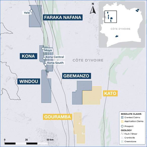
Figure 1: ABC Project Permit Areas
The MRE is over the Kona South and Kona Central deposits. The deposits are approximately 3km apart and are in the southern area of the Kona exploration permit.
The Moya prospect is located 8km north of Kona Central and represents a new growth target within the Kona permit.
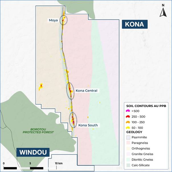
Figure 2: Prospect Areas
Drilling Program
Drilling at Kona commenced in February 2026 with the strategy to expand the mineralised footprint of the Kona South and Kona Central prospects. RC and diamond drilling has been undertaken to test the extensions of the mineralised zones to the north and south and down dip.
The programme was successful with economic intersections returned along strike at both Kona South and Kona Central, further demonstrating the continuity and growth potential of the mineralised system. Recent diamond drilling at Kona South also identified extensions to mineralisation at depth, highlighting additional opportunities to expand the resource footprint.
At Kona a total of 149 holes has been completed in 2026 comprised of 124 RC holes for 23,473m and 25 diamond drillholes for 7,645m.
Key Highlights
· KNRC0525: 53m @ 0.96 g/t Au from 86m
· KNRC0540: 9m @ 4.99 g/t Au from 19m
· KNRC0553: 41m @ 1.47 g/t Au from 269m
· KNRC0554: 66m @ 1.17 g/t Au from 165m
· KNRC0613: 66m @ 1.09 g/t Au from 176m
· KNRD0506: 30m @ 1.58 g/t Au from 231m
· KNRD0551: 33m @ 1.41 g/t Au from 120m
· KNRD0632: 24m @ 1.54 g/t Au from 236m
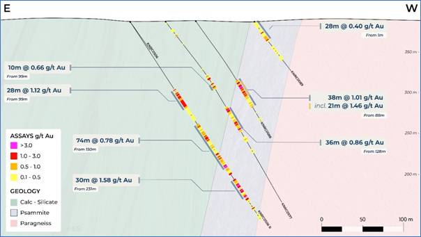
Figure 3: Kona South Cross Section at 966560N
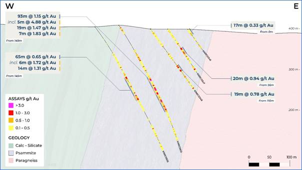
Figure 4: Kona Central Cross Section at 972750N
At Kona South, gold is predominantly hosted in psammitic units (north-south striking) dipping approximately 70° west. This unit is sandwiched between a calc-silicate hanging wall to the west and a paragneiss footwall to the east. An additional mafic volcanic unit lies west of the calc-silicate layer, completing the local stratigraphy.
The style of mineralisation is structurally controlled and shows a strong spatial association with arsenopyrite. Arsenopyrite occurs as disseminations and aggregates aligned with the foliation of the psammitic host. Strong silicification is evident within mineralised zones, though quartz veining is rare and does not appear to play a significant role in gold control.
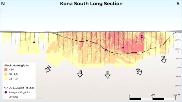
Figure 5: Kona South Long Section
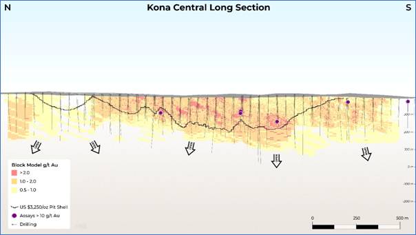
Figure 6: Kona Central Long Section
Moya
Located 8km north of Kona Central, Moya represents a new growth target within the Kona permit. Exploration drilling conducted alongside the broader Kona programmes has successfully identified gold mineralisation at Moya, highlighting its potential to expand the project's mineralised footprint and provide an additional source of future resource growth.
Key Highlights
· KNRC0442: 7m @ 1.80 g/t Au from 89m
· KNRC0449: 13m @ 2.21 g/t Au from 28m
· KNRC0461: 5m @ 4.23 g/t Au from 3m
· KNRD0624: 31m @ 0.95 g/t Au from 310m
· KNRD0624: 12.6m @ 1.04 g/t Au from 383m
Updated Mineral Resource Estimate
The updated Mineral Resource Estimate includes both Kona Central and Kona South deposits.
For Kona South, mineralisation was modelled as five discrete and stacked lodes, striking NNW and dipping steeply to the west. Wireframes were built using a lower domain cut-off grade of 0.2g/t and are mostly restricted to the mineralised Psammite unit. The overall modelled strike length is 2.5km with plan thickness of individual lodes up to 65m and a combined plan thickness of the mineralised zone up to 150m. The Kona South grade estimate used a wireframe constrained Ordinary Kriged ("OK") workflow.
Kona Central displays a broad mineralised zone with a modelled extent of 2.6km. Mineralisation strikes to the NNW and dips steeply west. The higher-grade zones within the overall broad envelope are less discrete than at Kona South. Therefore, a bulk zone wireframe was built to encapsulate all mineralised intercepts within the psammite units. Categorical Indicator Kriging (CIK) was applied within the bulk envelope to probabilistically define strongly and weakly mineralised sub-domains. Grade estimates were made into relatively large panel blocks using OK, and post processed through a non-linear Uniform Conditioning (UC) and Localised Uniform Conditioning (LUC) workflow. This method reproduces local grade variability and provides an indicative grade at the assumed eventual selective mining unit (SMU). Acknowledging that the LUC method can result in non-geological artifacts where conditioning data is sparse, a spatial filter was applied to ensure the LUC estimates are used only in areas closer to drill data, while deeper and more distal areas outside of the filter use the OK estimate.
The Mineral Resource for the ABC Project is constrained within an optimised pit shell assuming a gold price of US$3,250/oz and quoted above a cut-off of 0.3g/t (Table 1).
|
|
Constrained ABC Inferred Mineral Resource Estimate |
||
|
Prospect |
Mt |
Grade (g/t) |
Moz (Au) |
|
Kona Central |
64.6 |
0.62 |
1.29 |
|
Kona South |
68.1 |
0.79 |
1.72 |
|
Total |
132.7 |
0.71 |
3.02 |
Table 1: ABC Mineral Resource Estimate (at 0.3 g/t cut off, July 2026)
Notes:
· Mineral Resources are reported in accordance with the JORC Code 2012.
· Mineral Resources are reported at a cut-off grade of 0.3g/t Au.
· Mineral Resources are reported on a 100% basis.
· Mineral Resources have been reported within an optimised pit shell at US$3,250/oz Au
· Tonnes and ounces are rounded to reflect the precision of the estimate.
· Mineral Resources are not Ore Reserves and do not have demonstrated economic viability.
· No Ore Reserve has been declared for the ABC Gold Project.
· Updated MRE has an effective date of 12/07/2026
Summary of Kona Resource Parameters
A summary of JORC Table is provided at the end of the announcement for compliance regarding the Mineral Resources reported within and in-line with requirements of ASX Listing Rule 5.8.1.
Geology and Geological interpretation
The ABC project is situated along the main Archean-Birimian Cratonic suture zone in western Côte d'Ivoire, specifically associated with the Sassandra Fault Zone. The principal mineralised feature identified through mapping and sampling is the Lolosso structure, interpreted as a western splay off the major transcurrent Sassandra Fault.
The Kona mineralisation is predominantly hosted in psammitic units (NNW striking) dipping approximately 70° west. The psammites are sandwiched between a calc-silicate hanging wall to the west and a paragneiss footwall to the east.
At Kona South, mineralisation is modelled as five discrete and stacked lodes defining a corridor of combined plan thickness of up to 120m along a strike length of 2.5km. At Kona Central, mineralisation occurs in a broad zone, up to 240m wide, within which strongly and weakly mineralised sub domains are modelled.
Sampling and sub-sampling techniques
Reverse circulation samples were collected on 1m intervals by riffle split (dry) or by scoop (wet) to obtain a 1-3kg sample.
Diamond drill core has been systematically cut lengthwise into half core with a diamond saw were sampled by selecting half core.
Sample preparation includes oven drying, crushing to 10mm, splitting and pulverising to 85% passing - 75μm. These preparation techniques are deemed to be appropriate to the material being sampled.
Reverse circulation and core field duplicates were collected by the company at a rate of 1:20 samples.
Sampling, sample preparation and quality control protocols are of industry standard, and all attempts were made to ensure an unbiased representative sample was collected.
Drilling techniques
Drill types used include reverse circulation with face sampling bit and core drilling using HQ and NQ sized bits.
Classification criteria
Mineral Resources are classified in accordance with the Australasian Code for the Reporting of Exploration Results, Mineral Resources and Ore Reserves (JORC, 2012).
The deposit has been classified as Inferred Mineral Resource based on a combination of quantitative and qualitative criteria which include geologic continuity, confidence in volume models, data quality, sample spacing, lode continuity, and estimation parameters (number of informing composites, estimation pass number, kriging quality parameters, and minimum and average distance to composites).In addition, only material residing within the pit shells optimised assuming gold price of US$3,250/oz is included in the Mineral Resource.
The input data is consistent in its coverage of the modelled zones and does not favour or misrepresent the in-situ mineralisation. The definition of the mineralised zones is based on a moderate level of geologic understanding from good quality sample data. Validation of the block model shows good correlation of the input data to the block estimated grades. It is expected that infill drilling will enable conversion of portions of the Mineral Resources to higher confidence categories.
Sample analysis method
All samples were dispatched to MSA Yamoussoukro for sample preparation and gold analysis by Chrysos Photon Assay. The analytical method is considered appropriate for the style of mineralisation.
No geophysical tools were used to determine elemental concentrations.
Quality control (QC) procedures included the use of certified standards (1:40), non-certified sand blanks
(1:40) and reverse circulation/core field duplicates (1:20).
Laboratory quality control data, including laboratory standards, blanks, duplicates, repeats, grind size results and sample weights were also captured into the digital database.
Analysis of the QC sample assay results indicates that an acceptable level of accuracy and precision has been achieved.
Basis for selected cut-off grade
The cut-off grade of 0.3g/t is deemed to reflect the likely lower stockpiled grade for an open pit operation suited to the eventual mining of the Kona Mineral Resource. This is supported by preliminary scoping level studies into the Project potential.
Mining and metallurgical methods and other material modifying factors
Basic metallurgical testwork has been performed with more extensive investigations planned for future sampling campaigns. No mining modifying factors are yet applied to the MRE.
Next Phase of Work
Resolute has approved the next phase of work to advance ABC through feasibility studies. This is expected to cost $15-25 million over the next twelve to eighteen months. The work programme includes further infill and extension drilling, technical studies, environmental and social baseline work and metallurgical testwork. Key workstreams include:
Extensive Drill Programme
Resolute is ramping up drilling activity across the ABC Project, with at least 80,000m of drilling to expand the resource further and convert Inferred Mineral Resources into the Indicated category. There are currently 7 rigs onsite at Kona increasing to 11 rigs in August. This is to accelerate the drill programme which is planned to be completed by the end of 2026.
Preliminary drilling at Moya was successful in identifying potential economic mineralisation in the prospective horizon and follow up RC and diamond drilling is planned to be completed in H2 2026.
On the northern end of the Windou permit surface geochemistry has outlined an untested strong gold anomaly. This is planned to be drill tested in H2 2026.
Metallurgical testwork
A comprehensive metallurgical testwork programme is being initiated to improve understanding of ore characteristics and optimise the processing flowsheet. The programme will include additional comminution, gravity, leach, recovery and variability testwork across the Kona Central and Kona South deposits.
Results will be used to refine recovery assumptions, reagent consumption, process design criteria and operating cost estimates for future study phases
Permitting and Approvals
In H2 2026 early work will commence on the Environmental and Social Impact Assessment (ESIA) as well as land access and environmental approvals.
ESIA workstreams include environmental baseline studies, social baseline studies, stakeholder engagement, land access planning and permitting-related activities. The early commencement of the ESIA reflects Resolute's commitment to responsible project development and proactive engagement with local communities, government stakeholders and regulators.
Camp and Site Infrastructure
Resolute is progressing upgrades to the ABC exploration camp to support the expanded field programme and increased site activity. Planned works include accommodation, communications, core handling, sample preparation areas, power, water and general site logistics.
Contact
|
Resolute Matty O'Toole-Howes motoolehowes@resolutemining.com
|
Public Relations Jos Simson, Tavistock +44 207 920 3150
Corporate Brokers Jennifer Lee, Berenberg +44 20 3753 3040
Tom Rider, BMO Capital Markets +44 20 7236 1010 |
Authorised by Mr Chris Eger, Managing Director and Chief Executive Officer
About Resolute Mining
Resolute is an African-focused gold miner with more than 30 years of experience as an explorer, developer and operator. Throughout its history the Company has produced more than 9 million ounces of gold from ten gold mines. The Company is now entering a growth phase through the development of the Doropo project in Côte d'Ivoire which will supplement the existing production from the Syama mine in Mali and Mako mine in Senegal. The Company trades on the Australian Securities Exchange (ASX) and the London Stock Exchange (LSE) under the ticker RSG.
Competent Persons Statement
The information in this report that relates to the Exploration Results is based on information compiled by Mr Bruce Mowat, a member of The Australian Institute of Geoscientists. Mr Bruce Mowat has more than 20 years' experience relevant to the styles of mineralisation and type of deposit under consideration and to the activity which he is undertaking to qualify as a Competent Person, as defined in the 2012 Edition of the "Australasian Code for Reporting of Exploration Results, Mineral Resources and Ore Reserves" (the JORC Code). Mr Bruce Mowat is a full-time employee of the Resolute Mining Limited Group and holds equity securities in the Company. He has consented to the inclusion of the matters in this report based on his information in the form and context in which it appears. This information was prepared and disclosed under the JORC Code 2012 except where otherwise noted.
The information in this announcement that relates to the Mineral Resource estimate has been based on information and supporting documents prepared by Mr James Woodward, a Competent Person who is a member of The Australasian Institute of Mining and Metallurgy. Mr Woodward is a full-time employee of Resolute Mining Limited Group and has sufficient experience relevant to the style of mineralisation and type of deposit under consideration and to the activity which has been undertaken to qualify as a Competent Person. Mr Woodward confirms that the Mineral Resource estimate is based on information in the supporting documents and consents to the inclusion in the report of the Mineral Resource estimate and related content based on the information in the form and context in which it appears.
Cautionary Statement about Forward-Looking Statements
This announcement contains certain "forward-looking statements" including statements regarding our intent, belief or current expectations with respect to Resolute's business and operations, market conditions, results of operations and financial condition, and risk management practices. The words "likely", "expect", "aim", "should", "could", "may", "anticipate", "predict", "believe", "plan", "forecast" and other similar expressions are intended to identify forward-looking statements. Indications of, and guidance on, future earnings, anticipated production, life of mine and financial position and performance are also forward-looking statements. These forward-looking statements involve known and unknown risks, uncertainties and other factors that may cause Resolute's actual results, performance and achievements or industry results to differ materially from any future results, performance or achievements, or industry results, expressed or implied by these forward-looking statements. Relevant factors may include (but are not limited to) changes in commodity prices, foreign exchange fluctuations and general economic conditions, increased costs and demand for production inputs, the speculative nature of exploration and project development, including the risks of obtaining necessary licences and permits and diminishing quantities or grades of reserves, political and social risks, changes to the regulatory framework within which Resolute operates or may in the future operate, environmental conditions including extreme weather conditions, recruitment and retention of personnel, industrial relations issues and litigation.
Forward-looking statements are based on Resolute's good faith assumptions as to the financial, market, regulatory and other relevant environments that will exist and affect Resolute's business and operations in the future. Resolute does not give any assurance that the assumptions will prove to be correct. There may be other factors that could cause actual results or events not to be as anticipated, and many events are beyond the reasonable control of Resolute. Readers are cautioned not to place undue reliance on forward-looking statements, particularly in the current economic climate with the significant volatility, uncertainty and disruption caused by the COVID-19 pandemic. Forward-looking statements in this document speak only at the date of issue. Except as required by applicable laws or regulations, Resolute does not undertake any obligation to publicly update or revise any of the forward-looking statements or to advise of any change in assumptions on which any such statement is based. Except for statutory liability which cannot be excluded, each of Resolute, its officers, employees and advisors expressly disclaim any responsibility for the accuracy or completeness of the material contained in these forward-looking statements and excludes all liability whatsoever (including in negligence) for any loss or damage which may be suffered by any person as a consequence of any information in forward-looking statements or any error or omission.
Appendix 1: Recent drilling Results at Kona
|
HoleID |
East_WGS |
North_WGS |
RL |
EOH |
Azi_WGS |
DIP |
From |
To |
Width |
Au ppm |
|
KNRC0499 |
678179 |
968084 |
383 |
115 |
90 |
-55 |
40 |
53 |
13 |
1.754 |
|
KNRC0501 |
678455 |
966373 |
391 |
82 |
90 |
-55 |
8 |
29 |
21 |
1.048 |
|
KNRC0520 |
678186 |
967727 |
383 |
150 |
86.4 |
-55 |
100 |
125 |
25 |
0.871 |
|
KNRC0521 |
678108 |
967726 |
383 |
228 |
91.3 |
-55 |
143 |
169 |
26 |
1.173 |
|
KNRC0522 |
678189 |
967826 |
379 |
140 |
86.4 |
-55 |
30 |
65 |
35 |
0.888 |
|
KNRC0524 |
678191 |
967930 |
379 |
125 |
91.3 |
-55 |
2 |
29 |
27 |
0.801 |
|
KNRC0524 |
678191 |
967930 |
379 |
125 |
91.3 |
-55 |
33 |
73 |
40 |
0.768 |
|
KNRC0525 |
678115 |
967929 |
381 |
223 |
91.3 |
-55 |
86 |
139 |
53 |
0.962 |
|
KNRC0537 |
678457 |
966419 |
390 |
90 |
90 |
-55 |
7 |
33 |
26 |
1.344 |
|
KNRC0540 |
677728 |
972193 |
393 |
288 |
91.3 |
-55 |
19 |
28 |
9 |
4.994 |
|
KNRC0541 |
677730 |
972240 |
393 |
282 |
91.3 |
-55 |
164 |
203 |
39 |
0.802 |
|
KNRC0547 |
677772 |
972397 |
404 |
200 |
90 |
-55 |
166 |
188 |
22 |
1.131 |
|
KNRC0553 |
677628 |
972647 |
405 |
342 |
90 |
-55 |
107 |
129 |
22 |
0.955 |
|
KNRC0553 |
677628 |
972647 |
405 |
342 |
90 |
-55 |
269 |
310 |
41 |
1.465 |
|
KNRC0554 |
677685 |
972699 |
409 |
276 |
90 |
-55 |
103 |
134 |
31 |
0.788 |
|
KNRC0554 |
677685 |
972699 |
409 |
276 |
90 |
-55 |
165 |
231 |
66 |
1.168 |
|
KNRC0556 |
677616 |
972847 |
399 |
318 |
90 |
-55 |
97 |
118 |
21 |
1.365 |
|
KNRC0556 |
677616 |
972847 |
399 |
318 |
90 |
-55 |
177 |
196 |
19 |
1.167 |
|
KNRC0558 |
677654 |
972948 |
395 |
230 |
90 |
-55 |
29 |
49 |
20 |
1.28 |
|
KNRC0558 |
677654 |
972948 |
395 |
230 |
90 |
-55 |
117 |
142 |
25 |
0.827 |
|
KNRC0562 |
677545 |
973552 |
412 |
258 |
90 |
-55 |
80 |
103 |
23 |
1.07 |
|
KNRC0567 |
677566 |
973746 |
416 |
156 |
90 |
-55 |
0 |
9 |
9 |
2.55 |
|
KNRC0572 |
677548 |
973993 |
420 |
115 |
91.3 |
-55 |
18 |
42 |
24 |
1.111 |
|
KNRC0573 |
677498 |
973993 |
419 |
195 |
91.3 |
-55 |
45 |
62 |
17 |
1.33 |
|
KNRC0583 |
677738 |
972499 |
412 |
276 |
90 |
-55 |
205 |
235 |
30 |
1.123 |
|
KNRC0613 |
677669 |
972753 |
407 |
318 |
91.4 |
-55 |
145 |
158 |
13 |
2.245 |
|
KNRC0613 |
677669 |
972753 |
407 |
318 |
91.4 |
-55 |
176 |
242 |
66 |
1.092 |
|
KNRC0621 |
677639 |
972497 |
402 |
266 |
90 |
-55 |
130 |
147 |
17 |
1.581 |
|
KNRC0621 |
677639 |
972497 |
402 |
266 |
90 |
-55 |
153 |
177 |
24 |
1.023 |
|
KNRC0625 |
678169 |
967662 |
385 |
200 |
91 |
-55 |
48 |
67 |
19 |
1.93 |
|
KNRC0633R |
678196 |
966919 |
390 |
365 |
91.4 |
0 |
253 |
278 |
25 |
1.729 |
|
KNRD0506R |
678308 |
966560 |
386 |
290.1 |
90 |
-55 |
99 |
126 |
27 |
1.142 |
|
KNRD0506R |
678308 |
966560 |
386 |
290.1 |
90 |
-55 |
150 |
175 |
25 |
0.84 |
|
KNRD0506R |
678308 |
966560 |
386 |
290.1 |
90 |
-55 |
193 |
218 |
25 |
1.07 |
|
KNRD0506R |
678308 |
966560 |
386 |
290.1 |
90 |
-55 |
231.1 |
261 |
29.9 |
1.576 |
|
KNRD0512 |
678142 |
967472 |
387 |
266.1 |
90 |
-55 |
169 |
184 |
15 |
1.439 |
|
KNRD0549 |
677687 |
972502 |
403 |
296.2 |
90 |
-55 |
138 |
164 |
26 |
0.816 |
|
KNRD0549 |
677687 |
972502 |
403 |
296.2 |
90 |
-55 |
233 |
261 |
28 |
0.905 |
|
KNRD0551 |
677680 |
972549 |
404 |
290.2 |
90 |
-55 |
120 |
153 |
33 |
1.405 |
|
KNRD0551 |
677680 |
972549 |
404 |
290.2 |
90 |
-55 |
226.5 |
257 |
30.5 |
0.91 |
|
KNRD0579R |
678167 |
966763 |
389 |
349.8 |
90 |
-55 |
328 |
348 |
20 |
1.4 |
|
KNRD0622 |
678189 |
966966 |
370 |
351 |
91.4 |
-55 |
288 |
321 |
33 |
1.235 |
|
KNRD0632 |
678201 |
967064 |
390 |
320.1 |
91.4 |
-55 |
236 |
260 |
24 |
1.54 |
|
KNRD0632 |
678201 |
967064 |
390 |
320.1 |
91.4 |
-55 |
291 |
318 |
27 |
2.237 |
Recent drilling Results at Moya
|
HoleID |
East_WGS |
North_WGS |
RL_WGS |
EOH |
Azi_WGS |
DIP |
From |
To |
Width |
Au ppm |
|
KNRC0442 |
676252.920 |
986737.628 |
386.368 |
114 |
90 |
-55 |
89 |
96 |
7 |
1.795 |
|
KNRC0449 |
676442.906 |
987401.622 |
381.465 |
54 |
90 |
-55 |
28 |
41 |
13 |
2.206 |
|
KNRC0461 |
676582.874 |
987900.004 |
391.159 |
54 |
90 |
-55 |
3 |
8 |
5 |
4.228 |
|
KNRD0624 |
678110.535 |
967018.811 |
390.501 |
396 |
90 |
-55 |
310 |
341 |
31 |
0.952 |
|
KNRD0624 |
678110.535 |
967018.811 |
390.501 |
396 |
90 |
-55 |
383 |
396 |
13 |
1.042 |
Notes to Accompany Table:
• Grid coordinates are WGS84 Zone 29 North
• RC intervals are sampled every 1m by dry riffle splitting or scoop to provide a 2-3kg sample
• Diamond core are sampled every 1m by cutting the core in half to provide a 2-4kg sample
• Cut-off grade for reporting of intercepts is >0.5g/t Au with a maximum of 3m consecutive internal dilution included within the intercept; only intercepts >=3m and >20 gram x metres are reported
• Recent drill samples are analysed for gold by MSA Labs CPA-Au1 500g sample gamma ray analysis by photon assay instrument whilst prior drill programs included fire assay aas techniques
Comparison with previous Mineral Resource Estimate
The table below shows the global unconstrained Mineral Resource Estimate from the historical 2021 MRE and the updated MRE in this announcement. At a 0.5 g/t cut off the MRE has increased by approximately 31%.
|
|
Global ABC Mineral Resource Estimate |
|||||
|
|
July 2021 (0.5g/t Au cut-off) |
July 2026 (0.5g/t Au cut-off) |
||||
|
Classification |
Mt |
Grade (g/t Au) |
Moz (Au) |
Tonnes |
Grade (g/t Au) |
Moz (Au) |
|
Inferred |
72 |
0.93 |
2.16 |
101 |
0.87 |
2.83 |
|
Total |
72 |
0.93 |
2.16 |
101 |
0.87 |
2.83 |
Table 2: ABC Mineral Resource Estimate Comparison (Unconstrained)
JORC Code, 2012 Edition
Additional technical information relating to foreign estimates ASX Listing Rule 5.12
ABC Project - Mineral Resource Estimate (July 2026)
Section 1 Sampling Techniques and Data
(Criteria in this section apply to all succeeding sections.)
|
Criteria |
JORC Code explanation |
Commentary |
|
Sampling techniques |
Nature and quality of sampling (eg cut channels, random chips, or specific specialised industry standard measurement tools appropriate to the minerals under investigation, such as down hole gamma sondes, or handheld XRF instruments, etc). These examples should not be taken as limiting the broad meaning of sampling. Include reference to measures taken to ensure sample representivity and the appropriate calibration of any measurement tools or systems used. Aspects of the determination of mineralisation that are Material to the Public Report. In cases where 'industry standard' work has been done this would be relatively simple (eg 'reverse circulation drilling was used to obtain 1 m samples from which 3 kg was pulverised to produce a 30 g charge for fire assay'). In other cases more explanation may be required, such as where there is coarse gold that has inherent sampling problems. Unusual commodities or mineralisation types (eg submarine nodules) may warrant disclosure of detailed information. |
The sampling was conducted using multiple techniques tailored to the project's geological and surface conditions. A systematic rock sampling programme was caried out in 2017 to fully characterise the surface expression of the mineralisation. A total of 788 rock samples were collected in 2017 and 205 rock samples in 2019/2020. Auger drilling was employed extensively over the mineralised corridor to adequately characterise the underlying rocks. Auger drilling recovered material systematically for gold analysis and geochemical interpretation. As with the rock chips, auger samples were analysed for Au by fire assay with AAS finish at Bureau Veritas in Abidjan. Multi-element analyses were completed by four-acid digest with ICP-AES and ICP-MS finish at ACME Laboratories in Vancouver. A total of 2,843 samples were collected at the end of 2020 from 22,219m drilled. Reverse Circulation (RC) and Diamond Core (DD) drilling were the principal methods used for delineating Mineral Resources. RC drilling was used 5¼ to 5¾ inch diameter face-sampling hammers to recover one-metre interval samples, typically dry unless groundwater was encountered. Diamond drilling employed HQ and NQ diameter core, with triple tube techniques for improving recovery in broken ground. RC samples were riffle split on site, and core samples were sawn to produce half-core for analysis. Sampling procedures incorporated QAQC measures, including the insertion of blanks, standards, and duplicates to ensure sample representivity. Assay protocols utilised 50 g fire assay (AAS finish) for gold, and multi-element analysis was performed where applicable. |
|
Drilling techniques |
Drill type (eg core, reverse circulation, open-hole hammer, rotary air blast, auger, Bangka, sonic, etc) and details (eg core diameter, triple or standard tube, depth of diamond tails, face-sampling bit or other type, whether core is oriented and if so, by what method, etc). |
Drilling methods involved a combination of Reverse Circulation (RC), Diamond Core (DD), and auger drilling methods. RC drilling was primarily used for delineating near-surface mineralisation and preliminary resource definition. RC drilling employed face-sampling hammers with bit sizes ranging from 5¼ to 5¾ inches. Dry drilling was the standard procedure, with drilling halted at the water table to prevent contamination from wet samples; below groundwater, diamond drilling methods were applied. Diamond core drilling used HQ and NQ diameter core. Triple-tube systems were implemented in highly broken ground to maximise core recovery, while standard double-tube setups were used elsewhere. Downhole surveys are taken every 30m with a single shot Reflex EZ shot system. Orientation of diamond core was conducted selectively using Reflex ACT II core orientation devices to facilitate structural logging. Auger drilling was utilised for shallow exploration across the entire area. All drill methods were executed to a high standard with contractors experienced in gold exploration in West Africa. |
|
Drill sample recovery |
Method of recording and assessing core and chip sample recoveries and results assessed. Measures taken to maximise sample recovery and ensure representative nature of the samples. Whether a relationship exists between sample recovery and grade and whether sample bias may have occurred due to preferential loss/gain of fine/coarse material. |
Drill sample recovery was systematically monitored during both RC and diamond drilling programs. RC samples were weighed regularly, to monitor sample size consistency and ensure the representativeness of samples. Analysis of sample weights of 47,562 RC samples from Kona South and 47,464 RC samples showed a consistent recovery trend stabilizing between 30-40 kg per metre after clearing the uppermost weathered horizons. Minor variations in sample weight were observed at shallow depths and in softer materials; however, statistical checks confirmed no significant bias in gold grade associated with sample mass. Diamond core recovery was measured, with an overall average recovery of approximately 96% across the project. Recovery rates improved with depth, with 81% core recovery in oxide, 91% recovery in transitional and 99% in fresh. Core recovery measurements were recorded in the database for each run. The use of triple-tube drilling in broken ground contributed to maintaining high recovery standards. The overall conclusion, supported by quality control reviews, was that there is no significant sampling bias attributable to differential recovery |
|
Logging |
Whether core and chip samples have been geologically and geotechnically logged to a level of detail to support appropriate Mineral Resource estimation, mining studies and metallurgical studies. Whether logging is qualitative or quantitative in nature. Core (or costean, channel, etc) photography. The total length and percentage of the relevant intersections logged. |
Comprehensive geological and geotechnical logging was undertaken for all drillholes including RC and DD. Drillholes were logged systematically for a range of key geological attributes: lithology, alteration, mineralisation, texture, structure, weathering, and rock quality designation (RQD). RC samples were logged visually on site, with geological observations recorded both digitally and on physical log sheets where applicable. Diamond core was logged in greater detail, particularly for structural geology, alteration styles, mineral assemblages, and vein relationships, providing critical inputs for 3D geological modelling. • Photographic records were maintained for all diamond drill core - photographed both wet and dry - before sampling. Logging captured sufficient detail to support resource estimation, mining studies, and metallurgical investigations. Logging procedures included the use of a standardised lithological and alteration coding scheme to ensure consistency across the drilling campaigns. Digital capture of logging data into a centralised database with validation rules also enhanced data reliability. |
|
Sub-sampling techniques and sample preparation |
If core, whether cut or sawn and whether quarter, half or all core taken. If non-core, whether riffled, tube sampled, rotary split, etc and whether sampled wet or dry. For all sample types, the nature, quality and appropriateness of the sample preparation technique. Quality control procedures adopted for all sub-sampling stages to maximise representivity of samples. Measures taken to ensure that the sampling is representative of the in situ material collected, including for instance results for field duplicate/second-half sampling. Whether sample sizes are appropriate to the grain size of the material being sampled. |
Systematic sub-sampling and sample preparation protocols were employed to ensure that samples remained representative of in situ mineralisation. For RC drilling, 1 m samples were split on site using a three-tier riffle splitter to achieve a target sample size of approximately 2 to 3 kg for laboratory submission. Wet samples encountered in shallow zones were left to dry naturally prior to splitting where possible. For diamond drilling, core was cut lengthwise using diamond-bladed core saws; half-core samples were collected for routine assay, while the other half was preserved for reference and potential future re-assay. Sample preparation at the laboratory followed industry best practices. Samples were oven dried, crushed to 70 to 85% passing 2 mm, then riffle split to produce a subsample for pulverisation. The pulverised material was milled to achieve at least 85% passing 75 microns, producing a pulp of approximately 150 to 250 g for fire assay analysis. Quality assurance measures were built into preparation workflows, including the regular inclusion of duplicate splits and check samples. Laboratory facilities used (primarily Bureau Veritas Abidjan, SGS Ouagadougou) operated to ISO 17025 standards, and internal laboratory QAQC reviews were conducted regularly. More recent Au analyses were conducted by Chrysos Photon assay at MSA labs in Yamoussoukro. Laboratory and assay procedures are appropriate for Mineral Resource estimation |
|
Quality of assay data and laboratory tests |
The nature, quality and appropriateness of the assaying and laboratory procedures used and whether the technique is considered partial or total. For geophysical tools, spectrometers, handheld XRF instruments, etc, the parameters used in determining the analysis including instrument make and model, reading times, calibrations factors applied and their derivation, etc. Nature of quality control procedures adopted (eg standards, blanks, duplicates, external laboratory checks) and whether acceptable levels of accuracy (ie lack of bias) and precision have been established. |
Assay methodologies were based on internationally recognised standards and utilised reputable laboratories. All drill samples were primarily analysed for gold using 50 g fire assay with atomic absorption spectroscopy (AAS) or inductively coupled plasma atomic emission spectroscopy (ICP-AES) finish. In cases where assays exceeded 10 g/t Au, samples were re-analysed using a gravimetric finish to improve accuracy. For some RC and trench samples, particularly those with coarse gold. Quality control procedures were rigorous. Certified reference materials (standards), field blanks, and field duplicates were inserted into the sample stream at regular intervals - approximately one QAQC sample every 20 to 30 samples. Laboratory duplicates, internal standards, and blanks were also monitored. QAQC data were routinely reviewed to ensure analytical accuracy and precision. Failures (e.g., a standard outside 3 standard deviations) triggered immediate re-assay of sample batches. No significant long-term bias or drift was observed across the assay dataset. Laboratories involved (Bureau Veritas, Abidjan and SGS, Ouagadougou) are ISO/IEC 17025 accredited, ensuring laboratory practices are consistent with industry best practice. |
|
Verification of sampling and assaying |
The verification of significant intersections by either independent or alternative company personnel. The use of twinned holes. Documentation of primary data, data entry procedures, data verification, data storage (physical and electronic) protocols. Discuss any adjustment to assay data. |
Verification of sampling and assaying was undertaken through a combination of internal reviews, duplicate analyses, and independent data validation exercises. Field duplicates were collected regularly from RC drilling to monitor sampling precision, with results demonstrating satisfactory repeatability of gold grades. CRMs and blanks were inserted at regular intervals to monitor assay accuracy and contamination. QAQC charts were reviewed continuously by project geologists and external consultants during key drilling campaigns.
• The primary assay laboratories (Bureau Veritas and SGS) conducted their own internal QC programs, which were also monitored. Limited twin drilling was conducted, with twin RC holes and DD holes used to verify mineralisation continuity, grade reproducibility, and geological interpretation; results confirmed good spatial reproducibility. While external umpire (secondary lab) assay programs were not routinely undertaken, the performance of primary laboratories and internal QAQC programs were considered satisfactory for the reporting of Mineral Resources. Assay data and logging data were entered digitally into validated databases, and independent audits of the database have been performed during resource estimation reviews. |
|
Location of data points |
Accuracy and quality of surveys used to locate drill holes (collar and down-hole surveys), trenches, mine workings and other locations used in Mineral Resource estimation. Specification of the grid system used. Quality and adequacy of topographic control. |
Drillhole collar locations were surveyed using a combination of differential GPS (DGPS) systems and total station surveying where higher precision was required. The DGPS surveys were conducted by trained field surveyors to ensure location accuracy suitable for Mineral Resource estimation, with horizontal and vertical accuracy generally within ±0.2 m. In areas of rugged topography or logistical difficulty, survey-grade handheld GPS units were temporarily used during initial exploration stages (rock sampling, auger drilling), but were later replaced with DGPS surveys for all critical drill collars. Elevation data were tied into the Nivellement Général de Côte d'Ivoire (NGCI) vertical datum. A topographic digital terrain model (DTM) was produced using high-resolution satellite imagery and ground-truthing, which was used for resource modelling. Grid systems used were WGS84, Zone 29N for initial exploration and UTM Zone 29N (WGS84 projection) for final resource definition. |
|
Data spacing and distribution |
Data spacing for reporting of Exploration Results. Whether the data spacing and distribution is sufficient to establish the degree of geological and grade continuity appropriate for the Mineral Resource and Ore Reserve estimation procedure(s) and classifications applied. Whether sample compositing has been applied. |
Drilling was conducted on nominal grid spacings appropriate for the level of confidence required for resource estimation. In the main mineralised zones at Kona South and Kona Central RC and diamond drilling was performed on approximately 50 m x 50 m grids with some areas of wider spacing of 50m x 100m. Outside the main resource areas, reconnaissance and exploration drilling was more broadly spaced at 50 m x 200 m intervals, appropriate for early-stage resource targeting. Data spacing was assessed during Mineral Resource Estimation and was found sufficient to establish geological and grade continuity for inferred classification. No sample compositing was applied prior to resource estimation; raw assay intervals were used directly in estimation procedures. |
|
Orientation of data in relation to geological structure |
Whether the orientation of sampling achieves unbiased sampling of possible structures and the extent to which this is known, considering the deposit type. If the relationship between the drilling orientation and the orientation of key mineralised structures is considered to have introduced a sampling bias, this should be assessed and reported if material. |
Drilling programs were designed to target mineralised structures as close to perpendicular as possible to the interpreted dip of mineralisation at each deposit. All drillholes were oriented towards the east with an inclination of - 50° to -60°, depending on the local structural orientation of gold-bearing zones. The mineralisation is generally hosted in north trending structures dipping moderately to steeply to the west, making these drill orientations appropriate to intersect mineralised zones at reasonable angles and to minimise bias in the intercept lengths. Geological interpretations and cross sections confirm that drilling achieved reasonably representative intersections of mineralisation. No significant sampling bias related to drilling orientation was observed during resource modelling and estimation. |
|
Sample security |
The measures taken to ensure sample security. |
Sample security protocols were implemented to ensure the integrity of all collected samples from the point of collection through to laboratory delivery. After collection, samples were placed into pre-numbered, durable plastic bags and securely sealed. Multiple samples were then packed into larger polyweave sacks for easier handling and protection during transport. Samples were stored in a secure, supervised facility at the exploration camp before transportation. Transport to the assay laboratories (Bureau Veritas in Abidjan and SGS in Ouagadougou) was carried out either by company personnel or trusted, contracted couriers. Chain-of-custody forms were maintained throughout the transfer process, and receipt of samples was acknowledged in writing by laboratory staff. While rigorous internal controls were observed, there is no specific mention of external audits or independent oversight of sample security protocols. However, no incidents of sample loss, tampering, or contamination have been reported, and laboratory reconciliation of received samples consistently matched dispatch records. |
|
Audits or reviews |
The results of any audits or reviews of sampling techniques and data. |
Audits and reviews of sampling techniques, assay data, and database integrity have been carried out periodically. Internal technical reviews were performed by Resolute's in-house geology and resource teams throughout the exploration and resource evaluation phases. These reviews covered sampling practices, QAQC data performance, logging standards, and database quality, ensuring consistent application of protocols and identifying areas for procedural improvement where necessary. • Independent reviews of the Resource models and supporting exploration data were conducted as part of the NI 43-101 technical report preparation. Qualified Persons (QPs) signed off on the Mineral Resource estimates after assessing the drilling, sampling, and QAQC procedures. |
Section 2 Reporting of Exploration Results
(Criteria listed in the preceding section also apply to this section.)
|
Criteria |
JORC Code explanation |
Commentary |
|
Mineral tenement and land tenure status |
Type, reference name/number, location and ownership including agreements or material issues with third parties such as joint ventures, partnerships, overriding royalties, native title interests, historical sites, wilderness or national park and environmental settings. The security of the tenure held at the time of reporting along with any known impediments to obtaining a licence to operate in the area. |
•The Kona South and Kona Central deposits are the most advanced prospects in Resolute's ABC Project, which is located in the Kabadougou Region of the Denguélé District, in the northwest of Cote D'Ivoire. The Kona permit occurs approximately 600 km west of Resolute's Doropo Project and 540 km north-west of the capital city of Abidjan. The Kona permit is 100% owned by Centamin Cote d'Ivoire SARL, which is a 100% owned Ivoirian subsidiary of Resolute and covers an area of 382.9 km2 All permits (Kona PR658, Windou PR877 and Farako Nafana) are held in good standing with the Côte d'Ivoire Ministry of Mines and have been maintained in accordance with local legal requirements. There are no known outstanding disputes affecting the licences and no known risks or environmental liabilities that could adversely affect or result in the loss of ownership of the Resource or permits. |
|
Exploration done by other parties |
Acknowledgment and appraisal of exploration by other parties. |
Newmont are believed to be the first exploration company to explore the area in 2010. They conducted regional drainage sampling, mapping and prospecting across the entire district. This work highlighted the Kona area as one of their highest ranked targets. Local exploration companies, including Golden Oriole and Sani Resources, applied for exploration permits on the back of the Newmont reconnaissance licences but never raised the finance to conduct any significant work and subsequently had their permits revoked. Centamin acquired the exploration permits from the government in 2015 to 2016. The 2018 Kona South Mineral Resource is the first defined in the area. There is no evidence of any illegal artisanal mining in the permit area. |
|
Geology |
Deposit type, geological setting and style of mineralisation. |
The ABC project is situated along the main Archean-Birimian Cratonic suture zone in western Côte d'Ivoire, specifically associated with the Sassandra Fault Zone. The principal mineralised feature identified through mapping and sampling is the Lolosso structure, a north-south striking mineralised zone interpreted as a western splay off the major transcurrent Sassandra Fault. The geological setting includes a narrow keel of later Birimian volcano-sediments entrapped within earlier Archean thrusted granite and gneissic sheets, providing a complex structural and lithological host for mineralisation. At Kona South, gold is predominantly hosted in psammitic units (north-south striking) dipping approximately 70° west. This unit is sandwiched between a calc-silicate hanging wall to the west and a paragneiss footwall to the east. An additional mafic volcanic unit lies west of the calc-silicate layer, completing the local stratigraphy. The style of mineralisation is structurally controlled and shows a strong spatial association with arsenopyrite. Arsenopyrite occurs as disseminations and aggregates aligned with the foliation of the psammitic host. Strong silicification is evident within mineralised zones, though quartz veining is rare and does not appear to play a significant role in gold control. |
|
Drill hole Information |
A summary of all information material to the understanding of the exploration results including a tabulation of the following information for all Material drill holes: easting and northing of the drill hole collar elevation or RL (Reduced Level - elevation above sea level in metres) of the drill hole collar dip and azimuth of the hole down hole length and interception depth hole length. If the exclusion of this information is justified on the basis that the information is not Material and this exclusion does not detract from the understanding of the report, the Competent Person should clearly explain why this is the case. |
The NI 43-101 Technical Report provides comprehensive drillhole information, covering collar locations, drill hole depths, azimuths, dips, and key intersections. Drillhole collars were initially surveyed using a handheld GPS, then independently surveyed using differential GPS (DGPS) or total station equipment. The collars are in the UTM Zone 29 North, WGS84 datum. The QP considered a drill plan and representative examples of drill sections through Kona South and Kona Central would be more informative than a tabulation of mineralised intercepts. Sections are provided in the report. The database includes 828 drillholes for a total of 114,371m of drilling. |
|
Data aggregation methods |
In reporting Exploration Results, weighting averaging techniques, maximum and/or minimum grade truncations (eg cutting of high grades) and cut-off grades are usually Material and should be stated. Where aggregate intercepts incorporate short lengths of high grade results and longer lengths of low grade results, the procedure used for such aggregation should be stated and some typical examples of such aggregations should be shown in detail. The assumptions used for any reporting of metal equivalent values should be clearly stated. |
Exploration results and Mineral Resource drill intercepts are reported based on compositing of contiguous mineralised intervals. Assay results were composited to 1m to ensure that sample length variability did not introduce bias. The average sample interval is 0.998m. No metal equivalent values have been reported. No top-cutting (grade capping) was applied when presenting raw exploration results; however, top- cutting was considered and applied during Mineral Resource estimation to control the influence of extreme outlier grades. Composites used downhole lengths of 1 m, reflecting the RC and DD sampling intervals. |
|
Relationship between mineralisation widths and intercept lengths |
These relationships are particularly important in the reporting of Exploration Results. If the geometry of the mineralisation with respect to the drill hole angle is known, its nature should be reported. If it is not known and only the down hole lengths are reported, there should be a clear statement to this effect (eg 'down hole length, true width not known'). |
The ABC Project drilling programme was designed to optimise intersection angles relative to the interpreted orientation of gold mineralisation. Mineralisation typically occurs within steeply dipping shear zones striking north - south, dipping steeply ~70⁰ to the west. To account for this geometry, most drillholes were inclined at approximately -55° to -60° and drilled toward the east. This does result in intersections of the mineralisation at a high angle, and in general, true thickness is 80% of the sample length. |
|
Diagrams |
Appropriate maps and sections (with scales) and tabulations of intercepts should be included for any significant discovery being reported These should include, but not be limited to a plan view of drill hole collar locations and appropriate sectional views. |
The NI 43-101 Technical Report provides a variety of diagrams that illustrate the distribution of mineralisation, drill coverage and geological interpretation. These include: Plan view maps showing drill hole collar locations and surface projections of the mineralised zones. Cross sections and long sections through the deposits depicting lithological units, interpreted mineralisation wireframes, and drill intercepts. Regional geological maps. |
|
Balanced reporting |
Where comprehensive reporting of all Exploration Results is not practicable, representative reporting of both low and high grades and/or widths should be practiced to avoid misleading reporting of Exploration Results. |
Exploration results are presented in a manner that is consistent with balanced reporting principles. Both positive results (significant gold intersections) and lower-grade or barren drilling outcomes are discussed in the report narrative. Resource estimation was based on all available drilling data, not just high-grade intervals. |
|
Other substantive exploration data |
Other exploration data, if meaningful and material, should be reported including (but not limited to): geological observations; geophysical survey results; geochemical survey results; bulk samples - size and method of treatment; metallurgical test results; bulk density, groundwater, geotechnical and rock characteristics; potential deleterious or contaminating substances. |
The ABC project has benefited from a broad range of exploration activities in addition to drilling. Centamin and Resolute's exploration campaign included reconnaissance mapping and systematic rock chip sampling, auger sampling, ground geophysical survey, an airborne Magnetic and Radiometric survey as well as reverse circulation (RC) and diamond drilling. All the exploration work was conducted by Resolute personnel, or under their direct management, when carried out by contractors. Preliminary, metallurgical testwork has been carried out by Centamin, summarised in the report. Bulk densities have been measured from drill core. There are no known deleterious elements. |
|
Further work |
The nature and scale of planned further work (eg tests for lateral extensions or depth extensions or large-scale step-out drilling). Diagrams clearly highlighting the areas of possible extensions, including the main geological interpretations and future drilling areas, provided this information is not commercially sensitive. |
Further work has been identified to support future exploration, evaluation, and potential development. Recommended activities include additional infill and extensional drilling aimed at converting Inferred Resources to Indicated and Measured categories, as well as to test mineralised structures beyond the current limits of resource models. Trenching to test new soil anomalies to identify additional targets. More density testwork is required, specifically for the weathered portions of the Kona deposit to generate reliable density data. |
Section 3 Estimation and Reporting of Mineral Resources
(Criteria listed in section 1, and where relevant in section 2, also apply to this section.)
|
Criteria |
JORC Code explanation |
Commentary |
|
Database integrity |
Measures taken to ensure that data has not been corrupted by, for example, transcription or keying errors, between its initial collection and its use for Mineral Resource estimation purposes. Data validation procedures used. |
The drillhole database supporting the ABC Kona Resource estimate was subject to comprehensive data management processes employed by the site team. Validations are routinely performed on collar coordinates, downhole survey measurements, lithology logs, and assay entries to ensure consistency and accuracy. QA/QC protocols were applied throughout the data collection and entry stages. Only RC and DD were used for the Mineral Resource estimate. The CP ran validation checks on the drill hole data in addition to those employed at the Project site. No errors were found that would materially affect confidence in the database or the subsequent resource estimate. |
|
Site visits |
Comment on any site visits undertaken by the Competent Person and the outcome of those visits. If no site visits have been undertaken indicate why this is the case. |
The CP visited the ABC Project site in March 2026 and gained a comprehensive overview of the geology, facilities and processes related to collection and processing of data relevant to the MRE. The visit included inspection of representative drill core from both Kona Central and Kona South deposits, outcrops and active RC drill sites. |
|
Geological interpretation |
Confidence in (or conversely, the uncertainty of ) the geological interpretation of the mineral deposit. Nature of the data used and of any assumptions made. The effect, if any, of alternative interpretations on Mineral Resource estimation. The use of geology in guiding and controlling Mineral Resource estimation. The factors affecting continuity both of grade and geology. |
The geological interpretation is based on geological mapping, drilling data, assay results, and geophysical data. The project area is located along the main Archean-Birimian Cratonic suture zone, the Sassandra Fault zone and hosts structurally controlled gold mineralisation. The geological model interprets mineralised zones as steeply dipping shear-hosted lodes, which are consistent with regional structural trends observed in comparable deposits throughout the belt. Gold is hosted almost entirely in the north-south striking psammite unit, dipping approximately 70° to the west. This unit is sandwiched between a calc-silicate unit to the west (hanging wall) and a paragneiss unit to the east (footwall). A further mafic volcanic unit abuts the hanging wall calc-silicate to the west, completing the Birimian inlier stratigraphy. The interpretation of geology and mineralisation has been used to control the definition of wireframe solids for the mineralised wireframes, with mineralisation generally limited to the psammite units. Mineralisation wireframes were modelled in Leapfrog using the Vein Modelling workflow. Five mineralised lodes were modelled at Kona South using a lower cutoff grade of 0.2g/t gold. At Kona Central, a single bulk domain was modelled to capture all intercepts within the Psammite zone. Sub domains were then defined through categorical indicator kriging using a lower threshold of 0.2 g/t gold. |
|
Criteria |
JORC Code explanation |
Commentary |
|
Dimensions |
The extent and variability of the Mineral Resource expressed as length (along strike or otherwise), plan width, and depth below surface to the upper and lower limits of the Mineral Resource. |
The Kona South Mineral Resource has a strike length of 2.5km trending towards NNW with a steep dip of 70⁰ towards the west. The major domains have a maximum extension down dip of approximately 400 m to 0 mRL. The Kona Central Mineral Resource has a strike length of 2.6 km, trending towards NNW with a steep dip of 70⁰. Mineralisation is modelled to a maximum down dip extent of approximately 400 m. The plan width of mineralisation ranges between 10 m and 240 m at Kona Central. At Kona South mineralised zones are more discrete, showing plan widths of 5 m to 65 m.for individual lodes and a combine mineralised plan thickness up to 120m |
|
Estimation and modelling techniques |
The nature and appropriateness of the estimation technique(s) applied and key assumptions, including treatment of extreme grade values, domaining, interpolation parameters and maximum distance of extrapolation from data points. If a computer assisted estimation method was chosen include a description of computer software and parameters used. The availability of check estimates, previous estimates and/or mine production records and whether the Mineral Resource estimate takes appropriate account of such data. The assumptions made regarding recovery of by-products. Estimation of deleterious elements or other non-grade variables of economic significance (eg sulphur for acid mine drainage characterisation). In the case of block model interpolation, the block size in relation to the average sample spacing and the search employed. Any assumptions behind modelling of selective mining units. Any assumptions about correlation between variables. Description of how the geological interpretation was used to control the resource estimates. Discussion of basis for using or not using grade cutting or capping. The process of validation, the checking process used, the comparison of model data to drill hole data, and use of reconciliation data if available. |
Software used for the Mineral Resource estimate included Leapfrog Geo for modelling of geology and mineralisation zones, Datamine Supervisor for geostatistical analysis and continuity modelling, and Datamine Studio RM for Estimation. Estimation domains were defined using geological interpretations constrained by lithological and structural controls. Mineralisation was typically extrapolated up to 50 m beyond the last informing drillhole along strike, with limited extensions to more widely spaced drilling where supported by mineralized intersections. Material located beyond approximately 50 m from the main resource drilling, including some down-dip extensions, was assigned an Unclassified category. Drillhole data were composited to 1 m intervals within each estimation domain prior to grade estimation The Kona South Mineral Resource was estimated using Ordinary Kriging (OK) into 20 m × 20 m × 5 m panel blocks, a size considered appropriate for the average drill spacing of approximately 50 m × 50 m. Panels were sub-blocked to honour geological boundaries, with a minimum sub-block size of 1.25 m × 1.25 m × 0.625 m. All sub-blocks inherited the grade estimated for their parent panel. Material outside the modelled mineralized lodes was assigned a default waste grade of 0.005 g/t Au. At Kona Central, a more complex Categorical Indicator Kriging (CIK) approach was applied within a broad mineralized envelope to define strongly and weakly mineralized domains, which were estimated separately. Panel estimates (20 m × 20 m × 5 m) were generated using OK and subsequently processed using Uniform Conditioning (UC) and Localized Uniform Conditioning (LUC) to produce SMU-scale estimates (assumed 5 m × 5 m × 2.5 m). The CIK-UC-LUC workflow was selected for Kona Central due to the presence of numerous higher-grade zones whose spatial continuity is not yet sufficiently understood. Explicit wireframing of these zones could impose unrealistic continuity assumptions. Instead, CIK probabilistically defines areas likely to be above or below the 0.2 g/t threshold, while UC-LUC predicts grade-tonnage distributions and likely SMU-scale grade locations within each panel. This approach better preserves local grade variability compared to panel-scale OK estimates, while acknowledging that infill drilling remains necessary to improve confidence in local-scale continuity and support higher resource classifications. A spatial filter was applied limiting the use of the LUC estimate to areas of reasonable drill support, away from which the LUC method can give non-sensical artifacts, such as random grade placement. Beyond the spatial filter, the panel OK estimate is used.
Top-cuts were assessed for each domain using a combination of visual spatial checks and a suite of geostatistical analyses of the shape of the composite population. Top-cuts were applied to the three largest domains at Kona South and both mineralized sub-domains at Kona Central to mitigate the influence of high-grade outliers on the estimate. In some areas a distance limiting constraint was applied. Variogram analysis was undertaken on normal scores transformed gold composites for each individual domain in both deposits. Previous models were published by Centamin prior to acquisition of the Project by Resolute Mining Ltd. The method followed aligns broadly with the work done by Cube Consulting on behalf of Centamin for the 2020 MRE. The outcome of the new models aligns with and builds on previous work. No production data exists to validate the estimate. No by-products or deleterious elements were modelled. Validation steps included visual comparison of block and composite grades, swath plots, and global statistical comparisons. |
|
Moisture |
· Whether the tonnages are estimated on a dry basis or with natural moisture, and the method of determination of the moisture content. |
· Tonnages have been estimated on a dry basis. |
|
Cut-off parameters |
· The basis of the adopted cut-off grade(s) or quality parameters applied. |
· The Mineral Resource estimates for the ABC Project were reported using a 0.3 g/t Au cut-off grade. This cut-off was selected based on assumptions that reflect open pit mining methods, anticipated processing costs, metallurgical recoveries, and a long-term gold price assumption. |
|
Criteria |
JORC Code explanation |
Commentary |
|
Mining factors or assumptions |
Assumptions made regarding possible mining methods, minimum mining dimensions and internal (or, if applicable, external) mining dilution. It is always necessary as part of the process of determining reasonable prospects for eventual economic extraction to consider potential mining methods, but the assumptions made regarding mining methods and parameters when estimating Mineral Resources may not always be rigorous. Where this is the case, this should be reported with an explanation of the basis of the mining assumption made. |
Mining factors and assumptions are based on the expectation of open pit mining methods using conventional truck and excavator operations. The Mineral Resource is reported within optimized open pit shells, assuming a gold price of USD3250, and realistic cost and price assumptions for other mining related inputs based on open pit mining of similar gold deposits. The Mineral Resource is reported as 'in-situ' and undiluted within the pit shells. |
|
Metallurgical factors or assumptions |
The basis for assumptions or predictions regarding metallurgical amenability. It is always necessary as part of the process of determining reasonable prospects for eventual economic extraction to consider potential metallurgical methods, but the assumptions regarding metallurgical treatment processes and parameters made when reporting Mineral Resources may not always be rigorous. Where this is the case, this should be reported with an explanation of the basis of the metallurgical assumptions made. |
Limited metallurgical testwork has been conducted for the ABC Project. A fresh rock sample composite from Kona South was analysed by ALS Metallurgy Services in 2018. The results indicated the Kona South material is hard, abrasive and non-refractory with an 88.9% overall Gravity-CIL gold recovery at P80 passing 75µm. The mineralisation of Kona Central is analogous to Kona South and the metallurgical response is anticipated to be similar. Further testwork is required as the Project advances to more detailed Studies. |
|
Environmen-tal factors or assumptions |
Assumptions made regarding possible waste and process residue disposal options. It is always necessary as part of the process of determining reasonable prospects for eventual economic extraction to consider the potential environmental impacts of the mining and processing operation. While at this stage the determination of potential environmental impacts, particularly for a greenfields project, may not always be well advanced, the status of early consideration of these potential environmental impacts should be reported. Where these aspects have not been considered this should be reported with an explanation of the environmental assumptions made. |
No significant environmental issues are currently known. |
|
Bulk density |
Whether assumed or determined. If assumed, the basis for the assumptions. If determined, the method used, whether wet or dry, the frequency of the measurements, the nature, size and representativeness of the samples. The bulk density for bulk material must have been measured by methods that adequately account for void spaces (vugs, porosity, etc), moisture and differences between rock and alteration zones within the deposit. Discuss assumptions for bulk density estimates used in the evaluation process of the different materials. |
Bulk density measurements were taken on drill core samples using water displacement methods to ensure accurate volume and mass measurements, accounting for any voids and porosity. Samples were taken from diamond drill core across lithologies and weathering profiles, although these were predominantly from fresh rock. 2,800 bulk density measurements were statistically analysed, 98% of which were taken in fresh rock. Density values were assigned to different oxidation domains based on the average density value. The bulk density values assigned in the model are 2.01 g/cm³ for transported, 2.10 g/cm³ for oxide, 2.74 g/cm³ for saprolite, and 2.8 g/cm³ for fresh rock. |
|
Classification |
The basis for the classification of the Mineral Resources into varying confidence categories. Whether appropriate account has been taken of all relevant factors (ie relative confidence in tonnage/grade estimations, reliability of input data, confidence in continuity of geology and metal values, quality, quantity and distribution of the data). Whether the result appropriately reflects the Competent Person's view of the deposit. |
The Mineral Resource has been classified and reported in accordance with the JORC Code 2012 definition guidelines. Resources were classified as the Inferred category based on a combination of drilling density, geological confidence, continuity of mineralisation, and data quality. Data quality is considered appropriate and the geological controls on mineralisation are reasonably well understood, but the current drill density is insufficient to support confidence in volume and grade continuity beyond the Inferred category. It is expected that further data collection will enable conversion to higher confidence categories. The classification reflects the Competent Person's view of the deposit. |
RNS may use your IP address to confirm compliance with the terms and conditions, to analyse how you engage with the information contained in this communication, and to share such analysis on an anonymised basis with others as part of our commercial services. For further information about how RNS and the London Stock Exchange use the personal data you provide us, please see our Privacy Policy.

Latest directors dealings
- 32 minutes ago Everyman Media Group
- 32 minutes ago DFS Furniture
- 32 minutes ago DP Poland
- 32 minutes ago Gran Tierra Energy Inc. (CDI)
- 13 hours ago Rathbones Group