
September 2026 Quarterly Activities Report
Summary by AI BETAClose X

Q3 2026 Activities Report
For the Quarter ended 30 September 2026 (‘Q3’, ‘September Quarter’ or ‘the Quarter’)

Quarterly Highlights
• Total Recordable Injury Frequency Rate (TRIFR) year-to-date was 0.85 with four recordable injuries during the Quarter
• Group gold production of 44,398 ounces (oz) (Q2 2026: 45,192oz) with operating performance in line with the operational update provided on 21 September 2026
• All-In Sustaining Costs (AISC) of $2,506/oz (Q2 2026: $2,484/oz) as expected as costs and production across the Group was similar to the prior Quarter
• Q3 capital expenditure of $85.3 million (Q2 2026: $63.5 million) consisting of $18.6 million at Syama, $3.3 million at Mako, $10.5 million exploration capital spend, $52.9 million at Doropo
• Q3 operating cash flow generation of $55.8 million (Q2 2026: $77.4 million) (operating cash flow before capital expenditure, exploration, and working capital)
• Q3 EBITDA of $64.0 million (Q2 2026: $128.5 million) from $142.9 million of revenue (Q2 2026: $247.1 million)
• Net cash of $276.1 million (Q2 2026: $317.4 million), including cash, cash equivalents and bullion of $330.3 million (Q2 2026: $332.7 million). Drawn overdraft balances, Doropo financing and equipment financing were $54.2 million (Q2 2026: $15.2 million)
• Syama Sulphide Conversion Project (SSCP) commissioning nearing completion
• Doropo construction remains on track and on budget:
o Completion of earthworks design, mobilisation of additional contractors, commencement of concrete works and continued awarding of major equipment and infrastructure packages
o Approximately $315 million of total Project capital expenditure has been committed (out of $516 million)
• ABC Project completed over 23,000m of infill drilling as project remains on track to complete infill drilling campaign by end of 2026
• La Debo Project expanded Mineral Resource Estimate (MRE) of 23.5 Mt grading 1.2 g/t for 0.9 Moz of contained gold (at 0.5 g/t cut-off, unconstrained)
• Group production guidance revised to 205 - 225 koz guidance range, as communicated in the operational update on 21 September 2026, Group AISC of $2,250 - 2,350/oz
Note: Unless otherwise stated, all dollar figures are United States dollars ($). AISC guidance is based on $4,000/oz gold price.
Resolute Mining Limited (Resolute, the Company or the Group) (ASX/LSE: RSG), the West Africa-focused gold miner, is pleased to present its Quarterly Activities Report for the period ended 30 September 2026.

Chris Eger, Chief Executive Officer, commented,
“While Q3 began with operational challenges in Mali, Resolute made meaningful progress across its key development and exploration projects with activities across all other assets performing well. Overall I am pleased with the results delivered throughout the Quarter.
Group production for the Quarter was 44,398 ounces at an AISC of $2,506 per ounce. Mako continued to perform well, while Syama, as noted in the operational update on 21 September 2026, was affected by slower-than-planned open pit mining rates, intermittent underground explosives supply and plant downtime. Mobilisation of additional equipment accelerated towards quarter end, and commissioning of the Syama Sulphide Conversion Project continued as we focus on improving production through the final quarter.
Doropo, our new mine under construction in Côte d'Ivoire, is progressing to plan and on budget. The project is fully funded with $260 million of local financing secured. During Q3, earthworks progressed across key project areas, contractors continued to mobilise, concrete works commenced and major equipment and infrastructure packages were awarded. The project remains LTI-free, and the site workforce increased to more than 600 people.
At ABC, we completed approximately 24,000 metres of infill drilling during the Quarter, with the programme expected to be completed by year-end. This work, together with ongoing metallurgical, environmental and social studies, is designed to advance the project towards an updated Mineral Resource Estimate as well as the next phase of feasibility and permitting work.
As we move through the final quarter we expect a strong end to the year. Our focus remains improving performance at Syama, ramping up the SSCP, maintaining momentum at Doropo, progressing the Mako Life Extension Project and finishing infill drilling at ABC.“
Resolute will host a conference call for investors, analysts, and media on 29 October 2026, to discuss the Company’s Quarterly Activities Report for the period ending 30 September 2026. This call will conclude with a question-and-answer session.
Conference Call: 8:00pm (AEDT, Sydney) / 9:00am (GMT, London)
Webcast registration link: https://sparklive.lseg.com/ResoluteMiningLtdAustralia/events/bcc6e8d2-ea0b-4438-b51e-18b237c2227a/resolute-mining-ltd-q3-2026-conference-call
Written questions can be submitted using the ‘Ask a Question’ button on the webcast page. Those wishing to ask questions as part of the Q&A should use the conference call facility (please join five minutes prior to the start time).
Conference call registration link: https://registrations.events/direct/LON34665VIPG05DJQfix1OXqQ
A presentation, to accompany the call, will be available for download on the Company’s website: https://www.rml.com.au/investors/presentations/
Group Summary |
Units |
September 2026 Quarter |
June 2026 Quarter |
Nine Months 2026 YTD |
Nine Months 2025 YTD |
Mining |
|
|
|
|
|
Ore Mined |
t |
790,252 |
696,506 |
2,281,194 |
3,392,489 |
Mined Grade |
g/t |
2.09 |
1.87 |
2.07 |
2.02 |
Processing |
|
|
|
|
|
Ore Processed |
t |
1,213,152 |
1,385,172 |
4,231,336 |
4,628,717 |
Processed Grade |
g/t |
1.54 |
1.26 |
1.40 |
1.70 |
Recovery |
% |
80 |
82 |
80 |
83 |
Gold Poured |
oz |
44,398 |
45,192 |
149,193 |
211,318 |
Sales |
|
|
|
|
|
Gold Sold |
oz |
33,035 |
54,599 |
156,986 |
208,603 |
Average Realised Price |
$/oz |
4,325 |
4,526 |
4,631 |
3,175 |
Financials |
|
|
|
|
|
Capital & Expl. Expenditure |
$m |
85.3 |
63.5 |
182.4 |
68.9 |
Net Cash |
$m |
276.1 |
317.4 |
276.1 |
136.6 |
AISC |
$/oz |
2,506 |
2,484 |
2,379 |
1,834 |
Table 1: Resolute Group Operational Performance Summary
During the Quarter, Resolute processed over 1.21 Mt across Syama (Mali) and Mako (Senegal) at an average milled head grade of 1.54 g/t. In Q3 the Group produced 44,398 oz of gold at an AISC of $2,506/oz.
Environmental and Social Update
Resolute’s year-to-date Total Recordable Injury Frequency Rate (TRIFR) as of 30 September 2026 was 0.85, with a Q3 TRIFR of 1.27 and four recordable injuries during the quarter. Year-to-date performance remains significantly better than the full-year 2025 TRIFR of 1.87, reflecting the Company’s continued focus on strengthening safety performance and preventive controls.
In Q3, Resolute recorded no reportable environmental, community incidents, or regulatory non-compliances.
In Senegal, technical validation of the Environmental and Social Impact Assessment (ESIA) for all major components of the Mako Life Extension Project (MLEP) has been received and now await ministerial environmental approval. Formal community engagement is ongoing to finalise compensation entitlements arising from land acquisition, resettlement and livelihoods restoration.
At the Doropo Project, Côte d’Ivoire, environmental and social plans and procedures continued to be reinforced in support of construction ramp-up, prioritising opportunities to enhance local economic participation through project-related employment and procurement. Formal engagement structures have been established to support local participation, including monthly meetings with the Local Consultative Committee comprising representation from affected villages.
Also in Côte d’Ivoire, Resolute appointed an ESIA consultant to advance the technical environmental and social assessment of the ABC Project. An Environmental and Social Scoping Report including ESIA Terms of Reference and preliminary baseline studies, are scheduled for the end of 2026.
Côte d’Ivoire
Doropo Project
The Doropo Project is located in northeastern Côte d’Ivoire approximately 480km north of Abidjan. The Project is in construction and once commissioned will be Resolute's third gold mine and its first in Côte d’Ivoire.
Overall, the project remains on track and on budget with first gold expected in H1 2028 with pre-stripping activities commencing in Q2 2027.
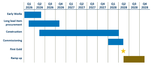
Figure 1: Doropo Project Timeline
During the Quarter capital expenditure on Doropo was $52.9 million with capital expenditure for the first nine months of 2026 totalling $93.1 million. Approximately $315 million (61%) of total capex has been committed.
Quarterly Activities
During Q3, procurement and construction activities advanced to plan. The Project achieved over 500,000 work hours without a lost time injury or medical treatment injury, with the site workforce increasing to more than 600 people. Post-quarter-end, the number of personnel on site increased to over 860, of whom approximately 80% are nationals with 25% from the local region.
Several key construction, engineering and procurement activities advanced during Q3. These included completion of earthworks design, mobilisation of additional contractors, commencement of concrete works and the continued awarding of major equipment and infrastructure packages.
Procurement
Key contracts awarded during the Quarter included:
• structural and platework fabrication,
• supply and installation of the High-Voltage ("HV") powerline, switchyard and HV transformer
• transport and logistics
• concrete works
Process equipment awards included the CIL gantry crane, wet vibrating screens, centrifugal gravity concentrators, intense cyanide leach reactor and mill reline equipment.
Tendering progressed for the CIL tank installation, steel-framed buildings and plant buildings, while procurement commenced for piping and electrical bulk materials.
Earthworks design for the TSF, water storage dam, water harvesting dam, airstrip, main access road and sediment control structures was completed during the Quarter.
Site Preparation and Construction
Earthworks for the construction camp and mine village were completed, while plant-site earthworks continued. Earthworks commenced at the mine services area, electrical switchyard, TSF and water storage dam. The exploration camp expansion was completed and handed over to Resolute.
Water supply development also advanced, with 26 exploration bore targets drilled and 11 additional pads identified and permitted. Installation activities commenced on the approximately 5.4km raw-water pipeline to the process plant raw-water pond.
The construction camp and village contractor completed mobilisation, with concrete and services installation commencing. The first construction camp buildings arrived on site and assembly began. Communications infrastructure also advanced with the erection of a 5G tower.
Concrete works progressed too with the mobilisation of the concrete contractor, excavation of the CIL ring beams and for the SAG and ball mill foundations. To date. approximately 210 tonnes of reinforcement steel had been delivered, the first concrete batch plant was commissioned, and formwork and reinforcement installation progressed on the CIL ring beams and grinding area foundations.
Grid power workstreams progressed with contracts awarded for the substations, 90/11 kV transformers and 90kV HV Transmission Line.
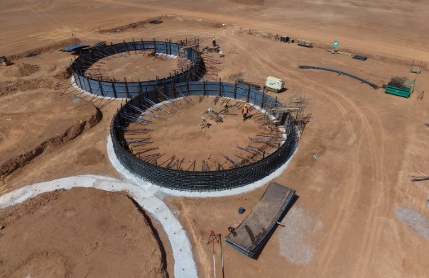
Figure 2: Ring Beam foundations
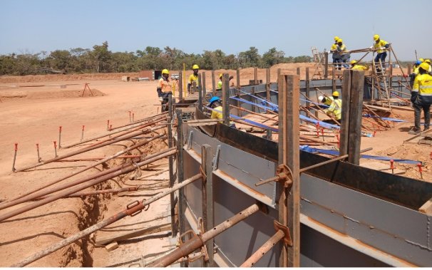
Figure 3: CIL Tank No. 8 Ring Beam
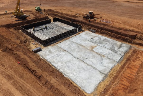
Figure 4: Mill area raft foundation
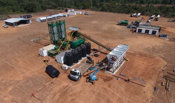
Figure 5: Concrete Batch Plant Commissioned
Land Access and Community Engagement
Land compensation and acquisition for project infrastructure areas was completed during the period, with access granted for early works areas.
Mining, Power and Owner’s Team
Tender evaluations progressed for the mining contractor, dewatering, grade control, explosives infrastructure and fuel and lubricant supply packages. The mine services area layout was also agreed.
The HV installation contractors mobilised during the Quarter. The solar power plant tender was issued and bids were received, with tender adjudication underway.
The owner’s team continued to expand through the addition of roles across ESG, accounting, construction and security.
Land Access and Compensation
The land survey for the mining area was concluded during the Quarter. Compensation was agreed for the starter pit, magazine and emulsion plant areas.
Planned Activities
During Q4, activities are planned to focus on progressing the Project into broader construction execution, including:
• Progressing the construction camp towards completion, with the progressive handover of accommodation rooms, and commencing mine village installation
• Completing plant-site and mine services area bulk earthworks and continuing works on the TSF, water storage dam and water harvesting dam
• Progressing concrete works across the CIL, milling, thickener, reclaim and crushing areas
• Mobilising the CIL tank installation contractor
• Completing water bore drilling, equipping the borefield and installing associated piping
• Commencing work on the HV power supply installation, including substation foundations and clearance of the overhead powerline corridor
• Awarding major mechanical, electrical, mining and solar power packages
• Progressing structural, mechanical, piping, electrical and instrumentation installation contracts
• Continuing detailed engineering, procurement and owner’s team mobilisation
The ABC Project is a greenfield exploration project located in northwestern Côte d'Ivoire. ABC is a priority growth project, and the Company continues to believe it has the potential to become its fourth mine furthering Resolute’s strategy of diversification in West Africa.
The current Mineral Resource Estimate at ABC is 133 Mt grading 0.71 g/t Au for 3.0 Moz (at 0.3 g/t cut off, $3,250/oz Au pit shell). The MRE is over the Kona South and Kona Central deposits which are located 3km apart. The third prospect, Moya, is located 8km north of Kona Central and represents a new growth target within the Kona permit.
|
|
Constrained ABC Inferred MRE | ||
Prospect |
|
Mt |
Grade (g/t Au) |
Moz (Au) |
Kona Central |
|
64.6 |
0.62 |
1.29 |
Kona South |
|
68.1 |
0.79 |
1.72 |
Total |
|
132.7 |
0.71 |
3.02 |
Table 2: ABC Mineral Resource Estimate (at 0.3 g/t cut-off, July 2026)
Since the MRE update, drilling activities at ABC have primarily focused on converting Inferred Mineral Resources to the Indicated category and expanding the overall Mineral Resource footprint.
During Q3, 23,900 m of infill drilling was completed. A remaining 33,000 m is planned over Q4 2026 with 11 rigs in operation currently and an updated MRE is targeted for Q1 2027. Drilling to date by Resolute has confirmed both Kona South and Kona Central remain open along strike and depth.
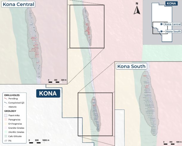
Figure 6: Plan of ABC Project Drill Programme
In addition to upgrading the MRE the work programme over the next twelve months will involve technical studies, environmental and social baseline work, metallurgical testwork and site infrastructure upgrades.
These initial stages of the ESIA study commenced in Q3 2026. Along with updating the MRE after completion of the current infill drilling programme, technical workstreams are commencing to support the Company’s objective of advancing ABC through feasibility studies by the end of 2027.
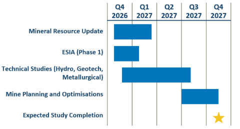
Figure 7: Approximate Study Schedule
The La Debo project is in the south of Côte d’Ivoire, approximately 280 km west of Abidjan.
In October 2025 Resolute was granted two additional exploration permits, Gagnoa and Soubre, situated to the south of the La Debo Project. In November 2025 Resolute announced an Inferred Mineral Resource Estimate for La Debo (G3N and G3S prospects) of 17.6Mt grading 1.14 g/t Au for 643 koz of contained gold at 0.5g/t cut-off.
A diamond drilling program to expand the Mineral Resources at G3 South commenced in March 2026. Drilling last year identified a coherent linear zone of very high-grade mineralisation at the deepest levels of G3 South which has excellent potential for an underground operation.
This drilling program aimed to drill out a panel of gold mineralisation over a strike length of 600m which may have the potential to form the basis of an underground operation. The drilling program was completed in July 2026 with a total of 52 diamond holes completed for 15,867m of drilling.
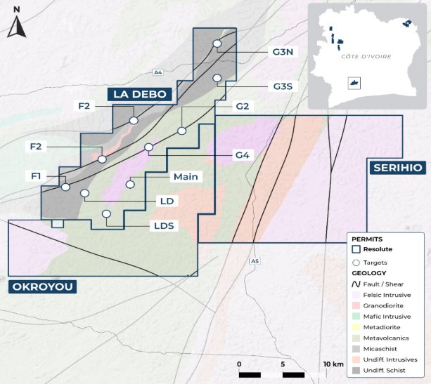
Figure 8: La Debo Project Permits and Prospect
The drilling in 2026 successfully extended the higher-grade mineralisation down dip at G3 South with mineralisation intersected in the majority of holes. A list of the significant drill intersections is attached as Appendix 2.
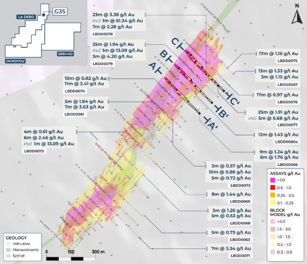
Figure 9: La Debo G3S Plan
Key intersections from the drilling program in 2026 are as follows.
LBDD0024 - 14m @ 8.70g/t Au from 154m
LBDD0026 - 9m @ 13.40g/t Au from 155m
LBDD0028 - 16m @ 4.57g/t Au from 141m
LBDD0053 - 15m @ 6.40g/t Au from 282m
LBDD0078 - 23m @ 3.38g/t Au from 176m
LBRC0034 - 23m @ 5.76g/t Au from 22m
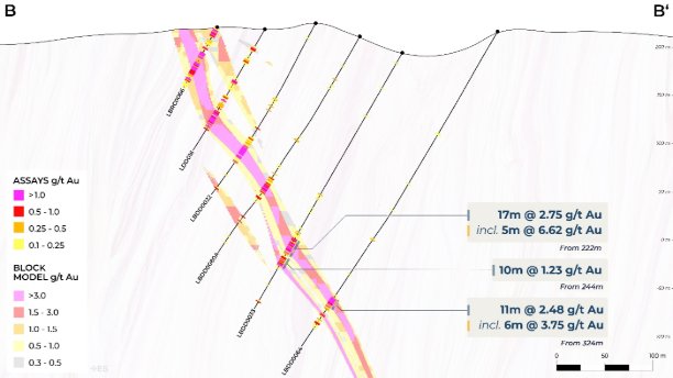
Figure 10: La Debo G3S Cross Section
An updated global Mineral Resource Estimate was undertaken in September with a 75% increase in the G3S resource to 14.9Mt grading 1.39g/t Au for 668,000oz at a cut off of 0.5g/t Au.
The total global Mineral Resource for the La Debo project is now 23.5Mt grading 1.23g/t Au for 927,000 ounces.
The drilling confirmed the higher grade core within G3S with a Mineral Resource of 4.2Mt grading 2.9g/t Au for 397,000 ounces.
|
|
2025 |
2026 | ||||
Prospect |
Cut-Off |
Tonnes |
Au Grade (g/t) |
Oz |
Tonnes |
Au Grade (g/t) |
Oz |
G3 North |
0.5 |
8,580,362 |
0.9 |
259,075 |
8,580,362 |
0.9 |
259,075 |
G3 South |
0.5 |
8,978,329 |
1.3 |
383,937 |
14,899,629 |
1.4 |
668,148 |
Total |
0.5 |
17,558,691 |
1.1 |
643,013 |
23,479,991 |
1.2 |
927,223 |
Table 3: La Debo Global Mineral Resources at 0.5g/t Au cut off
Weathering |
Tonnes |
Au Grade (g/t) |
Ounces |
Oxide |
570,098 |
2.9 |
52,870 |
Transitional |
81,091 |
2.8 |
7,313 |
Fresh |
3,545,807 |
3.0 |
336,506 |
Total |
4,196,996 |
2.9 |
396,689 |
Table 4: G3 South Prospect Mineral Resource at 1.5g/t Au cut off
La Debo Mineral Resource Estimation Summary
A summary of JORC Table 1 is provided below for compliance regarding the Mineral Resources reported within and in-line with requirements of ASX Listing Rule 5.8.1. More details are contained in the JORC Table 1.
The MRE for the G3 North prospect remains unchanged from July 2025. An updated MRE has been calculated for the G3 South prospect following additional drilling activity.
Geology and Geological interpretation
Mineralisation is currently interpreted to have a relatively simple geometry, comprising mineralised shears dipping at approximately 60 degrees to the east-south-east. G3S shows a mineralised zone of approximately 1.5km striking at approximately 040°.
Drilling techniques
Drill types used include reverse circulation with face sampling bit and core drilling using HQ and NQ sized bits. A total of 109 RC holes (10,422m) and 76 DD holes (20,618m) formed the input data to the updated MRE, which represents all RC and DD holes available for the prospect to date.
Sampling and sub-sampling techniques
Reverse circulation samples were collected on 1m intervals by riffle split (dry) or by scoop (wet) to obtain a 1-3kg sample.
Diamond drill core has been systematically cut lengthwise into half core with a diamond saw. Half core samples were selected for analysis.
Sample preparation includes oven drying, crushing to 10mm, splitting and pulverising to 85% passing - 75μm. These preparation techniques are deemed to be appropriate to the material being sampled.
Reverse circulation and core field duplicates were inserted by the company at a rate of 1:20 samples.
Sampling, sample preparation and quality control protocols are of industry standard, with the intention of ensuring an unbiased representative sample was collected.
Sample analysis method
All samples were dispatched to MSA Yamoussoukro for sample preparation and gold analysis by Chrysos Photon Assay. The analytical method is considered appropriate for the style of mineralisation.
No geophysical tools were used to determine elemental concentrations.
Quality control (QC) procedures included the use of certified standards (1:40), non-certified sand blanks
(1:40) and reverse circulation/core field duplicates (1:20).
Laboratory quality control data, including laboratory standards, blanks, duplicates, repeats, grind size results and sample weights were also captured into the digital database.
Analysis of the QC sample assay results indicates that an acceptable level of accuracy and precision has been achieved
Estimation Methodology
Volumes representing the mineralisation and weathering zones were built using the gold assay data and geological information logged by the geologists at the project site. Mineralised domains were built using a lower cut off grade of 0.2g/t Au to represent the mineralised envelope. Internal to some of the domains, higher grade sub-domains were built based on a nominal cut off grade of 1.5g/t.
Drill holes were flagged with the domain codes and composited to a standard 1m length within the domains, which represents the majority sample length. Small residual composites were spread equally across the composited interval.
Geostatistical analysis including continuity analysis (variography), and assessment of top-cut requirements was made for each domain and sub domain. Since the 1.5g/t Au sub domains are not yet confidently linked to an identifiable geological change, variograms were calculated and modelled using the entire domain datasets, combining the 1.5g/t and 0.2g/t composites where applicable. Top cuts were applied to most domains to manage the influence of outlier grades on the estimate.
A single block model was built to cover the entire prospect area, using a parent block size of 20m x 20m x 5m. The model is rotated 40° around the Z axis to align with the strike of the mineralisation. The estimates were made using a three-pass Ordinary Kriging workflow, resulting in >90% of blocks being estimated. Each pass used a broader search and fewer minimum required samples than the previous pass. Spatial constraining of the influence of the highest grades was applied in addition to top-cuts for one of the 0.2g/t Au domains and two of the 1.5g/t Au sub-domains. This technique honours the (top cut if applicable) composite grade locally, but beyond an applied distance resets the grade to a supplied threshold grade, further constraining the influence of high grades away from the drillholes, if required.
Unestimated blocks were applied the default value of the cut off grade used during domain construction; 0.2g/t Au for the broader zones and 1.5g/t Au for the internal sub-domains. The background waste zone was given the default value of 0.005g/t Au.
Classification criteria
Mineral Resources were classified in accordance with the Australasian Code for the Reporting of Exploration Results, Mineral Resources and Ore Reserves (JORC, 2012).
The deposit has been classified as Inferred Mineral Resource based on a combination of quantitative and qualitative criteria which include geologic continuity, confidence in volume models, data quality, sample spacing, lode continuity, and estimation parameters (number of informing composites, estimation pass number, kriging quality parameters, and minimum and average distance composites). Even where the geological and statistical factors may support a higher classification, the Inferred status recognises the requirement for more comprehensive metallurgical understanding.
The input data is consistent in its coverage of the modelled zones and does not favour or misrepresent the in-situ mineralisation. The definition of the mineralised zones is based on a moderate level of geologic understanding from good quality sample data. Validation of the block model shows good correlation of the input data to the block estimated grades.
Basis for selected cut-off grade
The cut-off grade of 0.5g/t Au is selected based on this being historically used to define the Mineral Resources at similar deposits in terms of grade, scale and proximity to surface in the Resolute portfolio. Further economic analysis will determine if a different cut-off grade is more appropriate for future La Debo Mineral Resource calculations.
Mining and metallurgical methods and other material modifying factors
Basic metallurgical testwork has been performed with more extensive investigations planned for future sampling campaigns. No mining modifying factors are yet applied to the MRE.
Planned Next Steps at La Debo
The high grade core at G3S remains open along strike and down dip and further resource increases are expected with additional drilling.
Previous encouraging drilling results at the La Debo Main prospect will be tested with upcoming exploration programs.
The Joint Venture has a newly granted permit named Soubre to the south-west of the main La Debo permit. Soubre has previously untested widespread gold in soil anomalies which will be drilled in 2027.
In Q3 2026, exploration drilling commenced at the Kilosegui prospect, which is located within the Doropo Exploitation Permit. Of the eight pits that make up the mine plan in the DFS Kilosegui has the largest Ore Reserve (21.8 Mt grading 1.22 g/t for 856 koz of contained gold at a reserve gold price assumption of $1,950/oz).
The current Mineral Resource at Kilosegui is 40Mt grading 1.1g/t for 1.4Moz with excellent potential for resource expansion. Kilosegui has a 6km strike length and is open at depth along the entire strike length of the deposit. The initial strategy is to expand the Kilosegui Mineral Resources at depth but within the top 200m.
An initial 20,000m combined RC and step out diamond drilling program is planned to test the down dip extensions of a 1.8km section of Kilosegui West and a 1.5km section of the Kilosegui Central zone.
The drilling program at Kilosegui will continue into 2027 and will expand to include major drilling programs at the Main Cluster Zone.
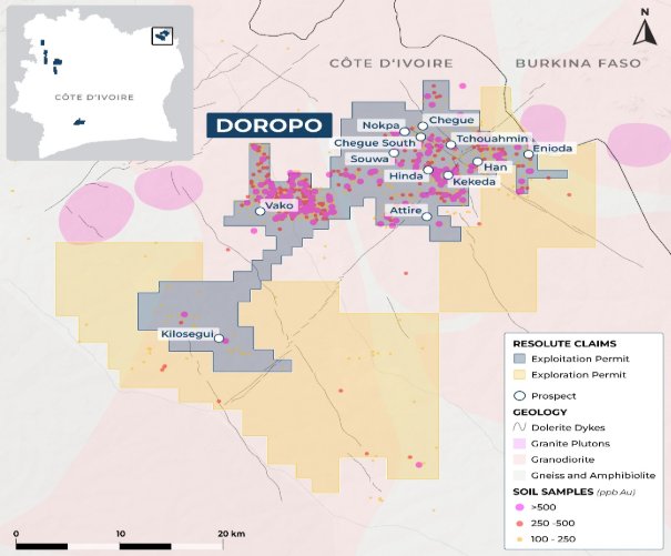
Figure 11: Map of deposits and prospects at Doropo
Mali
Syama gold production for the Quarter was 31,777oz at an AISC of $2,596/oz. The operational performance is set out in the table below.
Summary |
Units |
September 2026 Quarter |
June 2026 Quarter |
Nine Months 2026 YTD |
Nine Months 2025 YTD | |
Mining |
Underground |
|
|
|
|
|
Ore Mined |
t |
490,070 |
542,483 |
1,744,271 |
1,450,177 | |
Mined Grade |
g/t |
2.09 |
1.90 |
2.09 |
2.38 | |
Open Pit |
|
|
|
|
| |
Ore Mined |
t |
300,182 |
154,023 |
536,923 |
700,299 | |
Mined Grade |
g/t |
2.11 |
1.78 |
2.01 |
1.46 | |
Processing |
Sulphide |
|
|
|
|
|
Ore Processed |
t |
655,115 |
486,231 |
1,843,597 |
1,777,320 | |
Processed Grade |
g/t |
2.15 |
1.95 |
2.15 |
2.22 | |
Recovery |
% |
72 |
75 |
74 |
76 | |
Gold Poured |
oz |
30,439 |
23,460 |
93,298 |
99,438 | |
Gold Sold |
oz |
20,762 |
27,457 |
98,007 |
100,919 | |
Oxide |
|
|
|
|
| |
Ore Processed |
t |
53,741 |
272,632 |
683,596 |
1,174,109 | |
Processed Grade |
g/t |
0.61 |
0.82 |
0.69 |
0.97 | |
Recovery |
% |
76 |
73 |
74 |
82 | |
Gold Poured |
oz |
1,338 |
6,421 |
12,162 |
29,740 | |
Gold Sold |
oz |
1,338 |
6,421 |
12,162 |
29,740 | |
Cost |
Syama combined |
|
|
|
|
|
Capital Expenditure |
$m |
18.6 |
15.6 |
54.5 |
42.5 | |
AISC |
$/oz |
2,596 |
2,654 |
2,459 |
2,092 | |
Table 5: Syama Production and Cost Summary
Production during Q3 was 31.8 koz with performance weighted towards the back end of the quarter. Operational challenges including slower-than-planned open pit mining rates at A21, intermittent explosive supply constraints underground, periodic plant downtime and challenges with the Roaster upgrade were most pronounced in July and August. However, September saw a meaningful recovery, with monthly production of approximately 15.5 koz, reflecting the mobilisation of additional contractor fleet, the resumption of underground emulsion deliveries and improving access to ore. The Company expects this improving trajectory to continue for the remainder of the year.
Underground mining produced 0.49 Mt of ore at an average grade of 2.09 g/t. Ore tonnes were lower than Q2, while grade improved. Performance remained constrained by intermittent explosive availability and blasting limitations in wet production areas. During the quarter, underground emulsion deliveries resumed which helped to improve underground mining activities. The on-site emulsion plant is currently being commissioned with benefits expected to be seen in Q4.
Open pit mining produced 0.30 Mt of ore at an average grade of 2.11 g/t, with total material movement of 3.51 Mt. Mining rates at A21 remained below plan during the quarter, due to the transition to a new mining contractor. Mobilisation of the contractor fleet accelerated towards quarter end, with additional equipment arriving to support higher mining rates and improved access to ore.
During Q3, 0.71 Mt of ore was processed across the sulphide (0.66 Mt) and oxide (0.05 Mt) circuits. For the remainder of the year, a blended sulphide feed sourced from A21, underground ore and stockpiles is planned to support plant and circuit optimisation as the SSCP is commissioned.
Oxide processing totalled 0.05 Mt during the quarter. Open pit mining at A21 and Folona is expected to continue building oxide stockpiles for future processing, while the mobilisation of additional mining equipment is intended to support improved ore availability. In-pit tailings disposal continues in the beta pit with the Company liaising with the government on an extension beyond the end of 2026 as well as alternative options.
Regarding the SSCP, commissioning on the Roaster circuit upgrades was completed although behind schedule as visa restrictions in Mali allowed for only half of the contractor workforce to mobilise. During Q3 work continued on the secondary crusher and ball mill circuits which are due to be commissioned over the coming months. The project has no LTIs after approximately 1.4 million person-hours worked until the end of September 2026.
During Q3 capital expenditure was $18.6 million. Expenditure for the Quarter includes underground production mobile machinery, and TSF lift, with $6.3 million spent on the SSCP and Roaster upgrade as well as $11.3 million of sustaining waste capital. Full year capital expenditure is expected to be below original guidance ($70 - 85 million) due to reduced waste stripping.
In Q3 the AISC of $2,596/oz was lower than Q2, primarily due to lower royalties on lower average realised gold prices. As noted previously Syama full-year AISC is expected to be $2,300 - 2,400/oz on lower full-year production (150 - 160 koz).
Mako Operations
Mako gold production for the Quarter was 12,621oz at an AISC of $1,516/oz The operational performance for Mako is set out in the table below.
Summary |
Units |
September 2026 Quarter |
June 2026 Quarter |
Nine Months 2026 YTD |
Nine Months 2025 YTD |
Mining |
|
|
|
|
|
Ore Mined |
t |
- |
- |
- |
1,242,013 |
Mined Grade |
g/t |
- |
- |
- |
1.9 |
Processing |
|
|
|
|
|
Ore Processed |
t |
504,296 |
626,309 |
1,704,143 |
1,677,288 |
Processed Grade |
g/t |
0.85 |
0.83 |
0.87 |
1.66 |
Recovery |
% |
91 |
91 |
90 |
92 |
Gold Poured |
oz |
12,621 |
15,311 |
43,733 |
82,140 |
Gold Sold |
oz |
10,935 |
20,720 |
46,817 |
77,944 |
Financials |
|
|
|
|
|
Capital Expenditure |
$m |
3.3 |
1.9 |
9.6 |
2.6 |
AISC |
$/oz |
1,516 |
1,538 |
1,579 |
1,180 |
Table 6: Mako Production and Cost Summary
During the Quarter, the plant treated 504.3 kt of stockpiled ore at a head grade of 0.85 g/t Au and a recovery of 91%, producing 12,621oz of gold. Throughput was lower than in the June quarter due to a mill motor failure which resulted in ten days of downtime. Year-to-date gold production of 43.7 koz means Mako remains on track for full-year production guidance of 55 - 65 koz.
The Q3 AISC of $1,516/oz was below the lower end of Mako’s full-year guidance of $1,600 – 1,800/oz. The result reflects the cost optimisation programme, under which lower rehandle, processing and maintenance costs reduced site operating costs.
Capital expenditure at Mako for the Quarter was $3.3 million. This includes sustaining capital of $1.2 million and was associated with the planned plant maintenance and upgrades, along with $2.1 million expenditure on MLEP. Full-year capital expenditure remains within guidance of $5.0 million.
There were no material supply disruptions in Senegal during the Quarter.
Mako Life Extension Project (MLEP)
The MLEP is expected to extend the life of the Mako Gold Mine through the development of the Tomboronkoto and Bantaco satellite deposits, approximately 20 km from the Mako processing plant.
Work during Q3 focused on permitting, ESIA public hearings and the Relocation Action Plan (RAP).
MLEP expenditure for the Quarter was $2.1 million, mainly on permitting and the ESIA process, Bantaco infill drilling, RAP development and engineering studies. Full year MLEP expenditure remains within guidance of $10-15 million.
The integrated MLEP schedule (Figure 12) and the phasing of remaining capital have been updated. The exploration permit transfers remain on the critical path and are expected in Q4 2026, with the exploitation permits for both deposits expected in H1 2027. Bantaco mining is planned from July 2027 to the end of 2028, subject to the update of its mining schedule, and Tomboronkoto mining remains targeted to start in January 2029.
RAP work focused on agreeing the relocation package with the community. Preliminary agreement on compensation rates and entitlement principles was reached with the Tomboronkoto community consultation and resettlement committee. The village housing and public facility designs are in final review.
RAP Phase 1 (studies, designs and agreements) is scheduled for completion by the end of Q1 2027. RAP Phase 2 (construction of the new village and physical relocation) will start once the exploitation permit is granted and agreement has been reached with the community and is scheduled from Q2 2027 to the end of 2028. The mining and haulage and ore transport road construction tenders closed during the Quarter through the Local Content Platform and are being evaluated.
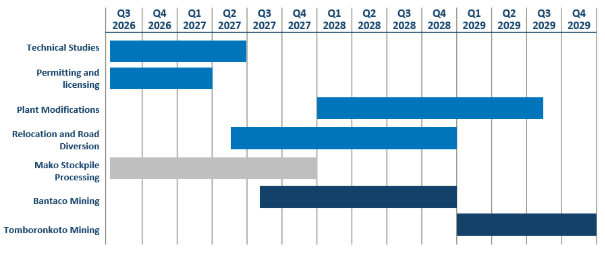
Figure 12: Approximate Timeline for the MLEP
Next Steps
Key next steps for the MLEP are:
• Receipt of the Tomboronkoto and Bantaco exploration permit transfer orders, expected in Q4 2026, followed by immediate lodgement of the Tomboronkoto exploitation permit application and lodgement of the Bantaco application once its ESIA attestation is received
• Receipt of the ESIA attestations and environmental compliance certificates for the three validated sectoral ESIAs
• Agreement on the Tomboronkoto relocation package and the Bantaco livelihood restoration approach, completing RAP Phase 1 by the end of Q1 2027
• Finalisation of the new village design and construction tender documents, ready for RAP Phase 2 to start once the exploitation permit is granted and agreement has been reached with the community
• Completion of the mining and haulage and ore transport road tender evaluations
During the quarter Resolute completed the incorporation of its joint venture company with its state-owned partner Nimba Mining Gold (NMG). The joint venture was officially named Landaya Gold. Each shareholder initially holds 50% in Landaya.
Subsequently the partners worked together to select areas of interest and to prepare licence applications which are being filed.
In addition to the Landaya joint venture, Resolute is reviewing additional partnership opportunities and is reinforcing its presence in the country.
Financial Highlights and Balance Sheet Activities
Quarterly Net Cash Movements ($ million)
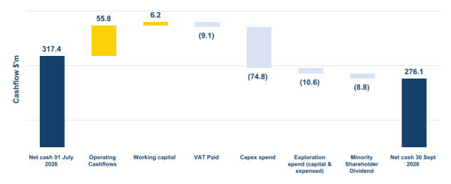
Figure 13: Q3 2026 Net Cash Movements
In Q3 gold sales of 33,035 oz (Q2 2026: 54,599 oz) were achieved at an average realised gold price of $4,325/oz (Q2: $4,526/oz), with all gold being sold at spot prices. The continued strong gold price environment helped the Company generate an operating cashflow of $55.8 million in Q3.
For Q3 there was a working capital inflow of $6.2 million (Q2 2026: $2.2 million outflow). The working capital inflow was principally attributable to a change in payables settled through the normal course of business.
EBITDA for Q3 was $64.0 million (Q2 2026: $128.5 million) reflecting $142.9 million of revenue (Q2 2026: $247.1 million). The decrease from the prior quarter is due to the decrease in gold sales due to timing of gold shipments.
Total Group exploration spend, including capital and operating expenditure, in Q3 was $10.6 million (Q2 2026: $10.1 million), with drilling programs continuing in Senegal ($0.9 million), Côte d’Ivoire ($9.0 million) and Mali ($0.7 million). The majority of exploration spend during the Quarter was at the ABC Project in Côte d’Ivoire with 23,900 m of infill drilling completed.
Year-to-date exploration expenditure is $25.2 million which is at the top end of initial guidance ($15 - 25 million). In Q4 2026 the Company expects to spend a further $10 million as a result of ongoing infill drilling at the ABC Project and extension drilling at the Kilosegui deposit at Doropo.
Net cash (including fixed term deposits and bullion, less drawn overdraft and borrowings) at 30 September 2026 was $276.1 million, increasing from $209.1 million at 31 December 2025. The Company has available liquidity of approximately $479.6 million (including $95.4 million bullion on hand) as at 30 September 2026.
Total borrowings at 30 September 2026 were $54.2 million (Q2 2026: $15.2 million) which includes in-country overdraft facilities in Senegal of $1.2 million, Mali of $15.6 million, as well as $8.1 million for in-country equipment financing in Mali. In Q3, Resolute secured local financing for the capital spend in Doropo, of which $29.4 million has been drawn and included in total borrowings. Cash, cash equivalents and bullion reduced by $2.4 million in the Quarter to $330.3 million (Q2 2026: $332.7 million).
Financing Update
Post Quarter-End, Resolute secured the full local financing arrangements for Doropo, with $260.0 million of credit facilities implemented. All facilities have attractive terms including minimal security commitments and no financial covenants.
As of 30 September, FCFA 17 billion were drawn (c. $29.4 million) under the facilities, with remaining funds expected to be gradually drawn over 2026 and 2027, in line with increased capital spend at Doropo.
Local bank facilities along with Resolute's existing balance sheet and operating cash flow provides sufficient liquidity to finance the development of the Doropo Project under current market and regulatory conditions.
Resolute Matthias O’Toole Howes, Corporate Development and Investor Relations Manager Matthias.otoolehowes@resolutemining.com +44 203 3017 620 |
Public Relations Jos Simson, Tavistock +44 207 920 3150
Corporate Brokers Jennifer Lee, Berenberg +44 20 3753 3040
Tom Rider, BMO Capital Markets +44 20 7236 1010 |
|
About Resolute
Resolute is an African-focused gold miner with more than 30 years of experience as an explorer, developer and operator. Throughout its history the Company has produced more than 9 million ounces of gold from ten gold mines. The Company is now entering a growth phase through the development of the Doropo project in Côte d’Ivoire which will supplement the existing production from the Syama mine in Mali and Mako mine in Senegal.
Through all its activities, sustainability is the core value at Resolute. This means that protecting the environment, providing a safe and productive working environment for employees, uplifting host communities, and practicing good corporate governance are non-negotiable priorities. Resolute’s commitment to sustainability and good corporate citizenship has been cemented through its adoption of and adherence to the Responsible Gold Mining Principles (RGMPs). This framework, which sets out clear expectations for consumers, investors, and the gold supply chain as to what constitutes responsible gold mining, is an initiative of the World Gold Council of which Resolute has been a full member since 2017.
Q3 Production and Costs (unaudited)
September 2026 - Quarter to date |
Units |
Syama |
Mako |
Group Total |
UG Lateral Development |
m |
891 |
- |
891 |
UG Vertical Development |
m |
- |
- |
- |
Total UG Development |
m |
891 |
- |
891 |
UG Ore Mined |
t |
490,070 |
- |
490,070 |
UG Grade Mined |
g/t |
2.09 |
- |
2.09 |
OP Operating Waste |
BCM |
1,262,835 |
- |
1,262,835 |
OP Ore Mined |
BCM |
119,714 |
- |
119,714 |
OP Grade Mined |
g/t |
2.11 |
- |
2.11 |
Total Ore Mined |
t |
790,252 |
- |
790,252 |
Total Tonnes Processed |
t |
708,856 |
504,296 |
1,213,152 |
Grade Processed |
g/t |
2.04 |
0.85 |
1.54 |
Recovery |
% |
73 |
91 |
80 |
Gold Recovered |
oz |
33,612 |
12,645 |
46,257 |
Gold in Circuit Drawdown/(Addition) |
oz |
(1,835) |
(24) |
(1,859) |
Gold Produced (Poured) |
oz |
31,777 |
12,621 |
44,398 |
Gold Bullion in Metal Account Movement (Increase)/Decrease |
oz |
(9,677) |
(1,686) |
(11,363) |
Gold Sold |
oz |
22,100 |
10,935 |
33,035 |
Achieved Gold Price |
$/oz |
- |
- |
4,325 |
Cost Summary |
|
|
|
|
Mining |
$/oz |
1,032 |
137 |
777 |
Processing |
$/oz |
1,175 |
831 |
1,077 |
Site Administration |
$/oz |
287 |
347 |
304 |
Site Operating Costs |
$/oz |
2,494 |
1,314 |
2,159 |
Royalties |
$/oz |
351 |
217 |
313 |
By-Product Credits |
$/oz |
(6) |
- |
(4) |
Total Cash Operating Costs |
$/oz |
2,840 |
1,531 |
2,468 |
Sustaining Capital & Others |
$/oz |
231 |
42 |
394 |
Inventory Adjustments |
$/oz |
(474) |
(58) |
(356) |
All-In Sustaining Cost (AISC) AISC is calculated on gold produced (poured) |
$/oz |
2,596 |
1,516 |
2,506 |
Year-to-date 2026 Production and Costs (unaudited)
September 2026 - Year to date |
Units |
Syama |
Mako |
Group Total |
UG Lateral Development |
m |
2,471 |
- |
2,471 |
UG Vertical Development |
m |
- |
- |
- |
Total UG Development |
m |
2,471 |
- |
2,471 |
UG Ore Mined |
t |
1,744,271 |
- |
1,744,271 |
UG Grade Mined |
g/t |
2.09 |
- |
2.09 |
OP Operating Waste |
BCM |
2,082,994 |
- |
2,082,994 |
OP Ore Mined |
BCM |
207,981 |
- |
207,981 |
OP Grade Mined |
g/t |
2.01 |
- |
2.01 |
Total Ore Mined |
t |
2,281,194 |
- |
2,281,194 |
Total Tonnes Processed |
t |
2,527,193 |
1,704,143 |
4,231,336 |
Grade Processed |
g/t |
1.75 |
0.87 |
1.40 |
Recovery |
% |
74 |
90 |
80 |
Gold Recovered |
oz |
106,111 |
43,532 |
149,643 |
Gold in Circuit Drawdown/(Addition) |
oz |
-651 |
201 |
-450 |
Gold Produced (Poured) |
oz |
105,460 |
43,733 |
149,193 |
Gold Bullion in Metal Account Movement (Increase)/Decrease |
oz |
4,708 |
3,085 |
7,793 |
Gold Sold |
oz |
110,169 |
46,817 |
156,986 |
Achieved Gold Price |
$/oz |
- |
- |
4,631 |
Cost Summary |
|
|
|
|
Mining |
$/oz |
769 |
173 |
594 |
Processing |
$/oz |
995 |
794 |
936 |
Site Administration |
$/oz |
269 |
306 |
280 |
Site Operating Costs |
$/oz |
2,033 |
1,273 |
1,810 |
Royalties |
$/oz |
522 |
278 |
450 |
By-Product Credits |
$/oz |
(8) |
- |
(6) |
Total Cash Operating Costs |
$/oz |
2,547 |
1,551 |
2,254 |
Sustaining Capital & Others |
$/oz |
152 |
26 |
294 |
Inventory Adjustments |
$/oz |
(239) |
3 |
(169) |
All-In Sustaining Cost (AISC) per ounce poured |
$/oz |
2,459 |
1,579 |
2,379 |
ASX Listing Rule 5.23 Mineral Resources
This announcement contains estimates of Resolute’s mineral resources. The information in this Quarterly report that relates to the mineral resources of Resolute has been extracted from reports entitled ‘Ore Reserves and Mineral Resource Statement’ announced on 5 March 2026, 'Updated Mineral Resource Estimate at the ABC Project' announced on 22 July 2026. These are available to view on Resolute’s website (www.rml.com.au) and www.asx.com (Resolute Announcement).
For the purposes of ASX Listing Rule 5.23, Resolute confirms that it is not aware of any new information or data that materially affects the information included in the Resolute Announcement and, in relation to the estimates of Resolute's ore reserves and mineral resources, that all material assumptions and technical parameters underpinning the estimates in the Resolute Announcement continue to apply and have not materially changed. Resolute confirms that the form and context in which the Competent Person's findings are presented have not been materially modified from that announcement.
Cautionary Statement about Forward-Looking Statements
This announcement contains certain “forward-looking statements” including statements regarding our intent, belief, or current expectations with respect to Resolute’s business and operations, market conditions, results of operations and financial condition, and risk management practices. The words "likely", "expect", "aim", "should", "could", "may", "anticipate", "predict", "believe", "plan", "forecast" and other similar expressions are intended to identify forward-looking statements. Indications of, and guidance on, future earnings, anticipated production, life of mine and financial position and performance are also forward-looking statements. These forward-looking statements involve known and unknown risks, uncertainties and other factors that may cause Resolute’s actual results, performance and achievements or industry results to differ materially from any future results, performance or achievements, or industry results, expressed or implied by these forward-looking statements. Relevant factors may include (but are not limited to) changes in commodity prices, foreign exchange fluctuations and general economic conditions, increased costs and demand for production inputs, the speculative nature of exploration and project development, including the risks of obtaining necessary licences and permits and diminishing quantities or grades of reserves, political and social risks, changes to the regulatory framework within which Resolute operates or may in the future operate, environmental conditions including extreme weather conditions, recruitment and retention of personnel, industrial relations issues and litigation.
Forward-looking statements are based on Resolute’s good faith assumptions as to the financial, market, regulatory and other relevant environments that will exist and affect Resolute’s business and operations in the future. Resolute does not give any assurance that the assumptions will prove to be correct. There may be other factors that could cause actual results or events not to be as anticipated, and many events are beyond the reasonable control of Resolute. Readers are cautioned not to place undue reliance on forward-looking statements, particularly in the significantly volatile and uncertain current economic climate. Forward-looking statements in this document speak only at the date of issue. Except as required by applicable laws or regulations, Resolute does not undertake any obligation to publicly update or revise any of the forward-looking statements or to advise of any change in assumptions on which any such statement is based. Except for statutory liability which cannot be excluded, each of Resolute, its officers, employees and advisors expressly disclaim any responsibility for the accuracy or completeness of the material contained in these forward-looking statements and excludes all liability whatsoever (including in negligence) for any loss or damage which may be suffered by any person as a consequence of any information in forward-looking statements or any error or omission.
The information in this report that relates to the Exploration Results is based on information compiled by Mr Bruce Mowat, a member of The Australian Institute of Geoscientists. Mr Bruce Mowat has more than 15 years’ experience relevant to the styles of mineralisation and type of deposit under consideration and to the activity which he is undertaking to qualify as a Competent Person, as defined in the 2012 Edition of the “Australasian Code for Reporting of Exploration Results, Mineral Resources and Ore Reserves” (the JORC Code). Mr Bruce Mowat is a full-time employee of the Resolute Mining Limited Group and holds equity securities in the Company. He has consented to the inclusion of the matters in this report based on his information in the form and context in which it appears. This information was prepared and disclosed under the JORC Code 2012 except where otherwise noted.
The information in this announcement that relates to the Mineral Resource estimate has been based on information and supporting documents prepared by Mr James Woodward, a Competent Person who is a member of The Australasian Institute of Mining and Metallurgy. Mr Woodward is a full-time employee Resolute Mining Limited Group and has sufficient experience relevant to the style of mineralisation and type of deposit under consideration and to the activity which has been undertaken to qualify as a Competent Person. Mr Woodward confirms that the Mineral Resource estimate is based on information in the supporting documents and consents to the inclusion in the report of the Mineral Resource estimate and related content based on the information in the form and context in which it appears.
Appendix 2. Recent drilling results at La Debo
Prospect |
Hole_ID |
Nat_Grid |
NAT_North |
NAT_East |
NAT_RL |
Dip |
Azimuth |
From |
To |
Width |
Au g/t |
G3S |
LBDD0033 |
WGS84_29N |
665684 |
815933 |
194 |
-60 |
315 |
222 |
239 |
17 |
3 |
G3S |
LBDD0033 |
WGS84_29N |
665684 |
815933 |
194 |
-60 |
315 |
244 |
254 |
10 |
1 |
G1 |
LBDD0035 |
WGS84_29N |
660054 |
806251 |
215 |
-60 |
315 |
22 |
31 |
9 |
1 |
G3S |
LBDD0036 |
WGS84_29N |
665719 |
815968 |
216 |
-60 |
315 |
225 |
238 |
13 |
2 |
G3S |
LBDD0038 |
WGS84_29N |
665755 |
816002 |
196 |
-60 |
315 |
222 |
238 |
16 |
1 |
G3S |
LBDD0039 |
WGS84_29N |
664938 |
815479 |
211 |
-60 |
315 |
260 |
265 |
5 |
2 |
G3S |
LBDD0040 |
WGS84_29N |
665791 |
816039 |
212 |
-60 |
315 |
225 |
246 |
21 |
3 |
G3S |
LBDD0041 |
WGS84_29N |
664872 |
815481 |
231 |
-60 |
315 |
307 |
324 |
17 |
1 |
G3S |
LBDD0043 |
WGS84_29N |
665824 |
816004 |
213 |
-60 |
315 |
174 |
195 |
21 |
3 |
G3S |
LBDD0046 |
WGS84_29N |
665864 |
816066 |
210 |
-60 |
315 |
192 |
201 |
9 |
1 |
G3S |
LBDD0048 |
WGS84_29N |
665467 |
815808 |
202 |
-60 |
315 |
288 |
306 |
18 |
1 |
G3S |
LBDD0049 |
WGS84_29N |
665649 |
815897 |
195 |
-60 |
315 |
238 |
243 |
5 |
6 |
G3S |
LBDD0049 |
WGS84_29N |
665649 |
815897 |
195 |
-60 |
315 |
219 |
229 |
10 |
2 |
G3S |
LBDD0051 |
WGS84_29N |
665621 |
815857 |
204 |
-60 |
315 |
208 |
220 |
12 |
4 |
G3S |
LBDD0051 |
WGS84_29N |
665621 |
815857 |
204 |
-60 |
315 |
229 |
238 |
9 |
1 |
G3S |
LBDD0053 |
WGS84_29N |
665501 |
815841 |
213 |
-60 |
315 |
282 |
297 |
15 |
6 |
G3S |
LBDD0055 |
WGS84_29N |
665590 |
815816 |
217 |
-50 |
315 |
200 |
209 |
9 |
1 |
G3S |
LBDD0057A |
WGS84_29N |
665685 |
816075 |
185 |
-60 |
315 |
317 |
330 |
13 |
1 |
G3S |
LBDD0060 |
WGS84_29N |
665038 |
815614 |
221 |
-60 |
315 |
370 |
373 |
3 |
4 |
G3S |
LBDD0061 |
WGS84_29N |
665648 |
816039 |
215 |
-60 |
315 |
324 |
341 |
17 |
2 |
G3S |
LBDD0061 |
WGS84_29N |
665648 |
816039 |
215 |
-60 |
315 |
349 |
355 |
6 |
3 |
G3S |
LBDD0062 |
WGS84_29N |
665578 |
815970 |
216 |
-60 |
315 |
322 |
335 |
13 |
1 |
G3S |
LBDD0064 |
WGS84_29N |
665614 |
816002 |
216 |
-60 |
315 |
324 |
335 |
11 |
2 |
G3S |
LBDD0065 |
WGS84_29N |
665719 |
816110 |
212 |
-60 |
315 |
328 |
335 |
7 |
2 |
G3S |
LBDD0066 |
WGS84_29N |
665549 |
815927 |
194 |
-60 |
315 |
316 |
325 |
9 |
1 |
G3S |
LBDD0066 |
WGS84_29N |
665549 |
815927 |
194 |
-60 |
315 |
331 |
337 |
6 |
2 |
G3S |
LBDD0067 |
WGS84_29N |
665790 |
816136 |
183 |
-60 |
315 |
281 |
294 |
13 |
1 |
G3N |
LBDD0069 |
WGS84_29N |
665243 |
815659 |
211 |
-60 |
315 |
295 |
303 |
8 |
1 |
G3S |
LBDD0071 |
WGS84_29N |
664795 |
815557 |
207 |
-60 |
315 |
401 |
408 |
7 |
3 |
G3N |
LBDD0073 |
WGS84_29N |
665344 |
815576 |
187 |
-60 |
315 |
167 |
173 |
6 |
2 |
G3S |
LBDD0074 |
WGS84_29N |
665629 |
815781 |
220 |
-60 |
315 |
168 |
179 |
11 |
2 |
G3S |
LBDD0075 |
WGS84_29N |
665826 |
816100 |
210 |
-60 |
315 |
237 |
254 |
17 |
1 |
G3S |
LBDD0076 |
WGS84_29N |
665752 |
816074 |
212 |
-60 |
315 |
262 |
279 |
17 |
1 |
G3S |
LBDD0077 |
WGS84_29N |
665718 |
816040 |
214 |
-60 |
315 |
258 |
283 |
25 |
2 |
G3S |
LBDD0078 |
WGS84_29N |
665788 |
815969 |
215 |
-60 |
315 |
176 |
199 |
23 |
3 |
G3S |
LBDD0078 |
WGS84_29N |
665788 |
815969 |
215 |
-60 |
315 |
236 |
243 |
7 |
2 |
G3S |
LBDD0079 |
WGS84_29N |
665748 |
815938 |
217 |
-60 |
315 |
185 |
210 |
25 |
2 |
G3S |
LBDD0079 |
WGS84_29N |
665748 |
815938 |
217 |
-60 |
315 |
242 |
245 |
3 |
4 |
G3S |
LBDD0080A |
WGS84_29N |
665715 |
815902 |
211 |
-60 |
315 |
179 |
191 |
12 |
1 |
G3S |
LBDD0081 |
WGS84_29N |
665510 |
815758 |
206 |
-60 |
315 |
199 |
206 |
7 |
4 |
Notes to Accompany Table: |
• Grid coordinates are WGS84 Zone 29 North |
• RC intervals are sampled every 1m by dry riffle splitting or scoop to provide a 2-3kg sample |
• Diamond core are sampled every 1m by cutting the core in half to provide a 2-4kg sample |
• Cut-off grade for reporting of intercepts is >0.5g/t Au with a maximum of 3m consecutive internal dilution included within the intercept; only intercepts =>3m and >10 gram x metres are reported |
• Drill samples are analysed for gold by MSA Labs CPA-Au1 500g sample gamma ray analysis by photon assay instrument |
JORC Code, 2012 Edition – Table 1 report
Section 1 Sampling Techniques and Data
La Debo Project
CRITERIA |
JORC CODE EXPLANATION |
COMMENTARY |
Sampling techniques |
• Nature and quality of sampling (e.g. cut channels, random chips, or specific specialised industry standard measure-ment tools appropriate to the minerals under investigation, such as down hole gamma sondes, or handheld XRF instruments, etc.). These examples should not be taken as limiting the broad meaning of sampling. • Include reference to measures taken to ensure sample representivity and the appropriate calibration of any measurement tools or systems used. • Aspects of the determination of mineralisation that are Mate-rial to the Public Report. • In cases where ‘industry standard’ work has been done this would be relatively simple (e.g. ‘reverse circulation drilling was used to obtain 1 m samples from which 3 kg was pulverised to produce a 30 g charge for fire assay’). In other cases more explanation may be required, such as where there is coarse gold that has inherent sampling problems. Unusual commodities or mineralisation types (e.g. submarine nodules) may warrant disclosure of detailed information. |
Diamond core has been geologically logged and sampled to geo-logical contacts with nominal sample lengths between 0.3m and 4.5m (most commonly 1m). Core selected for assay is systemati-cally cut lengthwise into half core by diamond blade rock saw, numbered and bagged before dispatch to the laboratory for anal-ysis.
All core is photographed, wet and dry. Reverse circulation chips are geologically logged and sampled on regular lengths of 1m. Chip material selected for assay is sys-tematically divided to a 1/8 proportion using a rotary splitter at-tached to the cyclone sample recovery system, numbered and bagged before dispatch to the laboratory for analysis. |
Drilling techniques |
• Drill type (e.g. core, reverse circulation, open-hole hammer, rotary air blast, auger, Bangka, sonic, etc.) and details (e.g. core diameter, triple or standard tube, depth of diamond tails, face-sampling bit or other type, whether core is oriented and if so, by what method, etc.). |
Reverse Circulation drilling with 4” or 4.5” hammer and 4” rod string to target depth.
|
Drill sample recovery |
• Method of recording and assessing core and chip sample recoveries and results assessed. • Measures taken to maximise sample recovery and ensure representative nature of the samples. • Whether a relationship exists between sample recovery and grade and whether sample bias may have occurred due to preferential loss/gain of fine/coarse material. |
Diamond core recoveries are measured in the core trays and recorded as recovered metres and recovered % as part of the geological logging process. RC recoveries are monitored by chip sample weight recording. Sample weights have been analysed for cyclicity with no relation-ship between sample weight and depth noted. |
Logging |
• Whether core and chip samples have been geologically and geotechnically logged to a level of detail to support appropriate Mineral Resource estimation, mining studies and metallurgical studies. • Whether logging is qualitative or quantitative in nature. Core (or costean, channel, etc.) photography. • The total length and percentage of the relevant intersections logged. |
Reverse circulation chip samples have been geologically logged to a level of detail to support appropriate classification and re-porting of a Mineral Resource. Total length of DD logged is 6,804m. Total length of RC logged is 9,849m. |
Sub-sampling techniques and sample preparation |
• If core, whether cut or sawn and whether quarter, half or all core taken. • If non-core, whether riffled, tube sampled, rotary split, etc. and whether sampled wet or dry. • For all sample types, the nature, quality and appropriateness of the sample preparation technique. • Quality control procedures adopted for all sub-sampling stages to maximise representivity of samples. • Measures taken to ensure that the sampling is representative of the in situ material collected, including for instance re-sults for field duplicate/second-half sampling. • Whether sample sizes are appropriate to the grain size of the material being sampled. |
RC samples representing a 1/8 split are taken directly from the rig mounted cyclone by rotary splitter, sample weight is recorded, sample is bagged in pre numbered plastic and sample tickets are inserted and bag is sealed for transport to preparation facility. Generally, one of each of the two control samples (blank or CRM standard) is inserted into the sample stream every tenth sample. An industry standard, documented process of sample mark-up, core splitting, bagging and ticketing and recording is in place at the LaDebo site. All samples were submitted to external certified analytical labora-tory, MSALAB in Yamoussoukro. The 3kg sample were consid-ered appropriate samples size for Photon Assays analysis.
MSA prepares the samples by weighing, drying, and crushing the entire samples to >70% passing 2mm, then prepared for PhotonAssay. |
Quality of assay data and laboratory tests |
• The nature, quality and appropriateness of the assaying and laboratory procedures used and whether the technique is considered partial or total. • For geophysical tools, spectrometers, handheld XRF instruments, etc., the parameters used in determining the analysis including instrument make and model, reading times, calibrations factors applied and their derivation, etc. • Nature of quality control procedures adopted (e.g. stand-ards, blanks, duplicates, external laboratory checks) and whether acceptable levels of accuracy (i.e. lack of bias) and precision have been established. |
QAQC consisted of standards, blanks and laboratory duplicates (both coarse and pulp). The QAQC sample results showed ac-ceptable levels of accuracy and precision. The assay data is considered to be suitable for Mineral Resource estimation. |
Verification of sampling and assaying |
• The verification of significant intersections by either inde-pendent or alternative company personnel. • The use of twinned holes. • Documentation of primary data, data entry procedures, data verification, data storage (physical and electronic) protocols. • Discuss any adjustment to assay data. |
Drill hole assay result data has been checked against the original hardcopy laboratory assay reports for a representative number of holes. Below detection limit values (negatives) have been replaced by background values. Un-sampled intervals have been retained as un-sampled (null or blank). All of these intervals occur within the waste domain and have no material impact on the estimate. |
Location of data points |
• Accuracy and quality of surveys used to locate drill holes (collar and down-hole surveys), trenches, mine workings and other locations used in Mineral Resource estimation. • Specification of the grid system used. • Quality and adequacy of topographic control. |
Downhole surveys were undertaken by the drilling contractor us-ing a ReflexSprintIQ tool with a reading taken every 30m down-hole. Grid system is based on the UTM29N grid on the WGS84 (north-ern hemisphere) projection. A topographic surface has been generated from the satellite im-ages of the area. |
Data spacing and distribution |
• Data spacing for reporting of Exploration Results. • Whether the data spacing and distribution is sufficient to establish the degree of geological and grade continuity appropriate for the Mineral Resource and Ore Reserve estimation procedure(s) and classifications applied. • Whether sample compositing has been applied. |
Drill samples were composited to 1m for use in the estimate.
|
Orientation of data in relation to geological structure |
• Whether the orientation of sampling achieves unbiased sampling of possible structures and the extent to which this is known, considering the deposit type. • If the relationship between the drilling orientation and the orientation of key mineralised structures is considered to have introduced a sampling bias, this should be assessed and re-ported if material. |
Drill orientation was designed perpendicular to the modelled min-eralisation dipped at about 60⁰ to the south-southeast. The drilling orientation is adequate for a non-biased assessment of the orebody with respect to interpreted structures and inter-preted controls on mineralisation. |
Sample security |
• The measures taken to ensure sample security. |
Labelling and submission of samples complies with industry standard. |
Audits or reviews |
• The results of any audits or reviews of sampling techniques and data. |
The competent person audited the sample preparation laboratory in 2025. No material issues were found. |
|
|
|
Section 2 Reporting of Exploration Results
Criteria |
JORC Code explanation |
Commentary |
Mineral tenement and land tenure status |
• Type, reference name/number, location and ownership including agreements or material issues with third parties such as joint ventures, partnerships, overriding royalties, native title interests, historical sites, wilderness or national park and environmental settings. • The security of the tenure held at the time of reporting along with any known impediments to obtaining a licence to operate in the area. |
• The LaDebo Permit is held by Jofema Mineral Resources. Toro Gold Limited is in a joint Venture with Jofema with Toro being the manager and sole funder of the joint Venture. Toro Gold Limited is a company controlled by Resolute Mining Limited. The permit is in good standing.
|
Exploration done by other parties |
• Acknowledgment and appraisal of exploration by other parties. |
• Past exploration has been performed by Jofema with previous partners. Jofema had undertaken soil geochemistry, surface mapping, on the entire Research Permit. Pitting, Trenching, re-gional Auger drilling and RAB drilling have identified gold anomalism which Jofema followed up with Diamond and Re-verse Circulation drilling
|
Geology |
• Deposit type, geological setting and style of mineralisation. |
• Mineralisation is currently interpreted to be a standard Birimian oro-genic gold deposit style. Gold is related to shears within meta-sedi-ments and volcanics. Intensity of gold mineralisation appears to cor-relate with the intensity quartz-tourmaline-pyrite veins or dissemi-nated pyrite and veinlets within a shear. • Geometry of the gold mineralisation is generally NNE to NE striking and steeply south-easterly dipping. The zones vary between 3m and 20m wide.
|
Drill hole Information |
• A summary of all information material to the understanding of the exploration results including a tabulation of the follow-ing information for all Material drill holes: ◦ easting and northing of the drill hole collar ◦ elevation or RL (Reduced Level – elevation above sea level in metres) of the drill hole collar ◦ dip and azimuth of the hole ◦ down hole length and interception depth ◦ hole length. • If the exclusion of this information is justified on the basis that the information is not Material and this exclusion does not detract from the understanding of the report, the Competent Person should clearly explain why this is the case.
|
• Easting, Northing and RL of the drill hole collars are based on the UTM29N grid on the WGS84 (northern hemisphere) projection. • The MRE has used drill hole collar RL derived from the topographical surface. • Dip is the inclination of the hole from the horizontal. For example, a vertically down drilled hole from the surface is -90°. Azimuth is re-ported in degrees as the grid direction toward which the hole is drilled. • Down hole length of the hole is the distance from the surface to the end of the hole, as measured along the drill trace. Intersection depth is the distance down the hole as measured along the drill trace. Inter-section width is the downhole distance of an intersection as meas-ured along the drill trace. • Drill hole length is the distance from the surface to the end of the hole, as measured along the drill trace. |
Data aggregation methods |
• In reporting Exploration Results, weighting averaging tech-niques, maximum and/or minimum grade truncations (e.g. cutting of high grades) and cut-off grades are usually Mate-rial and should be stated. • Where aggregate intercepts incorporate short lengths of high grade results and longer lengths of low grade results, the procedure used for such aggregation should be stated and some typical examples of such aggregations should be shown in detail. • The assumptions used for any reporting of metal equivalent values should be clearly stated.
|
• Samples intervals in this document are all 1m and are not com-posited in the drill intersections. • Cut-off grade for reporting is >= 0.5g/t Au with maximum 3m con-secutive interval dilution. • Top-cuts have not been used in the drill intersections. • The assay intervals are reported as down hole length as the true width variable is not known. • Gold assays are rounded to two decimal places. • No metal equivalent reporting is used or applied. |
Relationship between mineralisation widths and intercept lengths |
• These relationships are particularly important in the reporting of Exploration Results. • If the geometry of the mineralisation with respect to the drill hole angle is known, its nature should be reported. • If it is not known and only the down hole lengths are reported, there should be a clear statement to this effect (e.g. ‘down hole length, true width not known’).
|
• The intersection width is measured down the hole trace and may not be the true width. • All drill results are downhole intervals only due to the variable ori-entation of the mineralisation. |
Diagrams |
• Appropriate maps and sections (with scales) and tabulations of intercepts should be included for any significant discovery being reported These should include, but not be limited to a plan view of drill hole collar locations and appropriate sec-tional views. |
• A plan view is contained within this document. New cross-sec-tional interpretations are included. |
Balanced reporting |
• Where comprehensive reporting of all Exploration Results is not practicable, representative reporting of both low and high grades and/or widths should be practiced to avoid misleading reporting of Exploration Results. |
• All significant assay results from Resolute work are provided in this report. • The report is considered balanced and provided in context. |
Other substantive exploration data |
• Other exploration data, if meaningful and material, should be reported including (but not limited to): geological observa-tions; geophysical survey results; geochemical survey re-sults; bulk samples – size and method of treatment; metal-lurgical test results; bulk density, groundwater, geotechnical and rock characteristics; potential deleterious or contaminat-ing substances. |
• No other exploration data is considered meaningful and material to this document. |
Further work |
• The nature and scale of planned further work (e.g. tests for lateral extensions or depth extensions or large-scale step-out drilling). • Diagrams clearly highlighting the areas of possible exten-sions, including the main geological interpretations and fu-ture drilling areas, provided this information is not commer-cially sensitive.
|
• Further regional exploration work including Auger drilling and geological mapping is underway over the rest of the permit to identified additional RC and DD drill targets for additional resources. Geophysical exploration will be planned as part of the future exploration of the permit. |
Section 3 Estimation and Reporting of Mineral Resources
(Criteria listed in section 1, and where relevant in section 2, also apply to this section.)
Criteria |
JORC Code explanation |
Commentary |
Database integrity |
• Measures taken to ensure that data has not been corrupted by, for example, transcription or keying errors, between its initial collection and its use for Mineral Resource estimation purposes. • Data validation procedures used. |
• Data has been compiled into a relational SQL database which includes validation protocols which preclude the loading of erroneous data. The data is managed using the DataShed© (MaxGeo) drill hole management software. Validation checks are conducted using SQL and DataShed© relational database standards. Data has also been checked against original hard copies for 100% of the data, and where possible, loaded from original data sources. • Resolute completed the following basic validation checks on the data supplied prior to resource estimation: ◦ Drill holes with overlapping sample intervals. ◦ Sample intervals with no assay data or duplicate records. ◦ Assay grade ranges ◦ Collar coordinate ranges ◦ Valid hole orientation data. No significant issues were identified in the data |
Site visits |
• Comment on any site visits undertaken by the Competent Person and the outcome of those visits. • If no site visits have been undertaken indicate why this is the case. |
• The Competent Person visited the project site in September 2025. This included company offices, core processing and sample storage facilities and several drill hole sites. An audit of the 3rd party laboratory facility in Yamoussoukro was also made. In the opinion of the Competent Person, all processes are well managed and executed to a good standard. No site related factors were identified that might materially reduce the validity of the input data to the Mineral Resource Estimate. |
Geological interpretation |
• Confidence in (or conversely, the uncertainty of ) the geological interpretation of the mineral deposit. • Nature of the data used and of any assumptions made. • The effect, if any, of alternative interpretations on Mineral Resource estimation. • The use of geology in guiding and controlling Mineral Resource estimation. • The factors affecting continuity both of grade and geology. |
• The geological logging data for key features coincident with mineralisation were used to validate the mineralisation model. Overall, the geology and mineralisation data correlate as expected according to the prevailing geological interpretation. • For the G3 North prospect, the mineralised domains remain unchanged from the previous model released in July 2025. For G3 South updated domains were built using the ‘Vein Modelling’ workflow in Leapfrog software. The mineralised envelope was constructed with a lower cut-off of 0.2 g/t Au. Within the overall mineralised envelope, higher grade sub-domains were built using the Vein Modelling workflow, based on a 1.5g/t cut off grade, with some flexibility to include occasional lower grade samples where it resulted in more realistic domain continuity. • There is a moderate level of confidence in the interpretation of the mineralised zones, especially for the broader 0.2g/t envelope for which geological continuity is well established. The high-grade sub domains carry higher uncertainty at the current drill spacing. • The factors affecting continuity of both grade and geology are likely to be associated with local complexity related to the understanding of fluid pathways in the host rock. Knowledge of these is somewhat limited with the current spacing of information.
|
Dimensions |
• The extent and variability of the Mineral Resource expressed as length (along strike or otherwise), plan width, and depth below surface to the upper and lower limits of the Mineral Resource. |
• The total estimated Mineral Resource covers two separate prospects, G3 North and G3 South. The estimate for the G3 North zone remains unchanged from the estimate made and published in July 2025. • G3 North shows an unbroken mineralised zone of approximately 1.5km striking at 030°. The mineralised zone dips at approximately 60° to the ESE and shows a relatively tabular zone which anastomoses into two zones at the southern extent. Thickness varies from approximately 10 to 20m per zone along the strike length, measured across the zones from hangingwall to footwall. Mineralisation is defined to approximately 240m vertical depth from the topography and is encountered from surface. The mineralisation is apparently open to depth.
• G3 South shows a similar mineralised strike length of approximately 1.5km, striking at 030°, albeit broken into northern and southern zones, separated by a 200m zone of minor anomalism which may define a fault offset. Both north and south zones consist of two main stacked tabular zones, dipping at approximately 60° to the ESE, with a combined thickness of up to 30m measured across the zones from hangingwall to footwall. The southern zone shows an apparent plunge to the northeast. Mineralisation is defined to approximately 380m vertical depth from the topography and is encountered from surface. The mineralisation apparently remains open to depth |
Estimation and modelling techniques |
• The nature and appropriateness of the estimation technique(s) applied and key assumptions, including treatment of extreme grade values, domaining, interpolation parameters and maximum distance of extrapolation from data points. If a computer assisted estimation method was chosen include a description of computer software and parameters used. • The availability of check estimates, previous estimates and/or mine production records and whether the Mineral Resource estimate takes appropriate account of such data. • The assumptions made regarding recovery of by-products. • Estimation of deleterious elements or other non-grade variables of economic significance (eg sulphur for acid mine drainage characterisation). • In the case of block model interpolation, the block size in relation to the average sample spacing and the search employed. • Any assumptions behind modelling of selective mining units. • Any assumptions about correlation between variables. • Description of how the geological interpretation was used to control the resource estimates. • Discussion of basis for using or not using grade cutting or capping. • The process of validation, the checking process used, the comparison of model data to drill hole data, and use of reconciliation data if available.
|
Software used for the Mineral Resource estimate included Leapfrog Geo for modelling of geology and mineralisation zones, Datamine Supervisor for geostatistical analysis and continuity modelling, and Datamine Studio RM for Estimation. Estimation of gold grade used an Ordinary Kriging (OK) workflow in Datamine Studio RM software. Mineralisation was constrained using 0.2g/t and 1.5g/t wireframes constructed in Leapfrog Geo. These wireframes defined domain codes for estimation. Drillholes were flagged with the domain code Domain boundary analysis identified hard boundaries were appropriate for all domains. Drillholes were composited to 1m intervals Datamine Studio RM, with residual lengths distributed evenly across all composites within the domain. The influence of extreme gold assays was limited by top-cutting assays across all domains. Top-cuts were determined using a combination of log probability, log histogram, and mean variance plots in Snowden-Optiro Supervisor software for each estimated domain and applied to the composites on a domain-by-domain basis. Variograms were calculated and modelled for each domain using composite data transformed into Gaussian space, using Supervisor software. Back transformed variograms are applied to the estimate. Drillhole data spacing averages 50m x 50m, with consistent spatial coverage across the prospects. The block model parent block size is 20m (X) by 20m (Y) by 5m (Z) , with a minimum sub-block size of 1.25 m × 1.25 m × 0.625 m. The estimate was performed at the parent block scale, and sub-blocks were assigned the grade of the relevant parent block. The parent block size is considered appropriate for the drillhole spacing throughout the deposit, and the sub-blocking results in excellent volumetric replication of the domains compared to the input wireframes. The estimate is not localised to an assumed selective mining unit. Material outside the modelled mineralized lodes was assigned a default waste grade of 0.005 g/t Au Grade estimation used three passes to maximise the proportion of estimated blocks, with each subsequent pass using a broader search and few minimum samples than the previous pass. Spatial restriction of higher grades was applied where necessary to prevent overinfluence of the highest grade composites. This was applied to one of the 0.2g/t domains and two of the higher grade sub domains. The 3 pass strategy resulted in >90% of blocks being estimated. Unestimated blocks were given the lower cut off grade used during domain construction, i.e. 0.2g/t of the broader zones and 1.5 for the internal sub-domains. The background ‘waste’ zone was not estimated, but given a default value of 0.005g/t. The mineral resource estimate has been validated using visual validation tools, mean grade comparisons between the block model and declustered composite grade means, and swath plots comparing the input composite grades and the estimated block model grades by Northing, Easting, and RL. The estimate is considered an appropriate representation of the volume and grade distribution of the gold mineralisation. No by-product recoveries were considered, with gold grade the only estimated variable |
Moisture |
• Whether the tonnages are estimated on a dry basis or with natural moisture, and the method of determination of the moisture content. |
• Tonnages have been estimated on a dry basis. |
Cut-off parameters |
• The basis of the adopted cut-off grade(s) or quality parameters applied. |
• A nominal lower cut-off grade of 0.2g/t Au was used to define the mineralised domains to encompass the complete mineralised distribution. The modelling of higher grade sub-domains, internal to the 0.2g/t domains used a guiding cut off grade of 1.5g/t. The choice to use 1.5g/t for the sub-domains is somewhat arbitrary, with no appreciable geostatistical signature to support 1.5g/t. Several cut-off grades for the sub domains were tested. The sub domains built using 1.5g/t provided good spatial and volumetric representation of the observed higher grade zones consistently observed in many drillholes. • The cut-off grade for reporting (above 0.5g/t Au) is assumed to be the likely cut-off grade for mining a deposit of similar grade, dimensions and proximity to surface in an open pit setting. A reporting cut-off grade of 1.5g/t is applied to assess the potential for mining portions of the Mineral Resource using underground mining methods.
|
Mining factors or assumptions |
• Assumptions made regarding possible mining methods, minimum mining dimensions and internal (or, if applicable, external) mining dilution. It is always necessary as part of the process of determining reasonable prospects for eventual economic extraction to consider potential mining methods, but the assumptions made regarding mining methods and parameters when estimating Mineral Resources may not always be rigorous. Where this is the case, this should be reported with an explanation of the basis of the mining assumptions made. |
• The shallow occurrence of the mineralisation and average grade profile suggest that eventual extraction of the resources by open pit mining methods is a reasonable assumption. Furthermore, the modelled continuity of higher-grade sub-domains, and their elevated average estimated grades, suggest potential for extraction of downdip portions of the Resources by underground mining methods, At this stage, no detailed mining optimisation work has been completed.
|
Metallurgical factors or assumptions |
• The basis for assumptions or predictions regarding metallurgical amenability. It is always necessary as part of the process of determining reasonable prospects for eventual economic extraction to consider potential metallurgical methods, but the assumptions regarding metallurgical treatment processes and parameters made when reporting Mineral Resources may not always be rigorous. Where this is the case, this should be reported with an explanation of the basis of the metallurgical assumptions made. |
• The assumption is made that the Mineral Resource displays metallurgical properties amenable to the eventual economic extraction of gold. To date only basic metallurgical testwork has been completed.
|
Environmental factors or assumptions |
• Assumptions made regarding possible waste and process residue disposal options. It is always necessary as part of the process of determining reasonable prospects for eventual economic extraction to consider the potential environmental impacts of the mining and processing operation. While at this stage the determination of potential environmental impacts, particularly for a greenfields project, may not always be well advanced, the status of early consideration of these potential environmental impacts should be reported. Where these aspects have not been considered this should be reported with an explanation of the environmental assumptions made. |
• The project area resides in an area of established agriculture, including crops such as rubber, cocoa, coffee and plantains. Future mining would require community engagement and compensation for lost crops. This process is well established and understood, with current exploration activities involving regular community engagement by local specialists employed by the company. The likely scope of community related factors is not deemed a material risk to eventual development of the project. |
Bulk density |
• Whether assumed or determined. If assumed, the basis for the assumptions. If determined, the method used, whether wet or dry, the frequency of the measurements, the nature, size and representativeness of the samples. • The bulk density for bulk material must have been measured by methods that adequately account for void spaces (vugs, porosity, etc), moisture and differences between rock and alteration zones within the deposit. • Discuss assumptions for bulk density estimates used in the evaluation process of the different materials.
|
• Specific gravity values were measured based on the Archimedean Principle using the immersion method for individual core samples. A total of 4,864 readings were available for G3 South. This data has been used as the basis of the block model bulk density. • No relationship between density and gold content was established. • An average bulk density was applied to each modelled oxidation zone, where 2.0t/m3 was assigned to the oxidised zone, 2.4t/m3 assigned to transitional rock and 2.7t/m3 was assigned to fresh rock. |
Classification |
• The basis for the classification of the Mineral Resources into varying confidence categories. • Whether appropriate account has been taken of all relevant factors (ie relative confidence in tonnage/grade estimations, reliability of input data, confidence in continuity of geology and metal values, quality, quantity and distribution of the data). • Whether the result appropriately reflects the Competent Person’s view of the deposit
|
• The entire Mineral Resource at both G3 North and G3 South is classified as Inferred based on confidence in the geology and mineralisation models, and quality of or confidence in the estimate using the currently available data. • The Mineral Resource estimate appropriately reflects the Competent Person’s view of the deposit.
|
Audits or reviews |
• The results of any audits or reviews of Mineral Resource estimates. |
• No external reviews have been completed. |
Discussion of relative accuracy/ confidence |
• Where appropriate a statement of the relative accuracy and confidence level in the Mineral Resource estimate using an approach or procedure deemed appropriate by the Competent Person. For example, the application of statistical or geostatistical procedures to quantify the relative accuracy of the resource within stated confidence limits, or, if such an approach is not deemed appropriate, a qualitative discussion of the factors that could affect the relative accuracy and confidence of the estimate. • The statement should specify whether it relates to global or local estimates, and, if local, state the relevant tonnages, which should be relevant to technical and economic evaluation. Documentation should include assumptions made and the procedures used. • These statements of relative accuracy and confidence of the estimate should be compared with production data, where available. |
• The Mineral Resource Estimate has been classified based on the quality of the data collected, the density of the data, the confidence of the geologic and mineralisation models, and the grade estimation quality. No relative statistical or geostatistical confidence or risk measure has been applied. • In a qualitative sense, the relative accuracy and confidence of the Mineral Resource Estimate is considered moderate, reflecting the current spacing of information. The expectation is that broad properties such as global volume, shape and extent of mineralisation will remain consistent with additional (closer spaced) data. But the grade distribution may improve or decline at a local scale. This is consistent with the Inferred classification. • No production data is available for comparison.
|
RNS may use your IP address to confirm compliance with the terms and conditions, to analyse how you engage with the information contained in this communication, and to share such analysis on an anonymised basis with others as part of our commercial services. For further information about how RNS and the London Stock Exchange use the personal data you provide us, please see our Privacy Policy.

Latest directors dealings
- 1 hour ago Severfield
- 1 hour ago Marechale Capital
- 2 hours ago One Health Group PLC
- 3 hours ago Banco Santander S.A.
- 4 hours ago Caledonia Investments