Assay results of up to 71 g/t Au at Northern Zone
Summary by AI BETAClose X
15 April 2026
Oracle Power PLC
("Oracle" or the "Company")
Impressive Northern Zone Gold Project Drilling Results Continue
Assay results of up to 71 g/t gold
Oracle Power PLC (AIM: ORCP), an international project developer, is pleased to announce assay results from a further 31 drillholes at the Northern Zone Intrusive Hosted Gold Project ("Northern Zone" or the "Project"), located just 25km east of Kalgoorlie in Western Australia (refer to Figure 1 for location). These results represent all the assays from the first drilling campaign of 2026.
Highlights:
· Riversgold Limited ("Riversgold") (ASX: RGL) continues to intersect shallow gold mineralisation as we seek to expand the gold footprint of Northern Zone.
· These latest results represent some of the best intercepts for grade and width drilled at the Project so far from an individual drilling campaign.
· Selected significant results from this latest drilling campaign include:
|
· 15m at 5.62 g/t Au from 48m (NZAC214) |
· 10m at 1.15 g/t Au from 45m (NZAC207) |
|
· 8m at 9.90 g/t Au from 48m (NZAC216) |
· 4m at 3.46 g/t Au from 48m (NZAC211) |
|
· 8m at 4.64 g/t Au from 48m (NZAC213) |
· 3m at 5.90 g/t Au from 48m (NZAC219) |
|
· 6m at 4.05 g/t Au from 46m (NZAC212) |
· 3m at 3.78 g/t Au from 69m (GEO004) |
|
· 10m at 3.81 g/t Au from 30m (GEO004) |
· 2m at 4.19 g/t Au from 49m (NZAC221) |
· As previously announced, conversion of the Northern Zone's tenement to a Mining Lease is well advanced and is expected to occur in the coming weeks.
· The necessary heritage clearance surveys over the Project area have recently been completed.
· Riversgold has previously signed a Right to Mine and Co-Operation Agreement with MEGA Resources Pty Ltd ("MEGA") in respect of Northern Zone.
· MEGA will provide all development and mining funding for Northern Zone on a 50/50 profit share basis.
Naheed Memon, CEO of Oracle, commented:
"These latest results evidence some of the best intercepts for grade and width that have been drilled at the Northern Zone project so far. This last set of drill holes were designed to start testing the shallow 'saddle' area and the results will serve to enhance MEGA Resources' mining scenario for 2026.
"The strong results continue to expand the lateral footprint of the Northern Zone as we seek to make the Project materially bigger in the oxide zone. The more we drill laterally, the more gold we find on the top of this porphyry gold system and these exceptional drill results can guide us towards the next drill programme."
These latest drill campaign results (see Tables 1-3) continue to successfully intersect the mineralised host porphyry over an increasing footprint and consistently validate the broader gold mineralisation model. Gold mineralisation has been intersected and drilling has successfully tested the important area between the central saddle and eastern mineralised zone (Figure 2), with individual metre assay results up to 71 g/t gold.
A key SW-NE cross-section derived from 3D Leapfrog software is illustrated in Figure 3. The updated interpretation illustrates interplant composite gold grade shells derived from all the Riversgold/Oracle gold results already announced by the Company.
<ENDS>
For further information on Oracle, visit the Company's website at http://www.oraclepower.co.uk or contact:
Oracle Power PLC
Naheed Memon - CEO +44 (0) 203 580 4314
Strand Hanson Limited (Nominated Adviser & Broker)
Rory Murphy, Matthew Chandler, Rob Patrick +44 (0) 20 7409 3494
St Brides Partners Limited (Financial PR)
Susie Geliher, Isabel de Salis +44 (0) 20 7236 1177
This announcement contains inside information for the purposes of Article 7 of EU Regulation No. 596/2014, which forms part of United Kingdom domestic law by virtue of the European Union (Withdrawal) Act 2018, as amended by virtue of the Market Abuse (Amendment) (EU Exit) Regulations 2019.
Competent Person's Statement
The information in this announcement that relates to exploration results, exploration targets, mineral resources or ore reserves is based on information compiled by Mr Edward Mead, who is a Fellow of the Australasian Institute of Mining and Metallurgy. Mr Mead is a director of Riversgold Limited and a consultant to the Company through Doraleda Pty Ltd. Mr Mead has sufficient experience which is relevant to the style of mineralisation and type of deposit under consideration and to the activity that he is undertaking to qualify as a Competent Person as defined in the 2012 edition of the `Australasian Code for Reporting Exploration Results, Mineral Resources and Ore Reserves' (the JORC Code). Mr Mead consents to the inclusion of this information in the form and context in which it appears in this announcement.
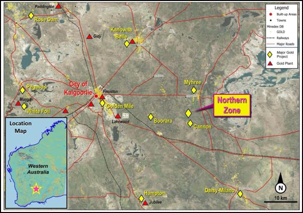
Figure 1: Location of Northern Zone project showing proximity to the Kalgoorlie "Super Pit", Golden Mile/Fimiston.
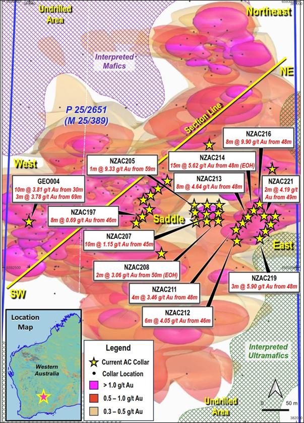
Figure 2: Drill collar plan and selected significant drill intercepts. The composite gold grade interpolant contours are derived from all the Riversgold/Oracle drilling results up to March 2026.
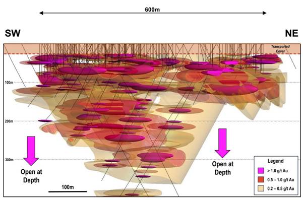
Figure 3: Cross-section of 3D Leapfrog software model. The interpretation illustrates composite gold grade shells derived from all of the Riversgold/Oracle gold intercepts reported so far. The updated interpolant model is constrained via a 50m buffer to all the Riversgold/Oracle drill hole traces that have been drilled at Northern Zone since 2021, up to March 2026. Refer to Figure 2 Drill collar plan for the location of the section line.
APPENDIX 1: Drilling Information
Table 1: Northern Zone Significant Intercepts from all air core drill rig drillholes
|
Hole ID |
From (m) |
To (m) |
Width (m) |
Au g/t |
Intercept |
|
NZAC196 |
57 |
60 |
3 |
0.76 |
3m @ 0.76g/t Au from 57m, NZAC196 |
|
NZAC197 |
46 |
54 |
8 |
0.69 |
8m @ 0.69g/t Au from 46m, NZAC197 |
|
NZAC198 |
No significant intercepts |
||||
|
NZAC199 |
No significant intercepts |
||||
|
NZAC200 |
No significant intercepts |
||||
|
NZAC201 |
No significant intercepts |
||||
|
NZAC202 |
45 |
46 |
1 |
1.64 |
1m @ 1.64g/t Au from 45m, NZAC202 |
|
NZAC203 |
41 |
42 |
1 |
1.03 |
4m @ 1.03g/t Au from 41m, NZAC203 |
|
NZAC204 |
49 |
50 |
1 |
1.64 |
1m @ 1.64g/t Au from 49m, NZAC204 |
|
NZAC205 |
59 |
60 |
1 |
9.33 |
1m @ 9.33g/t Au from 59m, NZAC205 |
|
NZAC206 |
67 |
68 |
1 |
1.94 |
1m @ 1.94g/t Au from 67m (EOH), NZAC206 |
|
NZAC207 |
45 |
55 |
10 |
1.15 |
10m @ 1.15g/t Au from 45m, NZAC207 |
|
NZAC208 |
50 |
52 |
2 |
3.06 |
2m @ 3.06g/t Au from 50m (EOH), NZAC208 |
|
NZAC209 |
No significant intercepts |
||||
|
NZAC210 |
48 |
49 |
1 |
1.15 |
1m @ 1.15g/t Au from 48m, NZAC210 |
|
NZAC211 |
48 |
52 |
4 |
3.46 |
4m @ 3.46g/t Au from 48m, NZAC211 |
|
NZAC212 |
46 |
52 |
6 |
4.05 |
6m @ 4.05g/t Au from 46m, NZAC212 |
|
NZAC213 |
48 |
56 |
8 |
4.64 |
8m @ 4.64g/t Au from 48m, NZAC213 |
|
NZAC214 |
48 |
63 |
15 |
5.62 |
15m @ 5.62g/t Au from 48m (EOH), NZAC214 |
|
NZAC215 |
49 |
50 |
1 |
3.79 |
1m @ 3.79g/t Au from 49m, NZAC215 |
|
NZAC216 |
48 |
56 |
8 |
9.9 |
8m @ 9.90g/t Au from 48m, NZAC216 |
|
NZAC217 |
No significant intercepts |
||||
|
NZAC218 |
47 |
49 |
2 |
1.45 |
2m @ 1.45g/t Au from 47m, NZAC218 |
|
NZAC219 |
48 |
51 |
3 |
5.9 |
3m @ 5.90g/t Au from 48m, NZAC219 |
|
NZAC220 |
51 |
52 |
1 |
1.34 |
1m @ 1.34g/t Au from 51m, NZAC220 |
|
NZAC221 |
49 |
51 |
2 |
4.19 |
2m @ 4.19g/t Au from 49m, NZAC221 |
|
GEO001 |
No significant intercepts |
||||
|
GEO002 |
No significant intercepts |
||||
|
GEO004 |
30 |
40 |
10 |
3.81 |
10m @ 3.81g/t Au from 30m, GEO004 |
|
GEO004 |
69 |
72 |
3 |
3.78 |
3m @ 3.78g/t Au from 69m, GEO004 |
|
WB001 |
No significant intercepts |
||||
Table 2: Northern Zone Drill Collar Locations
|
Hole ID |
Type |
MGA_E |
MGA_N |
Elevation (m) |
Total Depth (m) |
Dip (o) |
AZM_MGA |
Date |
|
NZAC195 |
AC |
381700 |
6592583 |
356.11 |
63 |
0 |
-90 |
10-02-26 |
|
NZAC196 |
AC |
381712 |
6592596 |
356.16 |
63 |
0 |
-90 |
10-02-26 |
|
NZAC197 |
AC |
381722 |
6592610 |
356.22 |
64 |
0 |
-90 |
10-02-26 |
|
NZAC198 |
AC |
381715 |
6592627 |
356.32 |
65 |
0 |
-90 |
13-02-26 |
|
NZAC199 |
AC |
381728 |
6592636 |
356.38 |
71 |
0 |
-90 |
13-02-26 |
|
NZAC200 |
AC |
381742 |
6592647 |
356.45 |
73 |
0 |
-90 |
14-02-26 |
|
NZAC201 |
AC |
381756 |
6592662 |
356.8 |
73 |
0 |
-90 |
17-02-26 |
|
NZAC202 |
AC |
381808 |
6592617 |
356.7 |
71 |
0 |
-90 |
17-02-26 |
|
NZAC203 |
AC |
381811 |
6592604 |
356.72 |
70 |
0 |
-90 |
18-02-26 |
|
NZAC204 |
AC |
381812 |
6592587 |
356.76 |
63 |
0 |
-90 |
18-02-26 |
|
NZAC205 |
AC |
381833 |
6592601 |
356.77 |
68 |
0 |
-90 |
18-02-26 |
|
NZAC206 |
AC |
381854 |
6592616 |
356.76 |
68 |
0 |
-90 |
19-02-26 |
|
NZAC207 |
AC |
381853 |
6592603 |
356.54 |
66 |
0 |
-90 |
15-02-26 |
|
NZAC208 |
AC |
381853 |
6592590 |
356.58 |
51 |
0 |
-90 |
16-02-26 |
|
NZAC209 |
AC |
381832 |
6592616 |
356.46 |
70 |
0 |
-90 |
14-02-26 |
|
NZAC210 |
AC |
381831 |
6592590 |
356.37 |
67 |
0 |
-90 |
15-02-26 |
|
NZAC211 |
AC |
381888 |
6592571 |
356.43 |
62 |
0 |
-90 |
17-02-26 |
|
NZAC212 |
AC |
381888 |
6592550 |
356.44 |
57 |
0 |
-90 |
16-02-26 |
|
NZAC213 |
AC |
381901 |
6592584 |
356.54 |
61 |
0 |
-90 |
14-02-26 |
|
NZAC214 |
AC |
381910 |
6592596 |
356.68 |
63 |
0 |
-90 |
16-02-26 |
|
NZAC215 |
AC |
381923 |
6592607 |
356.81 |
60 |
0 |
-90 |
15-02-26 |
|
NZAC216 |
AC |
381931 |
6592618 |
356.27 |
62 |
0 |
-90 |
13-02-26 |
|
NZAC217 |
AC |
381933 |
6592555 |
356.98 |
59 |
0 |
-90 |
19-02-26 |
|
NZAC218 |
AC |
381943 |
6592570 |
356.89 |
59 |
0 |
-90 |
20-02-26 |
|
NZAC219 |
AC |
381951 |
6592581 |
356.98 |
57 |
0 |
-90 |
20-02-26 |
|
NZAC220 |
AC |
381959 |
6592595 |
357 |
66 |
0 |
-90 |
19-02-26 |
|
NZAC221 |
AC |
381942 |
6592598 |
356.88 |
61 |
0 |
-90 |
20-02-26 |
|
GEO001 |
AC |
381836 |
6592731 |
356.75 |
74 |
0 |
-90 |
22-02-26 |
|
GEO002 |
AC |
381747 |
6592527 |
356.25 |
56 |
0 |
-90 |
21-02-26 |
|
GEO004 |
AC |
381498 |
6592586 |
356.85 |
78 |
0 |
-90 |
21-02-26 |
|
WB001 |
AC |
381956 |
6592684 |
356.7 |
72 |
0 |
-90 |
22-02-26 |
Table 3: Northern Zone assay results above 0.3 g/t Au from all air core drill holes
|
Hole ID |
Depth From (m) |
Depth To (m) |
Width (m) |
Au ppm |
|
NZAC195 |
36 |
37 |
1 |
0.4 |
|
NZAC196 |
31 |
32 |
1 |
0.55 |
|
NZAC196 |
35 |
36 |
1 |
0.3 |
|
NZAC196 |
36 |
37 |
1 |
0.7 |
|
NZAC196 |
54 |
55 |
1 |
0.35 |
|
NZAC196 |
57 |
58 |
1 |
0.5 |
|
NZAC196 |
58 |
59 |
1 |
1.37 |
|
NZAC196 |
59 |
60 |
1 |
0.42 |
|
NZAC197 |
46 |
47 |
1 |
2.56 |
|
NZAC197 |
51 |
52 |
1 |
1.43 |
|
NZAC197 |
52 |
53 |
1 |
0.69 |
|
NZAC197 |
53 |
54 |
1 |
0.3 |
|
NZAC197 |
63 |
64 |
1 |
0.39 |
|
NZAC198 |
46 |
47 |
1 |
0.45 |
|
NZAC200 |
50 |
51 |
1 |
0.33 |
|
NZAC201 |
43 |
44 |
1 |
0.3 |
|
NZAC202 |
45 |
46 |
1 |
1.64 |
|
NZAC203 |
41 |
42 |
1 |
1.1 |
|
NZAC203 |
44 |
45 |
1 |
2.91 |
|
NZAC204 |
44 |
45 |
1 |
0.37 |
|
NZAC204 |
49 |
50 |
1 |
1.64 |
|
NZAC205 |
40 |
41 |
1 |
0.6 |
|
NZAC205 |
47 |
48 |
1 |
0.5 |
|
NZAC205 |
49 |
50 |
1 |
0.57 |
|
NZAC205 |
58 |
59 |
1 |
9.33 |
|
NZAC206 |
33 |
34 |
1 |
0.42 |
|
NZAC206 |
67 |
68 |
1 |
1.94 |
|
NZAC207 |
45 |
46 |
1 |
0.83 |
|
NZAC207 |
49 |
50 |
1 |
0.64 |
|
NZAC207 |
51 |
52 |
1 |
9.23 |
|
NZAC207 |
54 |
55 |
1 |
0.33 |
|
NZAC208 |
49 |
50 |
1 |
1.02 |
|
NZAC208 |
50 |
51 |
1 |
5.09 |
|
NZAC209 |
44 |
45 |
1 |
0.75 |
|
NZAC209 |
49 |
50 |
1 |
0.53 |
|
NZAC210 |
45 |
46 |
1 |
0.31 |
|
NZAC210 |
48 |
49 |
1 |
1.15 |
|
NZAC210 |
49 |
50 |
1 |
0.52 |
|
NZAC211 |
48 |
49 |
1 |
1.09 |
|
NZAC211 |
50 |
51 |
1 |
11.43 |
|
NZAC211 |
51 |
52 |
1 |
1.27 |
|
NZAC212 |
46 |
47 |
1 |
1.86 |
|
NZAC212 |
48 |
49 |
1 |
2.88 |
|
NZAC212 |
49 |
50 |
1 |
3.64 |
|
NZAC212 |
50 |
51 |
1 |
15.08 |
|
NZAC212 |
51 |
52 |
1 |
0.78 |
|
NZAC213 |
42 |
43 |
1 |
0.56 |
|
NZAC213 |
48 |
49 |
1 |
0.57 |
|
NZAC213 |
50 |
51 |
1 |
1.54 |
|
NZAC213 |
51 |
52 |
1 |
32.12 |
|
NZAC213 |
52 |
53 |
1 |
0.8 |
|
NZAC213 |
53 |
54 |
1 |
0.93 |
|
NZAC213 |
55 |
56 |
1 |
0.96 |
|
NZAC214 |
48 |
49 |
1 |
0.42 |
|
NZAC214 |
49 |
50 |
1 |
0.44 |
|
NZAC214 |
50 |
51 |
1 |
0.94 |
|
NZAC214 |
51 |
52 |
1 |
68.12 |
|
NZAC214 |
52 |
53 |
1 |
7.77 |
|
NZAC214 |
53 |
54 |
1 |
0.97 |
|
NZAC214 |
54 |
55 |
1 |
0.97 |
|
NZAC214 |
55 |
56 |
1 |
0.46 |
|
NZAC214 |
56 |
57 |
1 |
0.62 |
|
NZAC214 |
57 |
58 |
1 |
0.3 |
|
NZAC214 |
60 |
61 |
1 |
0.68 |
|
NZAC214 |
61 |
62 |
1 |
1.5 |
|
NZAC214 |
62 |
63 |
1 |
0.6 |
|
NZAC215 |
37 |
38 |
1 |
0.47 |
|
NZAC215 |
49 |
50 |
1 |
3.79 |
|
NZAC215 |
57 |
58 |
1 |
0.39 |
|
NZAC216 |
48 |
49 |
1 |
0.47 |
|
NZAC216 |
50 |
51 |
1 |
3.82 |
|
NZAC216 |
51 |
52 |
1 |
71 |
|
NZAC216 |
52 |
53 |
1 |
0.99 |
|
NZAC216 |
53 |
54 |
1 |
1.83 |
|
NZAC216 |
55 |
56 |
1 |
0.78 |
|
NZAC217 |
44 |
45 |
1 |
0.6 |
|
NZAC218 |
47 |
48 |
1 |
1.77 |
|
NZAC218 |
48 |
49 |
1 |
1.13 |
|
NZAC219 |
48 |
49 |
1 |
15.87 |
|
NZAC219 |
49 |
50 |
1 |
0.42 |
|
NZAC219 |
50 |
51 |
1 |
1.41 |
|
NZAC220 |
48 |
49 |
1 |
0.36 |
|
NZAC220 |
49 |
50 |
1 |
0.4 |
|
NZAC220 |
51 |
52 |
1 |
1.34 |
|
NZAC221 |
37 |
38 |
1 |
0.47 |
|
NZAC221 |
42 |
43 |
1 |
0.41 |
|
NZAC221 |
49 |
50 |
1 |
6.14 |
|
NZAC221 |
50 |
51 |
1 |
2.24 |
|
GEO004 |
30 |
31 |
1 |
1.85 |
|
GEO004 |
31 |
32 |
1 |
0.67 |
|
GEO004 |
32 |
33 |
1 |
16.67 |
|
GEO004 |
33 |
34 |
1 |
8.15 |
|
GEO004 |
34 |
35 |
1 |
1.24 |
|
GEO004 |
35 |
36 |
1 |
4.21 |
|
GEO004 |
36 |
37 |
1 |
1.27 |
|
GEO004 |
38 |
39 |
1 |
3.36 |
|
GEO004 |
39 |
40 |
1 |
0.39 |
|
GEO004 |
56 |
57 |
1 |
0.7 |
|
GEO004 |
57 |
58 |
1 |
0.46 |
|
GEO004 |
58 |
59 |
1 |
0.73 |
|
GEO004 |
59 |
60 |
1 |
0.31 |
|
GEO004 |
69 |
70 |
1 |
8.55 |
|
GEO004 |
70 |
71 |
1 |
2.36 |
|
GEO004 |
71 |
72 |
1 |
0.43 |
|
WB001 |
40 |
41 |
1 |
0.39 |
|
WB001 |
44 |
45 |
1 |
0.31 |
|
WB001 |
47 |
48 |
1 |
0.61 |
The following Tables are provided to ensure compliance with the JORC Code (2012 Edition) requirements for the reporting of Exploration Results at Northern Zone.
Section 1: Sampling Techniques and Data
(Criteria in this section applies to all succeeding sections)
|
Criteria |
JORC Code explanation |
Commentary |
|
Sampling techniques |
Nature and quality of sampling (e.g. cut channels, random chips, or specific specialised industry standard measurement tools appropriate to the minerals under investigation, such as down hole gamma sondes, or handheld XRF instruments, etc.). These examples should not be taken as limiting the broad meaning of sampling. Include reference to measures taken to ensure sample representivity and the appropriate calibration of any measurement tools or systems used. Aspects of the determination of mineralisation that are Material to the Public Report. In cases where 'industry standard' work has been done this would be relatively simple (e.g. 'reverse circulation drilling was used to obtain 1 m samples from which 3 kg was pulverised to produce a 30 g charge for fire assay'). In other cases, more explanation may be required, such as where there is coarse gold that has inherent sampling problems. Unusual commodities or mineralisation types (eg submarine nodules) may warrant disclosure of detailed information. |
Every metre drilled was placed on the ground. 6m composites were collected using a scoop method of sampling the coarse reject sample for the first 24m. 1m sampling using a rifle splitter was trialled on the clays, from 24m, with sampling deemed to create a high degree risk of smearing. The clays are not wet, but have a damp characteristic. A large metal scoop was used to sample between 70-90% of material from each metre drilled, to total between 2-3kg samples. Standard reference material, sample duplicates and blanks, were undertaken at 25m sample intervals. Samples were sent to the laboratory for crushing, splitting and analysis. Analysis was undertaken by Jinnings laboratories (Kalgoorlie) for gold assay by 50g fire assay. |
|
Drilling techniques |
Drill type (e.g. core, reverse circulation, open-hole hammer, rotary air blast, auger, Bangka, sonic, etc.) and details (e.g. core diameter, triple or standard tube, depth of diamond tails, face-sampling bit or other type, whether core is oriented and if so, by what method, etc.). |
Australian Aircore Drilling completed the programme using a blade to refusal. |
|
Drill sample recovery |
Method of recording and assessing core and chip sample recoveries and results assessed. Measures taken to maximise sample recovery and ensure representative nature of the samples. Whether a relationship exists between sample recovery and grade and whether sample bias may have occurred due to preferential loss/gain of fine/coarse material. |
Drill recovery was routinely recorded via estimation of the comparative percentage of the volume of the sample bag by the company geologist. The sample recovery was deemed excellent for representative assays. The cyclone was cleaned or checked every 6m. |
|
Logging |
Whether core and chip samples have been geologically and geotechnically logged to a level of detail to support appropriate Mineral Resource estimation, mining studies and metallurgical studies. Whether logging is qualitative or quantitative in nature. Core (or costean, channel, etc.) photography. The total length and percentage of the relevant intersections logged. |
All holes have been geologically logged for lithology, mineralisation and weathering. As well as whether dry, damp or wet. Logging is quantitative for presence of quartz veins. All other logging is qualitative. A brief description of each drilling sample was recorded and a permanent record has been collected and stored in chip trays for reference. |
|
Sub-sampling techniques and sample preparation |
If core, whether cut or sawn and whether quarter, half or all core taken. If non-core, whether riffled, tube sampled, rotary split, etc. and whether sampled wet or dry. For all sample types, the nature, quality and appropriateness of the sample preparation technique. Quality control procedures adopted for all sub-sampling stages to maximise representivity of samples. Measures taken to ensure that the sampling is representative of the in-situ material collected, including for instance results for field duplicate/second-half sampling. Whether sample sizes are appropriate to the grain size of the material being sampled. |
1m sampling using a rifle splitter was trialled on the clays, from 24m, with sampling deemed to create a high degree risk of smearing. The clays are not wet, but have a damp characteristic. A large metal scoop was used to sample between 70-90% of material from each metre drilled, to total between 2-3kg samples. Standard reference material, sample duplicates and blanks, were undertaken at 25m sample intervals. Samples were sent to the laboratory for crushing, splitting and analysis. The use of fire assay with 50g charge for all AC drilling provides a level of confidence in the assay database. The sampling and assaying are considered representative of the in-situ material. The sample size of 2-3 kilograms is appropriate and representative of the grain size and mineralisation style of the deposit. |
|
Quality of assay data and laboratory tests |
The nature, quality and appropriateness of the assaying and laboratory procedures used and whether the technique is considered partial or total. For geophysical tools, spectrometers, handheld XRF instruments, etc., the parameters used in determining the analysis including instrument make and model, reading times, calibrations factors applied and their derivation, etc. Nature of quality control procedures adopted (e.g. standards, blanks, duplicates, external laboratory checks) and whether acceptable levels of accuracy (i.e. lack of bias) and precision have been established. |
Jinnings (Kalgoorlie) were used for all analysis of drill samples submitted by Riversgold. The laboratory techniques below are for all samples submitted to Jinnings and are considered appropriate for the style of mineralisation defined within the Northern Zone project area: Samples above 3kg were riffle split. Pulverise to 95% passing 75 microns 50-gram Fire Assay (FA50A) - Au Duplicates, Standards and Blanks were used for external laboratory checks by RGL |
|
Verification of sampling and assaying |
The verification of significant intersections by either independent or alternative company personnel. The use of twinned holes. Documentation of primary data, data entry procedures, data verification, data storage (physical and electronic) protocols. Discuss any adjustment to assay data. |
Intercepts were reviewed by 2 company personnel. |
|
Location of data points |
Accuracy and quality of surveys used to locate drill holes (collar and down-hole surveys), trenches, mine workings and other locations used in Mineral Resource estimation. Specification of the grid system used. Quality and adequacy of topographic control. |
The collar position of each hole has been marked out with a Garmin Inreach Explorer+ hand held GPS, and will be picked up by Spectrum Surveys (Kalgoorlie) using a DGPS. |
|
Data spacing and distribution |
Data spacing for reporting of Exploration Results. Whether the data spacing and distribution is sufficient to establish the degree of geological and grade continuity appropriate for the Mineral Resource and Ore Reserve estimation procedure(s) and classifications applied. Whether sample compositing has been applied. |
The holes were drilled on a nominal Northeast-Southwest 20m spacing on traverses 15-20m apart. |
|
Orientation of data in relation to geological structure |
Whether the orientation of sampling achieves unbiased sampling of possible structures and the extent to which this is known, considering the deposit type. If the relationship between the drilling orientation and the orientation of key mineralised structures is considered to have introduced a sampling bias, this should be assessed and reported if material. |
Based on logging of diamond core the drill holes appear to be orientated perpendicular to strike and dip of the main mineralised structures. An interpreted fault though the middle of the mineralisation may have caused some displacement. |
|
Sample security |
The measures taken to ensure sample security. |
Company personnel delivered samples to Jinnings Kalgoorlie where they were submitted for assay. |
|
Audits or reviews |
The results of any audits or reviews of sampling techniques and data. |
Data reviews will be conducted on completion of further drilling. |
Section 2: Reporting of Exploration Results
(Criteria listed in the preceding section also apply to this section)
|
Criteria |
JORC Code explanation |
Commentary |
|
Mineral tenement and land tenure status |
Type, reference name/number, location and ownership including agreements or material issues with third parties such as joint ventures, partnerships, overriding royalties, native title interests, historical sites, wilderness or national park and environmental settings. The security of the tenure held at the time of reporting along with any known impediments to obtaining a licence to operate in the area. |
The Northern Zone Project is comprised of one granted prospecting licence (P25/2651) which covers an area of 82 hectares, and is held in the name of Riversgold (Australia) Pty Ltd 80/100, Oracle Gold (WA) Pty Ltd 20/100. The JV documents are to be formalised. Oracle currently contribute pro-rata at 20% of all costs, and have the option to dilute. |
|
Exploration done by other parties |
Acknowledgment and appraisal of exploration by other parties. |
The majority of previous exploration in the area was by Northern Mining during 2007 to 2012 under the Blair North project, multiple small resource areas were identified at the George's Reward area to the south of P25/2651. Numerous gold intersections were recorded. |
|
Geology |
Deposit type, geological setting and style of mineralisation. |
The deposit sought is Intrusion Related Gold System (IRGS) style of mineral deposit. Northern Zone is hosted within a porphyry unit (Tonalite-Trondhjemite Intrusion, TTI), with high background gold and horizontal gold mineralised units within the TTI unit. The Northern Zone Project sits within the Canon Shear or fault zone, with further drilling required to define the limits of mineralisation identified to date. |
|
Drill hole Information |
A summary of all information material to the understanding of the exploration results including a tabulation of the following information for all Material drill holes: easting and northing of the drill hole collar elevation or RL (Reduced Level - elevation above sea level in metres) of the drill hole collar dip and azimuth of the hole down hole length and interception depth hole length. If the exclusion of this information is justified on the basis that the information is not Material and this exclusion does not detract from the understanding of the report, the Competent Person should clearly explain why this is the case. |
Refer to Tables and Figures within the body of the release. |
|
Data aggregation methods |
In reporting Exploration Results, weighting averaging techniques, maximum and/or minimum grade truncations (e.g. cutting of high grades) and cut-off grades are usually Material and should be stated. Where aggregate intercepts incorporate short lengths of high-grade results and longer lengths of low-grade results, the procedure used for such aggregation should be stated and some typical examples of such aggregations should be shown in detail. The assumptions used for any reporting of metal equivalent values should be clearly stated. |
Intersections are weighted average grades based on a 0.001 g/t Au cut-off with unlimited waste zones but with a targeted grade of 0.4-0.6g/t Au. |
|
Relationship between mineralisation widths and intercept lengths |
These relationships are particularly important in the reporting of Exploration Results. If the geometry of the mineralisation with respect to the drill hole angle is known, its nature should be reported. If it is not known and only the down hole lengths are reported, there should be a clear statement to this effect (eg 'down hole length, true width not known'). |
The diamond drilling programme in 2023 confirmed the apparent widths of mineralisation as being perpendicular to foliation and veining. Step out RC drilling to be the same as the diamond drilling. Mineralisation has been determined from structural logging to be horizontal and vertical drilling is therefore true width drilling. |
|
Diagrams |
Appropriate maps and sections (with scales) and tabulations of intercepts should be included for any significant discovery being reported These should include, but not be limited to, a plan view of drill hole collar locations and appropriate sectional views. |
See body of the announcement for relevant diagrams and photos. Figure 3: Cross-section of 3D Leapfrog software model. The interpretation illustrates gold grade shells, derived from all of the Riversgold/Oracle gold grades (au ppm) reported to the ASX to March 2026. The model is constrained via a 50m buffer to all the Riversgold/Oracle drill hole traces that have been drilled at Northern Zone since 2021. Refer to Figure 2 Drill collar plan for the location of the section line. Figure 2: Plan view of Leapfrog software model. The interpretation illustrates gold grade shells, derived from all of the Riversgold/Oracle gold grades (au ppm) reported to March 2026. The figure illustrates the position of the Cross-section in Figure 3, and the location of the significant intercepts reported from the most recent AC drilling programme. There are multiple areas that remain undrilled as noted on the diagram, with mineralisation yet to be confirmed. |
|
Balanced reporting |
Where comprehensive reporting of all Exploration Results is not practicable, representative reporting of both low and high grades and/or widths should be practiced to avoid misleading reporting of Exploration Results. |
The reporting of exploration results is considered balanced by the competent person. |
|
Other substantive exploration data |
Other exploration data, if meaningful and material, should be reported including (but not limited to): geological observations; geophysical survey results; geochemical survey results; bulk samples - size and method of treatment; metallurgical test results; bulk density, groundwater, geotechnical and rock characteristics; potential deleterious or contaminating substances. |
See body of the announcement. |
|
Further work |
The nature and scale of planned further work (e.g. tests for lateral extensions or depth extensions or large-scale step-out drilling). Diagrams clearly highlighting the areas of possible extensions, including the main geological interpretations and future drilling areas, provided this information is not commercially sensitive. |
· Follow up phases of drilling to further test open mineralisation, laterally and at depth. · Complete a Mine Development and Closure Plan (MDCP) |
RNS may use your IP address to confirm compliance with the terms and conditions, to analyse how you engage with the information contained in this communication, and to share such analysis on an anonymised basis with others as part of our commercial services. For further information about how RNS and the London Stock Exchange use the personal data you provide us, please see our Privacy Policy.

Latest directors dealings
- 7 hours ago Gran Tierra Energy Inc. (CDI)
- 8 hours ago Polar Capital Holdings
- 8 hours ago PZ Cussons
- 9 hours ago Grainger
- 9 hours ago Molten Ventures VCT