
NWQ Copper Project – Big One Follow-Up Program
Summary by AI BETAClose X

New Frontier Minerals Limited / Index: ASX & LSE / Epic: NFM / Sector: Industrial Metals and Mining
11 November 2026
New Frontier Minerals Limited
(“NFM” or the "Company")
NWQ Copper Project – Big One Follow-Up Program Advances Southwest Drill Target
New Frontier Minerals Ltd (LSE and ASX: NFM), is pleased to provide an update on structural mapping and rock chip sampling completed at the Big One Deposit within its NWQ Copper Project (“NWQ” or “the Project”) in North-West Queensland, following a field program conducted between 28 September and 1 October 2026.
Highlights
• As part of the Company’s systematic follow-up of the Big One along-strike surface anomaly, NFM completed structural mapping and rock chip sampling at a historical costean approximately 400m southwest of Big One Pit 1, along strike of the mineralised trachyte dyke and fault that host the Big One Mineral Resource
• In situ rock chip results of 1.30% CuO and stockpile sampling returned up to 7.76% CuO; with samples from the costean returning up to 1.67% CuO
• Copper oxide minerals were observed within altered trachyte dyke and adjacent haematite-altered sedimentary rocks along the shear
• Structural measurements in the costean (approximately 80° towards 060°) are consistent with the mineralised fault structure in Big One Pits 1, 2 and 3, supporting the Company’s interpretation that the mineralised structure continues along strike beyond the historical pits4
• The costean area lies within a heritage cleared area (Kalkadoon, September 2020) and can be included as a target in the Company’s next drill program at Big One
The program followed up the Company’s previous surface sampling and mapping at Big One, which defined a copper anomaly indicating that mineralisation extends southwest approximately 400m along strike from the historical workings from Pit 14. Copper mineralisation at Big One is hosted along a north-east trending fault intruded by a trachyte dyke, with malachite staining observed along at least 600m of strike, of which approximately 200m has been exploited by historical open pits4.
The 2026 field program focused on a historical costean approximately 400m southwest of Big One Pit 1, located on this structural trend. Detailed structural mapping recorded the orientation of the in-situ shear zone exposed in the costean, and six rock chip samples were collected from the costean, an adjacent stockpile and near Pit 1 for laboratory analysis. The work was designed to further characterise the mineralised structure beyond the historical pits and to refine targeting for the Company’s next drill program at Big One.
Chairman Gerrard Hall commented: “This program was designed to follow up the copper anomaly previously defined southwest of the pits. The structural readings in the costean line up with the fault that hosts the Big One Resource, and the in-situ samples along the shear returned up to 1.30% CuO. This part of the structure has never been drilled and sits within an area which has already received heritage clearance.”
BIG ONE SOUTHWEST COSTEAN – STRUCTURE AND GEOLOGY
The New Frontier Minerals geological team visited Morella Station and the Big One Deposit between 28 September and 1 October 2026. Work comprised structural mapping of a historical costean southwest of Big One Pit 1 and rock chip sampling (Figure 1).
The historical costean is located approximately 400m southwest of Big One Pit 1 (main pit). It is approximately 1m deep and exposes an in-situ shear zone. The dominant shearing plane was measured at approximately 80° towards 060°, consistent with the mineralised fault structure in Big One Pits 1, 2 and 3.
Mineralisation in the costean is hosted primarily in a trachyte dyke, extending partly into the adjacent hematite-altered sedimentary unit (interpreted as greywacke, siltstone and quartzite). The altered zone along the shear shows white to yellow argillic alteration with a bleached appearance and vesicles infilled with malachite.
The consistent orientation supports the Company’s interpretation that the Big One copper-bearing fault continues along strike southwest of the main pit, largely under cover4. This part of the structure has not been drill-tested. The costean lies within an area heritage cleared by the Kalkadoon in September 2020 (Figure 2).
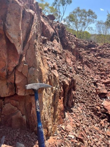
Figure 1: Shear zone exposed in the historical costean approximately 400m southwest of Big One Pit 1, showing bleached, vesicular altered trachyte (Source: NFM)
ROCK CHIP SAMPLE LOCATIONS AND RESULTS
Six rock chip samples (BORS001–BORS006) were collected on 1 October 2026. Four were taken from the costean, two in situ along the dominant shearing plane (BORS001 and BORS002) and two from costean rubble away from the shear (BORS004 and BORS005); one (BORS003) was taken from a stockpile immediately east of the costean; and one (BORS006) northeast of the Big One Pit 1. Sample locations are shown in Figure 2 and assay results are reported in Appendix 22.
BORS003 is a selective sample of stockpiled material that is not in situ. Results should not be considered representative of the grade of the Big One Deposit or the interpreted southwest extension.
Rock chip sampling returned up to 7.76% CuO from the selective stockpile sample BORS003. Samples from the costean returned up to 1.67% CuO (BORS004, costean rubble), with in situ samples along the shear returning up to 1.30% CuO (BORS002). BORS006, collected from a suspected gossan outcrop northeast of Pit 1 beyond the current resource limit, returned 0.15% CuO and a significant 594ppm Co. Results for all six samples are presented in Appendix 22.
Copper oxide (CuO) values are calculated from total copper assays by multiplying by a stoichiometric factor of 1.2518 (the ratio of the molecular weight of CuO to the atomic weight of Cu). They express total copper in oxide form and do not represent the proportion of copper hosted in oxide minerals.
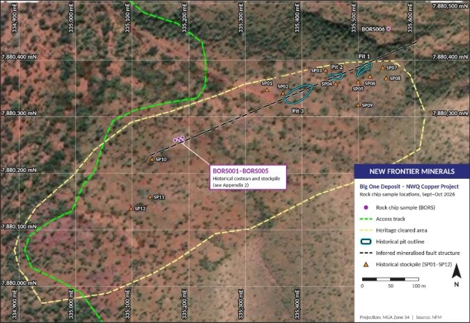
Figure 2: Big One rock chip sample location (BORS001–BORS006), historical pits, stockpiles, access tracks and heritage cleared area. Coordinate system MGA Zone 54 (Source: NFM)
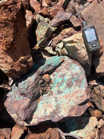
Figure 3: Malachite and chrysocolla on hematite-altered rock, Big One (Source: NFM)
BIG ONE DEPOSIT OVERVIEW
The Big One Deposit is located approximately 90km north of Mt Kelly processing facility, within EPM 26574 (Figure 4). The Big One deposit resides within Mining Lease Application ML100479 and hosts a JORC (2012) Mineral Resource Estimate of 2.1Mt @ 1.1% Cu for 21,886t contained copper (0.45% Cu cut-off), predominantly in the Inferred category1.
REGIONAL AND DEPOSIT GEOLOGY
The NWQ Copper Project lies within the Mt Oxide Domain of the Proterozoic Mt Isa Inlier, straddling the Lawn Hill Platform and the Leichhardt River Fault Trough. The local geology comprises the Surprise Creek and Quilalar Formations (feldspathic quartzites, conglomerates, arkosic grits, shales, siltstones and minor dolomites and limestones) and dolomitic siltstones of the Lochness Formation. The area is cut by major north-north-east trending fault zones, and nearby copper deposits such as Mt Oxide and Mt Gordon are fault-related breccia and replacement systems4.
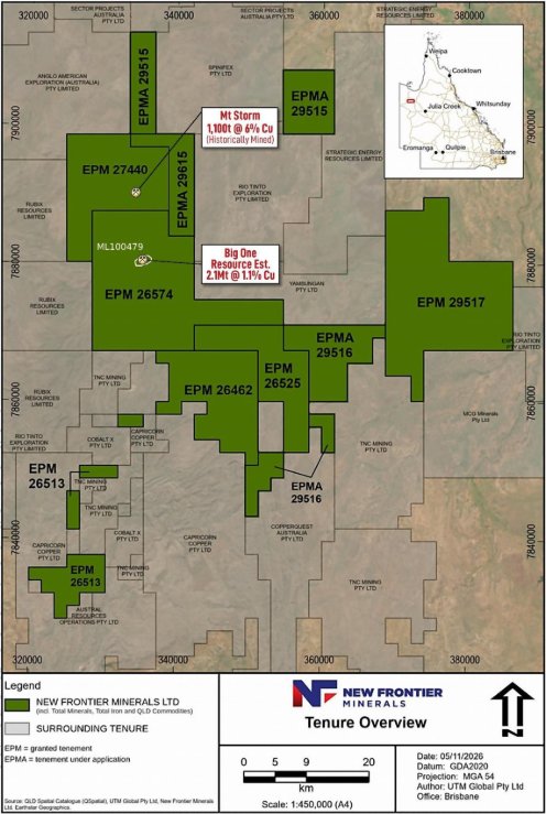
Figure 4: NWQ Copper Project tenure overview.
At Big One, copper mineralisation is hosted along a north-east trending fault (approximately 062°–242°) intruded by a vertical to near-vertical (~85°) trachyte dyke, with a true width of up to 9m at surface. The dyke is flanked by fractured, sheared and brecciated sedimentary rocks, and the surrounding strata dip gently (5–30°) to the north. Malachite staining has been observed along at least 600m of strike, of which historical open pits have exploited approximately 200m4. Mapping by the Company in 2020 recorded the fault through Pits 1–3 as sub-vertical to steeply dipping, with malachite, azurite, bornite and possible cuprite within the fault breccia zone3.
The Big One Mineral Resource commences from surface and comprises both oxidised and fresh material (from approximately 40m depth), with mineralisation open to the east, north and down dip1. Previous surface sampling and mapping by the Company defined a copper anomaly indicating that mineralisation extends southwest along strike from the historical workings, with potential for further mineralisation south and east of the line of lode4.
The historical costean lies on this structural trend, southwest of the historical pits, within the area identified by the Company’s previous work as prospective along strike4. The current program adds detailed structural measurements and laboratory assays from the costean, which are consistent with the structure and style of mineralisation at the known deposit.
NEXT STEPS
New Frontier’s forthcoming Big One work program includes:
- Integrate the structural measurements and assay results into the Big One geological model to test continuity between Pit 1 and the costean
- Undertake further geophysical work (possibly infill IP lines or Mobile-MT) along the mineralised fault structure to define drill targets
- Include the costean area as a target in the Company’s next drill program at Big One, alongside Mineral Resource infill targets1
ENDS
This announcement was approved for release by the Board of New Frontier Minerals Limited.
For further information please contact:
|
New Frontier Minerals Limited |
+61 8 6558 0886 |
|
Gerrard Hall (UK), Chairman |
|
|
|
|
|
St Brides Partners Ltd (Financial PR) |
+44 (0)20 7236 1177 |
|
Ana Ribeiro and Charlotte Page |
|
REFERENCES
- CCZ ASX Release – “Castillo Provides Maiden Mineral Resource Estimate for Big One Deposit”, 28 February 2022.
- Australian Laboratory Services Pty Ltd (ALS Perth) – Certificate of Analysis PH26377215, finalised 4 November 2026.
- Xplore Resources Pty Ltd, 2020 – “Site Visit to Big One prospect by C. Tedman-Jones and B. Bagci with landholder Ed Butterworth, 5th August 2020” (unpublished report prepared for Castillo Copper Limited).
- CCZ ASX Release – “Surface Assays Increase Priority Copper Target Area at Big One Deposit”, 7 October 2024.
About New Frontier Minerals
New Frontier Minerals Limited is an Australian-based focused explorer, exploring for the critical minerals and base metals required to power a more electrified and sustainable future. New Frontier holds a strategic portfolio of rare earth, niobium and copper assets in Australia and Canada, which includes the Harts Range Heavy Rare Earths and Niobium Project in the Northern Territory, the NWQ Copper Project in Queensland. Other interests include the Pomme REE Project, situated in Quebec, Canada. These commodities are expected to play an increasingly important role in supporting global decarbonisation, energy security and technological advancement.
Competent Persons Statement
The scientific and technical information in this announcement, which relates to exploration results and the geology of the prospects described, is based on information compiled and approved for release by Mark Biggs. Mark Biggs is a Member of The Australasian Institute of Mining and Metallurgy (AusIMM Member # 107188) and meets the requirements of a Competent Person as defined by the 2012 Edition of the Australasian Code for Reporting of Exploration Results, Mineral Resources and Ore Reserves (JORC Code 2012 Edition).
Mark Biggs has 35 years of experience relevant to the mineralisation styles described in this announcement, as well as expertise in the quality and potential exploration methods for the prospects under consideration. Additionally, he has 25 years of experience in the estimation, assessment, and evaluation of exploration results, which are the activities for which he accepts responsibility. He also successfully completed an AusIMM Online Course Certificate in 2012 JORC Code Reporting. Mark Biggs is a consultant with ROM Resources and was engaged by New Frontier Minerals Limited to prepare the documentation for several prospects, specifically those within the Northwest Queensland, Harts Range and Pomme Projects upon which the Report is based.
Furthermore, the full nature of the relationship between himself and New Frontier Minerals Limited has been disclosed, including any potential conflicts of interest. Mark Biggs is a director of ROM Resources, a company that is a shareholder of New Frontier Minerals Limited, and ROM Resources provides occasional geological consultancy services to New Frontier Minerals Limited. The Report or excerpts referenced in this statement have been reviewed, ensuring that they are based on and accurately reflect, in both form and context, the supporting documentation relating to exploration results and any mineral resource estimates. The release of the Report and this statement has been consented to by the Directors of New Frontier Minerals Limited. Mr Biggs consents to the inclusion in this announcement of the matters based on his information and supporting documents in the form and context in which it appears.
Forward Looking Statements
Certain information in this document refers to the intentions of New Frontier Minerals Ltd, but these are not intended to be forecasts, forward-looking statements, or statements about future matters for the purposes of the Corporations Act or any other applicable law. The occurrence of events in the future is subject to risks, uncertainties and other factors that may cause New Frontier Minerals Limited’s actual results, performance, or achievements to differ from those referred to in this announcement. Accordingly, New Frontier Minerals Ltd, its directors, officers, employees, and agents, do not give any assurance or guarantee that the occurrence of the events referred to in this announcement will occur as contemplated. The interpretations and conclusions reached in this announcement are based on current geological theory and the best evidence available to the authors at the time of writing. It is the nature of all scientific conclusions that they are founded on an assessment of probabilities and, however high these probabilities might be, they make no claim for complete certainty. Any economic decisions that might be taken based on interpretations or conclusions contained in this announcement will therefore carry an element of risk. The announcement may contain forward-looking statements that involve several risks and uncertainties. These risks include but are not limited to, economic conditions, stock market fluctuations, commodity demand and price movements, access to infrastructure, timing of approvals, regulatory risks, operational risks, reliance on key personnel, Ore Reserve and Mineral Resource estimates, native title, foreign currency fluctuations, exploration risks, mining development, construction, and commissioning risk. These forward-looking statements are expressed in good faith and believed to have a reasonable basis. These statements reflect current expectations, intentions or strategies regarding the future and assumptions based on currently available information. Should one or more of the risks or uncertainties materialise, or should underlying assumptions prove incorrect, actual results may vary from the expectations, intentions and strategies described in this announcement. No obligation is assumed to update forward-looking statements if these beliefs, opinions, and estimates should change or to reflect other future developments.
APPENDIX 1 – JORC CODE (2012) TABLE 1
The following JORC Code (2012 Edition) Table 1 is provided in relation to the rock chip sampling and assay results reported for the Big One Deposit within the NWQ Copper Project in this announcement. This announcement does not report any new drilling or a new/materially changed Mineral Resource estimate; accordingly, criteria relating to drilling and Mineral Resource estimation are not material to this report and are marked “Not applicable”, consistent with the “if not, why not” reporting principle of the JORC Code.
Table 1: Section 1 – Sampling Techniques and Data
|
Criteria |
JORC Code explanation |
Commentary |
|
Sampling techniques |
Nature and quality of sampling (e.g. cut channels, random chips, or specific specialised industry standard measurement tools appropriate to the minerals under investigation, such as down hole gamma sondes, or handheld XRF instruments, etc). These examples should not be taken as limiting the broad meaning of sampling. Include reference to measures taken to ensure sample representivity and the appropriate calibration of any measurement tools or systems used. Aspects of the determination of mineralisation that are Material to the Public Report. In cases where 'industry standard' work has been done this would be relatively simple (eg 'reverse circulation drilling was used to obtain 1m samples from which 3kg was pulverised to produce a 30g charge for fire assay'). In other cases, more explanation may be required. |
Six rock chip (grab) samples (BORS001–BORS006), each approximately 1–2kg, were collected by NFM geological staff at the Big One Deposit on 1 October 2026 using a geological hammer. BORS003 was deliberately taken from high-grade stockpile material adjacent to the costean and is not in situ. Sample details are tabulated in Appendix 3. |
|
Drilling techniques |
Drill type (eg core, reverse circulation, open-hole hammer, rotary air blast, auger, Bangka, sonic, etc) and details (eg core diameter, triple or standard tube, depth of diamond tails, face-sampling bit or other type, whether core is oriented and if so, by what method, etc). |
Not applicable. No drilling has been undertaken as part of the field program referred to in this announcement. |
|
Drill sample recovery |
Method of recording and assessing core and chip sample recoveries and results assessed. Measures taken to maximise sample recovery and ensure representative nature of the samples. Whether a relationship exists between sample recovery and grade and whether sample bias may have occurred due to preferential loss/gain of fine/coarse material. |
Not applicable – no drilling results are reported in this announcement. |
|
Logging |
Whether core and chip samples have been geologically and geotechnically logged to a level of detail to support appropriate Mineral Resource estimation, mining studies and metallurgical studies. Whether logging is qualitative or quantitative in nature. Core (or costean, channel, etc) photography. The total length and percentage of the relevant intersections logged. |
Rock chip samples were logged qualitatively in the field by NFM geological staff, recording lithology, alteration style, visible copper mineralogy and structural setting. Structural measurements were taken with a compass-clinometer and outcrop was photographed. Field descriptions are reproduced in Appendix 3. |
|
Sub-sampling techniques and sample preparation |
If core, whether cut or sawn and whether quarter, half or all core taken. If non-core, whether riffled, tube sampled, rotary split, etc and whether sampled wet or dry. For all sample types, the nature, quality and appropriateness of the sample preparation technique. Quality control procedures adopted for all sub-sampling stages to maximise representivity of samples. Whether sample sizes are appropriate to the grain size of the material being sampled. |
Samples were submitted to ALS Perth on 6 October 2026. Preparation comprised crushing to sub-4mm (CRU-32c), Boyd rotary splitting (SPL-22Y) and pulverising (PUL-32m). The preparation is considered appropriate for rock chip samples of this size. No field duplicates were taken. |
|
Quality of assay data and laboratory tests |
The nature, quality and appropriateness of the assaying and laboratory procedures used and whether the technique is considered partial or total. For geophysical tools, spectrometers, handheld XRF instruments, etc, the parameters used in determining the analysis including instrument make and model, reading times, calibrations factors applied and their derivation, etc. Nature of quality control procedures adopted (eg standards, blanks, duplicates, external laboratory checks) and whether acceptable levels of accuracy (ie lack of bias) and precision have been established. |
Samples were analysed by ALS Perth using ME-MS61r (four-acid digest with ICP-MS/ICP-AES finish) for a near-total multi-element suite including Cu, Ag, Co and Fe; Cu-OG62 (four-acid digest, ICP-AES finish) ore-grade copper for samples exceeding the ME-MS61r upper limit of 10,000ppm Cu (BORS002, BORS003 and BORS004); Au-ICP21 (30g fire assay, ICP-AES finish) for gold; and ME-MS81 (lithium borate fusion, ICP-MS finish) for resistive elements. The analytical techniques are considered total or near-total. CuO values are calculated from total Cu (Cu × 1.2518) and are not a separate analysis. No Company standards or blanks were inserted given the reconnaissance nature of the sampling. ALS inserted certified reference materials, blanks and pulp duplicates; blanks returned values at or below detection limits and pulp duplicates reproduced within 1% for copper. Certified reference materials for the ore-grade copper method (Cu-OG62) returned values within certified ranges. |
|
Verification of sampling and assaying |
The verification of significant intersections by either independent or alternative company personnel. The use of twinned holes. Documentation of primary data, data entry procedures, data verification, data storage (physical and electronic) protocols. Discuss any adjustment to assay data. |
Results reported in this announcement are as issued by ALS Perth under Certificate PH263772152 (finalised 4 November 2026). Where ME-MS61r Cu exceeded the upper detection limit, the Cu-OG62 ore-grade result has been reported. No independent re-sampling or re-assaying has been undertaken. |
|
Location of data points |
Accuracy and quality of surveys used to locate drill holes (collar and down-hole surveys), trenches, mine workings and other locations used in Mineral Resource estimation. Specification of the grid system used. Quality and adequacy of topographic control. |
Sample locations were recorded in the field using handheld GPS (±5m) referenced to GDA2020 MGA Zone 54. Individual sample coordinates are tabulated in Appendix 2. Handheld GPS accuracy is considered adequate for reconnaissance surface sampling; no differential survey has been undertaken. |
|
Data spacing and distribution |
Data spacing for reporting of Exploration Results. Whether the data spacing and distribution is sufficient to establish the degree of geological and grade continuity appropriate for the Mineral Resource and Ore Reserve estimation procedure(s) and classifications applied. Whether sample compositing has been applied. |
Samples are point samples collected at irregular spacing reflecting exposure in the costean, stockpile and Pit 1 area. This spacing is not sufficient to support estimation of an Exploration Target or Mineral Resource. No compositing has been applied. |
|
Orientation of data in relation to geological structure |
Whether the orientation of sampling achieves unbiased sampling of possible structures and the extent to which this is known, considering the deposit type. If the relationship between the drilling orientation and the orientation of key mineralised structures is considered to have introduced a sampling bias, this should be assessed and reported if material. |
BORS001 and BORS002 were collected along the dominant shearing plane (approximately 80° towards 060°). BORS003–BORS005 were taken from rubble or stockpile and BORS006 from near Pit 1 and carry no structural orientation. The interpreted southwest extension remains untested by drilling, as the costean samples lie outside the current Inferred Resource domain.. |
|
Sample security |
The measures taken to ensure sample security. |
Samples were bagged and labelled in the field and transported directly by NFM personnel to ALS Perth, where they were delivered on 6 October 2026; standard ALS chain-of-custody procedures applied on receipt. |
|
Audits or reviews |
The results of any audits or reviews of sampling techniques and data. |
The results presented in this announcement have been reviewed internally by New Frontier’s geological team. No external audit or review has been undertaken. |
Table 2: Section 2 – Reporting of Exploration Results
|
Criteria |
JORC Code explanation |
Commentary |
|
Mineral tenement and land tenure status |
Type, reference name/number, location and ownership including agreements or material issues with third parties such as joint ventures, partnerships, overriding royalties, native title interests, historical sites, wilderness or national park and environmental settings. The security of the tenure held at the time of reporting along with any known impediments to obtaining a licence to operate in the area. |
The samples were collected within EPM 26574 (Valparaisa North), a granted exploration permit held 100% by Total Minerals Pty Ltd, a wholly owned subsidiary of New Frontier. The Big One Deposit is covered by Mining Lease Application ML100479. The land is held under pastoral lease by Morella Pastoral Pty Ltd, with whom the Company is negotiating a CCA. The costean area lies within an area heritage cleared by the Kalkadoon in September 2020. |
|
Exploration done by other parties |
Acknowledgment and appraisal of exploration by other parties. |
Big One has been subject to historical small-scale mining, including open pits, shafts and costeans. In August 2020, Xplore Resources Pty Ltd, on behalf of the Company (then Castillo Copper Limited), mapped three historical pits (Pits 1–3) along an ENE-trending, sub-vertical to steeply dipping fault, with malachite and azurite in the fault breccia zone3. A heritage clearance survey over the prospect area was completed with the Kalkadoon in September 2020. Subsequent Company work includes reverse circulation and diamond drilling in 2020–21 that supported the maiden Mineral Resource Estimate1, and surface sampling and mapping in 20244. Earlier work by other parties, including West Australian Metals NL (1994), is summarised in the Company’s previous releases4. |
|
Geology |
Deposit type, geological setting and style of mineralisation. |
The Project lies within the Mt Oxide Domain of the Proterozoic Mt Isa Inlier. Big One is a structurally controlled copper deposit hosted along a north-east trending (~062°), vertical to near-vertical fault intruded by a trachyte dyke up to 9m wide, within sedimentary rocks of the Lochness and Quilalar Formations4. Near-surface mineralisation is oxidised (malachite, azurite, chrysocolla, cuprite), with fresh mineralisation (mainly chalcocite) at depth1. In the costean, mineralisation is hosted primarily in a trachyte dyke and partly in adjacent hematite-altered sediments, with malachite and chrysocolla in a zone of argillic alteration along the shear. |
|
Drill hole information |
A summary of all information material to the understanding of the exploration results including a tabulation of the following information for all Material drill holes: easting and northing of the drill hole collar; elevation or RL of the drill hole collar; dip and azimuth of the hole; down hole length and interception depth; hole length. If the exclusion of this information is justified on the basis that the information is not Material and this exclusion does not detract from the understanding of the report, the Competent Person should clearly explain why this is the case. |
Not applicable. No drill hole information is reported in this announcement. |
|
Data aggregation methods |
In reporting Exploration Results, weighting averaging techniques, maximum and/or minimum grade truncations (eg cutting of high grades) and cut-off grades are usually Material and should be stated. Where aggregate intercepts incorporate short lengths of high grade results and longer lengths of low grade results, the procedure used for such aggregation should be stated. The assumptions used for any reporting of metal equivalent values should be clearly stated. |
Not applicable. Assay values are reported as issued by ALS Perth, without weighting, cutting or capping by New Frontier. All results for the program are reported in Appendix 2; no results have been excluded. No metal equivalents are reported. Copper oxide (CuO) values are calculated as total Cu × 1.2518 and are reported in the body of this announcement; total Cu is tabulated in Appendix 2. |
|
Relationship between mineralisation widths and intercept lengths |
These relationships are particularly important in the reporting of Exploration Results. If the geometry of the mineralisation with respect to the drill hole angle is known, its nature should be reported. If it is not known and only the down hole lengths are reported, there should be a clear statement to this effect (eg 'down hole length, true width not known'). |
Not applicable. Rock chip samples are selective surface samples and do not represent mineralised widths. |
|
Diagrams |
Appropriate maps and sections (with scales) and tabulations of intercepts should be included for any significant discovery being reported. These should include, but not be limited to a plan view of drill hole collar locations and appropriate sectional views. |
Refer to Figure 2 (sample locations and historical pits) and Figure 4 (tenure overview), with photographs in Figures 1 and 3, in the body of this announcement. |
|
Balanced reporting |
Where comprehensive reporting of all Exploration Results is not practicable, representative reporting of both low and high grades and/or widths should be practiced to avoid misleading reporting of Exploration Results. |
This announcement reports all six samples collected during the program, including any low values. Samples were selective and biased toward visibly mineralised material, and BORS003 was high graded from stockpiled material. Results are not representative of the grade of the Big One Deposit or the interpreted extension. |
|
Other substantive exploration data |
Other exploration data, if meaningful and material, should be reported including (but not limited to): geological observations; geophysical survey results; geochemical survey results; bulk samples - size and method of treatment; metallurgical test results; bulk density, groundwater, geotechnical and rock characteristics; potential deleterious or contaminating substances. |
The structural measurement of approximately 80° towards 060° recorded in the costean is consistent with the mineralised fault in Big One Pits 1, 2 and 3. Previous surface sampling by the Company in 2024 indicated that copper mineralisation extends along strike from the historical workings4. |
|
Further work |
The nature and scale of planned further work (eg tests for lateral extensions or depth extensions or large-scale step-out drilling). Diagrams clearly highlighting the areas of possible extensions, including the main geological interpretations and future drilling areas, provided this information is not commercially sensitive. |
NFM intends to integrate the structural and assay data into the Big One geological model and include the costean area as a target in its next drill program at Big One, alongside Mineral Resource infill targets. Drilling is subject to execution of the CCA and any other required approvals. The area could possible warrant infill ground IP surveying and/or Mobile-MT drone surveys to confirm mineralisation at depth. |
APPENDIX 2 – ROCK CHIP SAMPLE ASSAY RESULTS
The table below reports the six rock chip samples collected at the Big One Deposit during the September–October 2026 field program and analysed by ALS Perth under Certificate PH263772152. All Au, Ag, Co, Cu and Fe results are reported in the table below. Other elements of note include elevated manganese (12.7% Mn) and barium (1.56% Ba) in BORS006, and elevated bismuth (up to 49.8ppm Bi) and arsenic (up to 106ppm As) in the costean and stockpile samples.
Table 3: September–October 2026 Big One rock chip sample assay results
|
Sample ID |
Setting |
Easting (mE) |
Northing (mN) |
Cu (%) |
CuO (%) |
Au (ppm) |
Ag (ppm) |
Co (ppm) |
Fe (%) |
|
BORS001 |
Costean – shear |
335,176 |
7,880,258 |
0.328 |
0.411 |
0.003 |
0.21 |
15.0 |
1.99 |
|
BORS002 |
Costean – shear |
335,182 |
7,880,261 |
1.04 |
1.30 |
0.009 |
0.85 |
16.3 |
2.38 |
|
BORS003 |
Stockpile (high-graded) |
335,189 |
7,880,255 |
6.20 |
7.76 |
0.019 |
1.90 |
31.2 |
3.30 |
|
BORS004 |
Costean – rubble |
335,186 |
7,880,258 |
1.34 |
1.67 |
0.010 |
1.96 |
42.5 |
3.92 |
|
BORS005 |
Costean – rubble |
335,189 |
7,880,263 |
0.638 |
0.799 |
0.007 |
1.25 |
24.9 |
4.25 |
|
BORS006 |
Near Pit 1 |
335,553 |
7,880,455 |
0.123 |
0.154 |
0.003 |
0.09 |
594 |
0.88 |
Analytical methods: Cu by ME-MS61r; samples exceeding 10,000ppm Cu (BORS002–BORS004) reported by ore-grade method Cu-OG62. CuO calculated as Cu × 1.2518. Au by Au-ICP21; Ag, Co and Fe by ME-MS61r.
Coordinates are GDA2020 MGA Zone 54, recorded by handheld GPS (±5m).
Samples are selective rock chip samples biased toward visible mineralisation. BORS003 was high graded from stockpiled material and is not in situ. Results are not representative of the grade of the Big One Deposit.
APPENDIX 3 – SAMPLE DETAILS AND FIELD OBSERVATIONS
The following table sets out the collection details and field descriptions for the six rock chip samples reported in this announcement.
Table 4: September–October 2026 Big One rock chip sample details
|
Sample ID |
Prospect |
Tenement |
Date collected |
Field description (as logged) |
|
BORS001 |
Big One |
EPM 26574 |
1 Oct 2026 |
Collected from a 1m deep historical costean, taken along the dominant shearing plane (approximately 80° towards 060°). Mineralisation is hosted primarily in trachyte dyke, extending partly into the adjacent hematite-altered sedimentary unit (likely a combination of greywacke, siltstone and quartzite). The altered zone along the in-situ shear shows white/yellow argillic alteration with a bleached appearance and vesicles infilled with malachite. |
|
BORS002 |
Big One |
EPM 26574 |
1 Oct 2026 |
Collected from a 1m deep historical costean, taken along the dominant shearing plane (approximately 80° towards 060°). Mineralisation is hosted primarily in trachyte dyke, extending partly into the adjacent hematite-altered sedimentary unit (likely a combination of greywacke, siltstone and quartzite). The altered zone along the in-situ shear shows white/yellow argillic alteration with a bleached appearance and vesicles infilled with malachite. |
|
BORS003 |
Big One |
EPM 26574 |
1 Oct 2026 |
Taken from a stockpile immediately east of the costean; not in situ. A selective, deliberately high-graded mixture of all the lithologies described in BORS001 and BORS002: altered (argillic, bleached) and unaltered (red-maroon) trachyte dyke with malachite-infilled vesicles; gossan fragments (not in situ); hematite infill along the shearing plane; silicified, iron-altered sedimentary units (red-maroon, brittle); and pale white dolomite with disseminated malachite and chrysocolla. |
|
BORS004 |
Big One |
EPM 26574 |
1 Oct 2026 |
Collected from rubble in the 1m deep historical costean, not along the dominant shearing plane. A mixture of the same lithologies described in BORS001 (trachyte dyke and hematite-altered sediments), as found in the general costean rubble. Less selective and visually lower grade than the BORS003 stockpile sample. |
|
BORS005 |
Big One |
EPM 26574 |
1 Oct 2026 |
Collected from rubble in the 1m deep historical costean, not along the dominant shearing plane. A mixture of the same lithologies described in BORS001 (trachyte dyke and hematite-altered sediments), as found in the general costean rubble. Less selective and visually lower grade than the BORS003 stockpile sample. |
|
BORS006 |
Big One |
EPM 26574 |
1 Oct 2026 |
Altered sandstone, brittle, with strong hematite alteration and a brown oxidised appearance; possibly a gossan. Collected northeast of Big One Pit 1. |
All coordinates are GDA2020 MGA Zone 54. Field descriptions are reproduced as logged by NFM geological staff.
RNS may use your IP address to confirm compliance with the terms and conditions, to analyse how you engage with the information contained in this communication, and to share such analysis on an anonymised basis with others as part of our commercial services. For further information about how RNS and the London Stock Exchange use the personal data you provide us, please see our Privacy Policy.

Latest directors dealings
- 9 hours ago Johnson Matthey
- 10 hours ago Galliford Try
- 10 hours ago Galliford Try
- 10 hours ago Centrica
- 11 hours ago Smith & Nephew