|
Key Findings
· Gorge Project confirmed to be centred on the regionally significant Wyloo Dome, a type of geological structure associated with major Australian gold deposits including Telfer and Fosterville.
· Nine further exploration targets identified, increasing the current Gorge Project target inventory to 12 target areas.
· Existing rank-one Gorge Mine, 401 Prospect and MAG001 targets further upgraded.
· MAG001 displays coincident magnetic, radiometric, structural and surface features considered consistent with an intrusion-related gold and/or IOCG-style mineral system.
· Regional interpretation identifies a major structural corridor, possible intrusive rocks at depth and multiple prospective fault intersections.
· LiDAR interpretation identifies 24 historic shafts, 12 trenches and extensive quartz veining, demonstrating more widespread historical activity than previously recognised.
· Results share characteristics observed within a number of globally significant mineral systems and materially strengthen GEO's geological model for the Gorge Project.
GEO Exploration Limited (AIM: GEO) is pleased to announce final results from processing and interpretation of airborne geophysical surveys collected over the Gorge Project in Western Australia.
The programme comprised high-resolution LiDAR, aerial photography, magnetic and radiometric surveys over the Gorge Project licence area.
Dr Finbar Murphy (Fractore Pty Ltd) was engaged to work closely with GEO's technical team in undertaking processing, interpretation and target generation using these datasets. His interpretation work played a key role in Predictive Discovery Limited's (ASX: PDI) discovery of the Bankan Gold Project in Guinea, West Africa, which has subsequently been defined as containing a 5.4Moz gold resource.
The completed interpretation has materially advanced GEO's understanding of the Project's geology, structural setting, historical workings and potential controls on mineralisation. The work has further upgraded the Company's three existing rank-one targets at MAG001, Gorge Mine and the 401 Prospect and identified nine further exploration targets, providing GEO with a significantly expanded pipeline for systematic follow-up.
Regional Scale Geophysical Results
Regional gravity, magnetic, radiometric and airborne electromagnetic datasets were processed using image-enhancement and multiscale edge-detection ("worming") techniques. This processing highlights geological boundaries, potential intrusive bodies and major structures which may not be visible at surface.
The interpretation indicates that the Gorge Project is centred on a regionally significant northeast-southwest orientated domal structure termed the Wyloo Dome.
Domal structures are considered highly prospective exploration settings and are associated with some of Australia's largest and most significant gold deposits, including Telfer in Western Australia and Fosterville in Victoria. Folding, faulting and structural complexity around these domes can create favourable pathways and depositional sites for gold-bearing fluids.
Worming of the gravity and airborne electromagnetic datasets indicates that the Wyloo Dome lies along a major northeast-southwest structural corridor which disrupts the broader regional geological trends.
This is significant because deep-seated structures can act as pathways for mineralising fluids and create favourable settings for gold deposition. The Wyloo Dome also sits over a large gravity anomaly that may indicate mafic intrusives or dyke swarms at depth. These features are associated with many major mineral systems and further strengthen GEO's geological model for the Gorge Project.
Taken together, the Wyloo Dome, major structural corridor, possible intrusive rocks at depth and known surface gold occurrences have significantly upgraded the prospectivity at the Gorge Project.
The geological features identified at the Gorge Project share characteristics observed within a number of globally significant mineral systems, providing GEO with a strong regional framework within which to assess the known gold occurrences and expanded portfolio of exploration targets.
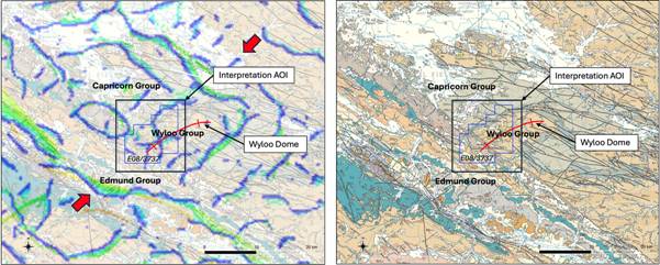
Figure 1 - Regional scale geological setting:
(Left) Gravity worms. (Right) 1:250K Mapped geology.
Magnetic & Radiometric Survey Results
A high-resolution, low-level airborne magnetic and radiometric survey was completed across the entire Gorge Project licence area. The final processing and interpretation work has provided GEO with a substantially more detailed understanding of the Project's geological framework and has further upgraded the previously reported MAG001 magnetic anomaly and associated RAD001 and RAD002 radiometric anomalies.
Interpretation of the magnetic data identified a network of faults and shear structures extending across the licence, including several structures with significant strike length. Longer and more continuous faults may extend deeper into the crust and therefore have greater potential to act as pathways for large-scale fluid flow and mineralisation.
Worming of the detailed magnetic and radiometric datasets has enabled GEO to map the local scale geological and fault framework in significantly greater detail.
The interpretation identifies secondary northeast-southwest fold structures within the broader Wyloo Dome, together with several enclosed magnetic anomalies which may represent previously unrecognised intrusive bodies.
Numerous local faults appear to cut across these folds and potential intrusive features. The areas where faults, folds and possible intrusive contacts intersect are considered particularly prospective because they may create favourable pathways and depositional sites for mineralising fluids. The magnetic and radiometric responses have also revealed previously unrecognised geological units or "domains". These results indicate that the fold and fault architecture at the Gorge Project may be considerably more complex than historical mapping suggested.
Areas where anomalous magnetic and/or radiometric responses occur within this structural framework have therefore been prioritised for follow-up exploration.
The completed interpretation has materially advanced GEO's understanding of the Gorge Project from a series of individual historic gold occurrences into a broader geological system containing multiple potentially favourable mineralised settings.
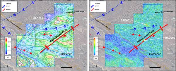
Figure 2 - Simplified interpreted geology and geophysical anomalies:
(Left) RTP magnetic image with worms. (Right) U Ch image with worms.
LIDAR and Aerial Photography Survey
Interpretation of the Gorge Project LiDAR and aerial photography materially improved GEO's ability to identify and map:
· historic shafts and trenches;
· quartz veining;
· geological outcrops;
· bedding and cleavage orientations;
· local fault and fold structures;
· tracks and potential access routes;
· drainage patterns; and
· changes in surface cover and weathering.
In total, 24 shafts and 12 trenches were identified from the LIDAR data. The number of identified workings is materially greater than previously recognised and demonstrates that historic prospecting and mining activity was more extensive across the Project than indicated by the available records.
Several shafts appear to have been developed directly along quartz veins visible in the aerial imagery. This is considered significant because it suggests historic miners were targeting specific bedrock structures and quartz-vein systems rather than solely recovering shallow or transported surface gold.
Ground truthing, mapping and sampling of historic mullock heaps and trenches identified will be completed during the forward work programme.
Extensive quartz veining has been interpreted across the Project. These show areas of significant vein density with veins mapped in both concordant and discordant orientations. Quartz veining is considered a key vector to gold mineralisation and local scale target generation and drill targeting.
Numerous geological outcrops were identified and have allowed for bedding and cleavage form lines to be interpreted across the Project. These are considered key data inputs into deriving the structural interpretation with numerous faults and fold structures interpreted. Areas of structural complexity are considered more prospective for orogenic-style gold mineralisation.
Analysis of these data has significantly advanced GEO's understanding of draining patterns and regolith distribution at the Project. A significant watershed feature and associated change in regolith is evident across the central part of the Project. This observation impacts on the interpretation of geochemical and radiometric data and may assist to vectoring to the source of the primary bedrock gold mineralisation.
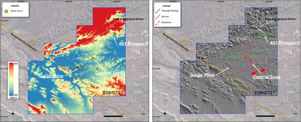
Figure 3 - LIDAR DTM interpretation results:
(Left) Identified historical workings. (Right) Interpreted quartz veins, bedding/ cleavage form lines and watershed.
Litho-Structural Geological Interpretation
Three groups of Proterozoic sedimentary rocks underlie the Gorge Project. The oldest and centrally located unit, the Wyloo Group belonging to the Ashburton Formation, is considered the most prospective for gold and polymetallic mineralisation.
The Wyloo Group is flanked to the northwest and southeast by the younger Capricorn Group, which sits above it. Both groups have been folded along regional northeast-southwest trends, with the Wyloo Group exposed within the interpreted Wyloo Dome. A third geological unit associated with the Bangemall Basin occurs to the south and sits above the older rock groups. This unit was subsequently deformed along northwest-southeast trends, overprinting the earlier deformation within the Wyloo and Capricorn groups.
Mafic dykes were later emplaced across the geological sequence, largely exploiting pre-existing structural trends. This multi-stage geological history has created a more complex fold and fault architecture than was previously recognised and is considered important to the Project's mineralisation potential.
Fault and quartz-vein patterns are key indicators of prospectivity in structurally deformed sedimentary terrains. Mapping and interpretation at the Gorge Project show a strong northwest-southeast orientation of cleavage, faults and quartz veins within the Wyloo Group.
A second northeast-southwest fault system has also had a significant influence on the architecture of the Wyloo Dome. Evidence for this includes the emplacement of a mafic dyke along the interpreted axis of an early fold, together with interpreted sinistral fault offsets and similar structural trends elsewhere in the district.
Regional gravity, airborne electromagnetic and magnetic data also suggest the presence of a deep-seated, crustal-scale northeast-southwest basement structure spatially associated with the Wyloo Dome. Structures of this scale can provide pathways for mineralising fluids from depth and add to the prospectivity of the Project.
Both dominant fault orientations are considered prospective in their own right. However, areas where the two structural directions intersect are considered higher-priority targets because they may provide enhanced pathways and favourable sites for mineralisation.
The detailed magnetic and radiometric surveys have also identified previously unrecognised geological domains, further indicating that the fold and fault pattern across the Gorge Project is more complex than historical mapping suggested. Areas where anomalous magnetic and/or radiometric responses occur within this structural framework have been prioritised for follow-up exploration.
Taken together, the multiple phases of folding and faulting, deep-seated structural setting, mafic dykes, quartz veining and newly identified geological domains provide GEO with a significantly strengthened litho-structural model for targeting gold mineralisation at the Gorge Project.
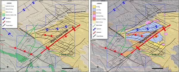
Figure 4 - Lithology and structural interpretation:
(Left) Solid geology. (Right) Wyloo magnetic domains.
Key Prospects and Target Generation
The integrated interpretation has identified nine further exploration targets in addition to the existing rank-one targets at Gorge Mine Prospect, 401 Prospect and MAG001. This increases the current Gorge Project target inventory to 12 areas. Target generation was achieved via an integrated approach that considered: geophysical response, geochemical response, structural complexity, quartz veining and historic workings.
Gorge Mine
Gorge Mine prospect remains a rank-one priority target based on historic workings, shafts and previously reported elevated rock-chip and stream-sediment geochemistry. The target has been further upgraded following the identification of additional vertical shafts and a greater density of quartz veining from the LiDAR and aerial photography.
Gorge Mine prospect lies along a significant west-northwest to east-southeast structural zone which is intersected by northeast-southwest structures, creating an area of increased structural complexity. The combination of historic gold workings, existing geochemistry, extensive quartz veining and intersecting structures is considered consistent with the potential presence of an orogenic gold system.
The final interpretation indicates that the historic activity at Gorge Mine may form part of a wider structurally controlled mineralised zone rather than representing an isolated occurrence.
401 Prospect
The 401 Prospect remains a rank-one priority target based on historic workings, previous drilling and elevated rock-chip, soil and stream-sediment geochemistry. The final interpretation has further upgraded the target by identifying its position along a significant northwest-southeast magnetic gradient.
Several nearby magnetic closures and mapped quartz eye porphyry outcrop may also indicate the presence of a proximal intrusive bodies. The combination of historic gold mineralisation, existing geochemistry, structural complexity and the possible intrusive association means the 401 Prospect target is considered prospective for both orogenic and intrusion-related gold mineralisation.
MAG001 Target
MAG001 remains a rank-one priority target located in the northwest of the licence in an area which has not previously been explored. The target comprises a strike-limited positive magnetic anomaly with an amplitude of approximately 400 nanoteslas.
Three-dimensional inversion modelling indicates that the top of the magnetic body may occur approximately 300 metres beneath the surface, with significant interpreted vertical extent. MAG001 is located close to the RAD001 radiometric anomaly. Interpretation of the local watershed and drainage patterns indicates that the radiometric response is likely to be located close to its original source rather than having been transported into the area by surface drainage, further upgrading the target.
The target is also associated with a LiDAR-defined topographic feature, substantial quartz veining and iron-oxide staining visible in the aerial imagery. MAG001 occurs along a significant northeast-southwest structure and close to several interpreted structural intersections and areas of geological complexity including the Capricorn Group unconformity and drainage watershed feature.
The combined magnetic, radiometric, structural and surface signature is considered consistent with the potential presence of an intrusion-related gold system and/or an iron oxide copper-gold-style mineral system.
The combination of these features, together with the absence of historic exploration, makes MAG001 one of the Company's highest-priority targets for future investigation.
Nine Further Targets
The nine further targets comprise areas where combinations of geophysical responses, structural intersections, quartz veining, historic workings and existing geochemical anomalies occur together.
While currently ranked below MAG001, Gorge Mine Prospect and the 401 Prospect targets, based on the available information, they materially expand the number of potential mineralised centres identified across the licence.
The larger target inventory gives GEO greater flexibility to test and advance multiple areas and reduces the Company's reliance on the success of any single target. The rankings will continue to evolve as field observations, laboratory assays and further geochemical results are incorporated into the geological model.
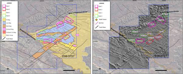
Figure 5 - Ranked targets on:
(Left) Solid geological interpretation. (Right) LIDAR DTM with interpreted workings and quartz veins.
|
Name
|
Rank
|
Comment
|
|
Gorge Mine
|
1
|
Historic workings, shafts, rock chips, historic production, WNW structure, numerous quartz veins
|
|
401 Prospect
|
1
|
Historic workings, drill intercepts, rock chips, NW fault zone, margin mag high possibly intrusive
|
|
MAG001
|
1
|
Intrusive, 400nT high magnetic intensity body, subjacent high U response, structural complexity, moderate quartz veins, just beneath Capricorn unconformity
|
|
RAD002
|
2
|
U anomaly, mostly in drainage, on NE-SW Shear Zone and dyke, structural complexity, numerous quartz veins, historic workings
|
|
Central Dome
|
2
|
High magnetic signature in semi-circular closure, moderate quartz veins, U enrichment to NW side of central structure
|
|
Central Zone
|
3
|
Numerous quartz veins, structural complexity, large drainage area, limited outcrop
|
|
Liverpool
|
3
|
Structural intersection, Au stream 82 ppb, moderate quartz veins
|
|
Tadpole
|
3
|
Antiform, low order structural intersection, moderate quartz veins, historic workings
|
|
Gossan Valley
|
4
|
Cu gossan, moderate quartz veins, structural complexity, disrupted magnetic gradients
|
|
Gorge West
|
4
|
Moderate quartz veins, on strike from Gorge Mine
|
|
N Star
|
4
|
Intrusive high magnetic signature, quartz veins
|
|
Quartz Valley
|
4
|
Significant quartz veining, significant NE-SW structure, close to Capricorn Unconformity
|
Figure 6 - Ranked Targets Table
Forward Programme
The targets identified will be further tested by the upcoming field programme that will consist of an extensive soil and rock chip geochemistry survey, geological mapping and controlled sampling of mullock heaps from historic shafts and trenches. This work is expected to further assist in ranking and refinement of the targets and planning for the proposed maiden drilling programme. Drilling activities remain subject to completion of the required heritage and government permitting processes.
Tom Harris, GEO's Exploration Manager, commented:
"The interpretation of airborne geophysical datasets has confirmed and generated new high priority targets that warrant further investigation and drill testing. I am excited that the LIDAR data clearly shows that there are far more historical vertical shafts than anticipated. I look forward to receiving assay results from the trial soil geochemistry and commencement of the next phase of field work."
Dr Finbarr Murphy, GEO's Technical Consultant, commented:
"The regional and local scale geological setting observed at the Gorge Project is consistent with numerous globally significant mineral systems. The quality of the airborne geophysical surveys collected has resulted in a structural and lithological geological interpretation that has a high degree of confidence. I look forward to seeing the high priority targets generated tested."
Omar Ahmad, Chief Executive Officer, commented:
"We are excited by these results and increasingly confident in the potential of the Gorge Project, with nine further targets now generated alongside the continued upgrading of our three rank-one targets.
The interpretation has identified the regionally significant Wyloo Dome, a geological setting associated with major Australian gold deposits including Telfer and Fosterville, which is highly encouraging for the Company.
Progress at the Gorge Project continues to reinforce its growing importance to GEO. I would like to thank Dr Finbarr Murphy for his excellent work alongside Callum Baxter and Tom Harris, whose combined expertise gives us growing confidence as we advance the next phase of exploration."
Gorge Project Overview
The Gorge Project comprises Exploration Licence E08/3737, located approximately 110km west of Paraburdoo in Western Australia. The licence covers 81km² within the Capricorn Orogen and is held through GEO's 100%-owned subsidiary, Gorge Gold Pty Ltd.
Historical exploration, prospecting and mining activity has identified gold occurrences over approximately 5km of strike, including rock-chip results of up to 134g/t Au, soil results of up to 233g/t Au, historical drilling including 1m at 35g/t Au and the recovery of near-surface gold nuggets ranging from less than 2g to more than 100g.
GEO commenced a systematic modern exploration programme at the Gorge Project during 2026. High-resolution LiDAR, aerial photography, magnetic and radiometric surveys have improved the definition of the known gold trend and identified new priority targets, including the MAG001 magnetic anomaly and the RAD001 and RAD002 radiometric anomalies. MAG001 has an interpreted depth to top of approximately 300m, significant vertical extent and is coincident with a LiDAR-defined topographic feature and iron-oxide staining observed at surface.
Field reconnaissance in May/June 2026 has confirmed priority areas at the Gorge Mine, 401 and Central Zone prospects. Work completed includes geological and structural mapping, confirmation of historic workings and drill locations, collection of 35 rock-chip samples and 246 orientation soil samples, and identification of visible gold in quartz vein material, significant quartz veining and alteration, and copper-rich gossan at the Central Zone. GEO is integrating the geophysical, geological and geochemical datasets to refine targets for follow-up sampling and the proposed maiden drilling programme.
These results along with the proximity of the nugget recoveries suggests the potential presence of a primary bedrock gold source within the licence area.
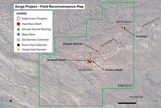
Figure 7 - Field Reconnaissance Map.
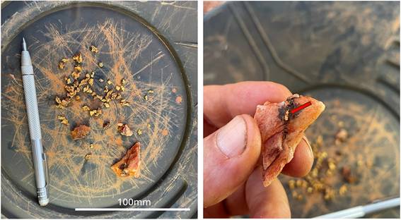
Figure 8 - Gold-bearing material recovered by metal detecting around the Central Zone target area during a single day of prospecting on 28 May 2026. Coarse free gold is observed in association with quartz veining and sulphide alteration along fractures. The angular nature of the quartz vein sample suggests limited transport from the bedrock source.
|