|
Highlights
· Systematic exploration campaign at Gorge Project scheduled to commence this month.
· Geological reconnaissance will commence on or around mid-May 2026.
· Airborne geophysical surveys are expected to have commenced by the fourth week of May 2026.
· Information gathered will allow for an integrated dataset to support a modern litho-structural interpretation and rank priority targets for follow-up geochemistry and maiden drilling campaign.
· Desktop review of previous exploration including geochemistry and drilling is ongoing.
GEO Exploration Limited (AIM: GEO) is pleased to announce the commencement of a structured, data-driven exploration programme at its 100% owned Gorge Project in Western Australia, representing a key milestone in advancing the Company's gold portfolio.
The programme marks GEO's transition from historical data compilation into active field execution, integrating modern geophysical datasets with targeted geological validation to refine priority target areas and advancing the project towards a maiden drilling campaign.
This work is designed to unlock the potential of what the Company believes to be a potentially underexplored gold system, with mineralisation already identified over approximately 5km of strike.
Gorge Exploration Activities Programme May 2026
The Gorge Project will be advanced through a structured and integrated exploration programme, incorporating multiple workstreams to support ongoing target generation and progression towards drilling.
Field Validation & Geological Mapping
Field-based geological activities will commence on or around mid-May 2026, including:
· Validation of historical geochemical results to confirm and refine known anomalous areas
· Confirmation of historic workings and previously recorded drill locations
· Detailed geological and structural mapping to better understand controls on mineralisation
Supporting logistical work will then follow during Q2 2026, including:
· Access preparation to enable efficient field operations
· Completion of required heritage surveys
This work will support the progression of follow-up geochemical programmes and planned drilling activities.
Airborne Geophysical Surveys
Contracts to acquire airborne geophysical datasets have been executed and awarded to Aerometrex Ltd and MAGSPEC Airborne Surveys Pty Ltd, respectively. Survey activities are expected to have commenced by the fourth week of May 2026, subject to operational factors including fuel availability, and will include:
· Magnetic surveys to delineate subsurface structures and lithological boundaries
· Radiometric surveys to assist in mapping alteration patterns and regolith
· LiDAR acquisition to provide high-resolution topographic data and support structural interpretation
· Aerial photography to enhance surface mapping and identification of historical workings
These datasets will support:
· Detailed mapping of historical workings and surface features
· Development of a litho-structural interpretation across the licence area
· Improved understanding of structural controls on mineralisation
· Identification and refinement of priority target areas
· Ongoing target generation and ranking activities
The information derived from the proposed geochemical and geophysical surveys will allow the company to begin planning and target generating for its maiden drilling programme for Gorge Project. The maiden drill programme will consist of Reverse Circulation (RC) drill holes to test beneath known areas of surface gold mineralisation occurrences in addition to targets generated from the above surveys. Drilling activities will commence after the completion of heritage and government permitting.
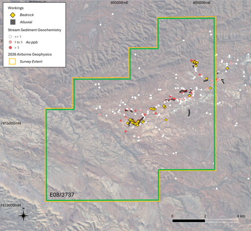
Figure 1 - Aerial Photo of Exploration Licence E08/3737 and Planned 2026 Airborne Survey Extent
Gorge Project Overview
The Gorge Project (Exploration Licence E08/3737), located approximately 110km west of Paraburdoo in Western Australia, covers an area of 81 square kilometres within the Proterozoic aged Capricorn Orogen. GEO recently acquired the licence, through its 100% owned subsidiary Gorge Gold Pty Ltd. The Gorge Project is considered highly prospective for large scale gold systems of Orogenic-type or Carlin-type.
Limited historical exploration at Gorge has identified widespread gold mineralisation across the licence area. Gold occurrences have been recorded over approximately 5km of strike, supported by drainage, soil and rock chip sampling, historic workings, and alluvial and eluvial gold mining.
Historical results include:
· Rock chip samples returning gold values up to 134g/t Au
· Soil samples returning gold values up to 233g/t Au
· Drainage sampling returning elevated gold values
· Recovery of multiple gold nuggets from near surface, ranging from <2g to in excess of 100g
These results along with the proximity of the nugget recoveries suggests the potential presence of a primary bedrock gold source within the licence area.
Omar Ahmad, Chief Executive Officer, commented:
"I would like to thank Callum Baxter for identifying the Gorge Project opportunity and ongoing support to GEO as we progress Gorge Project. This programme marks GEO's transition from historical datasets into active exploration across The Gorge Project licence.
At Gorge, the scale and continuity of historical gold mineralisation provide a compelling foundation for systematic target generation of what could be a potential discovery of an underexplored gold system.
By integrating modern geophysics with targeted field validation, we are focused on rapidly advancing high-priority targets towards drilling.
We look forward to updating shareholders as the field programme progresses."
|