
Technical Overview of the Clarkdon Gold Property
Summary by AI BETAClose X

23 October 2026
Focus Xplore PLC
(‘Focus Xplore’ or the ‘Group’)
Technical Overview of the Clarkdon Gold Property
Focus Xplore PLC (AIM: FOX) ("Focus Xplore" or the "Company") provides a technical review and details of the Phase 1 exploration programme underway for the Clarkdon Gold Property ("Clarkdon" or the "Property"), situated in northwestern Ontario, Canada, following its recent acquisition by the Company.
Key Highlights
- Phase 1 Fieldwork underway on the property; including soil geochemical sampling and geological prospecting over two main target areas.
- Strategic Location: 18km2 (1,800 hectare) claim package situated 50 km northwest of Ignace, Ontario, with established logistical access via a former railway line and forestry roads.
- Prospective Geological Setting: Located within the c. 2.7 billion-year-old Sturgeon Lake greenstone belt of the Superior craton, with the crustal-scale South Sturgeon Fault Zone crossing the south of the Property – a deep-rooted structure comparable in setting to the prolific Porcupine-Destor and Cadillac-Larder Lake gold corridors of the Abitibi.
- Untested Gold Targets: Two priority target areas, the South Sturgeon Fault Zone and the Central Structural & Magnetic Corridor, defined by magnetic and conductive trends, mapped alteration and sulphide occurrences, with no systematic gold exploration carried out to date.
Geological Summary
The 18 km² Clarkdon property is located in northwestern Ontario, on the Sturgeon Lake greenstone belt, part of the Superior craton, the world's largest Archaean craton. The belt is about 2.7 billion years old and hosts historical zinc-copper volcanogenic massive sulphide (VMS) mines. Recent seismic and magnetotelluric geophysical surveys suggest the belt was thrust into place along a major fault zone, the South Sturgeon Fault Zone, which crosses the south of the property1, and forms the boundary between the Winnipeg River and Western Wabigoon Terrane. Such terrane boundaries, defined by major fault zones in this part of Ontario are commonly associated with gold2.
Locally, the property is underlain mainly by metamorphosed volcanic rocks, with bands of schist and gabbro, bordered to the south by granite and cut by faulting3 (see Figure 1). Historical drilling in 1971 intersected copper-bearing sulphides at the Moss Lake occurrence in the north of the property. Linear magnetic trends in legacy airborne data, linked to mapped alteration and faults4, have never been tested for gold and offer early-stage, grassroots targets for gold mineralisation.
The tenure is in good standing until 15 February 2027 and carries an annual minimum spend commitment of C$34,400 (approximately £19,000).
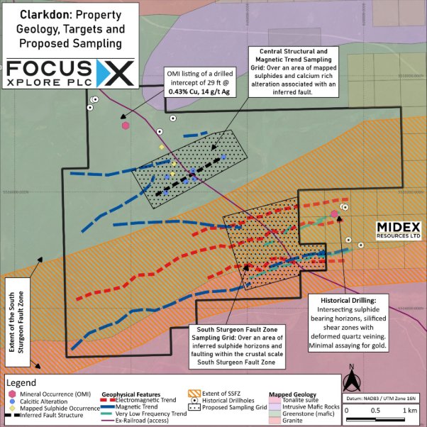
Figure 1: Clarkdon Property Geology, Targets and Proposed Sampling
Previous Exploration on the Clarkdon Property
Clarkdon has minimal historical exploration. A six-hole, 534 ft (162.8 m) diamond drilling programme, using 7/8 in (22 mm) core, was completed in the north of the property in 1971 by Scurry-Rainbow Oil Limited5 6 (detailed below), and is recorded in the Ontario Mineral Inventory as a historical intercept of 29 ft (8.84 m) grading 0.43% Cu and 14 g/t Ag.
Elsewhere, the property has received only geological mapping in the late 1960s4 and airborne geophysical surveys and interpretation3 in 1970; no further work is reported to have been carried out on the property.
Exploration Model for Clarkdon
The exploration model for Clarkdon centres on targeting gold mineralisation associated with the South Sturgeon Fault Zone (SSFZ), which is a major, deep-rooted regional structure that may act as a pathway for gold-bearing fluids1, similar to the highly prolific Porcupine-Destor and Cadillac-Larder Lake fault corridors in the Abitibi Gold District. The SSFZ is interpreted to extend to depths of 20–40 km in the crust, which may have allowed potentially auriferous, deep-seated fluids to be driven upwards during major geological events1. Such fault systems can host significant gold mineralisation where they intersect or interact with smaller fault networks, competent intrusive rocks, volcanic units, and banded iron formations 7 8, and therefore represent attractive targets for gold exploration.
The property has two main target areas:
- South Sturgeon Fault Zone
- Central Structural & Magnetic Corridor
These areas are shown, alongside the general property geology, on Figure 1.
South Sturgeon Fault Zone Potential
In the southern sector of the claim package, airborne electromagnetic (AEM) and magnetic geophysical surveys have delineated prominent conductive and magnetic horizons10.
Historical drilling11 within the SSFZ, approximately 600 m east of the property, intersected disseminated to massive pyrrhotite-pyrite in sheared felsic to intermediate volcanic rocks and schists adjacent to a granitic contact. Sulphide-bearing horizons are displaced by northwest-striking cross-faults, and the host rocks include silicified shear zones with deformed quartz veining – very limited assaying for gold took place in these units, and thus the majority of the sulphide units were untested. On Clarkdon, legacy Very Low Frequency (VLF) trends suggest the presence of faulting and structure associated with these potentially sulphide units.
This combination of structural intersections and contrasting lithologies is geologically favourable for gold mineralisation7, especially in proximity to a major, crustal-scale fault system.
Central Structural & Magnetic Trend
The central part of the property is characterised by linear magnetic trends in legacy airborne geophysics that have not been tested for gold. These lineaments occur close to mapped alteration and secondary structural zones, and one linear feature weakens in the property centre. Such weakening may reflect magnetite destruction by hydrothermal alteration, a recognised vector towards structurally controlled gold mineralisation7, although other causes cannot be excluded. Historical mapping records carbonate-bearing alteration and disseminated to massive sulphides in this area4. Calc-silicate and carbonate assemblages are commonly associated with hydrothermal fluid migration in orogenic gold systems12, making this area a target for gold exploration.
Regionally, similar structural trends host auriferous quartz veins and shear-hosted mineralisation13, including up to 6.17 g/t Au and 1,000 ppm Co; however, equivalent targets at Clarkdon have not yet been tested. Results from neighbouring areas are not necessarily indicative of mineralisation on the Property.
Moss Lake Base Metal Occurrence
In the north of the property, historical diamond drilling by Scurry-Rainbow Oil Limited in 1971 5 6 comprised six shallow holes totalling 534 ft (162.8 m) of 7/8 in (22 mm) core. The holes intersected amphibolitic greenstone, meta-gabbro and gabbro with minor pyrite, trace chalcopyrite, local pyrrhotite, quartz veining and calcite stringers. The Moss Lake occurrence was subsequently recorded in the Ontario Mineral Inventory (OMI14), which lists a historical intercept of 29 ft (8.84 m) grading 0.43% Cu and 0.41 oz/t Ag (about 14 g/t) within amphibolitic greenstone. Moss Lake is interpreted as primary, pre-metamorphic mineralisation that is not considered related to any later gold mineralisation on the property, and it is not currently a key target area.
Regional Context & Infrastructure
The property lies within an active exploration district. Claims held by Midex Resources Ltd border it immediately to the east (Figure 1), and Glencore Canada holds significant mineral tenure about 7 km along strike to the east. Forestry access roads and a former railway line, now converted to a track, cross the tenure, giving good surface access from Highway 599, which runs north from the Trans-Canada Highway (Highway 17) at Ignace.
Phase 1 Exploration Programme
Focus Xplore has allocated £23,000 from the recent £0.5m placing to fund a Phase 1 field exploration programme at Clarkdon, in October 2026. The costs of this programme will allow the Company to meet the minimum expenditure requirement.
The planned exploration programme consists systematic geochemical soil sampling and geological prospecting over two main areas;
- Central Structural & Magnetic Trend – A sample grid over an area of mapped sulphides and calcium-rich alteration, on an inferred fault structure and area of weakened magnetic response. This area is inferred to be prospective for mineralisation associated with secondary fault splays within the South Sturgeon Fault Zone.
- South Sturgeon Fault Zone This sampling is designed to test the extent of the SSFZ on Clarkdon for gold mineralisation; the grid is located over the continuation of geophysical features, for which historical exploration drilled sulphide-rich horizons, but did not fully analyse for gold. The aim of this sampling is to determine which, if any, of the conductive/magnetic trends in this area of the SSFZ may host gold mineralisation.
REFERENCES
|
1 |
Ma, C., Naghizadeh, M., Adetunji, A., Lodge, R.W.D., Snyder, D. and Sherlock, R. (2021) 'Imaging Neoarchean crustal structures: An integrated geologic-seismic-magnetotelluric study in the western Wabigoon and Winnipeg River terranes, Superior craton', Precambrian Research, 364, article 106339. doi:10.1016/j.precamres.2021.106339. |
|
2 |
Groves, D.I., Goldfarb, R.J., Gebre-Mariam, M., Hagemann, S.G. and Robert, F. (1998) 'Orogenic gold deposits: a proposed classification in the context of their crustal distribution and relationship to other gold deposit types', Ore Geology Reviews, 13(1-5), pp. 7-27. doi:10.1016/S0169-1368(97)00012-7. |
|
3 |
Ontario Geological Survey (n.d.) Press Lake area, District of Kenora (Patricia portion). Exploration Data Map, Geological Data Inventory Folio 455 (Map 3 of 3). Scale 1:31,680. Ontario: Ministry of Northern Development and Mines. |
|
4 |
Trowell, N.F. (1970) Watcomb area, District of Kenora. Map 2209, scale 1:31,680. Toronto: Ontario Department of Mines and Northern Affairs, Geological Branch. |
|
5 |
Scurry-Rainbow Oil Limited (1971a) Diamond drilling, Press Lake area, report no. 10 (holes 1-4). Calgary: Scurry-Rainbow Oil Limited. Unpublished assessment report, Ontario Geological Survey, AFRI no. 52G14SW0002. |
|
6 |
Scurry-Rainbow Oil Limited (1971b) Diamond drilling, Press Lake area, report no. 11 (holes 5-6). Calgary: Scurry-Rainbow Oil Limited. Unpublished assessment report, Ontario Geological Survey, AFRI no. 52G14SW0003. |
|
7 |
Groves, D.I., Goldfarb, R.J., Gebre-Mariam, M., Hagemann, S.G. and Robert, F. (1998) 'Orogenic gold deposits: a proposed classification in the context of their crustal distribution and relationship to other gold deposit types', Ore Geology Reviews, 13(1-5), pp. 7-27. doi:10.1016/S0169-1368(97)00012-7. |
|
8 |
Frieman, B.M. and Kuiper, Y.D. (2019) 'Evolution of gold-bearing splays of crustal-scale fault zones of the south-central Archean Abitibi subprovince: constraints from the Kirana deformation zone, Kirkland Lake, Ontario, Canada', Journal of Structural Geology, 127, article 103867. doi:10.1016/j.jsg.2019.103867. |
|
9 |
Questor Surveys Limited (1970) Airborne magnetic and electromagnetic survey reports: |
|
10 |
Clarkdon and Watcomb areas, Ontario [Assessment Report]. Prepared for New Calumet Mines Limited. Ontario Department of Mines Assessment File 2.27. |
|
11 |
Pioneer Consultants Limited (1971) Valora property, Sturgeon Lake area, Ontario: geophysical surveys and diamond drilling, October 1970 to January 1971. Unpublished assessment report prepared for New Calumet Mines Limited and Zenmac Metal Mines Limited. Haileybury, Ontario: Pioneer Consultants Limited. Ontario Geological Survey, Assessment File Research Imaging (AFRI) no. 52G14SE0068. |
|
12 |
Dubé, B. and Gosselin, P. (2007) 'Greenstone-hosted quartz-carbonate vein deposits', in Goodfellow, W.D. (ed.) Mineral deposits of Canada. St. John's: Geological Association of Canada, Mineral Deposits Division, Special Publication No. 5, pp. 49-73. |
|
13 |
https://www.geologyontario.mines.gov.on.ca/mineral-inventory/MDI52G14SE00005 |
|
14 |
https://www.geologyontario.mines.gov.on.ca/mineral-inventory/MDI52G14SE00032 |
GLOSSARY
|
Term |
Definition |
|
Abitibi |
The Abitibi greenstone belt, straddling the Ontario–Quebec border; one of the world's most productive gold regions, hosting the Timmins, Kirkland Lake and Val-d'Or gold camps. |
|
AEM |
Airborne electromagnetic: an electromagnetic survey flown by aircraft or helicopter to map electrically conductive zones in the ground, such as sulphide- or graphite-bearing horizons and some fault zones. |
|
Alteration |
Changes to a rock's mineralogy, chemistry or texture caused by hot fluids passing through it. Alteration often forms a halo around mineral deposits and is used as a guide to mineralisation. |
|
Amphibolitic |
Describes a rock made up mainly of amphibole minerals (e.g. hornblende) and plagioclase feldspar, typically formed by metamorphism of mafic volcanic or intrusive rocks such as basalt or gabbro. |
|
Archaean |
The geological eon between approximately 4.0 and 2.5 billion years ago. Archaean greenstone belts host many of the world's major gold deposits. |
|
Assay |
Laboratory analysis of a rock, soil or drill sample to determine its metal content. |
|
Assemblage |
A group of minerals that formed together under the same conditions. |
|
Assessment report |
A report of exploration work filed with the Ontario government by a claim holder, which credits the work towards the expenditure required to keep claims in good standing. Filed reports become public records. |
|
Auriferous |
Gold-bearing. |
|
Banded iron formation (BIF) |
A sedimentary rock of alternating thin layers of iron-rich minerals (such as magnetite) and silica (chert). Its iron-rich layers can react with gold-bearing fluids, making it a favourable host for gold. |
|
Base metal |
Common non-precious metals such as copper, zinc, lead and nickel. |
|
Cadillac-Larder Lake Fault Zone |
A crustal-scale fault zone in the Abitibi greenstone belt, running from Ontario into Quebec, associated with the Kirkland Lake, Malartic and Val-d'Or gold camps. |
|
Calc-silicate |
Rocks or mineral assemblages made up of calcium-bearing silicate minerals (e.g. epidote, diopside, actinolite), typically formed where calcium-rich rocks or fluids are altered or metamorphosed. |
|
Calcite stringer |
A thin, thread-like vein of calcite (calcium carbonate) cutting through rock. |
|
Carbonate (calcitic) alteration |
Alteration in which carbonate minerals (e.g. calcite, dolomite, ankerite) are added to a rock by circulating fluids; also described as calcium-rich alteration. It commonly forms a halo around orogenic gold deposits. |
|
Chalcopyrite |
A copper-iron sulphide mineral (CuFeS₂); the most common copper ore mineral. |
|
Competent (rock) |
A strong, rigid rock that tends to fracture rather than flow when deformed. Fractures in competent rocks can channel and trap mineralising fluids. |
|
Conductive / conductor |
A zone that conducts electricity more readily than the surrounding rock, detected by electromagnetic surveys. Conductors may be caused by sulphide minerals, graphite, clays or water-bearing faults, so require follow-up to determine their source. |
|
Contact |
The boundary between two different rock types. |
|
Core |
A cylindrical sample of solid rock recovered by diamond drilling. |
|
Corridor |
An elongate zone containing related faults, shear zones or other geological structures. |
|
Craton |
An old, thick and stable part of the continental crust that has remained largely undeformed for billions of years. |
|
Cross-fault |
A fault that cuts across the main structural trend or rock units, often displacing them. |
|
Crustal-scale fault |
A major fault that extends deep into the Earth's crust (tens of kilometres) and can be traced over long distances at surface. Such faults can act as pathways for deep-sourced, gold-bearing fluids. |
|
Diamond drilling |
A drilling method that uses a rotating, diamond-set bit to cut a continuous cylinder of rock (core), allowing detailed logging and sampling. |
|
Disseminated |
Mineral grains (e.g. sulphides) scattered through a rock, as opposed to concentrated in veins or massive layers. |
|
Electromagnetic (EM) survey |
A geophysical method that measures how the ground responds to electromagnetic fields in order to locate electrically conductive bodies. See AEM and VLF. |
|
Fault / fault zone |
A fracture in rock along which movement has occurred. A fault zone is a band of related faults and broken or deformed rock. |
|
Fault splay / secondary structure |
A smaller fault or fracture that branches off, or is linked to, a major fault. Gold deposits along crustal-scale fault systems are commonly hosted in these secondary structures rather than in the main fault itself. |
|
Felsic |
Describes igneous rocks rich in silica and light-coloured minerals (quartz and feldspar), such as rhyolite and granite. |
|
Gabbro / meta-gabbro |
A dark, coarse-grained intrusive igneous rock of mafic composition; the intrusive equivalent of basalt. Meta-gabbro is gabbro that has been metamorphosed. |
|
Geochemical soil sampling |
Systematic collection of soil samples, usually on a grid, which are analysed for gold and other elements to identify anomalous concentrations that may reflect mineralisation in the underlying bedrock. |
|
Geophysical survey |
Measurement of physical properties of the ground (e.g. magnetism, electrical conductivity, density) to map geology and identify targets beneath soil or rock cover. |
|
Granite / granitic |
A light-coloured, coarse-grained intrusive igneous rock composed mainly of quartz and feldspar. |
|
Greenstone |
A metamorphosed mafic volcanic rock (typically basalt) whose green colour comes from minerals such as chlorite, epidote and actinolite. |
|
Greenstone belt |
An elongate belt of metamorphosed volcanic and sedimentary rocks, usually Archaean in age, enclosed by granitic rocks. Greenstone belts host many of the world's major gold deposits. |
|
Historical |
Describes data, drilling results or estimates generated by previous operators before the Company's involvement. Historical results may not have been verified to current industry standards. |
|
Horizon |
A distinct layer or zone within a rock sequence, e.g. a sulphide-bearing horizon. |
|
Hydrothermal |
Relating to hot, water-rich fluids circulating through the Earth's crust. Hydrothermal fluids transport and deposit most metals, including gold. |
|
Intercept |
A length of drill core over which an assay result is reported (e.g. 8.84 m at 0.43% Cu). Intercepts are measured along the drill hole and may not represent the true width of mineralisation. |
|
Intermediate (rock) |
An igneous rock with a silica content between felsic and mafic, such as andesite. |
|
Intrusive |
Igneous rock that formed from magma that cooled and crystallised below the Earth's surface. |
|
Lineament |
A linear feature in geophysical or topographic data, commonly reflecting an underlying geological structure such as a fault or rock contact. |
|
Lithology |
The physical character of a rock (mineral composition, grain size and texture); commonly used to mean rock type. |
|
Mafic |
Describes rocks rich in magnesium- and iron-bearing (dark-coloured) minerals, such as basalt and gabbro. |
|
Magnetic survey |
A geophysical survey that measures variations in the Earth's magnetic field caused by magnetic minerals (mainly magnetite) in rocks. Used to map rock units, faults and alteration. |
|
Magnetite |
A strongly magnetic iron oxide mineral (Fe₃O₄); the main cause of magnetic anomalies in rocks. |
|
Magnetite destruction |
The breakdown of magnetite by hydrothermal fluids into non-magnetic minerals (e.g. pyrite, hematite or carbonate). It produces a weaker magnetic response and can indicate the passage of mineralising fluids. |
|
Magnetotelluric (MT) |
A deep-penetrating geophysical method that uses natural variations in the Earth's electric and magnetic fields to image the electrical resistivity of the crust to depths of tens of kilometres. |
|
Massive sulphide |
Rock composed predominantly of sulphide minerals (commonly more than 50%). |
|
Metamorphosed / metamorphic |
Rock whose mineralogy and texture have been changed by heat and pressure, typically during burial and mountain-building, without melting. The prefix 'meta-' (e.g. meta-gabbro) denotes a metamorphosed rock. |
|
Mineral occurrence |
A documented location where mineralisation has been observed; it does not imply economic size or grade. |
|
Mineralisation |
A concentration of metals or minerals of potential economic interest within a body of rock. Mineralisation does not imply that an economic deposit exists. |
|
Orogenic gold |
The dominant class of gold deposit in Archaean greenstone belts, formed during mountain-building (orogenic) events when gold-bearing fluids migrate up major fault zones and deposit gold in quartz-carbonate veins and altered rocks, commonly in secondary structures close to crustal-scale faults. |
|
Porcupine-Destor Fault Zone |
A crustal-scale fault zone in the Abitibi greenstone belt associated with the Timmins (Porcupine) gold camp, one of the largest gold-producing districts in Canada. |
|
Pre-metamorphic (primary) mineralisation |
Mineralisation that formed at the same time as, or soon after, its host rocks, before later metamorphism and deformation. |
|
Prospecting |
Field examination of rock outcrops to identify mineralisation, alteration and structure, usually with collection of rock samples for assay. |
|
Pyrite |
Iron sulphide (FeS₂); the most common sulphide mineral, often associated with gold in orogenic deposits. |
|
Pyrrhotite |
A magnetic iron sulphide mineral (Fe₁₋ₓS) that is also electrically conductive, so can produce both magnetic and electromagnetic anomalies. |
|
Quartz vein / veining |
A fracture filled with quartz deposited from hydrothermal fluids. Quartz veins are the principal host of gold in orogenic gold deposits. |
|
Schist |
A medium-grained metamorphic rock with a strong layered fabric (foliation) defined by aligned platy minerals such as mica or chlorite, allowing it to split into thin flakes. |
|
Seismic survey |
A geophysical method that uses reflected sound waves to image subsurface rock layers and structures; deep seismic surveys can image the full thickness of the crust. |
|
Shear zone / sheared |
A zone of intense deformation in which rocks have been flattened and smeared by movement. Shear zones are important hosts of orogenic gold. |
|
Silicified |
Rock into which silica (quartz) has been introduced by hydrothermal fluids, making it harder and more resistant; a common alteration associated with gold. |
|
SSFZ |
South Sturgeon Fault Zone: the crustal-scale fault zone crossing the south of the Property, forming the boundary between the Winnipeg River and Western Wabigoon terranes. |
|
Strike / along strike |
The compass direction of a horizontal line on a planar geological feature such as a fault, vein or rock layer. 'Along strike' means in the same direction as that trend; 'northwest-striking' faults run northwest–southeast. |
|
Structure / structural |
Geological features formed by deformation, such as faults, folds and shear zones. 'Structurally controlled' mineralisation is localised by such features. |
|
Sturgeon Lake greenstone belt |
An Archaean (c. 2.7 billion-year-old) greenstone belt in northwestern Ontario, part of the Superior craton, known for historical zinc-copper VMS mining. |
|
Sulphide |
A mineral composed of a metal combined with sulphur (e.g. pyrite, pyrrhotite, chalcopyrite). Sulphides commonly accompany gold and can be detected by electromagnetic surveys. |
|
Superior craton |
The Archaean core of the Canadian Shield (also called the Superior Province), extending across parts of Manitoba, Ontario, Quebec and the northern United States; the largest Archaean craton in the world. |
|
Tenure |
The legal right to explore for and/or develop minerals over an area, held through claims, leases or licences. |
|
Terrane |
A fault-bounded block of the Earth's crust with a geological history distinct from neighbouring blocks. |
|
Thrust |
Movement along a low-angle fault in which one block of rock is pushed up and over another, typically during crustal compression. |
|
Tonalite |
A coarse-grained intrusive igneous rock composed mainly of plagioclase feldspar and quartz; a common granitic rock in Archaean terranes (shown in Figure 1). |
|
Trend |
A linear pattern or alignment in geological or geophysical data (e.g. a magnetic trend), usually reflecting underlying structure or rock units. |
|
Vector |
A geological, geochemical or geophysical feature that points towards possible mineralisation. |
|
VLF |
Very Low Frequency: an electromagnetic survey method that uses signals from distant radio transmitters (3–30 kHz) to detect near-surface conductive features such as faults, shear zones and sulphide zones. |
|
VMS |
Volcanogenic massive sulphide: a type of deposit formed on or near the ancient seafloor by volcanic-related hydrothermal vents, typically rich in copper, zinc and lead, sometimes with gold and silver. |
|
Western Wabigoon terrane |
A terrane of the western Superior craton dominated by Neoarchaean volcanic (greenstone) belts and granitic intrusions. |
|
Winnipeg River terrane |
An older terrane of the western Superior craton composed largely of granitic and gneissic rocks. |
QUALIFIED PERSON STATEMENT
The technical information contained in this disclosure has been reviewed and approved by Mr Nicholas O'Reilly (MSc, DIC, MIMMM QMR, MAusIMM, FGS), who is a qualified geologist and acts as the Qualified Person under the AIM Rules - Note for Mining and Oil & Gas Companies. Mr O'Reilly is a principal consultant working for Mining Analyst Consulting Ltd which is providing independent technical review to Focus Xplore PLC.
**ENDS**
Enquiries:
|
Dave Russell |
info@focusXplore.com |
Focus Xplore PLC |
Executive Director |
|
Jack Dann |
info@focusXplore.com |
Focus Xplore PLC |
Chief Geological Officer |
|
James Biddle Roland Cornish |
+44 (0) 207 628 3396 |
Beaumont Cornish Limited |
Nominated Adviser |
|
Jason Robertson |
+44 (0) 207 374 2212 |
First Equity Limited |
Corporate Broker |
|
Corporate Website: www.focusXplore.com |
LinkedIn: Focus Xplore PLC |
X: @focusXplore |
|
About Reach Announcements
This is a Reach announcement. Reach is an investor communication service aimed at assisting listed and unlisted (including AIM quoted) companies to distribute media only / non-regulatory news releases into the public domain. Information required to be notified under the AIM Rules for Companies, Market Abuse Regulation or other regulation would be disseminated as an RNS regulatory announcement and not on Reach. This announcement is not authorised for distribution into North America or any other jurisdiction where to do so would constitute a violation of the relevant laws or regulations of that jurisdiction
RNS may use your IP address to confirm compliance with the terms and conditions, to analyse how you engage with the information contained in this communication, and to share such analysis on an anonymised basis with others as part of our commercial services. For further information about how RNS and the London Stock Exchange use the personal data you provide us, please see our Privacy Policy.

Latest directors dealings
- 22 minutes ago Personal Assets Trust
- 24 minutes ago Personal Assets Trust
- 2 hours ago Yu Group
- 2 hours ago Springfield Properties
- 2 hours ago Rosebank Industries Plc