Selta Project – Gold exploration update
Summary by AI BETAClose X
08 January 2026
First Development Resources plc
('First Development", "FDR" or the "Company')
Selta Project - Gold exploration update
First Development Resources plc (AIM: FDR), the UK-based, Australia-focused exploration company with mineral interests in Western Australia and the Northern Territory, is pleased to provide an update on its gold ("Au") focussed exploration at the Selta Project ("Selta" or the "Project"), located in the Aileron Province of Australia's Northern Territory.
HIGHLIGHTS
· Gradient Array Induced Polarisation ("GAIP") geophysical survey scheduled to advance the phased gold exploration strategy at the Selta Project.
· Lander West prioritised as a key gold target, interpreted as a continuation of the Stafford Gold Trend adjacent to known gold and antimony mineralisation on neighbouring ground.
· GAIP survey designed to complement the ongoing high-resolution aeromagnetic ("AMAG") and radiometric geophysical surveys, enhancing understanding of subsurface geology and structural features.
· Integration of geophysical and historical datasets expected to refine and prioritise potential drill targets, informing the next phase of exploration at Selta.
Tristan Pottas, Chief Executive Officer of FDR, commented:
"Today's announcement represents the next step in the Company's phased and disciplined approach to advancing its gold exploration strategy at Selta. The gradient array induced polarisation geophysics survey complements the airborne magnetic survey currently underway and, together, these programmes are designed to enhance our understanding of the subsurface geology across the Lander West gold target.
The integration of these datasets is intended to refine and prioritise target areas, increase confidence in their exploration potential and support informed decision-making as we progress our exploration at Selta. This work represents a key step towards the definition of robust drill targets and underpins our objective of systematically advancing Selta through the exploration pipeline."
SELTA GOLD TARGETS
Following a detailed desktop review, several prospective exploration areas for various metals have been identified at Selta, including two named gold targets of which the Lander West Gold Target is the current priority. The locations of the various targets, together with other exploration areas within the Selta Project, are shown in Figure 1.
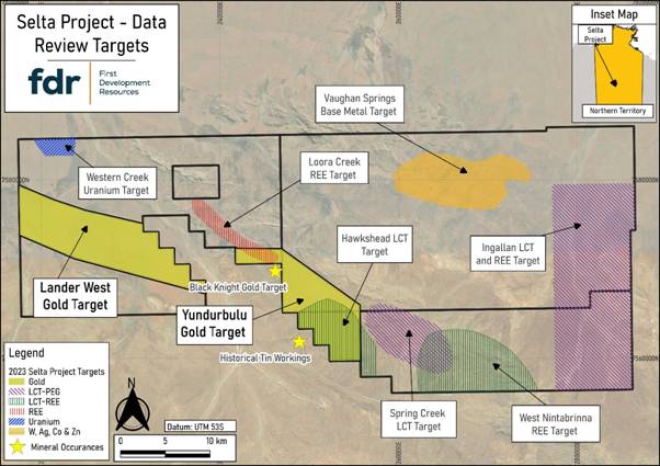
Notes: LCT-PEG = lithium, caesium and tantalum (LCT) pegmatite (PEG)
Figure 1: Selta Project Targets Identified by Data Review
The Company has prioritised the Lander West gold target, which is interpreted as a continuation of the Stafford Gold Trend (Figure 2), where iTech Minerals Pty Ltd (ASX: ITM) has delineated high-grade gold and antimony mineralisation on adjacent ground.1,2 Gold mineralisation within this corridor is interpreted to be shear-hosted, forming along zones of deformation where rocks have been sheared, altered or brecciated.
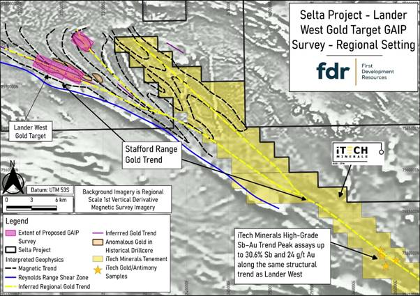
Figure 2: Interpreted extension of Stafford Gold Trend onto the Selta Project
FDR has implemented a staged exploration strategy to progressively refine target areas and define drilling targets. As part of this strategy, the Company is undertaking a Gradient Array Induced Polarisation ("GAIP") geophysical survey at Selta. GAIP is a proven exploration technique that measures subsurface resistivity and chargeability to assist in the identification of mineralised zones and structural features. The technique provides rapid, high-resolution data over large areas, enabling efficient target prioritisation and focused follow-up exploration, including drilling, on the most prospective areas.
The GAIP survey is planned across four survey blocks (Figure 3), each approximately 2 km × 1.5 km in size, located over anomalous gold and pathfinder element concentrations identified from historical drilling and rock-chip sampling. The survey will collect resistivity data to assist in mapping subsurface geology and structures, and chargeability data to identify anomalies potentially related to disseminated sulphide minerals associated with gold alteration systems. The GAIP results, together with follow-up dipole-dipole IP surveys to assess depth extents, will be integrated with magnetic inversion models and existing drilling data to generate robust targets for drilling.
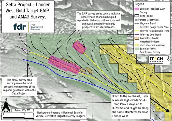
Figure 3: GAIP geophysical survey area in relation to AMAG survey area at the Selta Project
The GAIP survey will follow the Airborne Magnetic ("AMAG") geophysics survey currently being flown at Selta. The announcement relating to the AMAG survey can be accessed via the following link:
Selta Project -exploration update - 07:00:02 18 Dec 2025 - FDR News article | London Stock Exchange
The integration of GAIP and AMAG data at Lander West is expected to maximise exploration effectiveness, with GAIP providing detailed ground-based information on mineralisation and AMAG mapping broader geological structures and lithological variations. Radiometric data, which is being collected concurrently to the AMAG, will help identify potassic alteration zones in areas with no transported cover, as well as uranium and thorium anomalism potentially related to rare-earth element and lithium-caesium-tantalum pegmatite targets. Together, these datasets will assist the Company in refining exploration models, prioritising drill targets and increasing confidence in the identification of prospective mineralised zones.
SURVEY METHODOLOGY AND PARAMETERS
FDR has appointed Zonge Engineering and Research Organisation (Aust) Pty Ltd ("Zonge") to conduct the GAIP survey at Selta. Zonge is an established provider of geophysical survey services with over 40 years' experience operating in Australia and internationally. The company has a proven track record of delivering high-quality geophysical data in a safe, efficient and cost-effective manner, including in technically challenging environments.
GAIP surveys are widely used in mineral exploration to measure subsurface resistivity and chargeability, assisting in the identification of geological features and lithologies associated with mineralisation, particularly disseminated sulphide systems. The method utilises fixed current electrodes and multiple mobile potential electrodes, enabling rapid data acquisition across large areas and supporting the delineation of broad mineralised zones, mapping of structural features and prioritisation of targets for follow-up exploration, including more detailed surveys or drilling.
The GAIP survey involves the injection of an electrical current into the ground via two widely spaced current electrodes, with the resulting voltage gradients measured at multiple locations between these electrodes. From these measurements, key geophysical parameters are derived, including:
· Resistivity, which reflects how strongly rocks resist the flow of electricity, helping map subsurface rock types and alteration zones to identify prospective areas for gold mineralisation. and
· Chargeability (induced polarisation response), which reflects the capacity of subsurface materials to temporarily store electrical charge after the applied current is switched off, helping detect sulphide minerals often associated with gold mineralisation.
These parameters are commonly used to assist in identifying geological features and lithologies associated with mineralisation, particularly disseminated sulphide systems.
Under the gradient array configuration, the current electrodes remain fixed for extended sections of the survey, while multiple pairs of potential electrodes are deployed along survey lines at regular intervals. This configuration enables rapid data collection and high data density across the survey area.
The survey is scheduled to commence in mid-January 2026 and is expected to take approximately four weeks to complete. Following data acquisition, the results will be processed and interpreted, with outcomes used to inform the next phase of exploration at Selta.
REFERENCE
1. iTech Minerals Ltd (ASX: ITM) announcement dated 19 August 2025
( https://announcements.asx.com.au/asxpdf/20250819/pdf/06n0xk4zmh438y.pdf )
2. iTech Minerals Ltd (ASX: ITM) announcement dated 26 November 2025 (https://announcements.asx.com.au/asxpdf/20251126/pdf/06shrvt8qpbc0t.pdf)
GLOSSARY
|
Term |
Definition |
|
Aeromagnetic (AMAG) survey |
An airborne geophysical survey that measures variations in the Earth's magnetic field to map geology and structures. |
|
Dipole - dipole IP survey |
A geophysical method that measures subsurface electrical chargeability and resistivity using pairs of current and potential electrodes. It is used to map the depth and extent of mineralised zones, supporting target definition for exploration and drilling. |
|
Disseminated sulphides |
Fine-grained sulphide minerals (such as pyrite or arsenopyrite) spread throughout the host rock. Their presence can indicate gold or other metal mineralisation and helps guide exploration and drilling targets. |
|
Gold alteration system |
Zones of rock that have been chemically altered by hydrothermal fluids, often associated with gold mineralisation. Identifying these systems helps geologists locate and prioritise prospective gold targets for exploration. |
|
Gold-mineralised trend |
A corridor where multiple gold occurrences align along a structural or geological control. |
|
Gradient Array Induced Polarisation (GAIP) survey |
A geophysical survey method that maps subsurface geology and mineralisation by measuring electrical properties of the ground. GAIP helps identify and prioritise prospective gold targets for follow-up exploration and drilling. |
|
Pathfinder elements |
Elements such as arsenic, antimony, copper, and bismuth that often occur alongside gold mineralisation. Their presence helps geologists identify areas with potential gold deposits and prioritise targets for exploration and drilling. |
|
Potassic alteration |
Rock altered by hydrothermal fluids to form potassium-rich minerals, often associated with gold or copper mineralisation. |
|
Shear zone |
A zone of intense deformation where rocks have been sheared and fractured, often hosting gold. |
|
Structural feature |
A geological break or deformation in rocks such as faults, shear zones, or folds. |
For further information visit www.firstdevelopmentresources.com or contact the following:
|
First Development Resources plc Tristan Pottas (CEO) |
Tel: +44 (0) 20 3778 1397 |
ABOUT REACH ANNOUNCEMENTS
This is a Reach announcement. Reach is an investor communication service aimed at assisting listed and unlisted (including AIM quoted) companies to distribute media only / non-regulatory news releases into the public domain. Information required to be notified under the AIM Rules for Companies, Market Abuse Regulation or other regulation would be disseminated as an RNS regulatory announcement and not on Reach.
ABOUT FIRST DEVELOPMENT RESOURCES
First Development Resources' assets comprise eight granted tenements covering a total area of 2,314.4km2. Five of the tenements, comprising three prospective copper-gold projects, are located in Western Australia (WA) while the remaining three tenements, comprising a rare-earth element (REE), uranium, lithium and gold project, are located in the Australian's Northern Territory. All tenements are wholly owned by FDR. The assets are a mixture of drill ready and earlier stage exploration.
The WA Projects include the Company's Wallal Project as well as Ripon Hills and Braeside West Projects situated in the Paterson Province, which is widely regarded as one of the most productive regions in Australia for the discovery of world-class gold-copper deposits, and which is home to several world-class mines and more recent discoveries.
The Selta Project in the Northern Territory is located in an area considered highly prospective for uranium and rare-earth element mineralisation along with base and precious metal mineralisation. Numerous companies are actively exploring within the region.
Beyond the existing portfolio, FDR is actively looking to expand its portfolio through the acquisition of early-stage exploration projects in Australia.
RNS may use your IP address to confirm compliance with the terms and conditions, to analyse how you engage with the information contained in this communication, and to share such analysis on an anonymised basis with others as part of our commercial services. For further information about how RNS and the London Stock Exchange use the personal data you provide us, please see our Privacy Policy.

Latest directors dealings
- 6 hours ago Molten Ventures
- 6 hours ago National Grid
- 7 hours ago Origin Enterprises (CDI)
- 7 hours ago Computacenter
- 7 hours ago Norcros