
First Class Metals signs AI exploration LOI
Summary by AI BETAClose X


FIRST CLASS METALS PLC
02 October 2026
First Class Metals signs AI exploration LOI
First Class Metals PLC ("FCM" or the "Company") is pleased to announce a non-binding Letter of Intent ("LOI") to participate as an industry adopter in Project Field-to-Insight, an AI-enabled exploration initiative led by Rosor Exploration ("Rosor"), under the CENGN Living Lab initiative.
The proposed collaboration will use data from Rosor's ongoing survey of the Sunbeam Project, Ontario, to test new technologies that could accelerate geophysical data processing and geological interpretation, complementing FCM's existing exploration workstreams.
Highlights
• Potential to accelerate exploration decisions: Rosor's AI-enabled workflow aims to reduce survey-to-decision turnaround from weeks towards days, helping FCM identify, rank and prioritise exploration targets more quickly and confidently.
• Testing against real Sunbeam data: Once available, data and conventional processing deliverables from the ongoing Sunbeam survey will provide a benchmark for assessing automated processing and AI geological interpretation.
• FCM will help shape and evaluate the technology: During the proposed twelve-month project, running from October 2026 to September 2027, FCM intends to help define performance criteria and assess data quality, anomaly detection and interpretation confidence, complementing its established exploration methods.
Sunbeam survey
Rosor is currently undertaking a drone-based magnetic, radiometric and LiDAR survey covering 54.33 km² within Block A at Sunbeam, as shown in Figure 1. Magnetic measurements help identify geological structures and contacts; radiometric measurements support mapping of near-surface geological variations and potential alteration; and LiDAR provides detailed terrain mapping. These datasets will be integrated with other FCM-generated data, including very low frequency (VLF) electromagnetic survey results and geochemical data from rock grab and soil sampling, to support geological interpretation, target prioritisation and follow-up planning. The combined dataset will also provide a reference for evaluating the proposed AI workflow.
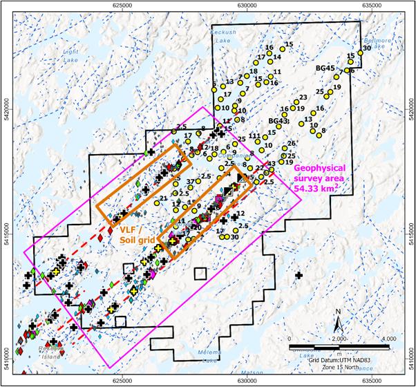
Figure 1 Sunbeam Block A showing the 54.33 km² geophysical survey area and VLF and soil sampling grids.
Marc Sale, Chief Executive Officer, commented:
"At Sunbeam, we have developed a robust exploration model through detailed geological work, disciplined fieldwork and the combined expertise of our team of industry specialists. I have worked closely with that team to build our understanding of the project, and we are confident in the model we now have and its ability to guide our exploration."
"Our collaboration with Rosor is an opportunity to build on that strong foundation. By applying AI to real exploration data, we see the potential to further enhance our understanding, sharpen our targeting and accelerate informed exploration decisions."
"This is the FCM Difference: combining geological expertise with the ambition to keep improving. Explore, Expand, Explain, Enhance captures that approach, to identify opportunities, deepen our understanding, communicate the evidence and continually strengthen how we explore. We are excited to work with Rosor to explore what this technology can add to the model we have built at Sunbeam."
About Rosor
Rosor Corp., operating as Rosor Exploration, is a Canadian airborne geophysical surveying company providing drone-based data acquisition, processing, 3D modelling and geological interpretation to support mineral exploration and drill targeting. Its capabilities include magnetic, radiometric and LiDAR surveys.
Website: https://www.rosor.ca/
|
|
|
|
|
|
|
|
About CENGN's Living Lab Initiative
CENGN (Centre of Excellence in Next Generation Networks) is a Canadian organisation supporting technology innovation and adoption. Its Living Lab Initiative provides access to specialist facilities, technical expertise and real-world testing environments to help Canadian technology companies validate their solutions and prepare them for commercial use.
Website: https://www.cengn.ca/living-lab-initiative/
For Further Information:
Engage with us by asking questions, watching video summaries, and seeing what other shareholders have to say.
Navigate to our Interactive Investor hub here:
Website: https://firstclassmetalsplc.com/link/eYO4xP
Glossary of Technical Terms
Geological, geophysical, sampling and data analysis terms used in the main announcement.
|
Term |
Explanation |
|
3D Modelling |
Creating a three-dimensional representation of geology or geophysical properties to help interpret features at and below the surface. |
|
AI / AI Workflow |
Artificial intelligence: computer-based methods used to identify patterns in data. An AI workflow combines data preparation, automated analysis and evaluation to support interpretation and exploration decisions. |
|
Alteration |
Changes to a rock's minerals or chemical composition, often caused by interaction with hot fluids. Some alteration is associated with mineralisation. |
|
Anomalies / Anomaly Detection |
A measurement or pattern that differs from the expected background. Anomaly detection identifies such features in survey or sampling data for further investigation. |
|
Contacts |
A boundary between different rock types or geological units. |
|
Data Acquisition |
The collection and recording of measurements using survey instruments or other observation methods. |
|
Drone-Based Survey |
A survey using an unmanned aircraft carrying sensors to collect measurements over an area. |
|
Exploration Model |
An interpretation of the geology and possible controls on mineralisation used to guide exploration work. |
|
Exploration Targets / Drill Targeting |
In this release, an area or geological feature selected for further investigation. Drill targeting identifies locations where drilling could test the interpretation. |
|
Geochemical Data |
Measurements of the chemical composition of rocks, soils and other natural materials, used to identify patterns that may indicate mineralisation. |
|
Geological Interpretation |
Combining geological observations, sampling results and survey data to understand rock types, structures and potential mineralisation. |
|
Geological Structures |
A feature such as a fault, fracture, fold or shear zone that may influence the location of mineralisation. |
|
Geophysical Survey / Data Processing |
Measurement of physical properties, such as magnetism or electrical conductivity, to investigate geology. Processing corrects and transforms measurements into usable maps and datasets. |
|
LiDAR |
Light Detection and Ranging, a remote sensing technique using laser pulses to measure distances and produce detailed maps of surface topography. |
|
Magnetic Survey |
A geophysical survey measuring variations in the Earth's magnetic field caused by differences in the magnetic properties of rocks. It helps map rock units, structures and contacts. |
|
Radiometric Survey |
A geophysical survey measuring naturally occurring gamma radiation, principally associated with potassium, uranium and thorium in near-surface rocks and soils. It helps map geological variations and some alteration. |
|
Rock Grab Sampling |
A rock sample collected from a selected location for examination or analysis. It may be selectively collected and may not represent the average grade of surrounding rock. |
|
Soil Sampling / Soil Sampling Grid |
Collecting soil for geochemical analysis. A soil sampling grid uses planned lines or regularly spaced locations to identify element patterns and anomalies across an area. |
|
Target Prioritisation |
Ranking exploration areas using geological, geochemical and geophysical evidence to guide follow-up work. |
|
Terrain Mapping |
Mapping the elevation, shape and physical features of the land surface. |
|
Very Low Frequency (VLF) |
An electromagnetic geophysical survey method using very low frequency radio signals from distant transmitters to detect electrically conductive features that may warrant further investigation. |
James Knowles, Executive Chair
Email: JamesK@Firstclassmetalsplc.com
Tel: 07488 362641
Marc J Sale, CEO and Executive Director
Email: MarcS@Firstclassmetalsplc.com
Tel: 07711 093532
AlbR Capital Limited (Financial Adviser)
David Coffman/Dan Harris
Website: www.albrcapital.com
Tel: (0)20 7469 0930
Axis Capital Markets (Broker)
Richard Hutchinson
Website: Axcap247.com
Tel: (0)203 026 0449
Rosor Exploration Chief Marketing Officer
Tim Peters
Email: tim@rosor.ca
Tel: +1-289-218-9600
First Class Metals PLC - Background
First Class Metals PLC listed on the LSE in July 2022 and is focused on metals exploration in Ontario, Canada which has a robust and thriving junior mineral exploration sector.
FCM currently holds 100% ownership of seven claim blocks covering over 260km² in northwest Ontario. A further three blocks are under option and cover an additional 60km². Two Joint Ventures also exist: West Pickle Lake (a drill-proven high-grade Ni-Cu project) and Zigzag
FCM is focussed on exploring for gold but has base metals and critical metals exploration projects.
The flagship properties, Sunbeam, and North Hemlo are gold focussed. North Hemlo has a significant discovery in the Dead Otter trend which is a discontinuous 3.5km gold anomalous trend with a 19.6g/t Au peak grab sample. This sampling being the highest known assay from a grab sample ever recorded on the North Limb of Hemlo.
In October 2022, FCM completed the option to purchase the historical high-grade past-producing Sunbeam gold mine near Atikokan, Ontario, ~15 km southeast of Agnico Eagle's Hammond Reef gold deposit (3.3 Moz of open pit probable gold reserves). The Sunbeam property is now 100% owned by FCM.
The Hemlo 'camp' near Marathon, Ontario is a proven world class address for gold exploration, featuring the Hemlo gold deposit previously operated by Barrick Mining (>23M oz gold produced), with the past producing Sugar Zone (>1M oz gold), Geco and Winston Lake base metal deposits also situated in the region.
FCM acquired the Zigzag Project near Armstrong, Ontario in March 2023. The property features Li-Ta-bearing pegmatites in the same belt as Green Technology Metals' Seymour Lake Project, which contains a Mineral Resource estimate of 9.9 Mt @ 1.04% Li2O. Zigzag was successfully drilled prior to Christmas 2023.FCM now owns 80% of the property and has entered into a JV with Nuinsco Resources Limited.
The significant potential of the properties for precious, base and battery metals relates to 'nearology', since all properties lie in the same districts as known deposits (Hemlo, Hammond Reef, Seymour Lake), and either contain known showings, geochemical or geophysical anomalies, or favourable structures along strike from known showings (e.g. the Esa project, with an inferred Hemlo-style shear along strike from known gold occurrences).
The Kerrs Gold property is located in northeastern Ontario within the Abitibi Greenstone Belt, one of the world's most prolific gold-producing regions. The project holds a historical inferred resource of approximately 386,000 ounces of gold, underscoring its potential as a meaningful addition to FCM's expanding gold portfolio. Kerrs Gold complements the Company's exploration strategy and provides exposure to a well-established mining district. FCM achieved 100% ownership of the property in H1 2026. In June 2026, FCM and nGRND Inc. (www.ngrnd.io) completed the closing conditions under a definitive Site Programme and Alternative Land Use Rights Agreement, establishing a non-dilutive monetisation framework while FCM retains full ownership of the project and its underlying mineral claims, together with exposure to future resource growth.
For further information see the Company's presentation on the web site:
www.firstclassmetalsplc.com
Forward Looking Statements
Certain statements in this announcement may contain forward-looking statements which are based on the Company's expectations, intentions and projections regarding its future performance, anticipated events or trends and other matters that are not historical facts. Such forward-looking statements can be identified by the fact that they do not relate only to historical or current facts. Forward-looking statements sometimes use words such as 'aim', 'anticipate', 'target', 'expect', 'estimate', 'intend', 'plan', 'goal', 'believe', or other words of similar meaning. These statements are not guarantees of statements. Given these risks future performance and are subject to known and unknown risks, uncertainties and other factors that could cause actual results to differ materially from those expressed or implied by such forward-looking and uncertainties, prospective investors are cautioned not to place undue reliance on forward-looking statements. Forward-looking statements speak only as of the date of such statements and, except as required by applicable law, the Company undertakes no obligation to update or revise publicly any forward-looking statements, whether as a result of new information, future events or otherwise.
RNS may use your IP address to confirm compliance with the terms and conditions, to analyse how you engage with the information contained in this communication, and to share such analysis on an anonymised basis with others as part of our commercial services. For further information about how RNS and the London Stock Exchange use the personal data you provide us, please see our Privacy Policy.

Latest directors dealings
- 19 minutes ago Symphony International Holdings Ltd.
- 32 minutes ago Symphony International Holdings Ltd.
- 35 minutes ago Symphony International Holdings Ltd.
- 37 minutes ago Tandem Group
- 49 minutes ago Capital for Colleagues plc