
Exploration Update, 2026 field season activities
Summary by AI BETAClose X

The information contained within this announcement is deemed to constitute inside information as stipulated under the retained EU law version of the Market Abuse Regulation (EU) No. 596/2014 (the "UK MAR") which is part of UK law by virtue of the European Union (Withdrawal) Act 2018. The information is disclosed in accordance with the Company's obligations under Article 17 of the UK MAR. Upon the publication of this announcement, this inside information is now considered to be in the public domain.

FIRST CLASS METALS PLC
05 October 2026
Exploration Update, 2026 field season activities
First Class Metals PLC ("FCM" or the "Company") the UK listed company focused on the discovery of economic metal deposits across its exploration properties in Ontario, Canada, is pleased to report the exploration progress on its properties in Ontario.
Highlights
Sunbeam property: Sunbeam - Roy & Pettigrew lineaments
· Visible gold identified in a grab sample approximately 1,100m northeast of the Roy shafts - a significant step-out from the area of visible gold previously identified in drilling at Roy. The discovery was made while prospecting a gold and lead soil anomaly close to an interpreted structural intersection identified from LiDAR data, providing further support for the emerging exploration model and highlighting the potential scale of the Roy trend. The sample has been submitted for assay.
· Pettigrew advanced towards drill targeting, with the infill channel sampling programme, Phase 1 structural mapping and Very Low Frequency ("VLF") and soil sampling surveys now completed. The VLF survey has identified a strong conductor coincident with the Pettigrew lineament. The emerging geological interpretation provides the basis for a proposed initial drill programme of approximately 1,000m, with assay results from channel and soil sampling awaited.
· Exploration footprint at Roy significantly extended, with additional VLF and soil sampling completed northeast of the existing survey area and Phase 2 structural mapping commenced. The programme is designed to further define the Roy trend and refine priority targets for follow-up drilling.
· A three year exploration permit has been granted on the Sunbeam property.
· Sunbeam drone survey ongoing, with AI collaboration non-binding letter of intent ("LOI") signed. Rosor Exploration ("Rosor") is undertaking a magnetic, radiometric and LiDAR survey covering 54.33 km² within Block A. Results will be integrated with FCM's existing VLF and geochemical data to support target prioritisation and follow-up planning. FCM has also signed a non-binding LOI to participate in Rosor's Project Field-to-Insight, using Sunbeam survey data to evaluate AI-enabled processing and geological interpretation, with the potential to accelerate exploration decisions.
Other properties
· Field programmes completed at Esa and Coco East, with assays awaited. At Esa, reconnaissance exploration targeted prospective areas approximately 11km northeast of the Hemlo gold mine, while prospecting and exploration at Coco East tested prospective geological and geophysical trends, including areas of observed sulphide mineralisation.
· Rare Earth Element ("REE") exploration underway, with prospecting initiated across FCM's two REE claim blocks.
· North Hemlo targeting being refined ahead of follow-up prospecting, with VLF data from four survey grids being reprocessed and interpreted by Simcoe Geoscience to assist in prioritising the next phase of fieldwork.
Additional project updates
· Ontario Junior Exploration Program ("OJEP") grant funding received, providing valuable non-dilutive support for the Company's exploration activities.
· Kerrs Gold resource review progressing, as the Company evaluates opportunities to advance the project.
Marc J. Sale CEO First Class Metals Commented:
"The advancement in understanding the structural controls on mineralisation at Pettigrew and Roy have been stellar, the identification of coarse visible gold in a rock sample in a predicted zone testifies to this. We now believe we have a robust hypothesis which will allow targeting of drilling at Pettigrew and by default assist further drill planning at Roy. FCM is advancing the exploration of its portfolio on many fronts from Esa in the east to the Pathfinder REE block in the west.
We await the assays results of the work not only from these areas but also the VG discovered northeast of the Roy shaft. The fact that this VG was found as a result of prospecting anomalous soils with structural input from the LiDAR study is a very important, very positive, development for expanding the exploration across the whole Sunbeam property."
Follow the link to find an explanatory video https://firstclassmetalsplc.com/link/yVdgQr
Advances at Pettigrew
Using a virtual grid of ~4km strike, a VLF survey over a total of 33-line km was initiated and completed, see Figure 1. Cross lines were spaced 100m and up to 800m long with stations at 12.5m for about 2700 stations on 41 lines. This detailed, comprehensive survey is intended to replicate the information generated at Roy.
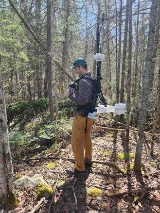
Figure 1 showing collecting VLF data at Pettigrew
The initial interpretation of the VLF results has highlighted a very robust conductor mimicking to the Pettigrew lineament. The conductor runs the length of the survey area indicating it remains open along strike in both directions. The survey also shows that there are intersecting conductors supporting the presence of some of the LiDAR trends, see Figure 2. These developments in the understanding of the structure and geology are integral to the emerging geological / mineralisation model.
A soil sample survey using the same spacing, but on shorter cross lines, collected 431 soil samples. These have been dispatched to the laboratory in Thunder Bay and assays are awaited.
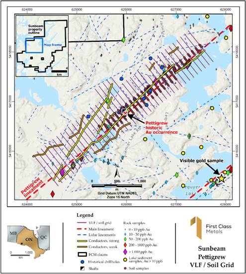
Figure 2 showing map of the VLF and soil grid over the Pettigrew lineament, centred on the old shaft area
Under the guidance of consultant geologist Chris Cooper an infill (including several duplicates) channel sampling programme was design for the Pettigrew stripped area. In total 58.95m of channels were cut producing 93 samples, assays awaited.
Recent geological mapping and structural interpretation has significantly enhanced FCM's understanding of the Pettigrew prospect, see Figure 3. The mapping has provided a basis for a short drill programme, circa 1,000m. The thickening of the 'stress' in the vicinity of the shafts is reminiscent of the wider mineralised zone seen in the Roy drilling containing the visible gold.
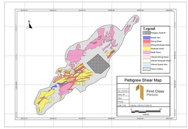
Figure 3 showing structural mapping at Pettigrew stripped area created by Brenden, geologist with Emerald Geological Services ('EGS')
Ongoing exploration at Roy
The work at Roy has extended the original VLF survey grid of 22.7 line-km to the northeast by a further 18.4 line-km. There are an additional 21 lines with 100m line spacing and 12.5m station spacing, in total about 1500 new stations. Interpretation of the results and merging of the existing VLF surveys are underway.
Previous work has shown that the incidence of Au (gold) and Pb (lead) can represent potential for increased gold mineralisation along the Roy trend. Accordingly using the same virtual grid, the soil sampling programme was also extended to the northeast, with a further 156 soil samples taken over 13 lines augmenting the original 491 samples, assays awaited.
The total coverage of the VLF and soil sampling programme is almost 5km of strike from the Roy shafts, see Figure 4.
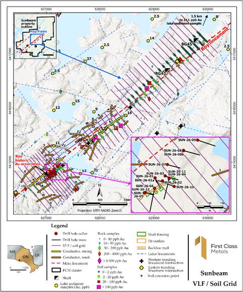
Figure 4 Showing the initial VLF / soil survey at Roy and the extended survey NE.
This growing understanding of the structural controls on mineralisation at Pettigrew and the model emerging is being used to further enhance the structural 'picture' at Roy. An intensive, detailed mapping of previously stripped area focussing on structure is ongoing.
The emerging geological model at Roy and ongoing work around the Pettigrew shafts and pits will be collated to form the basis of a drill proposal at Pettigrew as well as recommendations for follow up drilling at Roy.
Exploration at Roy and Pettigrew following up on VLF and soil anomalies
Prospecting of the soil sample generated anomalies has started on both the Roy and Pettigrew grids. To date 73 grab samples have been collected at Roy as part of an ongoing programme and are with the laboratory for analyses. One sample roughly 1100m northeast of the Roy shafts contains visible gold see Figures 5 and Figure 6. The gold content was confirmed by a handheld XRF scan.
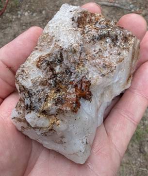
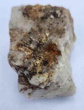
Figure 5 showing the VG - visible gold from northeast of the Roy drilling.
This is an extremely significant development in the exploration of the Roy trend and the Sunbeam property as a whole.
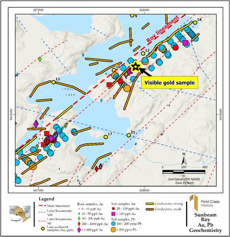
Figure 6 showing the location of the VG on the Roy prospect. Importantly, note coincident soil anomaly on the Roy trend, and intersecting LiDAR structure.
The discovery of gold a significant distance from the visible gold seen in drill holes at Roy further supports the current geological model. More so as it is at the coincidence of Au and Pb soil anomalies as well as importantly where the west-northwest LiDAR-identified-structures are interpreted to intersect the Roy lineament. This is also an important development for targeting future exploration.
This very positive advance in the model being proposed for the property wide exploration. Furthermore, it justifies the approach being used by FCM in the exploration of the Sunbeam property.
Prospecting has also started on the soil grid at Pettigrew, see Figure 7, following up on historical gold occurrences.
To date 23 samples have been collected and are awaiting analyses.
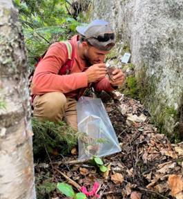
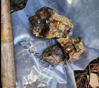
Figure 7 showing samples collected NE of the Pettigrew shaft.
An Exploration permit application lodged with the Ministry of Mines was recently confirmed as being granted. The permit allows for clearing of a baseline at Roy and Pettigrew as well as stripping at a number of locations. Importantly the drilling on both the Roy / Pettigrew lineaments and their extensions are allowed.
The permit is valid for three years.
Unravelling the greater Sunbeam property block potential
FCM has engaged Rosor Exploration, a renowned Toronto based, international geophysics company, to undertake a detailed geophysics survey over the central area of the Sunbeam property to commence late September. It is intended that the interpretation will include the ground-based VLF as well as the soil data from both Roy and Pettigrew. See Figure 8 for the survey area.
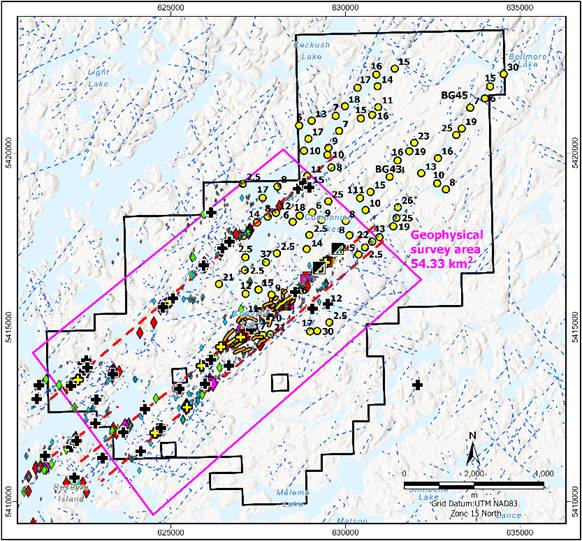
Figure 8 showing the area of the Drone aerial geophysics survey
The Rosor survey will assist in the overall planning for exploration on the Sunbeam property.
As announced in more detail in the RNS Reach dated 2 October 2026, FCM has signed a non-binding Letter of Intent to participate as an industry adopter in Rosor's Project Field-to-Insight, an AI-enabled exploration initiative under CENGN's Living Lab programme. The proposed collaboration will use data from the ongoing Sunbeam survey to evaluate automated geophysical processing and AI-assisted geological interpretation against conventional survey deliverables. The aim is to assess whether these technologies can accelerate target identification and prioritisation, complementing FCM's existing geological model and exploration methods.
Ahead of the results however, in-house studies of the historic work, geology, and geophysics supplemented by the recent LiDAR survey, have shown a number of very prospective areas on the property for further exploration. Including what could be a previously unidentified, parallel trend to the east of the Sunbeam lineament, see Figure 9.
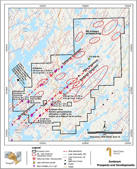
Figure 9 showing the Sunbeam property with potential new areas of exploration based on the Lineament / LiDAR intersection model
Exploration at Esa
Prospecting on the Esa claim block focussed on enhancing identified areas of anomalism and potential. Primarily the area around the 700ppb boulder which displays similarity to the quartz eye porphyry at Hemlo. In total 11 'till' samples were collected, see Figure 10 on the 8 contiguous claims in a rough grid.
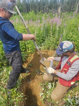
Figure 10 showing collecting 'Till' samples
In the central sector of the claim block, in the area of the previous soil sampling, a test line of 5 samples
were collected over what was identified as a rare earth anomaly in the previous survey.
Prospecting in both areas resulted in 14 additional grab samples. All samples have been submitted for assay.
The work conducted will ensure the Esa block is in good standing to late 2027.
Exploration on the Coco East claim block
'Coco' is interpreted to contain the extension of the Big Duck lake porphyry which contains the Coco Estelle gold deposit, see Figure 11. The geophysical anomaly in the north has also been interpreted as the extension of the zinc structure historically exploited at the Pick Zinc mine, roughly 10km to the west.
Brenden Kanan, the EGS geologist in charge of the exploration programme reported: 'the strongest trend encountered during the program was a chalcopyrite, pyrite, and malachite-stained mineralised zone south of Big Duck Lake on the northwest claims. This trend was proximal to a mapped porphyry by Falconbridge. This area was well mineralised along both sides of the trend (north and south), with the northern contact zone coinciding with a hill/small cliff that had a large amount of exposed outcrop for at least half a kilometre (and possibly more).
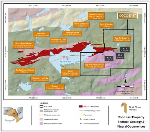
Figure 11 showing the Coco claim with the Big Duck lake porphyry and the geophysical anomaly.
Samples of mainly outcrop and some local angular floats were taken, including quartz porphyry containing pyrite and chalcopyrite, amphibolite schist with chalcopyrite and lesser pyrite, strongly to moderately magnetic mafic intrusive with chalcopyrite, pyrite and malachite staining. In total 34 samples were collected and are awaiting final analyses, see Figure 12.
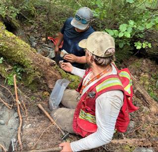
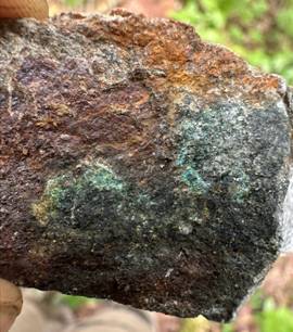
Figure 12 showing sampling and an example of a sample 'bagged'.
The trend remains open along strike within the property.
REE properties
Exploration / prospecting has commenced at both the Scotch Lake and Pathfinder properties. Whilst in its early stages a number of pegmatitic or pegmatite associated rock samples have been collected, see Figure 13. The exploration is ongoing and subject to results there will be follow up programme.
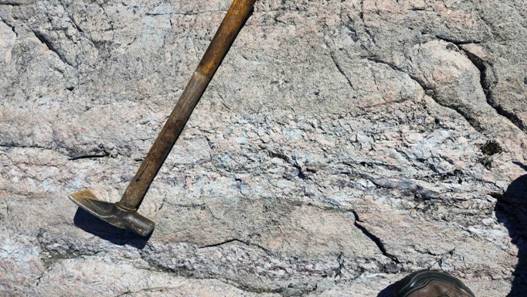
Figure 13 showing Pegmatitic dykes in granitic host rock
OJEP
FCM applied for the '7th' intake' of the OJEP in 2025-2026 and was notified of a successful grant in March 2026. Subsequently a sum of $132,972.76 was received from the Ontario government. These funds are a welcome non-dilutive addition to the exploration budget.
Kerrs
A brief field visit to the Kerrs property was undertaken to assess access, which was generally good to the resource area. A significant development was the discovery of one of the drill holes on the eastern central portion of the Resource area, see Figure 14.
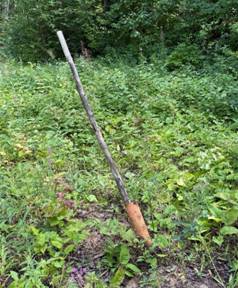
Figure14 showing historic drill collar
The casing bore no identifying markings, so the drill hole it represents cannot be confirmed, though it most likely lies in the north-central part of the resource drilling area (Figure 15).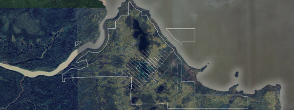
Figure 15 showing the drill hole location plan from the 2011 Kerrs NI 43-101 resource study.
The update of the resource is ongoing, making positive progress and will be announced when concluded.
Qualified Person
The technical disclosures contained in this announcement have been drafted in line with the Canadian Institute of Mining, Metallurgy and Petroleum standards and guidelines and approved by Marc J. Sale, who has more than 30 years in the gold exploration industry and is considered a Qualified Person owing to his status as a Fellow of the Australian Institute of Mining and Metallurgy.
Glossary of Technical Terms
This glossary defines geological, drilling, sampling and geophysical terms used in mineral exploration reporting.
|
Term |
Explanation |
|
Alteration |
Chemical changes to rock caused by mineralising fluids, often associated with ore-forming processes. |
|
Assay |
Laboratory analysis used to determine the concentration of metals within a rock sample. |
|
Azimuth |
The compass direction in which a drill hole or geological feature is oriented, measured in degrees from north. |
|
Core |
Cylindrical rock recovered during diamond drilling, used to examine geology and mineralisation. |
|
Diamond Drill Hole (DDH) |
A hole drilled using a diamond drill bit to recover continuous rock core for geological logging, sampling and analysis. |
|
Fire Assay (FA) |
The industry-standard laboratory method that uses high-temperature fusion to separate and concentrate precious metals, such as gold and silver, for accurate measurement. Typically, only a small sub-sample (commonly 50 g) is analysed. |
|
Galena |
A lead sulphide mineral (PbS) that can be associated with precious metal mineralisation in some geological systems. |
|
LiDAR |
Light Detection and Ranging, a remote sensing technique that uses laser pulses to produce highly detailed maps of surface topography. |
|
Logging |
The detailed geological description and recording of drill core, including rock type, alteration and mineralisation. |
|
Mineralised Package |
A sequence of rocks containing minerals associated with potential economic metal deposits. |
|
Photon Assay (PA) |
A non-destructive analytical method that measures the gold content of an entire sample using photon activation, reducing sampling bias associated with coarse or visible gold. |
|
Quartz Vein |
A fracture or crack in rock that has been filled with quartz. Quartz veins are commonly associated with gold mineralisation. |
|
Sampling |
The process of cutting and collecting sections of drill core for laboratory analysis to determine metal content. |
|
Schist |
A metamorphic rock characterised by strong foliation and aligned mineral grains. |
|
Strike |
The compass direction of a geological feature, such as a vein or shear zone, measured along its horizontal extent. |
|
Strike Length |
The horizontal distance over which a geological structure or mineralised zone can be traced. |
|
Structure / Structural Zone |
A geological feature, such as a fault or shear zone, that may control the movement of mineralising fluids and the location of mineral deposits. |
|
Till Sample |
A sample of unconsolidated glacial sediment collected to identify mineral grains or geochemical anomalies that may indicate mineralisation in the underlying or nearby bedrock. |
|
Tonalite |
A coarse-grained intrusive igneous rock similar to granite, commonly found in mineralised geological terranes. |
|
Very Low Frequency (VLF) |
A ground or airborne electromagnetic geophysical survey method that uses very low frequency radio signals from distant transmitters to detect conductive geological features, such as faults, shear zones or sulphide-bearing zones, that may be associated with mineralisation. |
|
Visible Gold (VG) |
Gold that can be seen with the naked eye in drill core or rock samples. Visible gold does not necessarily indicate economic grades but is considered a positive indicator in gold exploration. |
For Further Information:
Engage with us by asking questions, watching video summaries, and seeing what other shareholders have to say. Navigate to our Interactive Investor hub here: https://firstclassmetalsplc.com/link/yVdgQr
For further information, please contact:
James Knowles, Executive Chair
Email: JamesK@Firstclassmetalsplc.com
Tel: 07488 362641
Marc J Sale, CEO and Executive Director
Email: MarcS@Firstclassmetalsplc.com
Tel: 07711 093532
AlbR Capital Limited (Financial Adviser)
David Coffman/Dan Harris
Website: www.albrcapital.com
Tel: (0)20 7469 0930
Axis Capital Markets (Broker)
Richard Hutchinson
Website: Axcap247.com
Tel: (0)203 026 0449
First Class Metals PLC - Background
First Class Metals PLC listed on the LSE in July 2022 and is focused on metals exploration in Ontario, Canada which has a robust and thriving junior mineral exploration sector.
FCM currently holds 100% ownership of seven claim blocks covering over 260km² in northwest Ontario. A further three blocks are under option and cover an additional 60km². Two Joint Ventures also exist: West Pickle Lake (a drill-proven high-grade Ni-Cu project) and Zigzag.
FCM is focussed on exploring for gold but has base metals and critical metals exploration projects.
The flagship properties, Sunbeam, and North Hemlo are gold focussed. North Hemlo has a significant discovery in the Dead Otter trend which is a discontinuous 3.5km gold anomalous trend with a 19.6g/t Au peak grab sample. This sampling being the highest known assay from a grab sample ever recorded on the North Limb of Hemlo.
In October 2022, FCM completed the option to purchase the historical high-grade past-producing Sunbeam gold mine near Atikokan, Ontario, ~15 km southeast of Agnico Eagle's Hammond Reef gold deposit (3.3 Moz of open pit probable gold reserves). The Sunbeam property is now 100% owned by FCM.
The Hemlo 'camp' near Marathon, Ontario is a proven world class address for gold exploration, featuring the Hemlo gold deposit previously operated by Barrick Mining (>23M oz gold produced), with the past producing Sugar Zone (>1M oz gold), Geco and Winston Lake base metal deposits also situated in the region.
FCM acquired the Zigzag Project near Armstrong, Ontario in March 2023. The property features Li-Ta-bearing pegmatites in the same belt as Green Technology Metals' Seymour Lake Project, which contains a Mineral Resource estimate of 9.9 Mt @ 1.04% Li2O. Zigzag was successfully drilled prior to Christmas 2023.FCM now owns 80% of the property and has entered into a JV with Nuinsco Resources Limited.
The significant potential of the properties for precious, base and battery metals relates to 'nearology', since all properties lie in the same districts as known deposits (Hemlo, Hammond Reef, Seymour Lake), and either contain known showings, geochemical or geophysical anomalies, or favourable structures along strike from known showings (e.g. the Esa project, with an inferred Hemlo-style shear along strike from known gold occurrences).
The Kerrs Gold property is located in northeastern Ontario within the Abitibi Greenstone Belt, one of the world's most prolific gold-producing regions. The project holds a historical inferred resource of approximately 386,000 ounces of gold, underscoring its potential as a meaningful addition to FCM's expanding gold portfolio. Kerrs Gold complements the Company's exploration strategy and provides exposure to a well-established mining district. FCM achieved 100% ownership of the property in H1 2026. In June 2026, FCM and nGRND Inc. (www.ngrnd.io) completed the closing conditions under a definitive Site Programme and Alternative Land Use Rights Agreement, establishing a non-dilutive monetisation framework while FCM retains full ownership of the project and its underlying mineral claims, together with exposure to future resource growth.
For further information see the Company's presentation on the web site:
www.firstclassmetalsplc.com
Forward Looking Statements
Certain statements in this announcement may contain forward-looking statements which are based on the Company's expectations, intentions and projections regarding its future performance, anticipated events or trends and other matters that are not historical facts. Such forward-looking statements can be identified by the fact that they do not relate only to historical or current facts. Forward-looking statements sometimes use words such as 'aim', 'anticipate', 'target', 'expect', 'estimate', 'intend', 'plan', 'goal', 'believe', or other words of similar meaning. These statements are not guarantees of statements. Given these risks future performance and are subject to known and unknown risks, uncertainties and other factors that could cause actual results to differ materially from those expressed or implied by such forward-looking and uncertainties, prospective investors are cautioned not to place undue reliance on forward-looking statements. Forward-looking statements speak only as of the date of such statements and, except as required by applicable law, the Company undertakes no obligation to update or revise publicly any forward-looking statements, whether as a result of new information, future events or otherwise.
RNS may use your IP address to confirm compliance with the terms and conditions, to analyse how you engage with the information contained in this communication, and to share such analysis on an anonymised basis with others as part of our commercial services. For further information about how RNS and the London Stock Exchange use the personal data you provide us, please see our Privacy Policy.

Latest directors dealings
- 50 minutes ago Wellnex Life Limited
- 1 hour ago Keras Resources
- 1 hour ago DP Poland
- 1 hour ago Gemfields Group Limited
- 2 days ago Legal & General Group