VMS Drilling Update
Summary by AI BETAClose X
22 December 2025
East Star Resources Plc
("East Star" or the "Company")
VMS Drilling Update
Results from Rulikha North and Talovskoye confirm mineralisation within expected lithologies, and improve targeting for 2026 drilling
East Star Resources Plc (LSE:EST), the Kazakhstan-focused gold and base metals explorer, is pleased to provide an update on drilling activities which have been completed at the Rulikha North and Talovskoye West targets.
Highlights
|
· |
120m of disseminated sulphides, including 90m @ >20% pyrite at Rulikha North |
|
· |
Footwall stringer zones indicating proximity to a massive sulphide source |
|
· |
Follow up work programmes planned in 2026 |
Alex Walker, East Star CEO, commented:
"We have identified a fertile hydrothermal cell at Rulikha North, which shows that there is a large system, requiring further exploration. We're excited to follow up on this target in 2026 in the hope of delineating another ore body in this hugely productive and underexplored region.
Whilst clearly further away from the source, the Talovskoye target did intersect mineralisation and, based on the proximity to past producing mines, further exploration work remains justified.
We are excited to explore these targets further for a massive sulphide source with geophysics and, if those results are positive, follow up with drilling in 2026. Our East Region VMS strategy is producing encouraging exploration results, and we've now started to demonstrate that positive results can be monetised, as per our recently announced JV agreement for the development of Verkhuba."
Rulikha North
Drill hole RU_25_DD001 is located 1.6 km north of the Rulikha Deposit and tested the centre of the chargeability anomaly to a depth of 400m. Drilling confirmed that the Rulikha North IP anomaly does contain disseminated sulphides and stringer veinlets with minor Zn-Pb (+Cu) mineralisation. The results include three important horizons:
|
· |
Increased Cu horizon - 195.00 - 210.00m at 456 ppm Cu (background copper is 65 ppm) |
|
· |
Zn-Pb stringer - 350 -392m at 0.5% Pb, 0.8% Zn and 339 ppm Cu |
|
· |
Zn stringer - 390-392.00m at 0.27% Zn |
These results confirm the presence of a large 1.5 x 1.0 km hydrothermal alteration cell, previously outlined by the Company in its announcement on 13 May 2025 (Figure 1).

Figure 1: Plan view showing the large extent of the Rulikha North and Talovskoye IP anomalies
These hydrothermal alteration cells are a requisite for a VMS deposit to form. In addition to the disseminated sulphides, East Star noted alteration and stringer veins typical of the style of mineralisation expected immediately adjacent to a massive sulphide ore body (Figure 2).
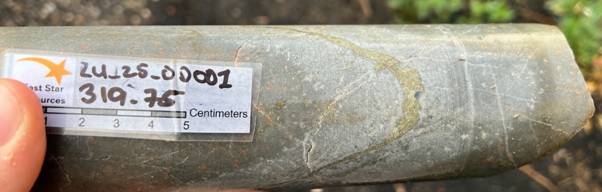
Figure 2: Stringer pyrite veins with sericite alteration observed at 319.75 m
The initial geological interpretation indicates that a fertile system has been intersected, but the source of the sulphides was not intersected; therefore, the drill hole is proximal to a potential VMS-style deposit (Figure 3). As such, the results provided the confirmation that East Star required from this phase of drilling, including confirming mineralisation within the expected lithologies as well as demonstrating proximal alteration signatures. Additional exploration is therefore warranted with the likely exploration programme to include a ground electromagnetic ("EM") survey, aimed at directly targeting the massive sulphides within the system.
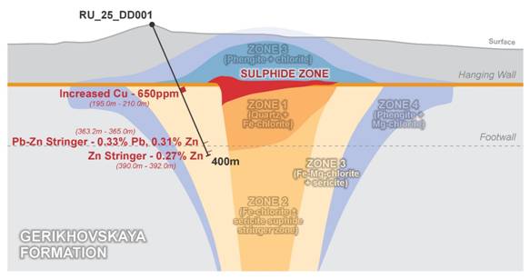
Figure 3: Exploration concept and East Star's interpretation of the Rulikha North anomaly. Zone 1 - 4 represents the footprint of the hydrothermal cell (note alternative geological interpretations may exist, and further work is needed to confirm the presence of mineralisation)
Talovskoye West
Drilling at Talovskoye West was completed with a single drillhole (TAL_25_DD001) drilled to a depth of 305.50m. This hole aimed to test a discrete IP chargeability anomaly, previously outlined by the Company in its announcement on 15 May 2025 (Figure 1).
The hole intersected volcaniclastic and breccia lithologies with minor alteration associated with stringer veinlets of sulphides. The hole did intersect a small, mineralised interval - 265.10 to 265.90m at 0.8 % Zn, 0.37 % Pb and 0.3% Cu. The sulphide content combined with relatively small alteration intervals indicate that the footwall alteration pattern was not intersected (Figure 4). The Company views the anomaly as unresolved and additional geophysics, likely to include ground EM, are required to determine the location of any potential massive sulphides in the system.
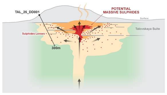
Figure 4: Exploration concept and East Star's interpretation of the Talovskoye West anomaly
East Star Resources Plc
Alex Walker, Chief Executive Officer
Tel: +44 (0)20 7390 0234 (via Vigo Consulting)
SI Capital (Corporate Broker)
Nick Emerson
Tel: +44 (0)1483 413 500
Vigo Consulting (Investor Relations)
Ben Simons / Peter Jacob
Tel: +44 (0)20 7390 0234
About East Star Resources Plc
East Star Resources is focused on the discovery and development of copper and gold in Kazakhstan. The Company is pursuing multiple exploration strategies including:
|
· |
A joint venture with Hong Kong Xinhai Mining Services Limited to take the Verkhuba Deposit (20.3Mt @ 1.16% copper, 1.54% zinc and 0.27% lead) into production (at no further cost to East Star) with East Star retaining 30% ownership in production |
|
· |
A second VMS Exploration Target with up to 23Mt @ 2.4% copper equivalent in the same region, with numerous other targets being advanced to drill-ready status |
|
· |
A $25 million+ strategic gold exploration joint venture with Endeavour Mining |
|
· |
Tier 1 potential copper porphyry targets and epithermal gold targets in a proven copper porphyry and epithermal belt |
Visit our website:
Follow us on social media:
LinkedIn: https://www.linkedin.com/company/east-star-resources/
X (formerly Twitter): https://twitter.com/EastStar_PLC
Subscribe to our email alert service to be notified whenever East Star releases news:
www.eaststarplc.com/newsalerts
The person who arranged for the release of this announcement was Alex Walker, CEO of the Company.
This announcement contains inside information for the purposes of Article 7 of Regulation 2014/596/EU which is part of domestic UK law pursuant to the Market Abuse (Amendment) (EU Exit) Regulations (SI 2019/310) ("UK MAR"). Upon the publication of this announcement, this inside information (as defined in UK MAR) is now considered to be in the public domain.
Competent Person Statement
Scientific or technical information in this disclosure related to exploration was reviewed by Dr Tremain Woods, a full-time employee of Discovery Ventures Kazakhstan Ltd, a 100% owned subsidiary of East Star Resources PLC. Dr Woods is a member in good standing with the Geological Society of South Africa. He has sufficient experience that is relevant to the commodity, style of mineralisation or type of deposit under consideration and activity which he is undertaking to qualify as a Competent Person under the JORC code (2012 Edition).
Table 1 Drill Collars and Results
Collars
|
Target |
Hole ID |
Drilling Type |
Max Depth |
Easting |
Northing |
Elevation |
Coordinate System |
|
Rulikha North |
RU_25_DD_001 |
DD |
400.3 |
570837 |
5594804 |
561 |
WGS84_44N |
|
Talovskoye West |
TAL_25_DD_001 |
DD |
305.5 |
570293 |
5595599 |
440 |
WGS84_44N |
Significant Intercepts
|
Hole_ID |
Depth From |
Depth To |
Lab Method |
Cu_ppm |
Au_ppm |
Ag_ppm |
Pb_ppm |
Zn_ppm |
|
TAL_25_DD_001 |
198.8 |
199.4 |
ME-ICP41 |
429 |
|
2.2 |
2950 |
4340 |
|
TAL_25_DD_001 |
210.2 |
210.8 |
ME-ICP41 |
196 |
|
0.7 |
355 |
1650 |
|
TAL_25_DD_001 |
265.1 |
265.9 |
ME-ICP41 |
3160 |
|
4.3 |
3730 |
8560 |
|
TAL_25_DD_001 |
285.6 |
287.7 |
ME-ICP41 |
65 |
|
2.2 |
749 |
1255 |
|
TAL_25_DD_001 |
287.7 |
288.2 |
ME-ICP41 |
541 |
|
5.8 |
1070 |
9090 |
|
RU_25_DD_001 |
48 |
50 |
ME-ICP41 |
337 |
0.001 |
0.3 |
16 |
44 |
|
RU_25_DD_001 |
195 |
200 |
ME-ICP41 |
692 |
0.005 |
0.6 |
32 |
185 |
|
RU_25_DD_001 |
200 |
205 |
ME-ICP41 |
667 |
0.002 |
0.7 |
30 |
130 |
|
RU_25_DD_001 |
274.1 |
277.5 |
ME-ICP41 |
88 |
-0.001 |
0.7 |
1180 |
1565 |
|
RU_25_DD_001 |
300.1 |
305 |
ME-ICP41 |
237 |
0.005 |
0.6 |
65 |
2110 |
|
RU_25_DD_001 |
349.8 |
350.3 |
ME-ICP41 |
220 |
-0.001 |
2 |
5210 |
8360 |
|
RU_25_DD_001 |
363.2 |
364.1 |
ME-ICP41 |
554 |
0.004 |
2.6 |
4540 |
3250 |
|
RU_25_DD_001 |
364.1 |
365 |
ME-ICP41 |
264 |
0.003 |
1.4 |
2070 |
2940 |
|
RU_25_DD_001 |
390 |
392 |
ME-ICP41 |
321 |
0.002 |
3.9 |
663 |
2680 |
Table 2 - JORC Code, 2012 Edition
Section 1 Sampling Techniques and Data
|
Criteria |
JORC Code explanation |
Commentary |
|
Sampling techniques |
· Nature and quality of sampling (e.g. cut channels, random chips, or specific specialised industry standard measurement tools appropriate to the minerals under investigation, such as down hole gamma sondes, or handheld XRF instruments, etc). These examples should not be taken as limiting the broad meaning of sampling. · Include reference to measures taken to ensure sample representivity and the appropriate calibration of any measurement tools or systems used. · Aspects of the determination of mineralisation that are Material to the Public Report. · In cases where 'industry standard' work has been done this would be relatively simple (e.g. 'reverse circulation drilling was used to obtain 1 m samples from which 3 kg was pulverised to produce a 30 g charge for fire assay'). In other cases, more explanation may be required, such as where there is coarse gold that has inherent sampling problems. Unusual commodities or mineralisation types (e.g. submarine nodules) may warrant disclosure of detailed information. |
· Samples were taken from diamond drill core through sulphide or oxide mineralised intervals. · Half-core was sampled. · Sampling intervals ranged from 1.0 m to 5.0 m. Samples with no visible sulphides were composited into 5 m composites. · Sample quality was ensured by adding blanks at the beginning and end of any sulphide mineralised sequences, regular coarse duplicates (every 50th sample) and CRMs (every 40th sample) were inserted into the sample stream · The entire drill hole was sampled · Samples were prepared at ALS Karaganda · The remaining half core and sample pulps are stored at East Star's Verkhuba facilities
|
|
Drilling techniques |
· Drill type (e.g. core, reverse circulation, open-hole hammer, rotary air blast, auger, Bangka, sonic, etc) and details (e.g. core diameter, triple or standard tube, depth of diamond tails, face-sampling bit or other type, whether core is oriented and if so, by what method, etc). |
· Drilling was conducted using standard HQ sized diamond drilling technique. · Core was orientated using the RELFEX Act II orientation tool |
|
Drill sample recovery |
· Method of recording and assessing core and chip sample recoveries and results assessed. · Measures taken to maximise sample recovery and ensure representative nature of the samples. · Whether a relationship exists between sample recovery and grade and whether sample bias may have occurred due to preferential loss/gain of fine/coarse material. |
· Core recovery was an average of 91%, the total range was from 20 - 100% recovery · No relationship exists between mineralisation and core recovery |
|
Logging |
· Whether core and chip samples have been geologically and geotechnically logged to a level of detail to support appropriate Mineral Resource estimation, mining studies and metallurgical studies. · Whether logging is qualitative or quantitative in nature. Core (or costean, channel, etc) photography. · The total length and percentage of the relevant intersections logged. |
· Core was logged by EST geologists into excel datasheets and imported into EST's database · EST's database is maintained by Rock Solid in Perth, Australia · Logging is completed visually with the guidance of the Exploration Manager, details of core recovery, lithology, mineralisation, alteration, structures, veining, oxidation and weathering are captured. · All core was logged, sampled and photographed |
|
Sub-sampling techniques and sample preparation |
· If core, whether cut or sawn and whether quarter, half or all core taken. · If non-core, whether riffled, tube sampled, rotary split, etc and whether sampled wet or dry. · For all sample types, the nature, quality, and appropriateness of the sample preparation technique. · Quality control procedures adopted for all sub-sampling stages to maximise representivity of samples. · Measures taken to ensure that the sampling is representative of the in-situ material collected, including for instance results for field duplicate/second-half sampling. · Whether sample sizes are appropriate to the grain size of the material being sampled. |
· Half core samples were collected for processing. · Samples were collected in sample bags and sent to ALS Ust Kamenogorsk for sample preparation · ALS sample preparation technique involves drying (at >100°C for rocks), fine crushing to 70% passing <2mm, riffle splitting a 250g subsample, and pulverizing to better than 85% passing 75 microns; it is a high-quality, standard method appropriate for geochemistry analysis of drill core, rock, and chip samples to produce homogeneous subsamples · Quality control procedures in at ALS include internal verifications at each size reduction stage to confirm particle size specifications, cleaning equipment with clean rock, silica, and compressed air between samples to prevent carryover, and availability of QC data via Webtrieve™ to maximize sample representivity during sub-sampling · Coarse duplicates were selected every 50th sample to verify samples representivity · Sample sizes were deemed appropriated for the material being sampled · Sample pulps will be returned to EST for storage at the Verkhuba facility |
|
Quality of assay data and laboratory tests |
· The nature, quality and appropriateness of the assaying and laboratory procedures used and whether the technique is considered partial or total. · For geophysical tools, spectrometers, handheld XRF instruments, etc, the parameters used in determining the analysis including instrument make and model, reading times, calibrations factors applied and their derivation, etc. · Nature of quality control procedures adopted (e.g. standards, blanks, duplicates, external laboratory checks) and whether acceptable levels of accuracy (i.e. lack of bias) and precision have been established. |
· Samples were analysed using the ME-ICP41 method. Samples were analysed by aqua regia digestion of 0.5g samples aliquots for partial extraction, followed by ICP-AES multi-element analysis (up to 35 elements like Cu, Pb, Zn, Ag, As, Mo; detection limits 0.01 ppm). The method has good enough accuracy for detecting ore mineral concentrations. Over limits samples (>10,000 ppm) were analysed again using the Cu-OG46 method (up to 50% Cu, Pb and Zn detection limit. · EST used a standard QA/QC system to check the nature and quality of analyses. Blanks were inserted at the beginning and end of mineralised intervals, CRMS were inserted every 50th sample and coarse duplicates were selected for every 40th sample. Results were statistically analysed and were found to be sufficiently accurate |
|
Verification of sampling and assaying |
· The verification of significant intersections by either independent or alternative company personnel. · The use of twinned holes. · Documentation of primary data, data entry procedures, data verification, data storage (physical and electronic) protocols. · Discuss any adjustment to assay data. |
· No independent verification of significant intersections has been completed at this stage · No holes have been twinned · All data is collected electronically and stored on EST's cloud storage solution · No adjustments have been made to the assay data |
|
Location of data points |
· Accuracy and quality of surveys used to locate drill holes (collar and down-hole surveys), trenches, mine workings and other locations used in Mineral Resource estimation. · Specification of the grid system used. · Quality and adequacy of topographic control. |
· Drill holes were surveyed using Garmin GPSMAP 62S handheld GPS device. DGPS surveys are planned once all drilling is completed. · Grid system WGS84, UTM42N. · Topographic control is sufficient for early stage exploration |
|
Data spacing and distribution |
· Data spacing for reporting of Exploration Results. · Whether the data spacing and distribution is sufficient to establish the degree of geological and grade continuity appropriate for the Mineral Resource and Ore Reserve estimation procedure(s) and classifications applied. · Whether sample compositing has been applied. |
· Holes are spaced according to exploration requirements · Drill spacing is not sufficient for resource estimation · Samples were composited. Individual 1 m samples were submitted to ALS. After sample preparation, a sample aliquot was taken for 1 m samples and combined until homogenous by ALS. An aliquot of the composited sample was analysed. Samples with visible sulphide mineralisation were sampled at 1 m intervals. |
|
Orientation of data in relation to geological structure |
· Whether the orientation of sampling achieves unbiased sampling of possible structures and the extent to which this is known, considering the deposit type. · If the relationship between the drilling orientation and the orientation of key mineralized structures is considered to have introduced a sampling bias, this should be assessed and reported if material. |
· Not applicable at this stage of exploration |
|
Sample security |
· The measures taken to ensure sample security. |
· Sample security is maintained by East Star geologists until delivered to the ALS laboratory |
|
Audits or reviews |
· The results of any audits or reviews of sampling techniques and data. |
· No audits were undertaken for this work. |
Section 2 Reporting of Exploration Results
|
Criteria |
JORC Code explanation |
Commentary |
|||||||||||||||||||||||||||||||||||||||||||||||||||||
|
Mineral tenement and land tenure status |
· Type, reference name/number, location and ownership including agreements or material issues with third parties such as joint ventures, partnerships, overriding royalties, native title interests, historical sites, wilderness or national park and environmental settings. · The security of the tenure held at the time of reporting along with any known impediments to obtaining a licence to operate in the area. |
· The Rulikha North IP anomaly Deposit is partially located in the eastern part of exploration license 1799-EL (the "License"). The license was issued to Rudny Resources Limited on 28 July 2022 for initial period of 6 years with a possibility of further five years extension subject to reduction of the license area by 40%. · East Star resources have servitude for exploration from the local Akim (administrative head), and local landholders, over some areas within the Licence and the license can be explored under these agreements. · Some other areas within the Licence are restricted in access due to hydrogeological constraints. Additional permission will be required to gain access to drill within these areas. · There are no known legal or security impediments to obtaining a mining license. |
|||||||||||||||||||||||||||||||||||||||||||||||||||||
|
Exploration done by other parties |
· Acknowledgment and appraisal of exploration by other parties. |
· Table of previously completed exploration
|
|||||||||||||||||||||||||||||||||||||||||||||||||||||
|
Geology |
· Deposit type, geological setting, and style of mineralisation. |
· The deposit type being explored is Volcanogenic Massive Sulphide (VMS) deposit. Historical reports indicate that the type is felsic bimodal (or Kuroko-type). · Nearby mineralization is lenticular massive and disseminated sulphides hosted in volcaniclastic units sub horizontal units. · The area has seen post depositional deformation in the form of folding and faulting |
|||||||||||||||||||||||||||||||||||||||||||||||||||||
|
Drill hole Information |
· A summary of all information material to the understanding of the exploration results including a tabulation of the following information for all Material drill holes: o easting and northing of the drill hole collar o elevation or RL (Reduced Level - elevation above sea level in metres) of the drill hole collar o dip and azimuth of the hole o down hole length and interception depth o hole length. · If the exclusion of this information is justified on the basis that the information is not Material and this exclusion does not detract from the understanding of the report, the Competent Person should clearly explain why this is the case. |
· See table 1 for drill hole information and significant intercepts · No material information has been excluded from this report |
|
||||||||||||||||||||||||||||||||||||||||||||||||||||
|
Data aggregation methods |
· In reporting Exploration Results, weighting averaging techniques, maximum and/or minimum grade truncations (e.g. cutting of high grades) and cut-off grades are usually Material and should be stated. · Where aggregate intercepts incorporate short lengths of high-grade results and longer lengths of low-grade results, the procedure used for such aggregation should be stated and some typical examples of such aggregations should be shown in detail. · The assumptions used for any reporting of metal equivalent values should be clearly stated. |
· Significant intercepts are reported above 0.1 % Cu, Pb and Zn · No metal equivalents are reported. · Results for 5 elements are reported: Cu, Pb, Zn, Au, Ag. |
|||||||||||||||||||||||||||||||||||||||||||||||||||||
|
Relationship between mineralisation widths and intercept lengths |
· These relationships are particularly important in the reporting of Exploration Results. · If the geometry of the mineralisation with respect to the drill hole angle is known, its nature should be reported. · If it is not known and only the down hole lengths are reported, there should be a clear statement to this effect (e.g. 'down hole length, true width not known'). |
· The ore bodies are generally concordant to lithology. · Drill holes were orientated perpendicular to geology (known from historical exploration and EST mapping in the area). · Reported intercepts are therefore interpreted to be reasonably representative of true thickness, although this cannot be quantified at this stage of work. |
|||||||||||||||||||||||||||||||||||||||||||||||||||||
|
Diagrams |
· Appropriate maps and sections (with scales) and tabulations of intercepts should be included for any significant discovery being reported These should include but not be limited to a plan view of drill hole collar locations and appropriate sectional views. |
· Relevant diagrams have been included in the body text. |
|||||||||||||||||||||||||||||||||||||||||||||||||||||
|
Balanced reporting |
· Where comprehensive reporting of all Exploration Results is not practical, representative reporting of both low and high grades and/or widths should be practiced to avoid misleading reporting of Exploration Results. |
· Grades below the cut off parameters have not been reported with these results. However, the mineralization has been noted within East Star's models and will inform future work. |
|||||||||||||||||||||||||||||||||||||||||||||||||||||
|
Other substantive exploration data |
· Other exploration data, if meaningful and material, should be reported including (but not limited to): geological observations; geophysical survey results; geochemical survey results; bulk samples - size and method of treatment; metallurgical test results; bulk density, groundwater, geotechnical and rock characteristics; potential deleterious or contaminating substances. |
· Not applicable. |
|||||||||||||||||||||||||||||||||||||||||||||||||||||
|
Further work |
· The nature and scale of planned further work (e.g. tests for lateral extensions or depth extensions or large-scale step-out drilling). · Diagrams clearly highlighting the areas of possible extensions, including the main geological interpretations and future drilling areas, provided this information is not commercially sensitive. |
· East star is planning to undertake additional EM surveys, data review and plan additional drilling over the Rulikha North and Talovskoye West IP anomalies · The IP anomaly areas are shown in Figure 1 and Figure 4 of the main body text. These areas define the most prospective areas for further exploration
|
|||||||||||||||||||||||||||||||||||||||||||||||||||||
RNS may use your IP address to confirm compliance with the terms and conditions, to analyse how you engage with the information contained in this communication, and to share such analysis on an anonymised basis with others as part of our commercial services. For further information about how RNS and the London Stock Exchange use the personal data you provide us, please see our Privacy Policy.


Latest directors dealings
- 1 day ago Workspace Group
- 1 day ago Talon Resources Plc
- 1 day ago Vodafone Group
- 1 day ago Synthomer
- 1 day ago Ondo Insurtech