
Drilling Results
Summary by AI BETAClose X

Critical Mineral Resources PLC
Silver Drill Results from Agadir Melloul
Critical Mineral Resources plc ("CMR", "CMRS" or the "Company") is very pleased to report assay results from 21 recently completed diamond drillholes at its flagship copper-silver-gold project, Agadir Melloul, located in central Morocco. These include two high grade silver intercepts that may represent a separate, fault-controlled high-grade silver structure.
The Agadir Melloul Project is a sediment hosted copper deposit in the Western Anti-Atlas of Central Morocco, an area known to be prospective for Cu, Ag and Au mineralisation and is located 250 km southwest of Marrakech, and 240 km from the deep seaport of Agadir. The Agadir Melloul permits and mining licence cover an area of approximately 65 km2.
Highlights
Copper and silver highlights include:
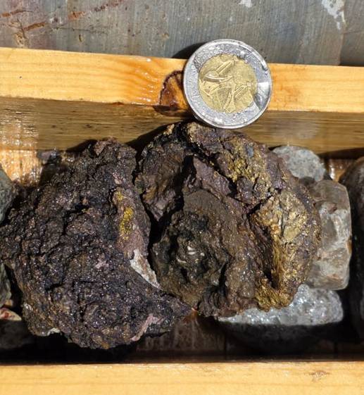
· 8 m at 0.58% Cu, 147 g/t Ag and 0.26 g/t Au from 63 m in drillhole BH 174.
o Inc. 1.6 m at 1.67% Cu, 695 g/t Ag and 0.40 g/t Au from 66 m.
o and inc. 0.2 m at 10.24% Cu, 5,390 g/t Ag and 2.80 g/t Au from 66m.
· 1 m at 0.72% Cu, 402 g/t Ag and 0.36 g/t Au from 34 m in drillhole BH 175.
· 5 m at 0.55% Cu, 4 g/t Ag and 0.05 g/t Au from 79.3 m in drillhole BH 175.
· 5.5 m at 0.55% Cu, 1 g/t Ag and 0.05 g/t Au from 70.5 m in drillhole BH 178.
· 10.2 m at 0.72% Cu, 5 g/t Ag and 0.05 g/t Au from 41 m in drillhole BH 160.
o Inc. 1 m at 2.46% Cu, 20 g/t Ag and 0.05 g/t Au from 48.8 m.
· 7.7 m at 0.51% Cu, 1 g/t Ag and 0.05 g/t Au from 22 m in drillhole BH 161.
Silver Structure
Of particular interest are the high grade copper and silver intercepts in drillholes 174 and 175, which occur within distinct massive sulphide lense material and intense quartz carbonate veining respectively and appear coincident and possibly related to the nearby semi-regional NNW fault, a potential control not previously encountered.
Drillhole BH 174 which returned 5.4 kg per tonne silver, 2.8 g/t gold and 10.2% copper over 0.2 m, was drilled directly into the NNW fault structure. The high-grade mineralisation is associated with massive sulphides at 66 m down hole, a new style of mineralisation (Figure 7) which will represent a new target going forward.
Further exploration is required to understand the higher silver mineralisation, but the results are very encouraging.
Sedimentary Copper
The drilling has also extended potentially economic Cu-Ag stratiform mineralisation further to the east in Zone 1 within the silicified carbonate and clastic sediments and further towards mineralised Zone 2.
Hole 160, which intercepted 10.2 m at 0.72% Cu, is one of several holes with more than 5 m of near-surface mineralisation. In terms of metal copper content and potential economic significance, it compares favourably with previously reported, thinner higher-grade intercepts, including BH 38 with 3 m at 1.09% Cu and 1.0 g/t Ag, and BH 119 with 3.5 m at 1.02% Cu and 6.43 g/t Ag.
Charlie Long, CEO of CMR, commented:
"This is an excellent result for the company and something new and unexpected. Initial geological interpretation indicates that the high-grade silver mineralisation is associated with a fault-controlled structure, in fact hole BH 174 sits directly on the fault. So we now have potential for a distinct silver target alongside the mainstay sedimentary copper target.
These very exciting silver results are another example of Agadir Melloul continuing to reveal mineralisation beyond what we initially expected. The 2.6 metre intercept grading 430 grams per tonne silver is particularly significant, especially the 20 centimetre interval grading 5 kilograms per tonne silver together with 10% copper and 2.8g/t gold.
Our initial interpretation is that this may represent a separate, fault-controlled high-grade silver structure rather than simply a higher-grade silver zone within the sedimentary copper system. It is still early however, and we need further work to determine its orientation, depth extension, continuity and scale. At the very least, it gives us a very interesting new exploration target and more high value rock.
Much of our drilling over the summer has necessarily concentrated on resource delineation. It is critical that we define areas of good mineralisation from areas that are unmineralized or below our cut-off. Afterall, when mining starts we need to know where to mine for copper and which areas to avoid.
We are now moving into a period where results from that work are coming back from the laboratory, with further results from the sediment-hosted copper mineralisation expected over the next two to three weeks.
Agadir Melloul continues to develop geologically and these latest results demonstrate that there is still considerably more to understand about the mineralised system. We look forward to providing further drill results in due course".
Drilling and assay programme
During the summer, drilling was focused predominantly on delineation and infill work designed to improve the geological definition of the sediment-hosted copper mineralisation and support the ongoing Mineral Resource Estimate.
A number of batches of drill samples are now progressing through the laboratory and assay results are beginning to be received. The Company currently expects the next batch of results, principally relating to sediment-hosted copper mineralisation, within approximately two to three weeks. Further updates will be provided as results become available and have been interpreted.
Work Completed
Standard diamond drilling procedures were used to complete the holes being reported herein. Holes were drilled using standard double tube HQ drilling and include collar and downhole survey as standard.
The number of drillholes totals 272 (244 diamond and 28 RC) for a combined 11,347 metres, of which, 244 diamond holes (8,200 m) have been completed following the joint venture agreement signing in May 2025. Depths range between 5 m to 98 m and an average of 42 m and are located in Zone 1 and Zone 2 of the project area, as shown in Figures 2 and 3.
2,137 samples have been submitted to Afrilab, Morrocco (accredited [subsidiary] by SGS) for standard four acid digest and multi-element ICP analysis. Following a summer period focused primarily on resource delineation drilling, assay results are now returning from the laboratory.
Table 1: Significant intercepts from reported holes using a trigger value of 0.2% Cu, minimum length of 1.5 m (including combined total intervals of internal waste up to 2 m in thickness) with a minimum composite grade of 0.5% Cu.
|
|
FROM |
TO |
Interval |
Cu% |
Au g/t |
Ag g/t |
|
BH 160 |
41.00 |
51.20 |
10.20 |
0.72 |
0.05 |
5 |
|
BH 161 |
22.00 |
29.70 |
7.70 |
0.51 |
0.05 |
1 |
|
BH 174 |
63.00 |
71.00 |
8.00 |
0.58 |
0.26 |
147 |
|
Inc. |
66.00 |
67.60 |
1.60 |
1.67 |
0.39 |
695 |
|
BH 175 |
79.30 |
84.30 |
5.00 |
0.55 |
0.05 |
5 |
|
Inc. |
79.30 |
81.30 |
2.00 |
0.81 |
0.03 |
3.5 |
|
BH 178 |
70.50 |
76.00 |
5.50 |
0.55 |
0.05 |
1 |
The mineralisation is believed to be approximately horizontal and as such, reported thickness are approximately 90 to 95% representative of the true thickness. No metal equivalent calculations are presented (Figures 6 and 7).
Geology and Geological Interpretation
The Agadir Melloul project is a sediment-hosted copper-silver deposit in the Western Anti-Atlas of central Morocco, targeting the early Cambrian and Infracambrian marine sedimentary Adoudounian unit. Mineralisation is mainly hosted in limestone, dolomite and conglomerate formations and is laterally extensive, shallow and gently dipping (Figure 4).
Mineralisation
The copper-bearing assembly is dominated by a mix of sulphide and carbonate minerals, specifically chalcopyrite, chalcocite, bornite, and malachite (Figures 6 and 7).
Competent Person's Statement and Technical Sign off
The technical information in this release which relates to CMR's Agadir Melloul project is based upon and fairly represents information and data presented and reviewed by Mr. James Hogg, MSc., Principal Geologist for Addison Mining Services, who is a Member of the Australian Institute of Geoscientists.
The results have also been reviewed by Mr. Lewis Harvey MSc, MAIG, Principal Geologist for Addison Mining Services (AMS).
Mr Harvey and Mr Hogg have sufficient experience relevant to the style of mineralisation, the type of deposit under consideration and the activity undertaken to qualify as Competent Persons as defined in the JORC Code 2012 edition of the Australasian Code for Reporting of Exploration Results, Mineral Resources and Ore Reserves, and Qualified Persons under the AIM rules.
Mr. Hogg (who has visited Agadir Melloul) and Mr. Harvey have reviewed and verified the technical information that forms the basis of and has been used in the preparation of this announcement, including all sampling and analytical data, and analytical techniques where applicable. Mr. Hogg and Mr. Harvey consent to the inclusion in this announcement of the matters based on the information, in the form and context in which it appears.
Forward-Looking Statement
This announcement contains forward-looking statements which involve a number of risks and uncertainties. These forward-looking statements are expressed in good faith and believed to have a reasonable basis.
These statements reflect current expectations, intentions or strategies regarding the future and assumptions based on currently available information. Should one or more of the risks or uncertainties materialise, or should underlying assumptions prove incorrect, actual results may vary from the expectations, intentions and strategies described in this announcement. No obligation is assumed to update forward-looking statements if these beliefs, opinions and estimates should change or to reflect other future developments.
For further information on the Company, please visit www.cmrplc.com or:
|
Critical Mineral Resources plc Charles Long, Chief Executive Officer |
|
|
Shard Capital LLP Corporate Adviser |
+44 (0) 207 186 9952 Erik Woolgar / Damon Heath |
Glossary of Technical Terms:
|
"%" |
percent |
|
"CEO" |
Chief Executive Officer |
|
"CMR" |
Critical Mineral Resources Plc |
|
"CMRS.L" |
Critical Mineral Resources Plc |
|
"CP" |
Competent Person |
|
"CRM" |
Certified reference material or standard |
|
"DTM" |
Digital Terrain Model. Computerised topographic model |
|
"HQ" |
Core Sample Diameter: 63.5 mm (2.5 inches) |
|
"inc" |
including |
|
"MAIG" |
Member of the Australian Institute of Geoscientists |
|
"MRE" |
Mineral Resource Estimate |
|
"NQ" |
Core Sample Diameter: 47.6 mm (1.87 inches) |
|
"Ag" |
Silver |
|
"AMS" |
Addison Mining Services |
|
"Au" |
Gold |
|
"Cu" |
Copper |
|
"ICP" |
Inductively coupled plasma. A high-temperature ionized gas source used to break down samples into atoms and ions for chemical analysis. |
|
"JORC (2012)" |
2012 edition of the JORC code |
|
"JORC" |
Australasian Code for Reporting of Exploration Results, Mineral Resources and Ore Reserves, as published by the Joint Ore Reserves Committee of The Australasian Institute of Mining and Metallurgy, Australian Institute of Geoscientists and Minerals Council of Australia |
|
"km" |
Kilometre |
|
"LSE" |
London Stock Exchange. |
|
"m" |
metre |
|
"QA/QC" |
Quality Assurance/Quality Control, |
|
"SGS" |
Société Générale de Surveillance SA (SGS) Laboratory Services |
Fig. 1 Locaton map
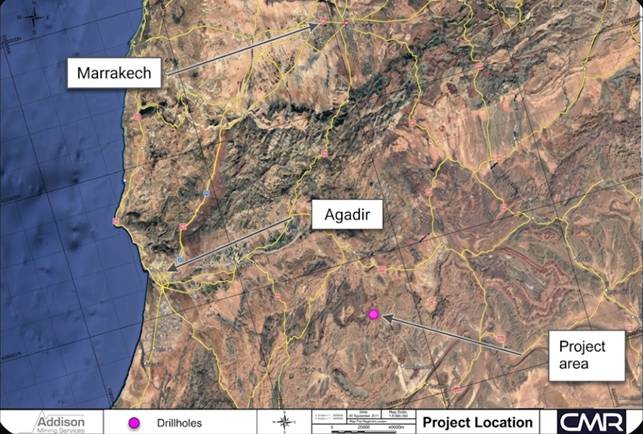
Fig. 2 Drill hole plan
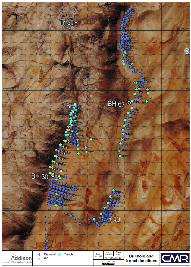
Fig. 3 Drill hole plan
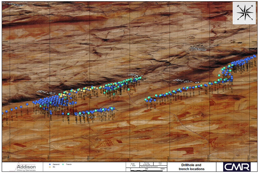
Fig. 4 Cross section 1
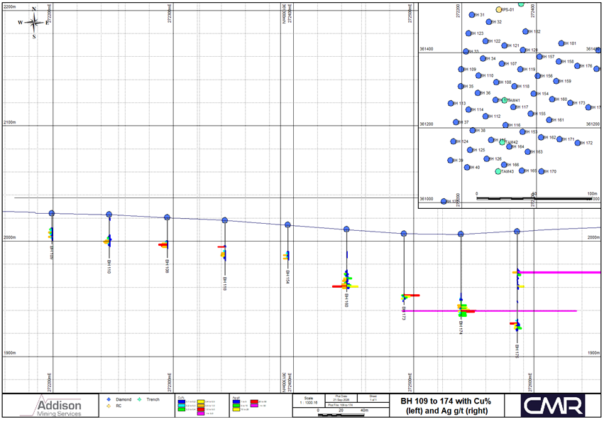
Fig. 5. Cross section 2
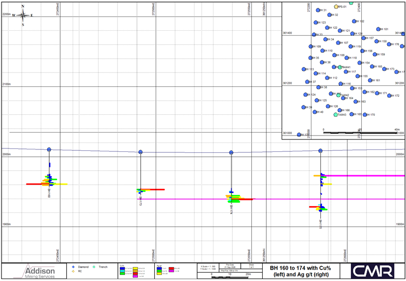
Fig. 6 Silver intercept in DDH 175
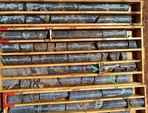
Fig. 7 High grade silver intercept in DDH 174 (massive sulphides)
Appendix 1: Table 1 (JORC 2012)
Section 1 Sampling Techniques and Data
(Criteria in this section apply to all succeeding sections)
|
Criteria |
JORC Code explanation |
AMS Commentary |
|
Sampling techniques |
· Nature and quality of sampling (e.g. cut channels, random chips, or specific specialised industry standard measurement tools appropriate to the minerals under investigation, such as down hole gamma sondes, or handheld XRF instruments, etc). These examples should not be taken as limiting the broad meaning of sampling. |
· Samples were generated using standard diamond drilling procedures. · Core was typically HQ. · The sampling methods are sufficient for the current stage of exploration. · No handheld XRF or downhole instruments were used. |
|
· Include reference to measures taken to ensure sample representivity and the appropriate calibration of any measurement tools or systems used |
· Sampling was supervised by a CMR geologist throughout. · Samples are considered representative of the deposit and are sufficient for the current stage of exploration. · The deposit is approximately horizontal, and holes are vertical, and as such, reported thickness are approximately 90 to 95% representative of the true thickness. · No additional measurement tools were used. |
|
|
· Aspects of the determination of mineralisation that are Material to the Public Report. |
· Samples were half core and sampling was constrained by similar geological characteristics where possible. · Samples were oven-dried and split. · Samples were analysed at Afrilab, Morrocco (an accredited subsidiary of SGS). · Standard four acid digest and multi-element ICP analysis. |
|
|
· In cases where 'industry standard' work has been done this would be relatively simple (e.g. 'reverse circulation drilling was used to obtain 1 m samples from which 3 kg was pulverised to produce a 30 g charge for fire assay'). In other cases more explanation may be required, such as where there is coarse gold that has inherent sampling problems. Unusual commodities or mineralisation types (e.g. submarine nodules) may warrant disclosure of detailed information. |
· Samples were generated using standard diamond drilling procedures. · Core was typically HQ. · Samples were half core and sampling was constrained by similar geological characteristics where possible. · Sample lengths are typically around 1 m. · Sample weights were around 2-3 kg. · Samples are dried, crushed and pulverised to produce a 30 / 50 g pulp for four acid digest and multi-element ICP analysis. |
|
|
Drilling techniques
|
· Drill type (e.g. core, reverse circulation, open-hole hammer, rotary air blast, auger, Bangka, sonic, etc) and details (e.g. core diameter, triple or standard tube, depth of diamond tails, face-sampling bit or other type, whether core is oriented and if so, by what method, etc). |
· Samples were generated using standard double tube diamond drilling. · Core was typically HQ. · Core is not oriented. |
|
Drill sample recovery
|
· Method of recording and assessing core and chip sample recoveries and results assessed. |
· Core was measured using a tape measure to assess recovery by the drillers. · Depth confirmed and compared to and from, from drillers' measurements. · Recovery data not included in current database. Database overhaul in progress which addresses recovery data. · Visual inspection of core from site visit shows recovery to be reasonable. |
|
· Measures taken to maximise sample recovery and ensure representative nature of the samples. |
· Measures taken to improve recovery include the use of added thickeners and polymers. |
|
|
· Whether a relationship exists between sample recovery and grade and whether sample bias may have occurred due to preferential loss/gain of fine/coarse material. |
· No recovery data is available for comparison and scattergram analysis at this time. · Further work is required to check against potential biases. |
|
|
Logging
|
· Whether core and chip samples have been geologically and geotechnically logged to a level of detail to support appropriate Mineral Resource estimation, mining studies and metallurgical studies. |
· Core was geologically logged in its entirety, covering lithology, grain size, and colour amongst others. · Recovery was noted, no detailed geotechnical logging is currently available. · Geological logging is sufficient to support any estimation studies. · Geotechnical logging review is pending. |
|
· Whether logging is qualitative or quantitative in nature. Core (or costean, channel, etc) photography. |
· Geological logging is qualitative. · Photography was completed on all the core boxes. |
|
|
· The total length and percentage of the relevant intersections logged. |
· All intersections were geologically logged and photographed. · Geotechnical logging review is pending. |
|
|
Sub-sampling techniques and sample preparation
|
· If core, whether cut or sawn and whether quarter, half or all core taken. |
· The hole is selectively sampled. · Core is cut in half by a core saw. · Half for analysis and half for reference. · Duplicate samples are quarter-core. |
|
· If non-core, whether riffled, tube sampled, rotary split, etc and whether sampled wet or dry. |
· Samples are core. · Samples are dry. |
|
|
· For all sample types, the nature, quality and appropriateness of the sample preparation technique. |
· Sample collection procedures, sample size, preparation and analysis are considered appropriate for the mineralogy, deposit type and the stage of the exploration. · Samples are of sufficient quality for the exploration stage of the project. |
|
|
· Quality control procedures adopted for all sub-sampling stages to maximise representivity of samples. |
· Samples were visually checked by the CMR geologist to ensure samples were representative of the core. · Samples have been reviewed by AMS and the CP on the site visit to check for representativity. |
|
|
· Measures taken to ensure that the sampling is representative of the in situ material collected, including for instance results for field duplicate/second-half sampling. |
· Samples are systemically sent from the right hand side of the core, ensuring representativity along the core axis where possible. · Field duplicates are generated using reference samples from the primary sample and submitted to the laboratory to monitor for repeatability. |
|
|
· Whether sample sizes are appropriate to the grain size of the material being sampled. |
· Preliminary review from the CP site visit suggests that the sample sizes are appropriate to the grain size. · No detailed work has been completed in this area. |
|
|
Quality of assay data and laboratory tests
|
· The nature, quality and appropriateness of the assaying and laboratory procedures used and whether the technique is considered partial or total. |
· Samples were analysed at Afrilab, Morrocco (an accredited subsidiary of SGS). · Afrilab are accredited with ISO 9001:2015 certification. · Standard four acid digest and multi-element ICP analysis. · Sample analytical techniques are considered in line with industry standards for this style of mineralisation. · Given the expected grades, lithology and deposit type, the laboratory procedures are considered appropriate for this level of work.
|
|
· For geophysical tools, spectrometers, handheld XRF instruments, etc, the parameters used in determining the analysis including instrument make and model, reading times, calibrations factors applied and their derivation, etc. |
· No geophysical tools, spectrometers or handheld XRF instruments were used in the exploration work. |
|
|
· Nature of quality control procedures adopted (e.g. standards, blanks, duplicates, external laboratory checks) and whether acceptable levels of accuracy (i.e. lack of bias) and precision have been established.
|
· CMR routinely insert blanks and duplicates into the sample stream. · Currently no CRMs are inserted. Procedures are being updated to include routine insertion. · QC inserted at a rate of approximately 1:10. · As no CRM data was available, AMS and the CP completed a preliminary review of the internal laboratory QC and found no issues. · The quality and nature of assay data and laboratory tests are acceptable for the exploration work for this deposit. However, CRM insertion is required. · Scattergrams were completed on duplicate samples, and no significant issues were observed. · The nature and quantity of QC data for the sampling, procedures employed, level of accuracy and precision are considered adequate for the number of primary samples and level of exploration. CMR plan a programme of CRM insertion for continued exploration. |
|
|
Verification of sampling and assaying
|
· The verification of significant intersections by either independent or alternative company personnel. |
· The results were independently verified and reviewed by Mr. J. Hogg, MSc. MAIG and Mr. L Harvey, MSc. MAIG Principal Geologists for Addison Mining Services (AMS). · Mr. Hogg and Mr. Harvey have sufficient experience relevant to the style of mineralisation, the type of deposit under consideration and the activity undertaken to qualify as a Competent Person as defined in the JORC Code 2012 edition of the Australasian Code for Reporting of Exploration Results, Mineral Resources and Ore Reserves. · Mr. Hogg and Mr. Harvey have reviewed and verified the technical information that forms the basis of and has been used in the preparation of this announcement, including all sampling and analytical data, and analytical techniques where applicable. · Mr. Hogg and Mr. Harvey consent to the inclusion in this announcement of the matters based on the information, in the form and context in which it appears. |
|
· The use of twinned holes. |
· No twin holes have been completed at this time. |
|
|
· Documentation of primary data, data entry procedures, data verification, data storage (physical and electronic) protocols. |
· Sample coordinates and assay data was provided to AMS in Excel data. · Data was imported to Micromine 3D geological modelling software by AMS. · The CMR assay database was by cross reference against original laboratory assay certificates by AMS and the CP. |
|
|
· Discuss any adjustments to assay data. |
· No adjustments to the analytical data were necessary. · Raw analytical data remained unchanged. |
|
|
Location of data points
|
· Accuracy and quality of surveys used to locate drill holes (collar and down-hole surveys), trenches, mine workings and other locations used in Mineral Resource estimation. |
· Drillholes were surveyed using a DGPS. · Downhole survey completed using Reflex tool. · Accuracy is sufficient for the stage of exploration. |
|
· Specification of the grid system used. |
· Data was captured and located using Lambert Maroc - Merchich, Zone II (Agadir), EPSG:26192. · Elevations are reported in metres above sea level. |
|
|
· Quality and adequacy of topographic control. |
· An accurate topographic DTM is pending. |
|
|
Data spacing and distribution
|
· Data spacing for reporting of Exploration Results. |
· Sample spacing in the licence varies from 100 x 50 to 50 x 50 m. · Data spacing is sufficient for the stage of exploration. |
|
· Whether the data spacing and distribution is sufficient to establish the degree of geological and grade continuity appropriate for the Mineral Resource and Ore Reserve estimation procedure(s) and classifications applied. |
· The data spacing and distribution are likely sufficient to establish the degree of geological and grade continuity appropriate for future Mineral Resource Estimations. · No MRE is being reported herein. |
|
|
· Whether sample compositing has been applied. |
· No sample compositing, apart from that of reporting the exploration results as significant intercepts. |
|
|
Orientation of data in relation to geological structure
|
· Whether the orientation of sampling achieves unbiased sampling of possible structures and the extent to which this is known, considering the deposit type. |
· Deposit is roughly flat lying and holes are vertical, increasing the representivity of target thicknesses. · No bias is currently perceived. Further work required. |
|
· If the relationship between the drilling orientation and the orientation of key mineralised structures is considered to have introduced a sampling bias, this should be assessed and reported if material. |
· There is no relationship bias perceived between drilling orientation and the orientation of mineralised structures. · Deposit is roughly flat lying and holes are vertical, increasing the representivity of target thicknesses. · Further work required to prove any relationship. |
|
|
Sample security
|
· The measures taken to ensure sample security. |
· Samples were transported from the site to the laboratory in secure polyweave bags by CMR staff. · CMR and Afrilab are responsible for the chain of custody. · The samples arrived in good condition at Afrilab. |
|
Audits or reviews
|
· The results of any audits or reviews of sampling techniques and data. |
· Desk study review and audit by Principal Consultants Mr. James Hogg and Mr Lewis Harvey determined sampling methods are suitable for the current project stage. · Mr James Hogg conducted a site visit during the drilling in August 2026. |
Section 2 Reporting of Exploration Results
(Criteria listed in the preceding section also apply to this section)
|
Criteria |
JORC Code explanation |
AMS Comments |
||||||||||||||||||||||||
|
Mineral tenement and land tenure status
|
· Type, reference name/number, location and ownership including agreements or material issues with third parties such as joint ventures, partnerships, overriding royalties, native title interests, historical sites, wilderness or national park and environmental settings.
|
· CMR is earning into a 60% interest in six permits, covering approximately 65 km2 of Central Morrocco, near the village of Agadir Melloul. · Of the six licenses, CMR has a 50% contractual interest in three permits and 20% in the remaining three. · It is located in the Western Anti-Atlas of Central Morocco, an area known to be prospective for Cu, Au and Ag mineralisation and is located 250 km southwest of Marrakech, and 240 km from the deep seaport and industrial zone of Agadir. · There are no sites of special scientific interest, native title, national parks or historical importance within the that BWAR are aware of. · There is a national forest reserve to the north and outside of the licence area which is unlikely to affect exploration or mining activities. |
||||||||||||||||||||||||
|
· The security of the tenure held at the time of reporting along with any known impediments to obtaining a licence to operate in the area. |
· All tenements are in good standing. · AMS are unaware of any impediments that may affect the licences. · There are no encumbrances that may affect the licence that AMS are aware of. |
|||||||||||||||||||||||||
|
Exploration done by other parties
|
· Acknowledgment and appraisal of exploration by other parties. |
· There has been limited historical exploration carried. · Data is yet to be located. |
||||||||||||||||||||||||
|
Geology
|
· Deposit type, geological setting and style of mineralisation |
· The Agadir Melloul project is a sediment-hosted copper-silver deposit in the Western Anti-Atlas of central Morocco, targeting the marine sedimentary Adoudounian unit. · Mineralisation is mainly hosted in limestone, dolomite and conglomerate formations and is laterally extensive, shallow and gently dipping. · The copper-bearing assembly is dominated by a mix of sulphide and carbonate minerals, specifically chalcopyrite, chalcocite, bornite, and malachite. |
||||||||||||||||||||||||
|
Drill hole Info.
|
· A summary of all information material to the understanding of the exploration results including a tabulation of the following information for all Material drill holes: o easting and northing of the drill hole collar o elevation or RL (Reduced Level - elevation above sea level in metres) of the drill hole collar o dip and azimuth of the hole o down hole length and interception depth o hole length. |
· Collar coordinates and details are presented in the table below.
|
||||||||||||||||||||||||
|
· If the exclusion of this information is justified on the basis that the information is not Material and this exclusion does not detract from the understanding of the report, the Competent Person should clearly explain why this is the case. |
· No information has been omitted. · All material information has been described in Table 1. |
|||||||||||||||||||||||||
|
Data aggregation methods
|
· In reporting Exploration Results, weighting averaging techniques, maximum and/or minimum grade truncations (e.g. cutting of high grades) and cut-off grades are usually Material and should be stated. |
· In terms of Cu, reporting of significant intercepts from reported holes using a trigger value of 0.2% Cu, minimum length of 1.5 m (including combined total intervals of internal waste up to 2 m in thickness) with a minimum composite grade of 0.5% Cu. · For Au, a trigger value of 0.1% Au, minimum length of 2 m (including internal waste up to 1 m) with a minimum composite grade of 0.2% Au. |
||||||||||||||||||||||||
|
· Where aggregate intercepts incorporate short lengths of high-grade results and longer lengths of low grade results, the procedure used for such aggregation should be stated and some typical examples of such aggregations should be shown in detail. |
· N/A. |
|||||||||||||||||||||||||
|
· The assumptions used for any reporting of metal equivalent values should be clearly stated. |
· No metal equivalent values were used. |
|||||||||||||||||||||||||
|
Relationship between mineralisation widths and intercept lengths
|
· These relationships are particularly important in the reporting of Exploration Results. |
· The deposit is approximately horizontal, and holes are vertical, and as such, reported thickness are approximately 90 to 95% representative of the true thickness. |
||||||||||||||||||||||||
|
· If the geometry of the mineralisation with respect to the drill hole angle is known, its nature should be reported. |
· The drillholes are vertical and the mineralisation is approximately horizontal. · The appeared width is likely a true representation of the true thickness. |
|||||||||||||||||||||||||
|
· If it is not known and only the down hole lengths are reported, there should be a clear statement to this effect (e.g. 'down hole length, true width not known'). |
· Holes are vertical and the mineralisation is horizontal, as such, the downhole width and interval widths are likely a reasonable reflection of the true width. · Further work is required to confirm the relationship. |
|||||||||||||||||||||||||
|
Diagrams
|
· Appropriate maps and sections (with scales) and tabulations of intercepts should be included for any significant discovery being reported. These should include, but not be limited to a plan view of drill hole collar locations and appropriate sectional views. |
· Appropriate scaled diagrams are attached to the announcement. |
||||||||||||||||||||||||
|
Balanced reporting
|
· Where comprehensive reporting of all Exploration Results is not practicable, representative reporting of both low and high grades and/or widths should be practiced to avoid misleading reporting of Exploration Results. |
· The current database and dataroom are in the process of being re-built and as such, as much of the available exploration data for the Project has been reported at this time. · Further balanced reporting will be included in future announcements. · AMS consider the reporting of the results to be in line with industry best standards and representative of the deposit. |
||||||||||||||||||||||||
|
Other substantive exploration data
|
· Other exploration data, if meaningful and material, should be reported including (but not limited to): geological observations; geophysical survey results; geochemical survey results; bulk samples - size and method of treatment; metallurgical test results; bulk density, groundwater, geotechnical and rock characteristics; potential deleterious or contaminating substances. |
· Significant geological mapping works have been completed. · No geophysical works have been completed. · No thin section microscopy has been completed to date. · No bulk density work completed to date. |
||||||||||||||||||||||||
|
Further work
|
· The nature and scale of planned further work (e.g. tests for lateral extensions or depth extensions or large-scale step-out drilling). |
· Further work includes additional infill drilling and sampling in prospective areas to delineate lateral extents. · Further bulk density, planned to commence in Q4 2026. · Metallurgical and recovery testwork. |
||||||||||||||||||||||||
|
· Diagrams clearly highlighting the areas of possible extensions, including the main geological interpretations and future drilling areas, provided this information is not commercially sensitive |
· Further work programmes are commercially sensitive and as such, are not presented at this time. · Exploration is planned over the whole licence area. |
Appendix 2: Drilling parameters
Drilling parameters for the reported diamond drillholes. *Lambert Maroc - Merchich, Zone II (Agadir), EPSG:26192
|
Hole ID |
Easting* |
Northing* |
RL |
DIP |
Azi |
Depth |
|
BH 158 |
272460.00 |
361376.00 |
2008.79 |
-90.00 |
0.00 |
43.50 |
|
BH 159 |
272453.00 |
361324.00 |
2009.53 |
-90.00 |
0.00 |
44.50 |
|
BH 160 |
272442.00 |
361276.00 |
2010.13 |
-90.00 |
0.00 |
54.30 |
|
BH 161 |
272434.00 |
361220.00 |
2014.35 |
-90.00 |
0.00 |
40.00 |
|
BH 162 |
272413.00 |
361174.00 |
2016.00 |
-90.00 |
0.00 |
53.00 |
|
BH 163 |
272377.00 |
361135.00 |
2018.12 |
-90.00 |
0.00 |
62.00 |
|
BH 164 |
272328.00 |
361149.00 |
2020.63 |
-90.00 |
0.00 |
53.60 |
|
BH 165 |
272361.00 |
361085.00 |
2020.30 |
-90.00 |
0.00 |
53.00 |
|
BH 166 |
272314.00 |
361101.00 |
2024.18 |
-90.00 |
0.00 |
50.00 |
|
BH 167 |
272142.00 |
360583.00 |
2036.36 |
-90.00 |
0.00 |
95.00 |
|
BH 168 |
272146.00 |
360485.00 |
2035.68 |
-90.00 |
0.00 |
98.00 |
|
BH 169 |
272145.00 |
360380.00 |
2032.58 |
-90.00 |
0.00 |
85.00 |
|
BH 170 |
272414.00 |
361083.00 |
2017.29 |
-90.00 |
0.00 |
71.00 |
|
BH 171 |
272462.00 |
361169.00 |
2014.96 |
-90.00 |
0.00 |
53.00 |
|
BH 172 |
272510.00 |
361159.00 |
2014.44 |
-90.00 |
0.00 |
65.00 |
|
BH 173 |
272491.00 |
361266.00 |
2006.59 |
-90.00 |
0.00 |
62.00 |
|
BH 174 |
272539.00 |
361254.00 |
2005.98 |
-90.00 |
0.00 |
74.00 |
|
BH 175 |
272587.00 |
361245.00 |
2008.31 |
-90.00 |
0.00 |
97.00 |
|
BH 176 |
272509.00 |
361364.00 |
2000.26 |
-90.00 |
0.00 |
56.00 |
|
BH 177 |
272561.00 |
361357.00 |
1999.51 |
-90.00 |
0.00 |
62.00 |
|
BH 178 |
272608.00 |
361348.00 |
2005.35 |
-90.00 |
0.00 |
80.00 |
RNS may use your IP address to confirm compliance with the terms and conditions, to analyse how you engage with the information contained in this communication, and to share such analysis on an anonymised basis with others as part of our commercial services. For further information about how RNS and the London Stock Exchange use the personal data you provide us, please see our Privacy Policy.

Latest directors dealings
- 3 minutes ago Gresham House Energy Storage Fund
- 13 minutes ago Jardine Matheson Holdings Ltd (Singapore Reg)
- 26 minutes ago Jardine Matheson Holdings Ltd (Singapore Reg)
- 50 minutes ago Cranswick
- 1 hour ago IntegraFin Holding