This announcement contains inside information for the purposes of Article 7 of the UK version of Regulation (EU) No 596/2014 which is part of UK law by virtue of the European Union (Withdrawal) Act 2018, as amended ("MAR"). Upon the publication of this announcement via a Regulatory Information Service, this inside information is now considered to be in the public domain.
30 September 2026
AIM: AAU
ASX: AA2
Dokwe Project Feasibility Programme Update
Ariana Resources plc (AIM: AAU, ASX: AA2, “Ariana” or the “Company”), the mineral exploration and development company advancing the 100% owned, 1.6 Moz Dokwe Gold Project (“Dokwe” or “the Project”) in Zimbabwe, is pleased to announce an update on its Feasibility Study Programme for the Project.
Highlights:
-
Independent Mineral Resource Estimate underway, incorporating c.11,000m of RC and diamond drilling completed recently.
-
2,200m of water bore drilling underway in an area hosting a potential aquifer to the north of Dokwe, in order to define a source for processing water.
-
Metallurgical testwork underway with Xinhai and IMO, in China and Australia respectively.
-
Geotechnical drilling completed at Dokwe Central, which provides new data for the planning of the expected Dokwe Central open-pit.
-
2,300m of RC drilling due to commence for infrastructure area sterilisation and associated exploration.
-
Aeromagnetic and LiDAR survey to commence, which will enable better exploration planning and targeting ahead of future drilling programmes.
Dr. Kerim Sener, Managing Director, commented:
“We are making excellent headway with the Feasibility Study programme for the Dokwe Gold Project in Zimbabwe on several very active fronts. With the recent completion of exploration and resource drilling programmes totalling c.11,000m, we are now advancing our work towards an Independent Mineral Resource Estimate with consultants, AMC Consultants Limited in the UK. This will become the final MRE for the purposes of the Feasibility Study.
“Furthermore, we are advancing towards a revised Ore Reserve statement which we expect towards the end of this year. This is expected to include Dokwe Central in Reserve for the first time, following the completion of recent geotechnical and metallurgical drilling at that location. Metallurgical testwork with Xinhai in China is underway, and sub-samples have now also been sent from China to IMO in Perth, Australia, for additional testwork for the feasibility study.
“Various other project developments are underway, notably the commencement of our c.2,200m water drilling programme to ensure we will have sufficient water supply for the processing plant. Knight Piesold are underway with a tailings management and layout design options study, which will determine a final layout and tailings option for the feasibility study.
“Beyond this, we are preparing to commence several new exploration and development activities across the project. Notably, we are due to commence from early October a sterilisation and exploration drilling programme in the expected mine infrastructure area. In addition, we will be undertaking a detailed aeromagnetic and LiDAR survey over the entire project area, in order to assist with future exploration drilling planning. Ultimately, we want to test systematically the remaining 10km of identified prospective shear zones that are untested by drilling, which to date has only examined 3km of strike.
“We also note the significant local support for the development of the project and look forward to continuing our work with the local community to make a meaningful and positive social impact over the years ahead.”
Dokwe Operations Update
Various projects are moving at pace as Ariana continues to move Dokwe forward towards development. The results from these projects will feed into the Dokwe Feasibility Study (“DFS”).
Mineral Resource Estimate Update
AMC Consultants (UK) Limited have been commissioned to undertake an independent Mineral Resource Estimate as required by the JORC Code (2012) for the Feasibility Study. The assay results from the metallurgical drilling will be incorporated, along with the results from the extensional drilling to the northeast of Dokwe North, and the southern extension to mineralisation intercepted in the drilling at Dokwe Central. For further information on the drill results, please see the AIM announcements on 10 September 2026 and 14 May 2026.
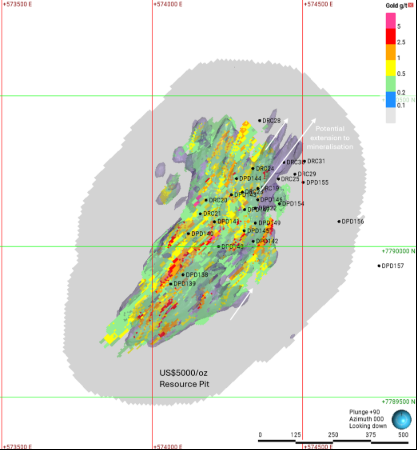
Figure 1: 2026 (May) Dokwe North block model displayed at a 0.2g/t Au cut-off, with potential mineralisation extensions (purple isoshells and white arrows) resulting from the 2026 drilling programmes. The pit shown is the US$5,000/oz Au optimised resource pit used to constrain the May 2026 MRE.
Water Bore Exploration Drilling Underway
Wellfield Geosciences have recently completed a desk-top study, a hydrological census, and a geophysical programme to identify target areas for potential mine water sources. Twelve priority holes are planned for 2,155m, and drilling is underway. The area of interest lies to the north of Dokwe, where a sequence of Karoo basalts and underlying sandstones provide a suitable setting for a series of aquifers. The Forest Sandstone is the target aquifer horizon, which is known for its quality and quantity of supply elsewhere in the Bulawayo region.
Three holes have been completed to date, with strong flows of good quality water encountered in the third hole in particular, which is located approximately 10km north of Dokwe (Figures 2 and 3).
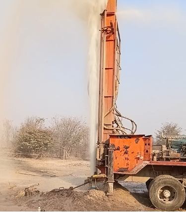
Figure 2: Water bore drilling, showing water under pressure escaping from the aquifer.
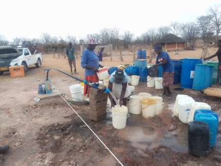
Figure 3: Nearby community accessing water while one of the recent holes is undergoing pump testing.
Metallurgical Test Work Underway
Eight tonnes of metallurgical samples arrived at Xinhai’s laboratory in Yantai, China (Figure 4), where 28 composites have been prepared under the auspices of Ariana’s consultants, Independent Metallurgical Operations Pty. Ltd. in Perth, Australia. Three bulk composites will be tested in Yantai, with the remaining ‘mine schedule’ composites and variability composites to be shipped to Perth, Western Australia, where they will be analysed further. Ariana Board members have visited both testing sites and are satisfied with the plans and procedures that both laboratories will be operating under.
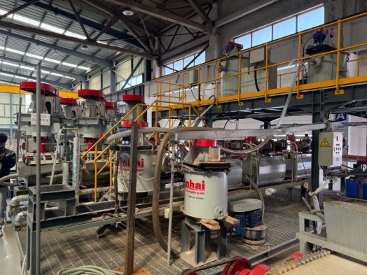
Figure 4: Part of the Xinhai testwork facilities in Yantai, China, where the Dokwe metallurgical samples will undergo bulk metallurgical testing.
Geotechnical drilling completed at Dokwe Central
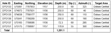
Six geotechnical holes were drilled at Dokwe Central for a total of 1,251m (Figures 5 and 6; Table 1). The cores were logged and sampled by OHMS representatives on site, and selected samples have arrived at the geotechnical laboratory for testing in South Africa. OHMS are currently working on a report, which will inform the pit design.
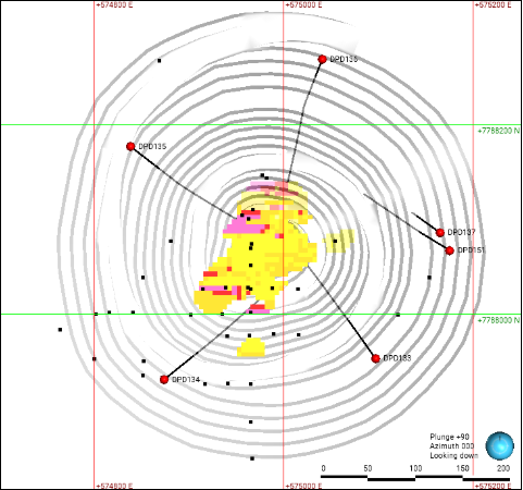
Figure 5: Plan map of geotechnical drilling completed at Dokwe Central in 2026 (red collars and black drill traces). Previous drill collars, 2026 Resource model (above 0.5g/t Au) and 2026 designed pit are shown for reference.
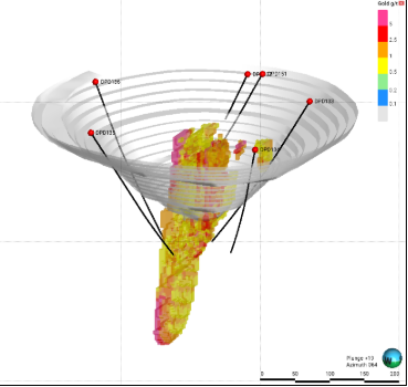
Figure 6: Oblique view (looking east) of the geotechnical drilling at Dokwe Central, with 2026 resource model and 2026 designed pit shell for reference.
Table 1: All 2026 oriented geotechnical diamond drill holes drilled to date, totalling 1,251m. Coordinates are UTM Zone 35S WGS84.
|
Hole ID
|
Easting
|
Northing
|
Elevation (m)
|
Depth (m)
|
Dip (o)
|
Azimuth (o)
|
Target Area
|
|
DPD133
|
575097
|
7787953
|
1157
|
250.0
|
60
|
325
|
Dokwe Central
|
|
DPD134
|
574873
|
7787931
|
1156
|
250.0
|
60
|
40
|
Dokwe Central
|
|
DPD135
|
574838
|
7788177
|
1156
|
250.0
|
60
|
110
|
Dokwe Central
|
|
DPD136
|
575041
|
7788269
|
1156
|
250.0
|
60
|
190
|
Dokwe Central
|
|
DPD137
|
575165
|
7788086
|
1156
|
72.3
|
60
|
295
|
Dokwe Central
|
|
DPD151
|
575175
|
7788067
|
1157
|
178.9
|
55
|
300
|
Dokwe Central
|
|
Total
|
|
|
|
1,251.1
|
|
|
|
Layout Design Options Study Proceeding
Knight Piesold are continuing to evaluate the layout design options for the optimum positioning of waste rock dumps and the tailings storage facility at Dokwe. Various scenarios have been assessed across a range of tailings types, ranging from conventional slurry to filtered, along with any benefits of combining the tailings and the waste rock. Key considerations include the volumes, footprint and haulage distances. A more detailed site investigation study is being formulated and will be acted upon once the design layout has been confirmed. The current site layout plan used for the pre-feasibility study is shown in Figure 7.
Sterilisation drilling planned for Q4 2026
In 2021, twenty-five vertical sterilisation holes were drilled to the east of the proposed Dokwe North pit, to a set depth of 70m (Figure 7). Within that depth range, the holes identified a dolerite sill that flanks the SE of the deposit, and an overlaying package of sedimentary rocks that are interpreted to continue southwards to the Dokwe Central Shear Zone. With the recent expansion of the potential resource envelope, and the revised mining and processing rates, the area covered by that earlier programme has been determined as not large enough for the proposed infrastructure. As a consequence, twenty-three new holes have been planned to cover the extended area. The first part of the programme comprises 23 holes for 2,300m of RC drilling (Figure 7).
A second phase of drilling will test for the contact between the volcanic and the sedimentary rocks, and 14 holes for 1,400m are planned (Figure 7). Understanding the precise location of the contact will aid a further upcoming exploration drilling programme beyond this second phase.
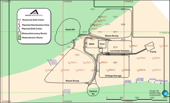
Figure 7: Proposed sterilisation drill holes (red collars and traces) where the mine site infrastructure is proposed to be sited (shown in black outlines). Previous vertical sterilisation drilling is shown for reference (black collars). The contact between volcanic and sedimentary rocks will also be tested (blue collars and traces), the location of which will be important for upcoming exploration.
Project area exploration programme planned
The three confirmed locations for gold mineralisation within the Dokwe Project area, Dokwe North, Dokwe Central and Siduli, are situated within three different structural corridors that are defined by the juxtaposition of various lithostratigraphic domains (Figure 8). The total length of the structural corridors within the project area is ~13km, and yet, despite hosting over 1.6Moz of gold, only 3km strike length of the 13km has been drilled to date (Figure 8).
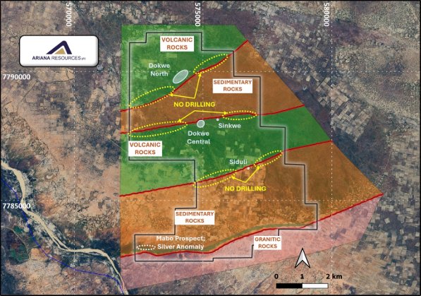
Figure 8: Map of the project area (black outline) and mining lease application (red outline) showing the geological interpretation of domains of sedimentary and volcanic rocks juxtaposed against each other. These ‘sutures’ are the focal point for the shear zones that host gold mineralisation. Only 3km of the 13km of shear zones within the claims area have been drilled to date.
The spatial relationship between Archaean lode gold deposits and regional shear zones is well known. Deposits typically formed where the shear zones were disrupted by intrusions, jogs or fold structures. The highest potential for the discovery of additional mineralisation within the project area occurs along these three shear zones. Future exploration will focus on areas that show localised offsets and disruptions, which are interpreted from current aeromagnetic images. A more detailed aeromagnetic programme coupled with a LiDAR survey is expected to commence shortly, in order to assist with drill target definition and planning.
The Dokwe North Structural Corridor (DNSC)
The Dokwe North Structural Corridor strikes for 4.5km within the project area. The corridor hosts the 1.5Moz Dokwe North gold deposit (Table 2). At least 2.5km of this strike length has never been drilled (Figure 9).
The DNSC was a focal point for a series of highly magnetic dykes (post-gold mineralisation), two of which are encountered on the flanks of the deposit. Dykes such as these are a common feature in some of the world’s best gold-endowed Archaean greenstone belts, such as the Yilgarn in Western Australia, and the Abitibi in Ontario, Canada. Their strong magnetism tends to swamp the more subtle magnetic signals of the Archaean rocks, making lithological and structural interpretations of the Archaean geology more challenging.
The approach for the DNSC will be to drill a series of fences across it, for which a plan for an RC drilling programme is underway; this plan will be further revised once new geophysical data is obtained from this zone. Ariana has a good understanding of the alteration and mineralisation characteristics within the DNSC to guide exploration. A similar approach will be taken along the other shear zones.
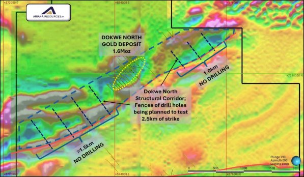
Figure 9: Aeromagnetic map highlighting the Dokwe North structural corridor and the areas with no drilling. Fence lines such as those shown will form the basis of Ariana’s exploration drilling.
Table 2: Mineral Resource Estimate for the Dokwe Gold Project
|
Deposit
|
Classification
|
Tonnage
(kt)
|
Grade
(g/t Au)
|
Contained Gold
(oz)
|
|
Dokwe North
|
Measured
|
21,055
|
0.92
|
621,500
|
|
Indicated
|
27,224
|
0.71
|
617,400
|
|
Inferred
|
11,963
|
0.67
|
258,500
|
|
Total
|
60,242
|
0.77
|
1,497,400
|
|
Dokwe Central
|
Indicated
|
2,107
|
1.39
|
94,300
|
|
Inferred
|
117
|
1.66
|
6,200
|
|
Total
|
2,225
|
1.41
|
100,600
|
|
Total
|
Measured
|
21,055
|
0.92
|
621,500
|
|
Indicated
|
29,331
|
0.75
|
711,700
|
|
Inferred
|
12,080
|
0.68
|
264,700
|
|
Total
|
62,467
|
0.80
|
1,598,000
|
Notes: The Dokwe Mineral Resource Estimate (as announced 26 May 2026) is reported within a Dokwe North pit-shell optimised at US$5,000/oz Au. The Mineral Resource Estimate is reported in accordance with the JORC (2012) Code, using a cut-off grade of 0.2g/t Au. Errors may be present due to rounding. The Dokwe Mineral Resource Estimate is inclusive of Reserves.
Compliance Statements
The information in this announcement relating to Mineral Resources and Ore Reserves has been reported by the Company in accordance with the 2012 Edition of the ‘Australasian Code for Reporting of Exploration results, Mineral Resources and Ore Reserves’ (JORC Code) previously (refer to the Company’s ASX release titled “Update to Optimised Dokwe Gold Project PFS Announcement released to the ASX market platform on 28 May 2026 and is available on the Company website at http://www.arianaresources.com/) (Previous Market Announcement).
The Company confirms that it is not aware of any new information or data that materially affects the information included in the Previous Market Announcement and, in the case of estimates of Mineral Resources and Ore Reserves, that all material assumptions and technical parameters underpinning the estimates in the Previous Market Announcement continue to apply and have not materially changed.
Competent Persons Statement
The information in this announcement that relates to Exploration Results is based on information compiled by Dr. Kerim Sener BSc (Hons), MSc, PhD, Managing Director of Ariana Resources plc. Dr. Sener is a Fellow of The Geological Society of London and a Member of The Institute of Materials, Minerals and Mining and has sufficient experience relevant to the styles of mineralisation and type of deposit under consideration and to the activity that has been undertaken to qualify as a Competent Person as defined by the 2012 edition of the Australasian Code for the Reporting of Exploration Results, Mineral Resources and Ore Reserves (JORC Code) and under the AIM Rules - Note for Mining and Oil & Gas Companies. Dr. Sener consents to the inclusion in the report of the matters based on his information in the form and context in which it appears.
The information in this announcement relating to the Mineral Resource Estimate at the Dokwe Gold Project is based on, and fairly represents, information and supporting documentation prepared by Ms. Ruth Woodcock, Exploration Group Leader, Ariana Resources plc. Ms. Woodcock is a member of Recognised Professional Organisations as defined by JORC 2012: a Chartered Geologist (CGeol, Geological Society of London) and European Geologist (EurGeol, European Federation of Geologists) and has sufficient experience which is relevant to the style of mineralisation and type of deposit under consideration and to the activity upon which she is reporting as a Competent Person as defined in the 2012 Edition of “The Australasian Code for Reporting of Exploration Results, Mineral Resources and Ore Reserves.” Ms. Woodcock consents to the inclusion in this report of the matters based on the information compiled by her, in the form and context in which it appears.
The Company confirms that the form and context in which the Competent Persons’ findings are presented have not been materially modified from the previous announcements.
Forward-looking statements and disclaimer
This announcement contains certain "forward-looking statements". Forward-looking statements can generally be identified by the use of forward looking words such as "forecast", "likely", "believe", "future", "project", "opinion", "guidance", "should", "could", "target", "propose", "to be", "foresee", "aim", "may", "will", "expect", "intend", "plan", "estimate", "anticipate", "continue", “indicative” and "guidance", and other similar words and expressions, which may include, without limitation, statements regarding plans, strategies and objectives of management, anticipated production dates, expected costs or production outputs for the Company, based on (among other things) its estimates of future production of the Projects.
To the extent that this document contains forward-looking information (including forward-looking statements, opinions or estimates), the forward-looking information is subject to a number of risk factors, including those generally associated with the gold exploration, mining and production businesses. Any such forward-looking statement also inherently involves known and unknown risks, uncertainties and other factors that may cause actual results, performance and achievements to be materially greater or less than estimated. These factors may include, but are not limited to, changes in commodity prices, foreign exchange fluctuations, general economic and share market conditions, increased costs and demand for production inputs, the speculative nature of exploration and project development (including the risks of obtaining necessary licenses and permits and diminishing quantities or grades of reserves), changes to the regulatory framework within which the Company operates or may in the future operate, environmental conditions including extreme weather conditions, geological and geotechnical events, and environmental issues, and the recruitment and retention of key personnel.
- ENDS -
The Board of Ariana Resources plc has approved this announcement and authorised its release.
For further information on the Company, please visit the website or please contact the following:
Contacts:
|
Ariana Resources plc
Michael Atkins, Chairman
Dr Kerim Sener, Managing Director
|
|
info@arianaresources.com
|
|
|
|
|
|
Beaumont Cornish Limited
(Nominated Adviser)
Roland Cornish / Felicity Geidt
|
|
Tel: +44 (0) 20 7628 3396
|
|
|
|
|
|
Zeus Capital (Joint Broker)
Harry Ansell / Katy Mitchell
Fortified Securities (Joint Broker)
Guy Wheatley
Yellow Jersey PR Limited (UK Financial PR)
Dom Barretto / Shivantha Thambirajah
M&C Partners (Aus Financial PR)
Christina Granger / Ben Henri
Shaw and Partners Limited
(Lead Manager – ASX)
Damien Gullone
|
|
Tel: +44 (0) 203 829 5000
Tel: +44 (0) 203 411 7773
Tel: +44 (0) 7983 521 488
arianaresources@yellowjerseypr.com
Tel: +61 438 227 286
christina.granger@mcpartners.com.au
Tel: +61 (0)2 9238 1268
|
Beaumont Cornish Limited (“Beaumont Cornish”) is the Company’s Nominated Adviser and is authorised and regulated by the FCA. Beaumont Cornish’s responsibilities as the Company’s Nominated Adviser, including a responsibility to advise and guide the Company on its responsibilities under the AIM Rules for Companies and AIM Rules for Nominated Advisers, are owed solely to the London Stock Exchange. Beaumont Cornish is not acting for and will not be responsible to any other persons for providing protections afforded to customers of Beaumont Cornish nor for advising them in relation to the proposed arrangements described in this announcement or any matter referred to in it.
About Ariana Resources:
Ariana is a mineral exploration and development company dual-listed on AIM (AIM: AAU) and ASX (ASX: AA2), with its main project being the 1.6 Moz Dokwe Gold Project in Zimbabwe, with its DFS in progress. Ariana has an exceptional track record of creating value for its shareholders through its interests in active mining projects and investments in exploration companies. In addition to its Dokwe Gold Project, its other interests include a residual investment in gold-silver production in Türkiye after a recent substantial sell-down, and copper-gold-silver exploration and development projects in Kosovo and Cyprus.
For further information on the vested interests Ariana has, please visit the Company's website at www.arianaresources.com.
Zeus Capital Limited, Fortified Securities and Shaw and Partners Limited are the brokers to the Company, and Beaumont Cornish Limited is the Company's Nominated Adviser.
JORC Table 1 – Dokwe
Section 1 Sampling Techniques and Data
(Criteria in this section apply to all succeeding sections.)
|
Criteria
|
JORC Code explanation
|
Commentary
|
|
Sampling techniques
|
-
Nature and quality of sampling (eg cut channels, random chips, or specific specialised industry standard measurement tools appropriate to the minerals under investigation, such as down hole gamma sondes, or handheld XRF instruments, etc). These examples should not be taken as limiting the broad meaning of sampling.
-
Include reference to measures taken to ensure sample representivity and the appropriate calibration of any measurement tools or systems used.
-
Aspects of the determination of mineralisation that are Material to the Public Report.
-
In cases where ‘industry standard’ work has been done this would be relatively simple (eg ‘reverse circulation drilling was used to obtain 1 m samples from which 3 kg was pulverised to produce a 30 g charge for fire assay’). In other cases more explanation may be required, such as where there is coarse gold that has inherent sampling problems. Unusual commodities or mineralisation types (eg submarine nodules) may warrant disclosure of detailed information.
|
-
Soil samples were collected from 15cm deep pits, screened to -1mm, on lines 400m apart with 50m samples composited over 400m. The samples were analysed by Intertek Genalysis in Perth Australia using their partial extraction method (TL1) to determine Au, Ag, As, Co, Cu, Sb by ICP-MS. Sampling was carried in the Regional, Intermediate, follow-up and Detailed phases. For regional samples +-2kg samples were collected and sent to Peacock & Simpson & Associates laboratory in Harare for heavy mineral concentration, and the concentrate sent to Intertek Genalysis laboratory in Perth. Intermediate, follow-up, and detailed samples were passed through a -1mm sieve, and +-100g of the fine sample was sent to Intertek Genalysis. There was no QA/QC on the soil analyses apart from internal lab checks.
-
Portable XRF analysis for over 40,000 readings was taken across over 150 diamond drill holes. Readings were taken at 1m intervals directly onto cleaned core surfaces. The results obtained were used to identify relative geochemical characteristics of the Dokwe geology. The pXRF unit used was an Olympus Vanta. QA/QC samples were utilised at the start of each session and then at approximately every 100 readings.
-
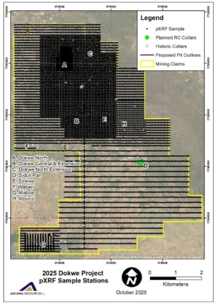
Portable XRF analysis for over 10,000 soil samples were collected across the tenement area. Samples were collected on a grid of 50 m by 200 m, reducing spacing to 50 m by 100 m in areas of priority interest. Once the soil sample is dry, a pXRF reading is taken from the soil sample to obtain multi-element geochemistry. The pXRF unit used was an Olympus Vanta. QA/QC samples were utilised at the start of each session and then at approximately every 100 readings.
-
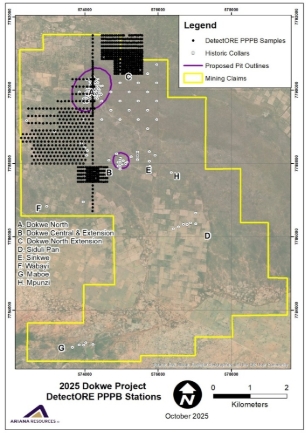
Next, a 250g sub-sample is weighed and placed into a plastic pouch with 500ml of reagent added and a collector device (CD) attached to the inside of the cap of the pouch. The pouches are placed in a barrel and tumbled for 12 hours. After this, the pouches are removed from the drum and CDs are removed from the pouches, rinsed gently in water, and dried in a dehydrator oven for three hours. This detectORETM technology has been used to analyse 811 of the pXRF soil samples from priority areas.
-
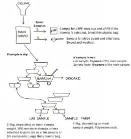
Reverse circulation drill samples taken in 2025 - 2026 were split using a multi-tiered splitter to obtain a 3-5kg representative sample for dispatch to the laboratory. RC chip samples for every meter were collected straight from the drill rig using a sample cyclone. Wet samples were speared multiple times to obtain a representative sample mass. Less than 10% of the obtained samples were wet. The drill rig cyclone was typically cleaned after every rod run (3m).
|
|
Drilling techniques
|
-
Drill type (eg core, reverse circulation, open-hole hammer, rotary air blast, auger, Bangka, sonic, etc) and details (eg core diameter, triple or standard tube, depth of diamond tails, face-sampling bit or other type, whether core is oriented and if so, by what method, etc).
|
-
Diamond drillholes were collared with HQ core size (63.5mm diameter) to a more competent ground and then continued with NQ core size (47.6mm diameter) to the end of drillhole. Some drillholes drilled between 2003 and 2007 were drilled with narrower BQ core size (36.4mm diameter). The diameter of the percussion drillholes was 152mm. Diamond drillholes drilled in 2020 for metallurgical purposes were collared with PQ core size (85mm) to more competent ground and then continued with HQ core to the end of hole and the diameter of sterilisation percussion drillholes was 133mm. Diamond drillholes drilled in 2023-2024 for due diligence purposes were predominantly drilled using standard HQ drill rods. However, some holes were collared with PQ-sized rods to approximately 100m. Deeper holes (>250 metres), were drilled to final depth using NQ rods after HQ (DPD132).
-
The drill core from 2019-2023 was oriented using the Boart Longyear TruCoreTM UPIX core orientation system. The NQ core was oriented but highly weathered and broken HQ core was not oriented. The whole of the geotechnical drillhole core was oriented. The due diligence drillholes (DPD129 - DPD132) core were oriented.
-
Reverse Circulation drilling completed in 2025 - 2026 used a Thor 5000 drill rig with a 5-inch hammer size and 24 bars of air pressure on the rig, with an additional 14 bars of pressure from an off-rig booster. All RC holes drilled were surveyed using a multishot and later gyroscopic survey tool on approximately 20m intervals.
-
2026 Metallurgical Diamond Drilling was completed using a Chinese drill rig with a core size of HTW (70 mm) and NTW (56 mm). Downhole surveys were completed using a compatible survey tool.
|
|
Drill sample recovery
|
-
Method of recording and assessing core and chip sample recoveries and results assessed.
-
Measures taken to maximise sample recovery and ensure representative nature of the samples.
-
Whether a relationship exists between sample recovery and grade and whether sample bias may have occurred due to preferential loss/gain of fine/coarse material.
|
-
Drillhole recoveries were measured during each diamond drilling campaign and a total average recovery of 94% was achieved for the diamond drillholes to 2020, whereas 73% was achieved for the 2021 sterilisation percussion drillholes. However, recovery data pertaining to the percussion drillholes (32 drillholes) and five additional diamond drillholes drilled between 2003 and 2004 were not available at the time of reporting. Recovery for the 2023-2024 programme was 98.62%.
-
The sample recoveries were maximised through drilling techniques and consistent monitoring.
-
Sample recoveries versus grade relationships were not assessed. It is the CP’s opinion that there is no bias with respect to drilling technique and sampling methodology utilised. Sample recovery is poorer in the cover sequence in which there is not any gold.
-
Drill sample recovery for the 2025 - 2026 RC drilling was monitored by weighing each raw sample directly from the cyclone for every meter. The average sample mass of all samples was 32kg (80% recovery). Samples with poor recovery (i.e. <40%) were dominantly samples from within 10 meters of the surface, where poor recoveries are expected due to the lithology (Kalahari sands). No mineralisation intervals were documented within the first 10 metres of any of the holes drilled.
-
Recovery for all 2026 diamond drilling programmes was over 97%.
|
|
Logging
|
-
Whether core and chip samples have been geologically and geotechnically logged to a level of detail to support appropriate Mineral Resource estimation, mining studies and metallurgical studies.
-
Whether logging is qualitative or quantitative in nature. Core (or costean, channel, etc) photography.
-
The total length and percentage of the relevant intersections logged.
|
-
All drillholes drilled on Dokwe Project were logged geologically and the logging included “from” and “to” depth, lithology, colour, grain size, weathering, oxidation, and mineralisation.
-
All drillholes have been geologically logged to a level of detail to support Mineral Resource estimation.
-
Drillhole logging is qualitative in nature.
-
Core photography is completed wet and dry for every meter of every hole, with photographs labelled and stored systematically for reference.
-
All diamond core and percussion chips were completely logged from the top to the bottom of drillhole including all intersections.
-
RC chips for every metre of drilling completed during the 2025 - 2026 campaign were sieved, washed and logged. A full archive of chips has been retained for every metre drilled. These have been photographed in their respective chip trays for further documentation. Geological logs are digitised and loaded into Leapfrog software to review.
|
|
Sub-sampling techniques and sample preparation
|
-
If core, whether cut or sawn and whether quarter, half or all core taken.
-
If non-core, whether riffled, tube sampled, rotary split, etc and whether sampled wet or dry.
-
For all sample types, the nature, quality and appropriateness of the sample preparation technique.
-
Quality control procedures adopted for all sub-sampling stages to maximise representivity of samples.
-
Measures taken to ensure that the sampling is representative of the in situ material collected, including for instance results for field duplicate/second-half sampling.
-
Whether sample sizes are appropriate to the grain size of the material being sampled.
|
-
During sampling, samples were marked at 1m intervals apart from where the sampling crossed lithological boundaries where each side of the lithological contact was sampled separately.
-
After logging and marking of samples, the diamond drill core was then split in half by a diamond saw with one half stored for future reference and the other half core was sent to the laboratory for analyses.
-
Diamond drill core was logged from the top to the bottom of the drillhole including all the intersections, after logging, the drill core was marked for sampling by a senior geologist. The core was sampled nominally in 1m length apart from where sampling crossed lithological boundaries where each side of the boundary was sampled separately. Drill core was split in half with a diamond saw with one half core sample bagged in a plastic bag and then sent to the laboratory and the other half was retained in the core trays. In most drillholes, the entire core was sampled apart for the younger sedimentary cover. In later drillholes, only the mineralised portions of the drill core were sampled.
-
During percussion drilling, samples were collected every 1m into a large plastic bag and then split using a riffle splitter to desired amount for the laboratory analysis.
-
Sample representativity was tested by taking field duplicates and internal laboratory duplicates.
-
Sample size is in line with international practice and is appropriate to the grain size of the material being sampled.
-
Sample preparation and handling for the 2025 - 2026 RC drilling were all completed at the drill site as each hole progressed. The illustration below is a summary of the sample splitting procedure used during this programme.
-
2026 metallurgical drilling: Half-core was used for metallurgical testwork, with quarter-core used for laboratory assay and quarter-core retained in the core tray.
|
|
Quality of assay data and laboratory tests
|
-
The nature, quality and appropriateness of the assaying and laboratory procedures used and whether the technique is considered partial or total.
-
For geophysical tools, spectrometers, handheld XRF instruments, etc, the parameters used in determining the analysis including instrument make and model, reading times, calibrations factors applied and their derivation, etc.
-
Nature of quality control procedures adopted (eg standards, blanks, duplicates, external laboratory checks) and whether acceptable levels of accuracy (ie lack of bias) and precision have been established.
|
-
Sample analyses were carried out at Performance Laboratories, Antech Laboratories, SGS Lakefield Research Africa, Intertek Genalysis Laboratories and ALS Global in South Africa.
-
Sample preparation at Antech laboratories involved drying the sample, crushing, pulverising, riffle splitting, and packaging. A small portion of the pulverised material, 50g, was analysed for gold by fire assay with atomic absorption (“AA”) finish.
-
At Intertek Genalysis South Africa, the sample preparation involved drying the sample, crushing, pulverising, riffle splitting, and packaging. After going through the sample preparation stages, the final sample for analysis weighed approximately 50g and was shipped to Australia for analysis. All samples were assayed for gold by 50g fire assay with optical emission spectrometers (“OES”) finish.
-
Details pertaining to the analytical procedure at SGS Lakefield Research Africa was not available at the time of reporting.
-
Analytical techniques utilised at the laboratories are considered total.
-
No assay methods other than those conducted at the accredited laboratory (Performance, Antech, Intertek Genalysis, SGS Lakefield Research Africa Laboratory), were utilised in the generation of the Dokwe sampling database. Note that the details pertaining to the accreditation status for SGS Lakefield Research Africa Laboratory was not available, however, this data was not used in the resource estimation.
-
An adequate number of control samples were utilised during core sampling.
-
Between 2003 and 2007, blanks and duplicates were inserted into the sampling sequence. Between 2008 and 2011, CRMs, blanks and duplicates were inserted into the sampling sequence.
-
During 2019 and 2020 sampling campaigns, the QA/QC protocol for insertion of QA/QC samples was that one in every 10th sample sent to the laboratory will either be a blank or one of the four CRM.
-
During the 2023 sampling, every batch of 34 samples sent to Antech included 1 CRM, 1 blank, 1 field duplicate and 1 pulp duplicate.
-
During Ariana’s 2023 due diligence review of the Dokwe Project approximately 10% of samples extracted from DPD129 (Dokwe North) and DPD131 (Dokwe Central) were duplicated as quarter core and sent to ALS Global in South Africa for check analysis against the Antech laboratory in Zimbabwe. Results are satisfactory.
-
pXRF readings are taken on diamond drill core using a 3-beam Vanta M Series (VMR) with test timings set to Beam 1: 30s – Beam 2: 20s – Beam 3: 20s. Soil samples for pXRF are collected and air dried prior to analysis. Test timings for soils are set to Beam 1: 40s – Beam 2: 30s – Beam 3: 30s. For all pXRF analyses the unit is calibrated (cal check) at the start of the session. Following this, other QA/QC samples (blank, CRM, calibration disc) were utilised at the start and end of each session and at approximately every 100 readings.
-
For detectORETM analyses, each batch of 90 samples contains two reference materials supplied by Portable PPB which are processed and analysed in the same way as the other samples. The reference materials are not certified but have known concentrations of gold. They are used to check that the leach and collection process has worked as intended for that batch. In addition, two blanks and two field duplicates were included in every 90 samples. The pXRF detectORETM mode is firmware installed on portable XRF devices to allow detection of gold values from the CD’s, controlled via API coupled to pLIMS™ software that also manages the QA/QC. The pXRF detectORETM mode is calibrated using five Calibrated Collector Devices of varying concentrations of gold from 0 to 1,000 ppb equivalent. Once dried, the CDs are analysed for gold using Evident’s detectORETM mode on a Vanta M Series (VMR) pXRF.
-
RC samples from DRC1 - DRC22 were submitted to the Antech Laboratory and subjected to the same 50g shot assay procedure as used in all other programs described above. Samples from DRC22 – DRC31 were submitted to Performance Laboratories. An adequate number of control samples were utilised during RC sampling.
-
Current drilling programmes use both Antech and Performance laboratories to improve efficiency, with 10% of samples from each lab also being analysed at the other lab. Antech Laboratories and Performance Laboratories are both SADCAS accredited (ISO/IEC 17025:2017). Antech: 17 samples per batch (including 1 CRM and alternating 1 duplicate or 1 blank) at a 11.8% insertion rate. Performance: 19 samples per batch (including 1 CRM and alternating 1 duplicate or 1 blank) at a 10.5% insertion rate. Each lab also includes their own internal CRMs, blanks and duplicates. QA/QC results are satisfactory.
|
|
Verification of sampling and assaying
|
-
The verification of significant intersections by either independent or alternative company personnel.
-
The use of twinned holes.
-
Documentation of primary data, data entry procedures, data verification, data storage (physical and electronic) protocols.
-
Discuss any adjustment to assay data.
|
-
Dokwe North is an advanced exploration property that has a database with 103 diamond drillholes, 7 RC drillholes, 15 percussion drillholes and 25 sterilisation RC drillholes.
-
Less than 2km SE, Dokwe Central has 24 diamond drillholes, 12 RC drillholes and 5 percussion holes and has been audited by Digital Mining Services (DMS) in the past.
-
In addition to the Dokwe North and Central holes 42 holes have been drilled in prospects in the vicinity of Dokwe.
-
As part of verification, the QA/QC for the various drilling campaigns were reviewed and the drilling database was verified.
-
The original Dokwe drilling database was in the form of Microsoft Access database. The Dokwe drillhole database included 2003-2004, 2007, 2008, 2009, 2010, 2019 and 2020 drilling campaigns. The database was checked for duplicates, overlapping, and missing intervals, whilst all fields were checked for spurious or out-of-range values. The database has been uploaded to MXDeposit as part of the Due Diligence study.
-
The Due Diligence drilling included a twin hole (DPD129), which correlated very well with its twin DPD49.
-
For detectORETM analyses all samples and sample information are tracked using the bar codes on the pouches and the CD’s. The sample numbers are entered into proprietary pLIMSTM software, Portable PPB’s software interface for sample management and results. The barcodes prevent manual errors in data entry.
-
For detectORETM analyses the gold concentration is calculated based on the weight of the original sample and moisture content, and the amount of gold on the CD (i.e., gold leached into solution). The gold concentration is given as dU (detectORETM units), where a dU represents the leached and collected gold in micrograms of gold. This is a partial extraction, not a total gold result. The laboratory results from the trial batches are compared to the detectORETM results, and a correlation coefficient is established. This equation is used to predict the ppm (g/t) values the dU correlates with, and thus help define samples to be analysed at a laboratory using conventional assay. The detectORE™ results when compared to fire assays also provide detailed geometallurgical insights and leach characteristics, further adding value to this process.
-
During pXRF analyses, samples are analysed in numerical order, and a sheet is completed to note the inserted QA/QC samples. These are digitised and combined with the data export from the pXRF on a daily basis. No adjustment is made to pXRF data for soils or core in the raw data set.
|
|
Location of data points
|
-
Accuracy and quality of surveys used to locate drill holes (collar and down-hole surveys), trenches, mine workings and other locations used in Mineral Resource estimation.
-
Specification of the grid system used.
-
Quality and adequacy of topographic control.
|
-
The coordinate utilised for Dokwe is WGS84 Universal Transverse Mercator (“UTM”) Zone 35 South.
-
All drillhole collars up have been surveyed by qualified professional surveyors Drysdale and Associates using RTK GPS (3 – 5mm accuracy) which is linked to the national grid. The coordinates were provided in Universal Transverse Mercator (“UTM”) on Cape Datum.
-
During 2019 and 2020 drilling programme, all drillholes were downhole surveyed at 6m intervals using Boart Longyear – TruShotTM digital survey tools. In order to obtain the complete survey of the holes, the surveys were done separately for the HQ and NQ diameter of the holes. Earlier drillholes (DPD001 – 010) were downhole surveyed at 50m intervals using Reflex EZ- Shot™ equipment. Subsequently drillholes were downhole surveyed with Reflex EZ-Shot (Reflex single shot) and DeviFlexi tools and were surveyed at 25m and from DPD060 to DPD084 the interval decreased to 4m to 6m. No downhole survey was carried out on the percussion drillholes and six diamond drillholes drilled between 2003 and 2004 as well as the sterilisation drillholes drilled in 2021. Downhole surveys were carried out for the 2023-24 drilling.
-
In 2016, Southern Mapping Company (Pty) Ltd, was contracted by Canister to carry out a LiDAR survey of the topography. This was tied into WGS84 with better than 10cm accuracy, non-ground points were filtered out and an orthophoto and topographical contours were generated at 0.5m contour intervals.
-
In 2023, a drone survey over the Dokwe North area captured 2,600 detailed 12-megapixel aerial images to produce a high- resolution (4cm/pixel) photogrammetry map. This was used to validate and locate all historic collars within the immediate Dokwe North area to within 1m accuracy.
-
Collar positions of the 2025 – 2026 RC drilling were recorded in the field by handheld GPS, and later by DGPS. Each collar was preserved by a concrete block with the hole ID and coordinates clearly engraved. Downhole surveys for the 2025 - 2026 RC drilling were completed on 20m intervals using an OMNIx42 multishot tool, and then later after the first four holes a DeviGyro gyroscopic survey tool.
-
Collar positions of the 2026 metallurgical and geotechnical drilling were marked and collected by DGPS before the start of drilling. Downhole surveys were completed using survey tools (JTL-40GX and KXP-2A) compatible with Chinese core sizes.
-
Collar positions of the 2026 exploration drilling were marked by GPS, and collected by DGPS post drilling.
-
Collar positions of the 2026 geotechnical drilling were marked by DGPS prior to drilling commencing.
|
|
Data spacing and distribution
|
-
Data spacing for reporting of Exploration Results.
-
Whether the data spacing and distribution is sufficient to establish the degree of geological and grade continuity appropriate for the Mineral Resource and Ore Reserve estimation procedure(s) and classifications applied.
-
Whether sample compositing has been applied.
|
-
Data spacing and distribution are sufficient to establish the degree of geological and grade continuity appropriate for the Mineral Resource estimation and classification.
-
A 1m compositing interval was selected and applied to the de- surveyed drillholes. Composites were selected from all drill holes except sterilisation RC holes.
DOKWE NORTH
-
A total of 166 drillholes (including percussion and geotechnical drillholes) have been drilled at Dokwe North. At Dokwe North, drillholes were systematically laid out on section lines (approximately 320º azimuth) spaced 50m apart and the collars were also spaced at 50m along the section lines.
-
Of these 166 holes, a total of 25 sterilisation percussion drillholes were drilled on a square grid of 350m over the proposed waste dump, plant, heap leach, tailings dam, and solar farm sites to the southeast of Dokwe North.
-
The total metres drilled within the resource area (i.e. excluding sterilisation holes) is 37,777m (141 holes).
DOKWE CENTRAL
-
A total of 50 drillholes (including percussion drillholes) have been drilled at Dokwe Central. At Dokwe Central, most drillholes were systematically laid out on 3 section lines (E-W azimuth) spaced 50m apart and the collars were also spaced at 25m along the section lines, resulting in an average of 30m between holes.
-
In the resource area there are 6,834m (24 holes).
|
|
Orientation of data in relation to geological structure
|
-
Whether the orientation of sampling achieves unbiased sampling of possible structures and the extent to which this is known, considering the deposit type.
-
If the relationship between the drilling orientation and the orientation of key mineralised structures is considered to have introduced a sampling bias, this should be assessed and reported if material.
|
-
Dokwe North drillholes were systematically laid out on a section line (approximately 320º azimuth) generally perpendicular to the strike and most of the drillholes were drilled towards the northwest to intersect the mineralised orebodies very close to normal relative to the reef plane.
-
At Dokwe Central, drillholes were systematically laid out on section lines (E-W azimuth) generally perpendicular to the strike and most of the drillholes were drilled towards the north to intersect the mineralised orebodies very close to normal relative to the reef plane.
-
Available information indicates that the drilling orientation would provide unbiased sampling of the mineralisation zones.
-
Due diligence drilling in 2023 drilled from various orientations to better test the mineralisation and confirm that the drilling has provided unbiased sampling.
-
The geotechnical drilling was also completed in various orientations.
-
2026 metallurgical drilling orientations were optimised to obtain the required quantities of mineralised material to be representative of the whole deposit.
-
2026 geotechnical drilling orientations were optimised to to be representative of the potential pit walls.
|
|
Sample security
|
-
The measures taken to ensure sample security.
|
-
The core was then transported to the core yard for geological logging and sampling. After logging and marking of samples, the diamond drill core was then cut in half by a diamond saw with one half stored for future reference and the other half core was sent to the laboratory for analyses.
-
During percussion drilling, samples were collected in large bags and then split using a sample riffle splitter. After splitting, samples were bagged in plastic bags, the remaining bulk sample was transported to the main office about 125km from site and stored at a shed in the early years, but stored on site in the recent sterilization programme.
-
All samples were transported by company personnel to the laboratory. They were signed off for dispatch from the core yard and on receipt to the laboratory.
-
All drill core is stored at the Dokwe Camp.
-
RC drilling completed during 2025 – 2026: all samples were handled on the active drill sites. Split samples for laboratory analysis were bagged, securely sealed, and stored at the base camp sample dispatch (approximately 2km from the drill sites) until ready to be sent directly to Antech Laboratories and Performance Laboratories.
|
|
Audits or reviews
|
-
The results of any audits or reviews of sampling techniques and data.
|
-
In 2008 Digital Mining Services completed a data review and verification of the drilling results to date.
-
The sampling for the Due Diligence study and all drilling since 2023 has been supervised by the CP of this MRE and senior members of Ariana Resources.
|
Section 2 Reporting of Exploration Results
(Criteria listed in the preceding section also apply to this section.)
|
Criteria
|
JORC Code explanation
|
Commentary
|
|
Mineral tenement and land tenure status
|
-
Type, reference name/number, location and ownership including agreements or material issues with third parties such as joint ventures, partnerships, overriding royalties, native title interests, historical sites, wilderness or national park and environmental settings.
-
The security of the tenure held at the time of reporting along with any known impediments to obtaining a licence to operate in the area.
|
-
Ariana owns 100% of the Dokwe Project following the all-share merger with Rockover Holdings Limited in June 2024.
-
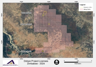
Dokwe is held through 81 blocks of gold claims and 22 copper base metal claims totalling 4,040ha which are protected up until at least August 2026. The claims can be extended through annual inspection. Canister made application to the Ministry of Mines and Mining Development in March 2021 under Part VIII of the Mines and Minerals Act (MMA) to convert the claims into a Mining Lease with the aim is to facilitate the development of a significant new gold mine at Dokwe. The Mining Lease application is for gold and base metals, and the area applied for is 6,622ha. The Ministry requested additional information in support of the application which has been submitted.
-
The Project is currently not subjected to payment of royalties or other payments. Government royalties will be payable once mining operations are developed. A private royalty of 0.5% will also be payable once production starts.
-
As far as the CP is aware, no statutory instrument has been gazetted implementing an environmental fund as yet, so no fees are due or anticipated. In addition, the CP is not aware of any requests being made to Rockover by the Minister to implement an environmental fund. As such, no environmental rehabilitation trusts and guarantees have been established for Dokwe.
|
|
Exploration done by other parties
|
-
Acknowledgment and appraisal of exploration by other parties.
|
-
Acknowledgement is hereby made for the historical exploration conducted by Reunion Mining in 1993. Reunion Mining undertook a detailed airborne magnetic survey over an area of approximately 1,000km2. The detailed airborne magnetic survey indicated the presence of an east-northeast trending linear magnetic feature buried beneath the younger sedimentary cover. This magnetic data forms part of the database used in the interpretation of the Exploration Results.
|
|
Geology
|
-
Deposit type, geological setting and style of mineralisation.
|
GENERAL DOKWE AREA
-
The Dokwe gold deposits are situated in Archaean basement rocks buried by up to 40 metres of Karoo and Kalahari sedimentary cover.
-
The Dokwe area can be subdivided into a number of litho-structural domains which are juxtaposed against each other by a series of shear zones. The three known gold occurrences within the Claims Area are within shear zones, which have a combined strike length of approximately 12km.
DOKWE NORTH
-
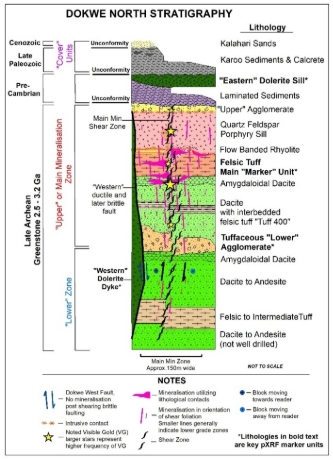
The geology of Dokwe North primarily consists of a sequence of Late Archean-aged greenstone volcaniclastics. These include dacite-to-andesite flows featuring amygdaloidal rich horizons, interbedded felsic tuffs, agglomerates, and irregular rhyolite flows.
-
The sequence is intruded by earlier quartz-feldspar porphyries and later altered dolerite. Brittle deformation, characterised by fracturing, is common in felsic tuff whilst more ductile deformation characterises dacite and andesite.
-
A major brittle fault, the “Western” fault is post-mineralised structure dissecting offsetting mineralisation.
-
The main Dokwe North orebody occurs within a NE-SW trending shear zone that displays a central core with intense foliation and mylonitisation of the host rocks.
-
Primary gold mineralisation at Dokwe is preserved as free gold and occasionally as inclusions in quartz veins, micro-fractures in pyrite, and other open-space micro-features.
-
The mineralisation is primarily structurally controlled and associated with the intensity of shearing and with lithological contacts. Visible gold has been documented multiple times and is often associated within the foliation planes formed by shearing.
-
Overlying all the basement stratigraphy is a sequence of barren sedimentary rocks.
DOKWE CENTRAL
-
Dokwe Central is higher-grade pipe-like deposit containing abundant quartz veins and several steeply plunging high-grade zones. Mineralisation is contained within a series of strongly sheared intermediate chlorite schists and biotite-chlorite schists in a covered Archean Greenstone Belt, extending from the border with Botswana (Maitengwe Greenstone Belt) and linking up with the Bulawayo-Bubi Greenstone Belt to the east. The Archaean greenstone units are overlain by Karoo and Kalahari sedimentary units of up to 25-40m in thickness.
-
Mineralisation appears to be dominantly constrained within intensely sheared and brecciated zones, and in association with disseminated sulphides (dominantly pyrite).
-
The defined mineralisation extent is abruptly terminated against a package of sedimentary rocks to the north, marking a major east-west trending fault.
|
|
Drill hole Information
|
-
A summary of all information material to the understanding of the exploration results including a tabulation of the following information for all Material drill holes:
-
easting and northing of the drill hole collar
-
elevation or RL (Reduced Level – elevation above sea level in metres) of the drill hole collar
-
dip and azimuth of the hole
-
down hole length and interception depth
-
hole length.
-
If the exclusion of this information is justified on the basis that the information is not Material and this exclusion does not detract from the understanding of the report, the Competent Person should clearly explain why this is the case.
|
DOKWE NORTH
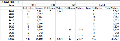
-
Drillhole database consists of a total of 166 drillholes totalling 39,527m. The database is split with:
-
119 diamond drillholes (incl. 5 geotechnical holes) totalling 35,159m.
-
15 percussion drillholes totalling 1,441m.
-
25 RC sterilisation holes totalling 1,750m.
-
7 RC drillholes totalling 1,177m.
DOKWE CENTRAL
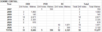
-
Drillhole database consisted of a total of 50 drillholes, totalling 11,277m. The database is split with:
-
33 diamond drillholes (incl. 5 geotechnical holes) totalling 8,606m.
-
5 percussion drillholes totalling 350m.
-
12 RC drillholes totalling 2,321m.
DOKWE AREA
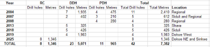
-
Drilling across the wider area includes 42 drillholes totalling 7,382m.
-
All collar information has been previously announced.
-
2026 Geotechnical Drilling collars are given below.
|
|
Data aggregation methods
|
-
In reporting Exploration Results, weighting averaging techniques, maximum and/or minimum grade truncations (eg cutting of high grades) and cut-off grades are usually Material and should be stated.
-
Where aggregate intercepts incorporate short lengths of high grade results and longer lengths of low grade results, the procedure used for such aggregation should be stated and some typical examples of such aggregations should be shown in detail.
-
The assumptions used for any reporting of metal equivalent values should be clearly stated.
|
-
The sample intervals from the raw de-surveyed drillhole dataset were analysed for the most appropriate composite length to be applied for geostatistical analysis. The mean of the population is 1.13m, with approximately 75% of the population being exactly 1m in length. Given the data, a 1m compositing interval was selected and applied to the de-surveyed drillholes. Composites were selected from all drill holes, except RC sterilisation drilling data.
-
No metal equivalents were calculated.
|
|
Relationship between mineralisation widths and intercept lengths
|
-
These relationships are particularly important in the reporting of Exploration Results.
-
If the geometry of the mineralisation with respect to the drill hole angle is known, its nature should be reported.
-
If it is not known and only the down hole lengths are reported, there should be a clear statement to this effect (eg ‘down hole length, true width not known’).
|
-
At Dokwe North, drillholes were systematically laid out on section lines (approximately 320º azimuth) generally perpendicular to the strike, and most of the drillholes were drilled towards the northwest to intersect the mineralised orebodies very close to normal relative to the structural plane.
-
At Dokwe Central, drillholes were systematically laid out on section lines (E-W azimuth) generally perpendicular to the strike and most of the drillholes were drilled towards the north to intersect the mineralised orebodies very close to normal relative to the reef plane.
-
Downhole true widths are not calculated. All significant grades presented represent the value attributable to the real sample length and not corrected true width.
|
|
Diagrams
|
-
Appropriate maps and sections (with scales) and tabulations of intercepts should be included for any significant discovery being reported. These should include, but not be limited to a plan view of drill hole collar locations and appropriate sectional views.
|
-
All relevant diagrams pertaining to sampling type and its distribution, as well as geological and block models are presented in their respective sections and have been generated in accordance with the guidelines described in the JORC Code (2012).
|
|
Balanced reporting
|
-
Where comprehensive reporting of all Exploration Results is not practicable, representative reporting of both low and high grades and/or widths should be practiced to avoid misleading reporting of Exploration Results.
|
-
The Mineral Resource Estimate is based on the information resulting from sampling and drilling campaigns. This Mineral Resource estimation summary contains information for all sampling and drilling campaigns within the Project Area to date.
-
All material intercepts have been previously announced, or announced in this announcement.
|
|
Other substantive exploration data
|
-
Other exploration data, if meaningful and material, should be reported including (but not limited to): geological observations; geophysical survey results; geochemical survey results; bulk samples – size and method of treatment; metallurgical test results; bulk density, groundwater, geotechnical and rock characteristics; potential deleterious or contaminating substances.
|
-
Exploration works other than drilling conducted by or on behalf of the issuer includes soil geochemistry, geophysical survey (induced polarisation survey, real section induced polarisation, magnetic survey), and lidar survey. Some of this data has been incorporated into the Mineral Resource Estimation work completed here.
-
Soil geochemistry surveys have been completed in the periphery of Dokwe North and at the Dokwe Central prospect. A total of 10,086 samples have been collected to date. detectORETM technology has been used to analyse 811 of these samples in the first instance.
-
pXRF soil sampling grid.
-
detectORETM soil sampling grid.
|
|
Further work
|
-
The nature and scale of planned further work (eg tests for lateral extensions or depth extensions or large-scale step-out drilling).
-
Diagrams clearly highlighting the areas of possible extensions, including the main geological interpretations and future drilling areas, provided this information is not commercially sensitive.
|
-
Further exploration will be carried out in the region, particularly exploring the downdip of Dokwe North. Additional target areas defined previously will also be followed up.
-
pXRF work is ongoing across all Dokwe North drillholes, and is being used in the geological modelling. Over 40,000 readings have been taken to date.
-
Follow up of significant grades intercepted in DPD004 approximately 800m east of Dokwe Central.
-
Exploration drilling at Dokwe North and Dokwe Central extensions.
|
NOTE: Sections 3, 4 and 5 are not relevant to this work as no mineral resources or ore reserves are being estimated and there is no estimation or reporting of diamonds or other gemstones in this project.