
Geophysical Survey Results & Investor Presentation
Summary by AI BETAClose X

Arc Minerals Ltd / EPIC: ARCM / Market: AIM / Sector: Mining
24 July 2026
Arc Minerals Ltd
("Arc" or "the Company")
Geophysical Survey Results & Investor Presentation
Arc Minerals (LSE: ARCM), an exploration company focused on discovering and developing Tier 1 copper deposits in Africa, is pleased to publish the results of its geophysical programme over the licence PL135/2017 of the Virgo project, inside the Zone 5 corridor of the Kalahari Copper Belt ('KCB') in the Republic of Botswana.
HIGHLIGHTS
· IP survey extends significantly the inferred contact between the D'Kar Formation and Ngwako Pan Formation ("DKF-NPF contact") within the licence to 18 kilometres ("km")
· Several high-priority anomalies identified with strong Induced Polarisation ("IP") chargeability/resistivity anomalies and areas of structural complexity creating favourable potential mineral trap sites
· Final selection of drilling contractor imminent. Drilling activities expected to commence in early August
· Project-specific presentation on Thursday 30th July at 16h30 BST
Remy Welschinger, Chief Executive Officer of Arc Minerals, commented:
"The results of the geophysical programme exceeded our expectations. The extent of the inferred DKF-NPF contact within our licence PL135/2017 is now 18 kilometres, over four times longer than we originally expected in previous years. Importantly, it is straddled, within metres, by two priority discoveries (Mawana Fold and Zone 9) within the Khoemacau mining project of MMG. I look forward to a very exciting drilling campaign ahead."
Geophysical Survey and Results
3D Earth Exploration (Pty) Ltd was contracted to conduct a ground magnetic and IP survey over the PL135/2017 licence, as a continuation from the 2024 IP survey.
The programme commenced with a ground magnetic survey and was dominated by a large magnetic feature in the east that corresponds to known Kgwebe volcanics that heavily affected the magnetic signature. After completing 230 line km, it was decided that the focus of the programme should remain on the IP survey, which had strongly identified the prospective DKF-NPF contact in the 2024 IP campaign. Nonetheless, the magnetic survey did pick up an area of structural complexity on the southern end of the Mawana Fold, which was further confirmed by the IP survey. This is now becoming an area of interest as it could potentially host mineral trap sites conducive to the formation of larger deposits.
The IP survey consisted of a total of 59 line km, made up of 51 line km of Gradient IP and 8 line km of Insight Section IP. The survey employed a Walcer TX KW10 transmitter and an Iris Elrec Terra IP receiver. For both Gradient Array and Insight Section IP, a 25m dipole was used during measurements with a reading cycling time of 20 to optimize data quality by increasing signal to noise ratio. The survey lines were designed to cover the full extent of the inferred DKF-NPF contact across the licence and interpreted redox boundary.
The IP survey appears to have extended the interpreted redox boundary (DKF-NPF Contact) by a further 14 kilometres (Figure 1) to the east of the area surveyed in 2024, bringing the total contact length in the licence to 18 kilometres (Figure 2).
The D'Kar Formation is typically characterised by high apparent chargeability and low apparent resistivity and occupies the southern side of the interpreted redox contact, whilst the northern side of the contact is assumed to be the Ngwako Pan Formation.
A redox contact jog has been noted in the central part to the area surveyed and could also be an area to target for economic mineralization.
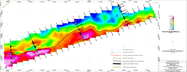
Figure 1. Apparent chargeability faded contoured image showing the redox contact (DKF-NPF Contact), insight sections and chargeability anomalies along the insight sections.

Figure 2. Inferred DKF-NPF contact from the 2024 and 2026 IP surveys (unlevelled) within prospecting licence PL135/2017, surrounded by Mawana Fold and Zone 9 discoveries.
INVESTOR PRESENTATION
Arc also announces that CEO Remy Welschinger will provide a live presentation related to the Virgo Project via Investor Meet Company on 30 July 2026 at 16:30 BST.
The presentation is open to all existing and potential shareholders. Questions can be submitted pre-event via your Investor Meet Company dashboard up until 29 Jul 2026, 18:00 BST. Investors can sign up to Investor Meet Company for free and add to meet Arc Minerals via: https://www.investormeetcompany.com/arc-minerals-limited/register-investor
Investors who already follow Arc Minerals on the Investor Meet Company platform will automatically be invited.
Qualified Person
Mr Vassilios Carellas (BSc (Hons), MAusIMM) is the Chief Operating Officer for Arc Minerals and has sufficient experience relevant to the style of mineralisation and type of deposit under consideration and to the activity which he is undertaking to qualify as a Competent Person as defined under the JORC Code (2012). Mr Carellas consents to the inclusion in this announcement of the technical matters based on his information in the form and context in which it appears.
Market Abuse Regulation (MAR) Disclosure
This announcement contains inside information for the purposes of Article 7 of the Market Abuse Regulation (EU) 596/2014 as it forms part of UK domestic law by virtue of the European Union (Withdrawal) Act 2018 ("MAR"), and is disclosed in accordance with the Company's obligations under Article 17 of MAR.
ENDS
For further information visit www.arcminerals.com or contact:
|
Arc Minerals Ltd
|
Rémy Welschinger, CEO |
E: info@arcminerals.com |
|
Zeus Capital Ltd Nominated Adviser & Joint Broker
|
Katy Mitchell / Harry Ansell |
T: +44 (0) 20 3829 5000 |
|
Shard Capital Partners LLP Joint Broker
|
Damon Heath |
T: +44 (0) 20 7186 9952 |
Notes
Arc Minerals Ltd (LSE: ARCM) is an AIM-quoted copper exploration company focused on developing assets across two of Africa's most prospective copper belts. The Virgo Project, in Botswana, is situated in the Kalahari Copper Belt within the highly prospective MMG Zone 5 corridor. The Company also holds the Kabompo West Project in Zambia, located within the Western Domes of the Central African Copper Belt, host to multiple Tier 1 copper deposits. Arc is led by an experienced team with expertise across mining, capital markets and in-country operations.
Appendix A.
JORC Code, 2012 Edition - Table 1 Report
Section 1 Sampling Techniques and Data
|
Sampling techniques |
· Nature and quality of sampling (eg cut channels, random chips, or specific specialised industry standard measurement tools appropriate to the minerals under investigation, such as down hole gamma sondes, or handheld XRF instruments, etc). These examples should not be taken as limiting the broad meaning of sampling. · Include reference to measures taken to ensure sample representivity and the appropriate calibration of any measurement tools or systems used. · Aspects of the determination of mineralisation that are Material to the Public Report. · In cases where 'industry standard' work has been done this would be relatively simple (eg 'reverse circulation drilling was used to obtain 1 m samples from which 3 kg was pulverised to produce a 30 g charge for fire assay'). In other cases more explanation may be required, such as where there is coarse gold that has inherent sampling problems. Unusual commodities or mineralisation types (eg submarine nodules) may warrant disclosure of detailed information. |
No sampling activities have been undertaken or reported for.
|
||
|
Drilling techniques |
· Drill type (eg core, reverse circulation, open-hole hammer, rotary air blast, auger, Bangka, sonic, etc) and details (eg core diameter, triple or standard tube, depth of diamond tails, face-sampling bit or other type, whether core is oriented and if so, by what method, etc). |
No drilling has been undertaken or reported for.
|
||
|
Drill sample recovery |
· Method of recording and assessing core and chip sample recoveries and results assessed. · Measures taken to maximise sample recovery and ensure representative nature of the samples. · Whether a relationship exists between sample recovery and grade and whether sample bias may have occurred due to preferential loss/gain of fine/coarse material. |
No drilling has been undertaken or reported for.
|
||
|
Logging |
· Whether core and chip samples have been geologically and geotechnically logged to a level of detail to support appropriate Mineral Resource estimation, mining studies and metallurgical studies. · Whether logging is qualitative or quantitative in nature. Core (or costean, channel, etc) photography. · The total length and percentage of the relevant intersections logged. |
No drilling has been undertaken or reported for. |
||
|
Sub-sampling techniques and sample preparation |
· If core, whether cut or sawn and whether quarter, half or all core taken. · If non-core, whether riffled, tube sampled, rotary split, etc and whether sampled wet or dry. · For all sample types, the nature, quality and appropriateness of the sample preparation technique. · Quality control procedures adopted for all sub-sampling stages to maximise representivity of samples. · Measures taken to ensure that the sampling is representative of the in situ material collected, including for instance results for field duplicate/second-half sampling. · Whether sample sizes are appropriate to the grain size of the material being sampled. |
No drilling has been undertaken or reported for. |
||
|
Quality of assay data and laboratory tests |
· The nature, quality and appropriateness of the assaying and laboratory procedures used and whether the technique is considered partial or total. · For geophysical tools, spectrometers, handheld XRF instruments, etc, the parameters used in determining the analysis including instrument make and model, reading times, calibrations factors applied and their derivation, etc. · Nature of quality control procedures adopted (eg standards, blanks, duplicates, external laboratory checks) and whether acceptable levels of accuracy (ie lack of bias) and precision have been established. |
No drilling has been undertaken or reported for. |
||
|
Verification of sampling and assaying |
· The verification of significant intersections by either independent or alternative company personnel. · The use of twinned holes. · Documentation of primary data, data entry procedures, data verification, data storage (physical and electronic) protocols. · Discuss any adjustment to assay data. |
No drilling has been undertaken or reported for. |
||
|
Location of data points |
· Accuracy and quality of surveys used to locate drill holes (collar and down-hole surveys), trenches, mine workings and other locations used in Mineral Resource estimation. · Specification of the grid system used. · Quality and adequacy of topographic control. |
No mineral resource estimation activities have been undertaken or reported for. |
||
|
Data spacing and distribution |
· Data spacing for reporting of Exploration Results. · Whether the data spacing and distribution is sufficient to establish the degree of geological and grade continuity appropriate for the Mineral Resource and Ore Reserve estimation procedure(s) and classifications applied. · Whether sample compositing has been applied. |
No minerals resource estimation activities have been undertaken or reported for. |
||
|
Orientation of data in relation to geological structure |
· Whether the orientation of sampling achieves unbiased sampling of possible structures and the extent to which this is known, considering the deposit type. · If the relationship between the drilling orientation and the orientation of key mineralised structures is considered to have introduced a sampling bias, this should be assessed and reported if material. |
No sampling activities have been undertaken or reported for. No drilling has been undertaken or reported for.
|
||
|
Sample security |
· The measures taken to ensure sample security. |
No sampling activities have been undertaken or reported for. |
||
|
Audits or reviews |
· The results of any audits or reviews of sampling techniques and data. |
No sampling activities have been undertaken or reported for.
|
||
Section 2 Reporting of Exploration Results
(Criteria listed in the preceding section also apply to this section.)
|
Mineral tenement and land tenure status |
· Type, reference name/number, location and ownership including agreements or material issues with third parties such as joint ventures, partnerships, overriding royalties, native title interests, historical sites, wilderness or national park and environmental settings. · The security of the tenure held at the time of reporting along with any known impediments to obtaining a licence to operate in the area. |
Alvis-Crest Proprietary Limited owns 100% of the PL 135/2017 licence. The two shareholders of Alvis-Crest Proprietary Limited are Arc Minerals Limited and Global Exploration Technologies who own 75% and 25% respectively. The PL135/2017 licence expires on the 30th of September 2026. The Company has put in an application to extend the licence for a further two years.
. |
|
Exploration done by other parties |
· Acknowledgment and appraisal of exploration by other parties. |
Former Anglo American prospective ground covered by widely spaced soil sampling that picked up copper in soils resulting in the Boseto-Khoemacau mines that are operated by MMG today. Several deposits exist within the vicinity and surrounding areas where future mining might take place. Acquiring the Virgo Prospecting licences from Kopore Metals is the beginning of a long journey for Alvis Crest in the Kalahari Copperbelt. Within 20 kilometres is the Zone 5 deposit for MMG Khoemacau Copper Mines to a tune of 92 million tonnes of copper ore at 2.2%Cu. Within 120 kilometres is the Sandfire Motheo Project being developed with 67 million tonnes of copper ore at 0.85%Cu. Within 70 kilometres is the Banana deposit for MMG Khoemacau Copper Mines with 187 million tonnes of copper ore at 0.80%Cu. The Virgo project lie within highly prospective ground of the Kalahari Copperbelt and needs to be explored further to realize the potential of copper ore in the area.
|
|
Geology |
· Deposit type, geological setting and style of mineralization.. |
The Alvis Crest deposits are characterised as a structurally controlled strata-bound sediment-hosted copper deposit. Copper-silver mineralisation typically occurs at the stratigraphic and/or structural boundary between the contact of the oxidised Ngwako Pan Sandstone Formation and reduced D'Kar siltstone Formation. The boundary is both a chemically reduced and structurally controlled trap environment. Host rocks are unconformably overlain by unconsolidated Kalahari Sand and calcrete up to 60m thick. The lower ductile siltstones and carbonaceous units of the D'Kar Formation are the main host for most of the copper and silver mineralisation. The D'Kar rocks are composed of shallow marine sediments deposited >981 +/- 3 Ma (millions of years ago) and consist of finely laminated and chemically reduced mudstones and siltstones intercalated with carbon rich limestone and thin lagoonal black shale. Economic grades are dominantly related to shearing, folding and tensional failure along and close to the Ngwako Pan and D'Kar redox contact. Disseminated and hydrothermal vein-hosted sulphide mineralisation styles combine to produce continuity of high-grade copper and silver mineralisation over tens of kilometres. These higher-grade copper sulphide zones typically contain disseminated cleavage parallel lenticles and massive quartz-carbonate and breccia veins hosting chalcopyrite, bornite and chalcocite mineralisation. Sulphide assemblages are commonly zoned. The sequence is developed vertically upward from the base of the D'Kar Formation and can be seen to develop horizontally along strike at some deposits. The typical zonation sequence consists of low sulphur, low iron, copper sulphides (chalcocite and bornite) and passes upward with increasing iron content (chalcopyrite and pyrite). This sulphide zonation coincides with copper solubility precipitating of low soluble sulphides at the first reductant while chalcopyrite and pyrite remain in solution.
|
|
Drill hole Information |
· A summary of all information material to the understanding of the exploration results including a tabulation of the following information for all Material drill holes: o easting and northing of the drill hole collar o elevation or RL (Reduced Level - elevation above sea level in metres) of the drill hole collar o dip and azimuth of the hole o down hole length and interception depth o hole length. · If the exclusion of this information is justified on the basis that the information is not Material and this exclusion does not detract from the understanding of the report, the Competent Person should clearly explain why this is the case. |
No drilling has been undertaken or reported for.
|
|
Data aggregation methods on methods |
· In reporting Exploration Results, weighting averaging techniques, maximum and/or minimum grade truncations (eg cutting of high grades) and cut-off grades are usually Material and should be stated. · Where aggregate intercepts incorporate short lengths of high grade results and longer lengths of low grade results, the procedure used for such aggregation should be stated and some typical examples of such aggregations should be shown in detail. · The assumptions used for any reporting of metal equivalent values should be clearly stated. · |
No drilling has been undertaken or reported for. |
|
Relationship between mineralisation widths and intercept lengths |
· These relationships are particularly important in the reporting of Exploration Results. · If the geometry of the mineralisation with respect to the drill hole angle is known, its nature should be reported. · If it is not known and only the down hole lengths are reported, there should be a clear statement to this effect (eg 'down hole length, true width not known'). |
No drilling has been undertaken or reported for. |
|
Diagrams |
· Appropriate maps and sections (with scales) and tabulations of intercepts should be included for any significant discovery being reported These should include, but not be limited to a plan view of drill hole collar locations and appropriate sectional views. |
No geological plans or cross-sections are presented in this announcement. |
|
Balanced reporting |
· Where comprehensive reporting of all Exploration Results is not practicable, representative reporting of both low and high grades and/or widths should be practiced to avoid misleading reporting of Exploration Results. |
No drilling results are reported in this announcement. |
|
Other substantive exploration data |
· Other exploration data, if meaningful and material, should be reported including (but not limited to): geological observations; geophysical survey results; geochemical survey results; bulk samples - size and method of treatment; metallurgical test results; bulk density, groundwater, geotechnical and rock characteristics; potential deleterious or contaminating substances. |
3D Earth Exploration (Pty) Ltd ('3D') was contracted to conduct a ground magnetic and Induced Polarisation Survey over its PL135/2017 licence, as a continuation from the 2024 IP survey. A total 230 line km of ground magnetics were completed along with 59 line km surveyed made up of 51 km of Gradient IP and 8 km of insight Section IP.
For the ground magnetic survey, two G856AX proton precession magnetometers manufactured by Geometrics Inc. of USA were used in the ground magnetic survey. One was used at the base station to monitor drift variations whilst the other was used to record readings along the survey line. The One magnetometer was used as a base station automatically recording readings at 20- and 30-seconds interval. The roving magnetometer recorded readings at 5m intervals along survey lines. The data was downloaded daily and diurnal corrections done using Magmap 2000 Software. Pre-planned survey stations were located using a handheld GPS at 25m intervals. A rope was used to mark 5m stations between GPS stations as the survey was being done. All readings were checked to avoid recording bad readings and ensure high quality. Cultural features such drill collars were noted during the survey and incorporated into the data collected. This was a very important exercise as it enabled the removal of culture related data spikes during QAQC.
The IP survey employed a Walcer TX KW10 transmitter and an Iris Elrec Terra IP receiver. The survey lines were designed to cover the full extent of the inferred D'Kar and Ngwako Pan contact across the licence and interpreted redox boundary. For Gradient Array the current electrode spacing AB was 2000m on all surveys for a depth of investigation estimated at 400m (20% of AB). C1 was at station 0 and C2 at 2000N or 1000N and 3000N, to cover the southern and northern 1 km portions of the 2 km traverse lines.
The Insight Section IP survey consists of a number of readings at a given station at different current electrode separation representing different depths of investigation. The depth of each reading is 20% the current electrode spacing AB. Therefore, for depth levels from 50m to 400m at 50m intervals measured in this survey, the A-B separation was 250m to 2000m at 250m intervals, respectively.
The depth levels surveyed were at 50m intervals from 50m to 400m for all surveyed lines, corresponding to ABs from 250m to 2000m.
For both Gradient Array and Insight Section IP, a 25m dipole was used during measurements with a reading cycling time of 20 to optimize data quality by increasing signal to noise ratio.
Data was downloaded daily on return to the camp in the evening and processed using Geosoft's Oasis Montaj.
The following field processing was done: Download data for the survey line to date (from start to current day) into a laptop. The data was edited and XY coordinates in WGS84, Zone 34S inserted manually. Data was imported into a Geosoft database and gridded to produce chargeability and resistivity images which are then contoured. For Gradient Array data the grid cell size used is 125m (1/4 of 500m line spacing). For Insight Section IP, a cell size of 12.5m was used (1/4 of 50m depth layer separation) The Senior Geophysicist also gridded and QC'd the data on site daily before sharing with Alvis. The ground preparation for the following day was also adjusted according to the current output achieved on the day.
For both the magnetic and Induced polarisation survey the interpretation remains qualitative and subject to geological validation through follow-up drilling. Magnetic, chargeable and resistive features identified from these surveys are considered exploration targets only and require follow-up geological and drilling validation.
|
|
Further work |
· The nature and scale of planned further work (eg tests for lateral extensions or depth extensions or large-scale step-out drilling).
· Diagrams clearly highlighting the areas of possible extensions, including the main geological interpretations and future drilling areas, provided this information is not commercially sensitive. |
Proposed 'Further Work' is not covered in this announcement as at the time of going public the drill programme was not yet finalised. |
Section 3 Estimation and Reporting of Mineral Resources
Not Applicable
Section 4 Estimation and Reporting of Ore Reserves
Not Applicable
RNS may use your IP address to confirm compliance with the terms and conditions, to analyse how you engage with the information contained in this communication, and to share such analysis on an anonymised basis with others as part of our commercial services. For further information about how RNS and the London Stock Exchange use the personal data you provide us, please see our Privacy Policy.

Latest directors dealings
- 51 minutes ago Ninety One
- 1 hour ago Moneysupermarket.com Group
- 1 hour ago BlackRock Smaller Companies Trust
- 2 hours ago Rathbones Group
- 3 hours ago Sirius Real Estate Ltd.