Targeting Gold, Tungsten & Antimony at ELN Project
Summary by AI BETAClose X

NEWS RELEASE 24 NOVEMBER 2025
GREENX TARGETING GOLD, TUNGSTEN & ANTIMONY AT ELEONORE NORTH PROJECT IN GREENLAND
HIGHLIGHTS
· Outcropping gold and high-grade antimony mineralisation now confirmed at the Noa Prospect within the Eleonore North Project in East Greenland
· High-grade tungsten and antimony mineralisation also identified in Historical Estimate at the Margeries Prospects within the Eleonore North Project:
o 83kt of mineralised rock with a mean grade of 4.6% Sb at North Margeries
o 58kt of mineralised rock grading at 3.2% W at South Margeries
o 32kt of mineralised rock grading at 1% W at North Margeries
· Potential to identify large scale deposits in new underexplored province with gold mineralisation associated with quartz veining at surface over a length of up to 15 km
· Field activities initially focusing on the shallow gold and high-grade tungsten and antimony potential are currently being finalised for 2026
· GreenX will issue the deferred consideration (A$1 million in value of GreenX shares, escrowed for 12 months) in due course for the Eleonore North Project to retain a 100% interest in the Project
· Cautionary statement: The Historical Estimates in this announcement are not reported in accordance with the JORC Code (2012) (JORC Code). A competent person has not done sufficient work to classify the Historical Estimate as a mineral resource or ore reserve in accordance with the JORC Code. It is uncertain that following evaluation and/or further exploration work that the Historical Estimate will be able to be reported as a mineral resource or ore reserve in accordance with the JORC Code.
GreenX Metals Limited (ASX:GRX, LSE:GRX, GPW:GRX, Germany-FSE:A3C9JR) (GreenX or Company) is pleased to announce that following an extensive analysis of new and existing exploration data for the Eleonore North Project (ELN or Eleonore North) in Greenland since July 2024, GreenX now intends to issue the deferred consideration for the Eleonore North Project, being A$1 million in value of GreenX shares (escrowed for 12 months), and thereby GreenX retaining a 100% interest in the Project.
GreenX's Chief Executive Officer, Mr Ben Stoikovich, commented: "We have been able to identify a number of potentially high value gold, tungsten and antimony targets at Eleonore North, which warrant further exploration. Tungsten and antimony are listed as critical minerals for the European Union and the U.S., and with gold at record prices, we are providing shareholders with exposure to a large and underexplored region for highly sought after minerals.
Over the coming months we will finalise the Eleonore North Project exploration programme for 2026, to further define and prioritise potential drill targets."
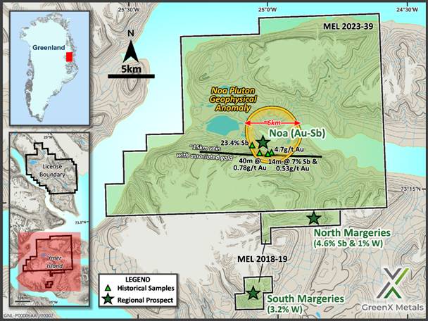
Figure 1: Overview of gold and critical metal prospects within Eleonore North.
NOA PROSPECT- POTENTIALLY LARGE-SCALE BULK TONNAGE GOLD/ANTIMONY
The Noa Prospect is located within the ELN Project on exploration licence MEL 2023-39 and has the potential to host a "reduced intrusion-related gold system" (RIRGS), analogous to large bulk-tonnage deposit types found in Canada including Donlin Creek, Fort Knox and Dublin Gulch.
· Gold and antimony mineralisation documented at the high-priority Noa Prospect within Eleonore North2
· Geophysical "bullseye" anomaly 6 km wide co-incident with elevated gold and antimony mineralisation from historical geochemical sampling2
· Anomalous gold mineralisation associated with quartz veining exposed at surface over a length of up to 15 km1.
· Historical individual specimens grading up to 23% antimony (Sb), and other samples up to 4g/t gold (Au)1
· Previously reported historical data confirmed the presence of gold and high-grade antimony in outcropping veins at ELN including:
o 14 m long chip sample grading 7.2% Sb and 0.53g/t Au2
o 40 m chip line with a length weighed average of 0.78g/t Au2
· Antimony mineralisation has been identified along a ~4km trend in veins and structures, that broadly aligns with previously identified gold veining at surface within a 15 km trend1.
Eleonore North hosts antimony- and gold-bearing veins in an area sitting above a geophysical anomaly at Noa interpreted to be a pluton (Figure 2). A passive seismic survey in 2023 showed evidence for multiple blind intrusions rising to just beneath the surface3. Geological features such as the metal association and mineralisation style provide additional evidence for a RIRGS being active at the Noa prospect.
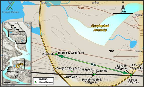
Figure 2: Historical results show evidence for high-grade antimony and gold mineralisation above the interpreted pluton at Noa.
Previous exploration was focused on orogenic gold mineralisation meaning that RIRGS targets have been overlooked. GreenX believes that the antimony-gold mineralisation above the pluton at Noa could be analogous to Perpetua Resources' Stibnite Gold Project in Idaho, USA. There, RIRGS and orogenic gold mineralisation styles overprint each other.
During the 2023 field season, a passive seismic survey was undertaken above the pluton at Noa within ELN. Processing the results in 3D identified multiple blind plutons within the survey area. These 1 to 2 km-wide elongated plutons make ideal hosts for RIRGS mineralisation and are priority targets.
MARGERIES PROSPECTS - HIGH GRADE TUNGSTEN & ANTIMONY HISTORICAL ESTIMATE
The Margeries Prospects also are located within the ELN Project on exploration licence MEL 2018-19, where high-grade tungsten mineralisation and antimony mineralisation has been identified as follows, as historical estimates:
· 83kt of mineralised rock with a mean grade of 4.6% Sb at North Margeries
· 58.1kt of mineralised rock grading at 3.2% W at South Margeries
· 32kt of mineralised rock grading at 1% W at North Margeries
· Cautionary statement: The Historical Estimates in this announcement are not reported in accordance with the JORC Code. A competent person has not done sufficient work to classify the Historical Estimate as a mineral resource or ore reserve in accordance with the JORC Code. It is uncertain that following evaluation and/or further exploration work that the Historical Estimate will be able to be reported as a mineral resource or ore reserve in accordance with the JORC Code.
· Over 2,000m of historical drilling completed with core still available in Greenland, as well as sighter metallurgical test work on the tungsten, both of which will be revisited and re-analysed by the Company's geologists to aim to conform with JORC requirements
· Both tungsten and antimony are on the USA and EU critical raw materials list, both experiencing dramatic price increases over the last year due to Chinese restriction of exports with both commodities critical to defence and the energy transition
· The mineralisation is hosted within a >10 km strike length underexplored sulphide bearing hydrothermal vein system and east to west fault systems
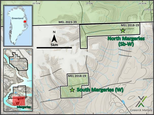
Figure 3: Location map for the Margeries Prospects within MEL 2018-19.
Both the North and South Margeries targets host Historical Estimates including tungsten (W). North Margeries additionally includes an antimony (Sb) Historical Estimate. North and South Margeries are both within 10 km of fjords allowing ready shipping access. The region is mountainous with locally ice-covered plateaus and deep U-shaped valleys.
Previous Tungsten-Antimony Exploration
The first commercial exploration in the area was carried out by Nordisk Mineselskab A/S (Nordisk) who began their initial investigations in the western part of Ymer Island in the 1950s. Nordisk was dissolved in 1991 and the permit covering the North and South Margeries prospects was taken over by NunaOil A/S (NunaOil) in 1992. NunaOil later became (NunaMinerals). NunaMinerals held the licence until 2016 when the company went into liquidation.
Based on the historical data that the Company has now reviewed, exploration work by Nordisk began on Ymer Island in the 1950s after galena-bearing veins had been identified in the Noa area (Harpøth, 1986). Pan samples collected in streams of western Ymer Island in the 1970s led to the discovery of North Margeries and South Margeries.
These targets were drilled in 1981 and 1983 by Nordisk with a total of 35 holes for 2,240m. Shallower holes were drilled in 1981 using a diamond drill rig, while in 1983 deeper, percussion holes were drilled. In 1992, NunaOil took 137 stream samples. Between 2008 and 2014, NunaMinerals flew heliborne magnetics and electromagnetics surveys over Noa and Margeries valleys. The Company will revisit and re-analyse the historic drilling data with an aim to report it in accordance with the JORC Code.
Historic Metallurgical Test Work
Scoping level metallurgical test work by SGS Mineral Services UK in 2012 on a bulk sample from South Margeries has been obtained by the Company.
GreenX's technical team will continue to review and verify the historical metallurgical test work, whilst assessing the opportunity to take samples from historic core for modern day mineralogical analysis and to obtain additional bulk samples for both tungsten and antimony metallurgical sighter test work, with an aim to be reported in accordance with the JORC Code.
Historical Estimate
In 1984, a Historical Estimate was prepared by Nordisk for North and South Margeries using the data collected during the drilling programs of 1981 and 1983.
At South Margeries, the mean value of the Historical Estimate is 58.1kt of mineralised rock grading at 3.2% W. At North Margeries, the Historical Estimate is 83kt of antimony-mineralised rock with a mean grade of 4.6% Sb and 32kt of tungsten-mineralised rock grading at 1% W.
The Historical Estimates were calculated by Nordisk using the original data collected by the same company.
No modern resource estimation compliant with current industry reporting codes such as JORC has been undertaken in the project area.
Cautionary statement: The Historical Estimates in this announcement are not reported in accordance with the JORC Code. A competent person has not done sufficient work to classify the Historical Estimate as a mineral resources or ore reserves in accordance with the JORC Code. It is uncertain that following evaluation and/or further exploration work that the Historical Estimate will be able to be reported as a mineral resources or ore reserves in accordance with the JORC Code.
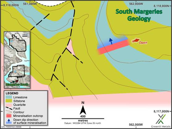
Figure 4: Geological map for the South Margeries target within MEL 2018-19. The mineralisation is open to the east and dips to the north.
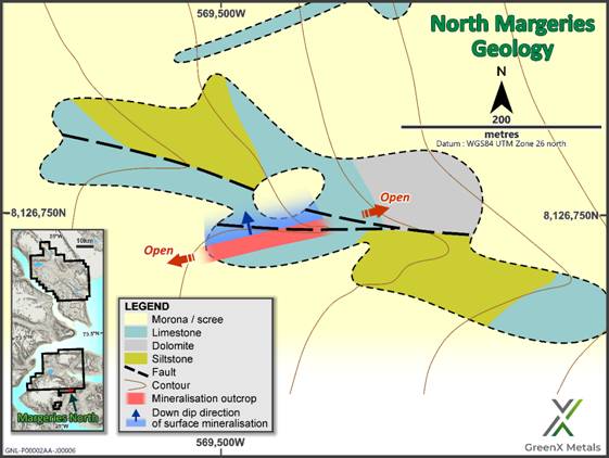
Figure 5: Geological map for the North Margeries target within MEL 2018-19. The mineralisation is open along strike and dips to the north.
Critical Raw Materials
Both tungsten and antimony are on the USA and EU critical raw materials lists, with both recently experiencing dramatic supply constraints due to China announcing restriction of exports between late 2023 and February 2025, with both commodities being critical to defence, the energy transition and other industries.
ANTIMONY: Global strategic interest in antimony has significantly increased over the last 18 months due to several factors:
o China controls ~50% of global antimony mining, most downstream processing and 32% of global resources according to the Lowy Institute.
o China's previously announced export ban on antimony has caused market disruption.
o Antimony is a crucial material in the defence supply chain, used in various military applications including ammunition, flame retardants, and smart weaponry.
o Antimony is essential in renewable energy technologies including more-energy-efficient solar panel glass containing and in preventing thermal runaway in batteries.
The antimony price has now climbed to US$60,000/t from historical prices of ~US$5,000 - 10,000/t. The strategic importance of antimony is such that during 2025 the US government has facilitated development of an investment in US antimony assets. In September 2025, the DLA awarded U.S. Antimony Corp an exclusive, sole-source contract for up to US$245 million to supply antimony metal ingots for the national defence stockpile.
In January 2025, the US government issued final permitting for Perpetua Resources' Stibnite gold/ antimony project in Idaho. The Pentagon has committed nearly US$60 million to the project through the Defence Production Act. In October 2025 JPMorgan Chase (JP Morgan) announced that it will invest $75 million of its own funds for a ~3% stake in Perpetua from its recently announced $1.5 trillion investment fund for U.S. national security, a move underscoring the Perpetua's key role in producing a metal which is used to make bullets and other weaponry.
TUNGSTEN: Global strategic interest in tungsten significantly increased in February 2025 when China announced sweeping export controls targeting tungsten and four other metals used across defence, clean energy and other industries. China's export controls were announced minutes after an additional 10% tariff on Chinese goods imposed by U.S. President Donald Trump came into effect.
About 90% of global tungsten comes from Russia, China and North Korea, with China alone accounting for about 80 per cent of the world's tungsten output. The US has not had domestic tungsten production since 2015.
Geology
The Project is centred around the >10 km thick, unmetamorphosed Late Precambrian Eleonore Bay Group (EBG) sedimentary package. Replacement type tungsten-antimony-gold mineralisation is hosted within wide sulphide-bearing hydrothermal veins and east to west fault systems (>10 km in length) which cuts sandstones, siltstones and shales of the Quartzitic Series of the EBG at Noa. The multicoloured series of the EBG (limestone, dolomite and dolomitic shale) hosts separate, high grade lenses of scheelite (tungsten) and stibnite (antimony) mineralisation at South Margeries and North Margeries, respectively.
The tungsten and antimony mineralisation in the Margeries Prospects occurs in silicified lensoid breccia zones in the central portions of graben like fault structures associated with E-W faults. The very high grades of tungsten and antimony and their restriction to discrete strata within the EBG is inferred to result from chemical traps offered by the availability of calcium within limestones and dolomites (scheelite mineralisation) and similarly the high concentrations of sulphur within the dolomite-shales (stibnite mineralisation). The vertical expression of the hydrothermally zoned mineralised system is upwards of 1,500 metres.
Exploration Potential
In 2008, NunaMinerals commissioned SkyTEM to conduct a helicopter-borne combined time domain electromagnetic (EM) and magnetic geophysical survey, comprising of 2,250 line kilometres. This resulted in the delineation of several significant geophysical targets within the area, many of which may correspond to known geochemical sediment anomalies. Hyperspectral surveying by NunaMinerals could potentially identify a unique spectral signature occurring with the structures hosting further mineralisation. This could be an important dataset for delineating the strike continuity of existing targets and the potential identification of additional mineralisation within the region (although no forecast is made of whether that may occur).
GreenX has acquired the historical hyperspectral data from the Danish and Greenlandic Geological Survey (GEUS) in Copenhagen and will appoint a geophysics contractor to process the data.
Drill core from the Historical Estimate at the Margeries Prospects exists in government archives and is available for inspection and sampling.
NEXT STEPS FOR THE ELEONORE NORTH PROJECT
Noa Prospect:
· Process the historical hyperspectral survey;
· Field mapping and sampling to ground-truth RIRGS targets and identify drill targets.
Margeries Prospects:
· Collect bulk sample material for both tungsten and antimony metallurgical sighter test work;
· Inspect the archive core with a view to obtaining samples for re-analysis and metallurgical sighter test work.
· Reprocessing of historic geophysics / hyperspectral data and field mapping to identify drill targets.
ELN COMMERCIAL TERMS
As announced on 15 July 2024 regarding the revised commercial terms for GreenX to acquire the Eleonore North Project, a final payment of A$1,000,000 in cash or GreenX shares was required for GreenX to retain the ELN Project after 31 December 2025.
GreenX now intends to retain its interest in ELN and accordingly will issue A$1,000,000 in value of GreenX shares (subject to 12 months escrow and based on the 5 trading day VWAP to 1 January 2026) in due course, but no later than 31 January 2026.
ARCTIC RIFT COPPER PROJECT (ARC) AND JOINT VENTURE
Given the prospectivity and focus on the Tannenberg Copper Project in Germany and at Eleonore North, and following a review of its portfolio of projects and the most efficient and effective use of the Company's resources, GreenX has decided to withdraw from the ARC Joint Venture, which in accordance with the terms of the Earn-in and Joint Venture Agreement (JVA) between GreenX Metals Limited, its wholly owned subsidiary Mineral Investments Pty Ltd, and Greenfields Exploration Limited (GEX) dated 6 October 2021, will become effective in 90 days. As a result of the withdrawal from the JVA, the Company will recognise an impairment expense of A$7.77 million relating to the impairment of the exploration and evaluation asset previously recognised in relation to the ARC project.
ENQUIRIES
|
+44 207 478 3900 ir@greenxmetals.com |
Sapan Ghai Chief Commercial Officer - UK
|
|
Kim Eckhof Investor Relations - UK / Germany
|
Kazimierz Chojna Investor Relations - Poland
|
Competent Person Statement - Historical Estimate
The information in this announcement that relates to the Historical Estimates is based on information reviewed and compiled by Dr Matt Jackson, a Competent Person who is a member of the Australian Institute of Geoscientists. Dr Jackson is a consultant engaged by GreenX. Dr Jackson has sufficient experience that is relevant to the style of mineralisation and type of deposit under consideration and to the activity being undertaken, to qualify as a Competent Person as defined in the 2012 Edition of the 'Australasian Code for Reporting of Exploration Results, Mineral Resources and Ore Reserves'. Dr Jackson consents to the inclusion in this announcement of the matters based on his information in the form and context in which it appears. Dr Jackson confirms that the information in this announcement provided under ASX Listing Rules 5.12.2 to 5.12.7 is an accurate representation of the available data and studies relating to the Eleonore North Project.
Competent Person Statement - EXPLORATION RESULTS
The information in this report that relates to exploration results were extracted from the ASX announcements dated 10 July 2023, 15 July 2024 and 27 November 2024 which are available to view at www.greenxmetals.com.
GreenX confirms that (a) it is not aware of any new information or data that materially affects the information included in the original announcement; (b) all material assumptions and technical parameters underpinning the content in the relevant announcement continue to apply and have not materially changed; and (c) the form and context in which the Competent Person's findings are presented have not been materially modified from the original announcements.
Forward Looking Statements
This release may include forward-looking statements, which may be identified by words such as "expects", "anticipates", "believes", "projects", "plans", and similar expressions. These forward-looking statements are based on GreenX's expectations and beliefs concerning future events. Forward looking statements are necessarily subject to risks, uncertainties and other factors, many of which are outside the control of GreenX, which could cause actual results to differ materially from such statements. There can be no assurance that forward-looking statements will prove to be correct. GreenX makes no undertaking to subsequently update or revise the forward-looking statements made in this release, to reflect the circumstances or events after the date of that release.
This announcement has been authorised for release by Mr Ben Stoikovich, Director.
References and sources
Cook, M.R. (2012). Scoping level testing on a scheelite ore sample Nuna Minerals. SGS. Internal company report.
Harpøth, O. (1986). The Noa Dal antimony-gold vein on Ymers, central East Greenland. (Nordisk Mineselskab A/S, internal company report).
Pedersen, J.L. & Olesen B.L. (1984). Vein Type Tungsten and Antimony Mineralisation in Central East Greenland. (Nordisk Mineselskab A/S, internal company report). Historical Estimate Original Source Document
1 Previously reported - refer to announcement dated 27 November 2024
2 Previously reported - refer to announcement dated 10 July 2023
3 Previously reported - Refer to announcement dated 15 July 2024
SCHEDULE 1 - HISTORICAL ESTIMATE
Details of Non-JORC Historical Estimates in relation to ASX Listing Rule Chapter 5
Listing Rules 5.10 to 5.12: Requirements applicable to reports of Historical Estimates of mineralisation for material mining projects:
|
5.10 - An entity reporting historical estimates or foreign estimates of mineralisation in relation to a material mining project to the public is not required to comply with rule 5.6 (The JORC Code) provided the entity complies with rules 5.12, 5.13 and 5.14 |
For the Non-JORC Historical Estimate included in this market release, GreenX is not required to comply with Listing Rule 5.6 (JORC Code) as all relevant and requested disclosures are stated in this announcement and tabulated below. The Company complies with Listing Rule 5.12 requirements for the statement of Non-JORC Historical Estimates, as discussed below. |
|
5.11- An entity must not include historical estimates or foreign estimates (other than qualifying historical estimates) of mineralisation in an economic analysis (including a scoping study, preliminary feasibility study, or a feasibility study) of the entity's mineral resources and ore reserves holdings. |
GreenX is not applying any economic analysis or commentary to the Historical Estimate in this Announcement. The Historical Estimates should not be relied upon for any economic evaluation. |
|
5.12 - Subject to rule 5.13, an entity reporting historical estimates or historical estimates of mineralisation in relation to a material mining project must include all of the following information in a market announcement and give it to ASX for release to the market: |
|
|
5.12.1 - The source and date of the historical estimates or foreign estimates. |
In 1984 a Historical Estimate was estimated by Nordisk for North and South Margeries using the data collected during the drilling programs of 1981 and 1983. The original source document was entitled "Vein Type Tungsten and Antimony Mineralisation in Central East Pedersen" by Pedersen, J.L. & Olesen B.L. (1984). The original source document was discovered in the archives of the Geological Survey of Denmark and Greenland. Report File 20730.
|
|
5.12.2 - Whether the historical estimates or foreign estimates use categories of mineralisation other than those defined in Appendix 5A (JORC Code) and if so, an explanation of the differences. |
The Historical Estimate did not use categories of mineralisation. The practice of the reporting codes and categories in Greenland/Denmark was only introduced in the 1990's and common practice from the 2000's onwards. The Historical Estimate were made prior to the JORC Code reporting guidelines being formulated and do not conform to the requirements in the JORC Code. The Historical Estimates were referred to as "Ore Reserves". Both the terms "ore" and "reserve" are considered to be inappropriate in line with the JORC Code, as there has been insufficient consideration of modifying factors. |
|
5.12.3 - The relevance and materiality of the historical estimates or foreign estimates to the entity. |
The Historical Estimates at the Margeries Prospects are relevant and material to GreenX's ongoing exploration efforts at ELN, with the data to be used for future exploration work programs and efforts to be made by the Company to aim to evaluate the mineralisation in accordance with the JORC Code. Further, the Historical Estimate lies within the Eleonore North exploration licences and are relevant to understanding the extent of mineralisation and W and Sb grades present at the project. Following further exploration work, the Company plans to aim to prepare an exploration target (in accordance with the JORC Code), prepare for a future drill program and conduct metallurgical testwork to report results in accordance with the JORC Code |
|
5.12.4 - The reliability of the historical estimates or foreign estimates, including by reference to any of the criteria in Table 1 of Appendix 5A (JORC Code) which are relevant to understanding the reliability of the historical estimates or foreign estimates. |
The Historical Estimates are not reported in accordance with the JORC Code. A competent person has not completed sufficient work to classify the Historical Estimates as a Mineral Resource Estimate in accordance with JORC Code. The Historical Estimates were made prior to the JORC Code reporting guidelines being formulated and do not conform to the requirements in the JORC Code. The Historical Estimate was produced using robust and well qualified methods that were unusually advanced for the time. The source data used for the estimate was produced using carefully planned quality control and quality assurance processes. Where percussion drilling was used, holes were rejected from the estimate where sample recovery was not sufficient, showing an understanding of grouping and segregation error. Drilling recovery was near 100%. Sub sampling procedures were designed using Gy sampling theory, errors were calculated and adjusted to keep within acceptable limits. Custom-made standards were produced for the project to remove instrumentation bias. Also of note was that the project used an umpire lab to test for inter-lab bias. Also unusual for the time was the use of computing to store the data and to calculate the estimates. This shows an attempt to prevent transcription errors and use statistically valid estimation methodologies. The Company has completed a Table 1 of Appendix 5A (JORC Code) which are relevant to understanding the reliability of the Historical Estimates. Please refer below. GreenX is not treating the Historical Estimate as a Mineral Resource Estimate or Ore Reserve and considers the Historical Estimate to represent an exploration project that requires verification. However, nothing has come to the attention of the Company or the Competent Person that causes it to question the accuracy or reliability of the Historical Estimate and it is on this basis that the Company and Competent Person consider the Historical Estimate to be reliable. However, the Company and Competent Person has not independently validated the Historical Estimates and therefore is not to be regarded as reporting, adopting or endorsing the Historical Estimate. It is possible that following evaluation and/or further exploration work the currently reported Historical Estimate may materially change and at this point the Company will need to be update the reporting in accordance with the JORC Code (or it may never become reportable at all in accordance with the JORC Code). |
|
5.12.5 - To the extent known, a summary of the work programs on which the historical estimates or foreign estimates are based and a summary of the key assumptions, mining and processing parameters and methods used to prepare the historical estimates or foreign estimates. |
Refer to the "Previous Tungsten-Antimony Exploration" "Historic Metallurgical Test Work" and "Historical Estimate" sections of this Announcement. The Historical Estimate was based on 25 diamond drill-holes completed between 1981 and 1983 at the Margeries Prospects. The holes resulted in a total of 2,081 m of core with a diameter of 35.3 mm (129). Fourteen of the holes are at the South Margeries prospect, and eleven at the North Margeries prospect. The resulting assays were used to determine the Historical Estimate, with a polygonal method. The Company has not been able to verify the assays in accordance with the JORC Code and no exploration results are included in this announcement. |
|
5.12.6 - Any more recent estimates or data relevant to the reported mineralisation available to the entity. |
To the extent known to the Company, historical reports indicate no follow up drilling has occurred on the property since the Historical Estimate was made. Scoping level metallurgical test work completed by SGS Mineral Services UK in 2012 on a bulk sample from South Margeries has been obtained by the Company. GreenX's technical team will continue to review and verify the historical metallurgical test work, whilst assessing the opportunity to take samples from historic core for modern day mineralogical analysis and to obtain additional bulk samples for both tungsten and antimony metallurgical sighter test work, with an aim to be reported in accordance with the JORC Code. |
|
5.12.7 - The evaluation and/or exploration work that needs to be completed to verify the historical estimates or foreign estimates as mineral resources or ore reserves in accordance with Appendix 5A (JORC Code) |
The Company plans to take the following next steps to further seek to verify the Historical Estimate identified at the Margeries Prospects: · Further review and verification of historical data (to aim for it be reported in accordance with the JORC Code), including recently acquired historical hyperspectral data; · Conduct a site visit to Greenland to inspect the historic core with a view to obtaining samples for further mineralogical analysis; · Seek to prepare an exploration target (in accordance with the JORC Code) to support a future drill program; and · Take additional samples for both tungsten and antimony metallurgical sighter test work. Ther is no certainty that further exploration work will result in the Historical Estimate being reported in accordance with the JORC Code. |
|
5.12.8 - The proposed timing of any evaluation and/or exploration work that the entity intends to undertake and a comment on how the entity intends to fund that work. |
The Company expects to complete the next steps identified above in the following 12 months. GreenX recently reported cash reserves of approximately $3.7 million (30 September 2025 - unaudited). |
|
5.12.9 - A cautionary statement proximate to, and with equal prominence as, the reported historical estimates or foreign estimates stating that: the estimates are historical estimates or foreign estimates and are not reported in accordance with the JORC Code; a competent person has not done sufficient work to classify the historical estimates or foreign estimates as mineral resources or ore reserves in accordance with the JORC Code; and it is uncertain that following evaluation and/or further exploration work that the historical estimates or foreign estimates will be able to be reported as mineral resources or ore reserves in accordance with the JORC Code |
A cautionary statement, proximate to, and with equal prominence as, the reported Historical Estimates has been stated on pages 1, 4 and 5 of this announcement. |
|
5.12.10 - A statement by a named competent person or persons that the information in the market announcement provided under rules 5.12.2 to 5.12.7 is an accurate representation of the available data and studies for the material mining project. The statement must include the information referred to in rule 5.22(b) and (c). |
A statement by a named competent person is included on page 9 of this announcement. |
JORC Code, 2012 Edition - Table 1 Report
Section 1 Sampling Techniques and Data
(Criteria in this section apply to all succeeding sections.)
|
Criteria |
JORC Code explanation |
Commentary |
|
Sampling techniques |
Nature and quality of sampling (eg cut channels, random chips, or specific specialised industry standard measurement tools appropriate to the minerals under investigation, such as down hole gamma sondes, or handheld XRF instruments, etc). These examples should not be taken as limiting the broad meaning of sampling. |
Work comprised a total of 14 x 35mm or 52mm diameter diamond drill holes (1981 to 1983) At South Margeries a total of 24 diamond drill holes were completed. At North Margeries a systematic surface sampling using chip samples and percussion drilling was completed.
Chip samples were taken on 0.5 m-spaced profiles were carried out at South Margeries ; and percussion-drilled dust samples along the vein at North Margeries (0.5 m spacing along strike; holes to 1.5 m, collected in 0.5 m sections).
|
|
|
Include reference to measures taken to ensure sample representivity and the appropriate calibration of any measurement tools or systems used. |
Unknown. |
|
|
Aspects of the determination of mineralisation that are Material to the Public Report. In cases where 'industry standard' work has been done this would be relatively simple (eg 'reverse circulation drilling was used to obtain 1 m samples from which 3 kg was pulverised to produce a 30 g charge for fire assay'). In other cases more explanation may be required, such as where there is coarse gold that has inherent sampling problems. Unusual commodities or mineralisation types (eg submarine nodules) may warrant disclosure of detailed information. |
Work was not conducted to modern industry standards.
Sub-sampling workflow designed using a sampling nomogram graph; half-core (~0.75 kg mass) was crushed to a nominal size of 1 mm then split and pulverised to less than 0.1 mm then split to generate 40 g for assay. |
|
Drilling techniques |
Drill type (eg core, reverse circulation, open-hole hammer, rotary air blast, auger, Bangka, sonic, etc) and details (eg core diameter, triple or standard tube, depth of diamond tails, face-sampling bit or other type, whether core is oriented and if so, by what method, etc). |
Work was not conducted to modern industry standards. Diamond drilling, chip sampling and percussion drilling was used. Chip sampling and percussion drilling was carried out on a systematic grid and percussion samples were only taken where sample recovery was sufficient.
|
|
Drill sample recovery |
Method of recording and assessing core and chip sample recoveries and results assessed.
|
Work was not conducted to modern industry standards. Details of the method of drill core recovery are not available but was reported to be close to 100% at South Margeries.
|
|
|
Measures taken to maximise sample recovery and ensure representative nature of the samples. |
No information available. Except that it is noted that where percussion drilling was used and water or rock quality affected sample recovery, the hole was abandoned and not sampled. |
|
|
Whether a relationship exists between sample recovery and grade and whether sample bias may have occurred due to preferential loss/gain of fine/coarse material. |
No information available. |
|
Logging |
Whether core and chip samples have been geologically and geotechnically logged to a level of detail to support appropriate Mineral Resource estimation, mining studies and metallurgical studies. |
No complete logging data is available. Historic reports show computerised drilling profiles including logging codes. JORC Mineral Resource not reported. |
|
|
Whether logging is qualitative or quantitative in nature. Core (or costean, channel, etc) photography. |
Logging was believed to be qualitative. No core photographs available. |
|
|
The total length and percentage of the relevant intersections logged. |
Not known. |
|
Sub-sampling techniques and sample preparation |
If core, whether cut or sawn and whether quarter, half or all core taken. |
Samples from half core in 50 cm intervals |
|
If non-core, whether riffled, tube sampled, rotary split, etc and whether sampled wet or dry. |
Not reported |
|
|
For all sample types, the nature, quality and appropriateness of the sample preparation technique. |
Sub-sampling procedure designed using a sampling nomogram;. Steps: half-core (50 cm) crushed to −1 mm; split; one portion to −0.1 mm (ring mill); split to ~40 g for analysis. Relative subsampling error ~1% at 2.7% W
Sub-sampling workflow designed using Gy's "safe sampling" graph; half-core 50 cm (~0.75 kg) → −1 mm → split → −0.1 mm → ~40 g for assay. |
|
|
|
Quality control procedures adopted for all sub-sampling stages to maximise representivity of samples. |
Statistical accuracy was calculated frequently throughout sample preparation and minimised. Report frequently refers to Gy sampling theory. Sub-sampling relative error was reported to be ca 10% and as such more than acceptable for this program |
|
|
Measures taken to ensure that the sampling is representative of the in situ material collected, including for instance results for field duplicate/second-half sampling. |
No details of the frequency or type of duplicates is mentioned. It is implied from the calculation of sub-sampling error that crush and/or pulp duplicates were analysed. The original report includes discussion of inter-laboratory duplicates which shows a low level of error. |
|
|
Whether sample sizes are appropriate to the grain size of the material being sampled. |
Nominal sample sizes were reported to be 0.75Kg and believed to be suitable given the high concentrations of Sb and W being analysed. |
|
Quality of assay data and laboratory tests |
The nature, quality and appropriateness of the assaying and laboratory procedures used and whether the technique is considered partial or total. |
All samples are historical in nature and do not comply with modern QAQC protocols. |
|
|
For geophysical tools, spectrometers, handheld XRF instruments, etc, the parameters used in determining the analysis including instrument make and model, reading times, calibrations factors applied and their derivation, etc. |
N/A |
|
|
Nature of quality control procedures adopted (eg standards, blanks, duplicates, external laboratory checks) and whether acceptable levels of accuracy (ie lack of bias) and precision have been established. |
It is inferred that sub-sampling duplicates were used, but no mention of field duplicates is made in the original report. A total of three project specific artificial standards were made up and used for the program.
The report states that low levels of error were encountered, it is therefore unlikely that significant bias was present. |
|
Verification of sampling and assaying |
The verification of significant intersections by either independent or alternative company personnel.
|
N/A |
|
|
The use of twinned holes. |
No twinned holes reported |
|
|
Documentation of primary data, data entry procedures, data verification, data storage (physical and electronic) protocols. |
All data was stored in a computer data base and no details of verification protocols is available. |
|
|
Discuss any adjustment to assay data. |
No adjustments made. |
|
Location of data points |
Accuracy and quality of surveys used to locate drill holes (collar and down-hole surveys), trenches, mine workings and other locations used in Mineral Resource estimation. |
Location accuracy is unknown. But collar locations were lodged onto a local grid and z-values calculated from a topographic map. |
|
|
Specification of the grid system used. |
Project specific local grid. |
|
|
Quality and adequacy of topographic control. |
Not known |
|
Data spacing and distribution |
Data spacing for reporting of Exploration Results. |
Drilling was carried out on an approximate 25-50m grid. Although in some cases 2-3 holes fanned out from one collar.
Chip samples were taken on a systematic grid of channels. Each channel was spaced 0.5m from the next and samples were taken along 50m intervals.
Percussion dust sampling was carried out on 0.5m intervals along each outcrop. |
|
|
Whether the data spacing and distribution is sufficient to establish the degree of geological and grade continuity appropriate for the Mineral Resource and Ore Reserve estimation procedure(s) and classifications applied. |
Data spacing was sufficient for the purposes of this announcement. JORC Mineral Resources are not reported here. |
|
|
Whether sample compositing has been applied. |
N/A |
|
Orientation of data in relation to geological structure |
Whether the orientation of sampling achieves unbiased sampling of possible structures and the extent to which this is known, considering the deposit type. |
The orientation of the drilling was oblique to the mineralisation in some cases. This announcement does not provide individual intercepts and only historical resource information. |
|
|
If the relationship between the drilling orientation and the orientation of key mineralised structures is considered to have introduced a sampling bias, this should be assessed and reported if material. |
Drill core recovery was near 100%, so no sampling bias is possible. Percussion drilling was abandoned where sample recovery was not considered sufficient. So all possible steps to remove bias have been taken. |
|
Sample security |
The measures taken to ensure sample security. |
Not known. |
|
Audits or reviews |
The results of any audits or reviews of sampling techniques and data. |
Not known. |
Section 2 Reporting of Exploration Results
(Criteria in the preceding section also apply to this section.)
|
Criteria |
JORC Code explanation |
Commentary |
|
|
Mineral tenement and land tenure status |
Type, reference name/number, location and ownership including agreements or material issues with third parties such as joint ventures, partnerships, overriding royalties, native title interests, historical sites, wilderness or national park and environmental settings. |
The Eleonore North Project is a result of a scientific and systematic reduction of Greenfield Exploration's (GEX) 'Frontier' Project. Eleonore North comprises two Exploration Licences (MEL2023-39 and MEL 2018-19). The combined spatial area of licences is 1,220.81 km2. The boundaries of Eleonore North Project are defined by the points:
MEL2023-39 (two polygons: 1,189.77 km2) 73.98333 °N 25.30000 °W 73.98333 °N 25.13333 °W 73.95000 °N 25.13333 °W 73.95000 °N 25.01667 °W 73.91667 °N 25.01667 °W 73.91667 °N 24.86667 °W 73.88333 °N 24.86667 °W 73.88333 °N 24.51667 °W 73.86667 °N 24.51667 °W 73.86667 °N 24.48333 °W 73.85000 °N 24.48333 °W 73.85000 °N 24.43333 °W 73.70000 °N 24.43333 °W 73.70000 °N 24.48333 °W 73.68333 °N 24.48333 °W 73.68333 °N 25.01667 °W 73.70000 °N 25.01667 °W 73.70000 °N 25.05000 °W 73.71667 °N 25.05000 °W 73.71667 °N 25.08333 °W 73.73333 °N 25.08333 °W 73.73333 °N 25.21667 °W 73.75000 °N 25.21667 °W 73.75000 °N 25.26667 °W 73.76667 °N 25.26667 °W 73.76667 °N 25.33333 °W 73.78333 °N 25.33333 °W 73.78333 °N 25.38333 °W 73.80000 °N 25.38333 °W 73.80000 °N 25.48333 °W 73.91667 °N 25.48333 °W 73.91667 °N 25.25000 °W 73.95000 °N 25.25000 °W 73.95000 °N 25.30000 °W
73.41667 °N 25.31667 °W 73.41667 °N 25.03333 °W 73.43333 °N 25.03333 °W 73.43333 °N 24.60000 °W 73.23333 °N 24.60000 °W 73.23333 °N 25.60000 °W 73.26667 °N 25.60000 °W 73.26667 °N 25.53333 °W 73.30000 °N 25.53333 °W 73.30000 °N 25.45000 °W 73.31667 °N 25.45000 °W 73.31667 °N 25.31667 °W
MEL 2018-19 (two polygons: 31.04 km2) 73.16667 °N 25.11667 °W 73.16667 °N 25.01667 °W 73.15000 °N 25.01667 °W 73.15000 °N 25.05000 °W 73.13333 °N 25.05000 °W 73.13333 °N 25.15000 °W 73.15000 °N 25.15000 °W 73.15000 °N 25.11667 °W
73.23333 °N 25.05000 °W 73.23333 °N 24.76667 °W 73.21667 °N 24.76667 °W 73.21667 °N 25.01667 °W 73.20000 °N 25.01667 °W 73.20000 °N 25.05000 °W The licences are currently in credit due to previous expenditure. Expenditure above the minimum regulatory requirement is carried forward for a maximum of three years. Eleonore North is in good standing and GreenX owns 100% of the licences following conclusion of a revised option agreement as announced on 15 July 2024..
GreenX will issue a 1.5% NSR for Eleonore North. |
|
|
|
The security of the tenure held at the time of reporting along with any known impediments to obtaining a licence to operate in the area. |
The licences are in good standing. |
|
|
Exploration done by other parties |
Acknowledgment and appraisal of exploration by other parties. |
1953 - lead, copper and zinc bearing veins were discovered at Noa as part of a regional mapping program by Nordisk Mineselskab A/G ('Nordisk').
1974 - 1976: Nordisk mapped the Holmesø copper-antimony prospect in Brogetdal, Strindbergland. Geophysical surveying was performed. The outcropping mineralisation was blasted a 100kg bulk sample was retrieved, of which 35kg was sent for analysis. Finally, an attempt was made to drill the mineralisation, and only the top 1.4m of a targeted 17m mineralised horizon was sampled before the rig broke down. Nordisk concluded that the Holmesø mineralisation is epigenetic.
1981 - 1983: Nordisk discovered the two small, high-grade tungsten and antimony-tungsten deposits on Ymer Island. These are respectively known as South Margeries and North Margeries . These deposits were drilled and Historical Estimates were made. Economic studies were performed but concluded that more mineralised material was needed. The drilled mineralisation is open at depth and along strike. The historical work on the tungsten and antimony is not material to the understanding of the project's gold potential.
1984 - 1986: As part of Nordisk's search for more tungsten mineralisation, a large gold bearing vein was discovered in the southern cliff face of the valley at Noa. The mineralisation in the scree was sampled. Geochemical sampling was also performed which identified a 10 to 15 km long multielement anomaly dominated by arsenic and antimony, which have a positive correlation with gold. Nordisk had a strategic shift towards petroleum exploration after this point in time.
1992: With the demise of Nordisk in 1991, the Greenland state owned enterprise, NunaOil A/S in collaboration with Australia's Pasminco Ltd did additional sampling of the Noa gold veins. The program was successful in finding additional veins in the valley floor and extending the known mineralisation. However, the corporate mandate was for 'high grade gold' which it was unsuccessful in locating. This result is unsurprising given that the veins are above the hornfels and correspondingly yield high-grade antimony and low-gold content. GEX expects the gold content to increase, and antimony to decrease at depth towards the causative pluton.
2008 - 2009: GEUS visited Ymer Island and took various rock grab samples in the Noa area. Assay results from these samples were recently made publicly available on the Greenland Portal.
2009: NunaMinerals A/S, a public-private spinout from NunaOil A/S, conducted a heliborne magnetic survey over Margeries and Noa. The purpose of this survey was to directly detect tungsten, and antimony deposits. Neither of the known deposits were detectable using this method, however a distinct circular magnetic feature was identified in Noa. This magnetic feature was interpreted to be a granitic/intermediate intrusion. During this time, samples from the South Margeries deposit were sent for metallurgical analysis, which determined that the material was potentially suited to direct-shipping-ore, and amendable to basic beneficiation methods.
2011: Avannaa Resources Ltd ('Avannaa') conducted a basin-wide helicopter supported reconnaissance program. This included visits to the Holmesø mineralisation. Avannaa concluded that the Holmesø mineralisation was epigenetic and likely related to the mineralisation observed on Ymer Island.
2018-2019: Independence Group Ltd (subsequently rebranded as IGO Ltd ('IGO') through a joint-venture agreement with GEX, conducted field programs that were focussed on the sedimentary-hosted copper deposit model. During this time, IGO managed all geological aspects of the program while GEX managed the logistics in 2018 and 2019. IGO visited Noa in 2018 and 2019 but focussed on the north slope away from the pluton at Noa, and on areas typified by magnetic highs rather than the lows which define the pluton's circular magnetic signature. Despite this, quartzite mineralisation reminiscent of Holmesø was identified but no mineralogy is recorded in the documentation. While in the field with IGO in 2019, GEX alerted IGO to the presence of antimony and gold in the south side of the valley, but no commensurate sampling was performed. During the IGO earn-in period, GEX located the historical drillhole collars at North and South Margeries tungsten/antimony deposits.
The Holmesø prospect was visited by IGO in 2018, 2019 and 2022. IGO's Holmesø sampling did not replicate Nordisk's high-grade blast/bulk sample, or the drill results. Regional sampling identified diagenetic copper, as well as remobilised epigentic copper that expresses as course blebs of chalcocite within porous, bed-cutting, vuggy conduits.
2022: IGO conducted a structural and geochemical sampling program in Strindbergland (no activity on Ymer Island). This program correctly concluded that the 'sediment-hosted copper deposit model' is not a suitable analogy. IGO returned to GEX the licences that were in good standing, with the indebted licences being relinquished by IGO. The remaining licences became the 'Eleonore North' project, which is a subset of the original 'Frontier' project area.
2023: In May, GEX installed an array of passive seismic nodes on Ymer Island within the licence area. Passive seismic nodes record ambient noise in the crust and accumulate data over many weeks. In September 2023, GEX collected the nodes from Ymer Island. The nodes were returned to the Institute of Mine Seismology (IMS) for data download and processing. IMS produced a 3D velocity model. |
|
|
Geology |
Deposit type, geological setting and style of mineralisation. |
The vein-type tungsten and antimony mineralisation occurs in late Precambrian sedimentary rocks of the Eleonore Bay Group in Central East Greenland, particularly within the Multicoloured Series. These unmetamorphosed sandstones, siltstones, and limestones form part of a folded and faulted basin sequence that was later deformed during Caledonian deformation. The mineralisation is structurally controlled, occurring along steep, fault-related veins and fracture zones that acted as conduits for hydrothermal fluids. The mineral assemblage is dominated by scheelite and stibnite, with minor sulphides and quartz, and is commonly associated with silicification and carbonate alteration of the host rocks. |
|
|
Drill hole Information |
A summary of all information material to the understanding of the exploration results including a tabulation of the following information for all Material drill holes: easting and northing of the drill hole collar elevation or RL (Reduced Level - elevation above sea level in metres) of the drill hole collar dip and azimuth of the hole down hole length and interception depth hole length. |
No new exploration drilling results are being reported. |
|
|
|
If the exclusion of this information is justified on the basis that the information is not Material and this exclusion does not detract from the understanding of the report, the Competent Person should clearly explain why this is the case. |
No new exploration drilling results are being reported. |
|
|
Data aggregation methods |
In reporting Exploration Results, weighting averaging techniques, maximum and/or minimum grade truncations (eg cutting of high grades) and cut-off grades are usually Material and should be stated. |
No new exploration drilling results are being reported. |
|
|
|
Where aggregate intercepts incorporate short lengths of high grade results and longer lengths of low grade results, the procedure used for such aggregation should be stated and some typical examples of such aggregations should be shown in detail. |
No new exploration drilling results are being reported. |
|
|
|
The assumptions used for any reporting of metal equivalent values should be clearly stated. |
N/A. |
|
|
Relationship between mineralisation widths and intercept lengths |
These relationships are particularly important in the reporting of Exploration Results. If the geometry of the mineralisation with respect to the drill hole angle is known, its nature should be reported. |
No new exploration drilling results are being reported. |
|
|
|
If it is not known and only the down hole lengths are reported, there should be a clear statement to this effect (eg 'down hole length, true width not known'). |
No new exploration drilling results are being reported. |
|
|
Diagrams |
Appropriate maps and sections (with scales) and tabulations of intercepts should be included for any significant discovery being reported These should include, but not be limited to a plan view of drill hole collar locations and appropriate sectional views. |
Appropriate maps and tables are included in the main body of this announcement. Please also refer to diagrams included in announcements dated 10 July 2023, 15 July 2024 and 24 November 2024. |
|
|
Balanced reporting |
Where comprehensive reporting of all Exploration Results is not practicable, representative reporting of both low and high grades and/or widths should be practiced to avoid misleading reporting of Exploration Results. |
N/A. No new exploration drilling results are being reported. |
|
|
Other substantive exploration data |
Other exploration data, if meaningful and material, should be reported including (but not limited to): geological observations; geophysical survey results; geochemical survey results; bulk samples - size and method of treatment; metallurgical test results; bulk density, groundwater, geotechnical and rock characteristics; potential deleterious or contaminating substances. |
All substantive results are reported. Geological logs and downhole gamma logs are not reported here. |
|
|
Further work |
The nature and scale of planned further work (eg tests for lateral extensions or depth extensions or large-scale step-out drilling). |
Included in main body of announcement. |
|
|
|
Diagrams clearly highlighting the areas of possible extensions, including the main geological interpretations and future drilling areas, provided this information is not commercially sensitive. |
These diagrams are included in the main body of this release. Please also refer to diagrams included in announcements dated 10 July 2023, 15 July 2024 and 24 November 2024. |
|
Section 3 Estimation and Reporting of Mineral Resources
Given the Company is reporting non-JORC Historical Estimates, further exploration and evaluation activities are required to be completed to aim to verify the Historical Estimates as mineral resources in accordance the JORC Code. Accordingly, the Company cannot complete the Section 3 Estimation and Reporting of Mineral Resources JORC table unless and until a mineral resource estimate can be verified and estimated. There is no certainty that further exploration work will result in the Historical Estimate being reported in accordance with the JORC Code.
RNS may use your IP address to confirm compliance with the terms and conditions, to analyse how you engage with the information contained in this communication, and to share such analysis on an anonymised basis with others as part of our commercial services. For further information about how RNS and the London Stock Exchange use the personal data you provide us, please see our Privacy Policy.

Latest directors dealings
- 1 day ago TotalEnergies SE
- 1 day ago Bango
- 1 day ago Zigup
- 1 day ago PureTech Health
- 1 day ago Peel Hunt Limited NPV