
Updated Mineral Reserve Estimate
Summary by AI BETAClose X


13 August 2026
First Tin PLC
("First Tin" or "the Company")
Updated Mineral Reserve Estimate
First Tin PLC, a tin development company focused on advancing low-capex projects in Australia and Germany, is pleased to announce that an updated Ore Reserve Statement ("ORS") for its 100% owned Taronga Tin Project ("Taronga") in New South Wales, Australia has increased the project's Proved and Probable Ore Reserves by 13%.
The updated ORS has been prepared by Australian Mine Design and Development Pty Ltd ("AMDAD").
Highlights:
· Proved and Probable Ore Reserves increased by 5Mt (13%) to 45Mt @ 0.12% Sn containing approximately 55,000 tonnes of tin, from 40Mt @ 0.13% Sn containing 52,000 tonnes of tin.
· Proved Ore Reserves increased by 5Mt (19%) from 26Mt @ 0.14% Sn (36,000 t tin) to 31Mt @ 0.13% Sn (41,000 t tin), primarily reflecting the increase in Measured Resources reported in the updated MRE announced on 30 April 2026.
· The updated ore Reserves are contained entirely within the existing pit limits that form the basis of the current permitting process and add approximately one year to the current mine life.
· The strip ratio decreases from 1.02:1 to 0.79:1, due to conversion of previously classified waste material to ore within the current pit design.
· Preliminary pit optimisations using the recently updated MRE suggest potential for approximately 20Mt of additional mill feed and approximately four years of additional mine life under an optimised scenario based solely on Measured and Indicated Resources, subject to detailed pit designs, scheduling studies and permitting.
· The preliminary optimisation indicates that the pit could extend approximately 25-50 metres deeper than the current DFS pit design.
· Further upside is indicated when Inferred Resources are included in the optimisation.
Updated Ore Reserve Estimate:
The updated Proved and Probable Ore Reserve Estimate ("ORE"), summarised in Table 1, is based on open-cut mining, feeding a 5Mtpa processing plant at Taronga. The ORE uses the updated 2026 resource model reported by the Company on 30 April 2026.
Table 1 Taronga 2026 Ore Reserves
|
Category and Area |
Million Tonnes |
%Sn |
kt Sn |
|
Proved Reserves |
|
|
|
|
North Pit |
23 |
0.13 |
31 |
|
South Pit |
8 |
0.14 |
11 |
|
Total Proved Reserves |
31 |
0.13 |
41 |
|
Probable Ore Reserves |
|
|
|
|
North Pit |
8 |
0.09 |
8 |
|
South Pit |
6 |
0.11 |
6 |
|
Total Probable Reserves |
14 |
0.10 |
14 |
|
Proved and Probable Reserves |
|
|
|
|
North Pit |
31 |
0.12 |
38 |
|
South Pit |
13 |
0.13 |
17 |
|
Total Proved and Probable Reserves |
45 |
0.12 |
55 |
Notes:
The tonnes and grades shown are stated to a number of significant figures reflecting the confidence of the estimate. The table may nevertheless show apparent inconsistencies between the sum of components and the corresponding rounded totals.
The updated Ore Reserves are restricted to the existing pit limits being assessed through the permitting process. The increase in Ore Reserves therefore represents conversion of additional resources within the existing mine plan rather than an expansion of the current pit envelope being permitted.
The increase in Proved Reserves is particularly significant, with Proved Reserves increasing from 26Mt at 0.14% Sn, containing approximately 36,000 tonnes of tin, to 31Mt at 0.13% Sn, containing approximately 41,000 tonnes of tin. This increase primarily reflects the conversion of additional Measured Resources following the updated MRE.
Pit Optimisations for Potential Mine Life Extension:
The current Taronga mine plan is based on the 2024 DFS open-cut design and an earlier Mineral Resource model. Since that study, the Company has reported a materially larger MRE, together with updated assumptions relating to tin price and processing recovery.
To assess the potential impact of these changes, AMDAD has undertaken preliminary pit optimisation using the updated MRE, revised geological modelling and current project assumptions to generate a series of optimised pit shells. The optimisation considered a number of scenarios based on different combinations of cash flow or discounted cash flow ("DCF") optimisation and Measured and Indicated Resources ("MI") or Measured, Indicated and Inferred Resources ("MII"). Four different scenarios were modelled:
1. Maximum Cashflow Pit - Measured and Indicated Resources only
2. Maximum Cashflow Pit - Measured, Indicated and Inferred Resources
3. Maximum DCF Pit - Measured and Indicated Resources only
4. Maximum DCF Pit - Measured, Indicated and Inferred Resources
The results shown in Table 2 indicate significant potential to increase the volume of ore available for processing and extend the operating life of Taronga.
|
Scenario |
1. Max CF MI |
2. Max CF MII |
3. Max DCF MI |
4. Max DCF MII |
|
Mill feed (Mt) |
76.3 |
101.4 |
67.7 |
74.2 |
|
Waste Mined (Mt) |
87.2 |
108.6 |
64.8 |
62.0 |
|
Strip Ratio |
1.14 |
1.07 |
0.96 |
0.84 |
|
Grade Mined (% Sn) |
0.11 |
0.10 |
0.11 |
0.11 |
|
Tin Mined (kt) |
84 |
102 |
76 |
80 |
|
Recovery (%) |
56.6 |
56.3 |
57.0 |
57.0 |
|
Tin Sold (kt) |
48 |
58 |
43 |
46 |
|
Total Mine Life (yrs) |
15.3 |
20.3 |
13.5 |
14.8 |
Table 2: Taronga Pit Optimisation Scenarios
Under Scenario 3, the maximum DCF scenario based solely on Measured and Indicated Resources, the preliminary optimisation indicates approximately 68Mt of mill feed at 0.11% Sn, compared with approximately 48Mt of mill feed in the current pit design above the marginal economic cutoff. This represents potential additional mill feed of approximately 20Mt and an increase in the potential production life of approximately four years to 13.5 years. The corresponding optimised pit extends approximately 25-50 metres deeper than the current DFS pit design.
Scenario 4, a maximum DCF scenario incorporating Inferred Resources indicates potential for approximately 74Mt of mill feed at 0.11% Sn, highlighting additional upside beyond the M&I case. However, Inferred Resources have a low level of geological confidence.
The preliminary optimisation results are based on conceptual pit shells and do not constitute Ore Reserves. Further work is required, including detailed pit design, mine scheduling, geotechnical assessment, optimisation of mining rates and processing schedules, and the necessary permitting.
First Tin CEO, Bill Scotting, commented:
"This Ore Reserve update represents another important step forward for Taronga, increasing Proved and Probable Ore Reserves by 13% to 45 million tonnes and adding approximately one year to the current mine plan, all within the existing pit limits being assessed through the permitting process.
"Importantly, the updated Mineral Resource also provides a compelling opportunity to extend the mine beyond the current pit limits. Preliminary optimisation indicates the potential for approximately 20 million tonnes of additional mill feed and around four additional years of mine life using only Measured and Indicated Resources.
"This potential extension has yet to be converted into an Ore Reserve and will require detailed mine design, scheduling and permitting. Nevertheless, the combination of increased Ore Reserves, a lower strip ratio and the potential for a materially longer mine life provides further support for the development of Taronga. We look forward to incorporating this potential upside into the forthcoming optimised DFS."
Competent Person Statement
Information in this announcement that relates to Mineral Reserve estimation is based on information compiled by Mr Chris Desoe. Mr Desoe is a Fellow of the Australasian Institute of Mining and Metallurgy (AusIMM). Mr Desoe has sufficient experience relevant to the style of mineralisation and type of deposit under consideration, and to the activities undertaken, to qualify as a Competent Person as defined in the 2012 Edition of the Joint Ore Reserves Committee (JORC) Australasian Code for Reporting of Exploration Results, Mineral Resources and Ore Reserves. Mr Desoe is a director of Australian Mine Design and Development Pty Ltd and consents to the inclusion in this announcement of the matters based on this information in the form and context in which it appears.
Enquiries:
|
First Tin |
Via SEC Newgate below |
|
Bill Scotting - Chief Executive Officer
|
|
|
Arlington Group Asset Management Limited (Financial Advisor and Joint Broker) |
|
|
Simon Catt
|
+44 (0)20 7389 5016 |
|
Tamesis Partners LLP (Joint Broker) |
+44 (0) 20 3882 2868 |
|
Richard Greenfield / Charlie Bendon |
|
|
|
|
|
Zeus Capital Limited (Joint Broker) |
+44 (0)20 3829 5000 |
|
Harry Ansell / Dan Bristowe / Katy Mitchell
|
|
|
SEC Newgate (Financial Communications) |
|
|
Elisabeth Cowell / George Esmond / Gwen Samuel |
+44 (0)7540 106366 firsttin@secnewgate.co.uk |
Notes to Editors
First Tin PLC is an ethical, reliable, and sustainable tin production company led by a team of renowned tin specialists. The Company is focused on becoming a tin supplier in conflict-free, low political risk jurisdictions through the rapid development of high value, low capex tin assets in Germany and Australia, which have been de-risked significantly, with extensive work undertaken to date.
Tin is a critical metal, vital in any plan to decarbonise and electrify the world, yet Europe and North America have very little supply. Rising demand, together with shortages, is expected to lead tin to experience sustained deficit markets for the foreseeable future.
First Tin's goal is to use best-in-class environmental standards to bring two tin mines into production in three years, providing provenance of supply to support the current global clean energy and technological revolution.
JORC CODE 2012 EDITION TABLE 1 SECTION 4 - Estimation and Reporting of Ore Reserves
|
|
|
|
||||||||||||||||||||||||
|
Mineral Resource estimate for conversion to Ore Reserves |
· Description of the Mineral Resource estimate used as a basis for the conversion to an Ore Reserve. · Clear statement as to whether the Mineral Resources are reported additional to, or inclusive of, the Ore Reserves. |
· The Ore Reserve Estimate is based on the 2026 Resource Estimate prepared by H&S Consultants Pty Ltd (H&SC) for open cut resources at Taronga, reported by First Tin on 30 April 2026. The Mineral Resource estimate is reported at a 0.05% tin cutoff grade and is restricted to a nominal average depth of around 300m below surface (650mRL), which H&SC considered to be a reasonable depth for potential open pit mining. · The Mineral Resource estimate is inclusive of the Ore Reserve. · H&SC prepared the resource estimate using drill hole data from two phases of drilling:- o 1979-1982 drilling by Newmont primarily diamond drilling of 357 holes for 33,350m and o 2022-2025 drilling comprising a mix of diamond twin and geotechnical holes and Reverse Circulation (RC) exploratory drillholes completed by TMPL, which consisted of 156 holes for 13,807 m. · H&SC estimated in-situ tin grades by Ordinary Kriging (OK). Grade interpolation was unconstrained except by search parameters and the variography. · Regression equations based on newly available assay data were used to estimate missing copper, silver, arsenic and sulphur values. The arsenic and sulphur datasets are a lot smaller in number compared to the copper and silver data. Correlation between the various elements was modest to weak but generated regression equations using the Conditional Expectation technique that resulted in plausible outcomes. Copper and silver are reported as a separate Inferred Resource in conjunction with the tin estimates, whilst arsenic and sulphur are not reported as part of the Mineral Resources; these elements were modelled to allow for waste rock characterisation. · The modelled resource grades do not incorporate dilution. · Top cutting was not applied as extreme values were not considered to be significant by H&SC. · H&SC used the historic local N-S orthogonal grid for all interpretation and modelling work. AMDAD rotated and converted the block model to MGA94 Zone 56 using a Surpac two-point grid transformation script provided by H&SC. · Block dimensions are 5m by 10m by 5m (Local E, N, RL respectively) with no sub-blocking. The north dimension was chosen as it is around half to a third of the nominal drillhole distances in the detailed drilled area of the South Pit. The east dimension was chosen to take into account the geometry and thickness of the mineralisation in the South Pit. The vertical dimension was chosen to reflect the sample spacing and possible mining bench heights and to allow for flexibility in potential mining scenarios. · H&SC assigned dry bulk densities according to the oxidation zone, as listed below. o Oxide 2.6 t/m3 o Fresh 2.75 t/m3 · H&SC did not adjust the resource estimate for excavation of the bulk sample adits as it considers the volume and tonnage of the adit excavation negligible in the context of the accuracy of the resource estimates. · The estimated resources include Measured, Indicated and Inferred categories, classified in accordance with the 2012 JORC Code and Guidelines, and primarily based on the block search pass number derived from the grade interpolation. H&SC used five search passes with progressively larger search radii or decreasing data point criteria. Pass 1 used radii of 35m by 35m by 5m (along strike, down dip and across mineralisation respectively). Passes 2, 3 and 4 used 50m by 50m by 10m, 70m by 70m by 10m and 100m by 100m by 20m respectively. For Passes 1 to 4 the minimum number of data was 12, maximum number of data was 32, with a minimum of four octants. A fifth pass used a 100m by 100m by 20m search with a minimum of 6 data points from at least two octants. The maximum extrapolation for the Mineral Resources was in the order of 100m down dip and 100m along strike to the NE. The resources were categorised as follows:- o Measured: blocks estimated in Pass 1 o Indicated: blocks estimated in Pass 2 o Inferred: blocks estimated in Passes 3 to 5 · For the resource classification H&SC also considered the style of mineralisation, the geological model, validation of historical drilling, sampling methods and recoveries, non-sampled zones, the QAQC programme and results and comparison with the previous resource estimates. |
||||||||||||||||||||||||
|
Site visits |
· Comment on any site visits undertaken by the Competent Person and the outcome of those visits. · If no site visits have been undertaken indicate why this is the case. |
Chris Desoe, Competent Person for overall Ore Reserves sign-off, undertook a site visit at Taronga Project Site on 27th to 28th July 2022, including the following: · Geological sampling, including bulk sample adit · Open cut mining area, · Waste rock dump areas, · Potential run of mine (ROM) ore stockpile area, · Potential process plant facility and tailings dam areas, · Potential infrastructure areas, and · Access roads |
||||||||||||||||||||||||
|
Study status |
· The type and level of study undertaken to enable Mineral Resources to be converted to Ore Reserves. · The Code requires that a study to at least Pre-Feasibility Study level has been undertaken to convert Mineral Resources to Ore Reserves. Such studies will have been carried out and will have determined a mine plan that is technically achievable and economically viable, and that material Modifying Factors have been considered. |
· The Taronga Ore Reserve has been estimated in conjunction with preparation of a mine plan for the greenfield Taronga Tin Project Feasibility Study. · The overall project technical feasibility and economic viability is supported by a number of studies at Feasibility level, that are consolidated in the Taronga Tin Project Feasibility Study Update 2026 report, prepared by TMPL and Mincore in July 2026. That report covers all of the key elements of the project, addressing all material modifying factors for the mine plan and Ore Reserves estimate as described below. · The Taronga Tin Project Feasibility Study Update 2026 is preceded by:- o PFS prepared by Newmont Holdings Pty Ltd in 1982, o PFS prepared by AusTin Mining in 2014, and o Feasibility Study prepared by TMPL and Mincore in 2024. |
||||||||||||||||||||||||
|
Cut-off parameters |
· The basis of the cut-off grade(s) or quality parameters applied. |
· The Ore Reserve is defined by an elevated cutoff of 0.050% tin applied to the block model based on diluted tin grades. This cutoff grade, applied to enhance the cashflow profile and DCF, is approximately 16% higher than the average marginal economic cutoff of 0.043% that would maximise the undiscounted cash value of the open cut and the tonnage of economic ore and tin. · The marginal economic cutoff is based on the following assumptions:- o US$40,000/t tin price and exchange rate of $US0.70/AUD for AUD 57,143/t tin price o Variable processing recovery:- Recovery (%) = 8.1823 x loge(tin grade %Sn) + 73.855 o "Ore costs" of AUD9.81/t, including AUD 7.28/t processing cost, AUD 1.64/t general and administration, AUD 0.89/t mining fixed costs. o Tin selling cost of AUD 54.70/t
|
||||||||||||||||||||||||
|
Mining factors or assumptions |
· The method and assumptions used as reported in the Pre-Feasibility or Feasibility Study to convert the Mineral Resource to an Ore Reserve (i.e. either by application of appropriate factors by optimisation or by preliminary or detailed design). · The choice, nature and appropriateness of the selected mining method(s) and other mining parameters including associated design issues such as pre-strip, access, etc. · The assumptions made regarding geotechnical parameters (eg pit slopes, stope sizes, etc), grade control and pre-production drilling. · The major assumptions made and Mineral Resource model used for pit and stope optimisation (if appropriate). · The mining dilution factors used. · The mining recovery factors used. · Any minimum mining widths used. · The manner in which Inferred Mineral Resources are utilised in mining studies and the sensitivity of the outcome to their inclusion. · The infrastructure requirements of the selected mining methods. |
Mining Method Mining of the Taronga open cut pit will be by conventional drill and blast, load and haul methods. The development of the open cut will comprise excavation of two separate pits along a ridge line. The final North Pit will be approximately 190m deep from crest to base, 400m wide and 1.0km long at the pit crest. The final South Pit will be approximately 150m deep from crest to base, 380m wide and 1.3km long at the pit crest. Access to the pits will be via two-lane 25m wide haul road, supplemented by 14m wide single-lane haul roads for access to the uppermost benches and the pit base areas. Mining activities to be carried out on the Taronga Project site include; · Tree felling and vegetation clearing and grubbing from the footprints of the open cuts, waste rock emplacements, haul roads and pads, including stockpiling of limited topsoil · Development of haul roads and access roads · Mine water management including:- o dewatering of the pit o storage of run-off water and ground water within mine water storage dams, either for use for dust suppression, or for process water o management of surface rainwater runoff to keep uncontaminated water separate to contact water by use of water management structures including drains, bunds, sediment/containment ponds, piping and pumping · Grade control and probe drilling including:- o Drilling using the blasthole percussion drill rig but with angled holes, o Sampling and sample assaying o Adjustment of resource model as appropriate and mark out of ore zones o Probe drilling to ensure the bulk sample adits are located and the current conditions of the voids are clearly identified and assessed before mining operations commence in those particular areas · Implementation of measures to address the voids of the bulk sample adits to ensure safety in drill and blast operations. · Mining ore and waste rock from the open cut, by o Drill and blast mainly on 10m benches, with 5m benches for more selective ore mining where required, o Load and haul using 140t class primary hydraulic backhoe excavator, 90t secondary excavator, and 90t class rigid dump trucks. The shot 10m bench, approximately 12m high, will be dug in four flitches. · Management of waste rock including:- o Placement of waste rock on the Waste Rock Emplacements (WREs) and subsequent rehabilitation. o Internment of potentially acid forming (PAF) material within designated areas of the WRE and subsequent capping and rehabilitation. · Haulage of ore to the run of mine (ROM) crusher/stockpile area, where the ore will either be direct-tipped into the crusher or stockpiled for later rehandling and crushing. · Drilling and blasting operations will be undertaken by contractor. All other mining operations will be undertaken by TMPL. · Mine maintenance will be undertaken by TMPL. This will include the mining fleet as well as mine ancillary equipment and infrastructure such as roads, offices and workshops, car parking and hardstand areas, and water management structures. Geotechnical As part of the Taronga Tin Project Feasibility Study geotechnical specialist PSM undertook site visits and reviews. PSM provided slope designs for the open cuts as well as geotechnical assessment for the WRE and project infrastructure foundations. The open cut geotechnical design proposed by PSM is outlined below:- · Upper weathered zone (UWZ) and transitional zone (TZ):- 60° 10m high faces and 8m wide berms · Slightly weathered and fresh (SW-FR) rock:- o North Pit (all wall aspects) and South Pit with 291° to 139° aspect - 75° 20m high faces and 9m wide berms o South Pit with 140° to 290° aspect (facing south to southwest) - 65° 20m high faces and 8.5m wide berms
· Additionally PSM made the following recommendations and comments:- o A maximum inter-ramp height of 100m should be adopted. Haul ramps or a 20m wide geotechnical berm should be used to limit the inter-ramp height. o Pit slope management along with good blasting and excavation techniques will be critical to managing operational rockfall risk in the steep fresh rock pit slopes. o Pre-splitting is unlikely to be effective for the main wall aspects. However, pre-splitting should be effective in the end walls. o Surface and groundwater management is required, and a depressurisation program is recommended for the North Pit, such as installation of horizontal drain holes, to improve stability of the walls. o Walls forming saddles have an elevated risk of failure and designs in these areas will need geotechnical review. · Further work is required to address residual uncertainties in the following areas:- o Structure mapping and structural model o Pore pressure conditions o Weathering depths · A Ground Control Management Plan (GCMP) will be prepared as part of the implementation program. As well as addressing the above items, this will include pit wall inspections, wall scaling, slope displacement monitoring, and blasting trials to assess effectiveness of blast patterns and wall control techniques. Mine Design As part of the 2024 FS, the open cut design was guided by Whittle pit optimisation run by AMDAD. The optimisation, based on the 2023 MRE by H&SC, applied preliminary mining costs built up by AMDAD with input from TMPL, and other parameters provided by the Taronga Tin Project FS team. This included pit wall slopes based on the geotechnical design parameters by PSM with allowance for the haul ramps. The optimised pit shell that generated the highest DCF based on those preliminary 2024 FS assumptions was selected as a guide to prepare the practical open cut design. AMDAD prepared the 3D design using Surpac mine planning software. It has the following features: · Top of excavation: 970mRL North Pit, 940mRL South Pit · Base: 770mRL North Pit, 775mRL South Pit · Overall Strip Ratio: 1.0 t waste : 1.0 t ore · Haul Ramp o Width: 24m two lane, 14m single lane o Steepest Gradient: 1 in 9. · Approximate minimum mining width of 40m, and 25m at base of South Pit. Dilution and Mining Loss To update the mining block model AMDAD applied dilution adjustment block-by-block, based on the updated April 2026 MRE. The method simulates mixing at the grade-control boundaries resulting from blast movement, rilling of material down the faces of the working flitches, as well as imprecise excavation. Each block experiences an interchange of material across each lateral block face. Dilution grade is applied based on the grade of the adjacent material. The method adjusts tonnes and grade according to the nominated dilution skin thickness and block dimensions. The most conspicuous change in grades from the dilution method is at the ore-waste interface defined by cutoff grade. The ore blocks that abut the ore-waste interface decrease in grade after dilution. However, the waste blocks immediately on the other side of the boundary increase in grade and in some instances a new ore boundary results incorporating blocks that were previously waste. Within the ore zone a transfer of grade (metal) has occurred between blocks. In some instances, this has resulted in a slight increase of grade. In other cases, the grade has decreased slightly. Well within the ore zone, away from the ore boundary, the transfer of grade between blocks results in no net loss or gain of metal within the production tonnes, and the overall production grade remains the same. AMDAD applied a dilution skin of 1.0m for the North Pit, considered reasonable for mining by 130t class Caterpillar 6015 backhoe excavator or similar, with 2.4m wide bucket, and 10m high blast benches, and the geometry of the deposit, characterised by:- · Relatively continuous ore zones · near-vertical dip · Ore zones typically 10m wide to 50m wide in the South Pit and 80m wide to 150m wide in the North Pit For the South Pit, with narrower ore zones, TMPL nominated a dilution skin width of 0.5m based on a higher degree of selective mining. The dilution modelling results in an overall grade factor of 96.1% for the South Pit, 98.3% for the North Pit and 97.7% overall. The tonnes factors are 103.4%, 102.1% and 102.5% respectively for the South Pit, North Pit and overall. AMDAD applied additional adjustment of 1% dilution and 2% mining loss to account for minor but inevitable dilution and loss from bench haul road sheeting, movement of material from blasted upper benches down onto lower benches in the still-active starter pit, wall failures, as well as occasional mistakes and poor practice. Mine Sequencing and Schedule · Using the updated mining block model and the 2024 FS open cut stage design, AMDAD prepared a mining schedule using the Geovia MineSched program targeting a feed rate to the processing plant of 5Mtpa, with a nine month ramp-up period. · Prior to commencement of mining a nine month establishment phase will complete preparatory works including establishment of initial haul roads and access roads, water management structures, waste dump placement areas, initial open cut benches, and initial grade control drilling. · The open cut will be developed in 10m high benches, commencing at 970mRL bench at the North Pit. Two to three benches may be active at any time, accessed initially from a network of haul roads developed in the natural ground surface, then from ramps established in the pit walls as the pits are excavated below the crest lines. This will provide flexibility in work scheduling and help to balance resources. · Following the establishment phase, the operational schedule will see open cut mining conducted over a nine year LOM, with sustainable ore delivery after the first 6 months of production. Inferred Resources The Ore Reserve does not include Inferred Resources. However, approximately 1.0 Mt of Inferred Resources would be extracted within the proposed open cut design. This additional 2% of potential mill feed represents minor upside to the reserves. Topographic Surface Reserve and mining estimates are based on ground surface data in x, y, z text format provided in January 2023 by RW Corkery. RW Corkery prepared these data from 2022 LiDAR ground surface survey data from Measure Australia. Using the Surpac program, from the x, y, z data, AMDAD prepared a ground surface wireframe topo_rastert_combined.dtm. AMDAD used this ground surface model for its pit optimisation and mine design modelling. H&SC applied this ground surface model to its resource block model to assign values for the "topo" and "density_hsc" fields. Mine Water Management · Preliminary groundwater assessment by PSM indicated that groundwater levels in the North Pit range from 825 mRL to 880 mRL, which correlates to about 70 to 80 m below the current ground surface. Initial readings in the South Pit indicated potentially dry sensors to elevations of approximately 800 mRL to 825 mRL . Intersection of the groundwater table will likely occur from Year 7 H1 in the North Pit and from Year 8 H2 in the South Pit. Prior to this, mining will be carried out above the groundwater table. Initial groundwater assessment by Daniel Barclay, Hydrogeologist.com.au, indicates that significant inflows of groundwater into the Taronga open cuts are unlikely. Packer testing results from the geotechnical drilling indicates low hydraulic conductivity in the order of 0.01 m/day to 0.005 m/day. Even when the open cut benches are advanced below the water table, open cut dewatering requirements will be driven by rain and runoff events within the open cut crest, rather than groundwater inflow. · Open cut dewatering is planned to be managed by the following measures:- o Benches that "daylight" at the pit crest will be graded to drain to the crest and to external sumps dug near the crest. From here the water will be transferred by pipe, with pumping as required, to one or more centralised containment ponds. o in-pit sumps and high volume/high head diesel pumps will pump water to the external sumps or containment ponds. · Water management structures such as cutoff drains, bunds and culverts will be established to help prevent contaminated surface run-off from entering water courses beyond the mine area. They will be implemented in line with the site Surface Water Management Plan to be developed as part of the detailed design phase. Mine Infrastructure Mine infrastructure and services will include the following:- · Run of mine (ROM) Stockpile Area, including o Preference for ore to be direct tipped into the crusher hopper. o Otherwise ore will be placed on a buffer stockpile. o Removal of timber and trash from adits, trees. o Ore crushing. o The crushed ore will be transported to the processing plant by conveyor. · Mine Facilities Area, including o Mine workshop, equipment and tooling, welders, compressors, equipment stands, cranes o Diesel fuel storage and dispensing o lubricant storage and dispensing o mine warehouse o tyre change o equipment wash-down and parking areas · Mine office and facilities within the site admin/office area, including office furniture, computers, printers, servers and other IT related items, mine technical services equipment including survey equipment. · Lighting for night time mining operations · Water management structures, pumps and pipes as described under Mine Water Management above. · Storage of ammonium nitrate, explosives, explosives accessories. |
||||||||||||||||||||||||
|
Metallurgical factors or assumptions |
· The metallurgical process proposed and the appropriateness of that process to the style of mineralisation. · Whether the metallurgical process is well-tested technology or novel in nature. · The nature, amount and representativeness of metallurgical test work undertaken, the nature of the metallurgical domaining applied and the corresponding metallurgical recovery factors applied. · Any assumptions or allowances made for deleterious elements. · The existence of any bulk sample or pilot scale test work and the degree to which such samples are considered representative of the orebody as a whole. · For minerals that are defined by a specification, has the ore reserve estimation been based on the appropriate mineralogy to meet the specifications? |
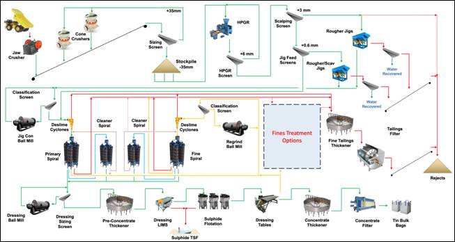
Processing Plant and Metallurgical Process · The Taronga processing plant has been designed to treat approximately 5.0 Mtpa of run-of-mine ore over the anticipated range of tin grades expected from the Ore Reserve. The process flowsheet has been specifically developed for the cassiterite-bearing hard rock mineralisation at Taronga and incorporates conventional, commercially proven comminution and gravity concentration technology, supplemented by flotation final for concentrate upgrading. · The proposed process comprises: o Primary crushing of run-of-mine ore to a nominal P80 of approximately 200 mm. o Secondary crushing to a nominal P80 of approximately 32 mm. o Size-based pre-concentration through screening and rejection of barren and low-grade coarse fractions, exploiting preferential breakage of gangue along cassiterite grain boundaries. o High Pressure Grinding Rolls (HPGR) and ball milling to liberate cassiterite. o Gravity recovery using conventional jigs, spirals and shaking tables. o Final concentrate upgrading using flotation to remove sulphide minerals and deleterious elements, producing a saleable tin concentrate · The selected flowsheet comprises well-established mineral processing technologies appropriate for the treatment of coarse cassiterite mineralisation. No novel or unproven processing technologies are incorporated into the Ore Reserve processing assumptions.
Figure 1 TMPL Tin Processing Plant
Metallurgical Testwork A comprehensive metallurgical testwork programme has been undertaken for the Taronga deposit, incorporating historical Newmont programmes and TMPL testwork completed between 2022 and 2024. The programmes have included bench-scale testing, pilot-scale investigations, mineralogical characterisation, gravity concentration, concentrate upgrading and flotation cleaning studies.
Across the combined metallurgical dataset, a consistent recovery envelope has been established for the treatment of Taronga ore using a gravity-dominated flowsheet. The available testwork indicates that tin recovery has limited correlation with head grade within the tested range, with variability primarily associated with mineralogical characteristics, cassiterite liberation, middlings generation, classification efficiency and gravity circuit performance. The recovery factor adopted for Ore Reserve estimation has been derived from the combined historical and recent metallurgical testwork dataset. Given the weak relationship between head grade and recovery, a recovery envelope approach has been adopted rather than relying solely on a direct grade-recovery relationship. The recovery relationship applied for Ore Reserve estimation is: Recovery (%) = 8.1823 × ln(Head Grade) + 73.855 This relationship provides the basis for the recovery factors applied within the Ore Reserve estimation and reflects the expected metallurgical response of the Taronga ore under the proposed flowsheet. At the time of the Ore Reserve estimate, additional metallurgical testwork on six variability samples remained in progress. This work was designed to provide further assessment of metallurgical variability and increase confidence in the established recovery envelope across the deposit. The results of this additional testwork were not incorporated into the Ore Reserve recovery assumptions; therefore, the adopted recovery factors represent the best available metallurgical information at the reporting date. The adopted recovery relationship is based on the observed relationship between head grade and tail grade, from which recovery is calculated. Direct recovery data exhibit some scatter, particularly at the lower head grades encountered in the deposit, where low tail grades approach the practical limits of analytical precision and detection. Notwithstanding this variability, the underlying head grade-tail grade relationship is considered sufficiently well established to support the adopted recovery model for estimating plant performance. Importantly, sensitivity analysis demonstrates that the project remains economically viable at recovery assumptions towards the lower end of the range reasonably supported by the available metallurgical data. The economic viability of the Ore Reserve is therefore not dependent on achieving the central or higher end of the recovery range. On this basis, the metallurgical data, adopted recovery model and demonstrated robustness of the project economics provide sufficient confidence in the recovery assumptions, as a modifying factor, to support of the Ore Reserve classification noted within. Potential recovery improvements associated with treatment of fine fractions remain subject to ongoing investigation. Fines treatment options will be evaluated on a cost-benefit basis, and any additional recovery benefits have not been included in the Ore Reserve processing assumptions. These opportunities represent potential future upside. |
||||||||||||||||||||||||
|
Environmental |
· The status of studies of potential environmental impacts of the mining and processing operation. Details of waste rock characterisation and the consideration of potential sites, status of design options considered and, where applicable, the status of approvals for process residue storage and waste dumps should be reported. |
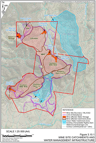
Environmental status The Taronga Project is located on property held by TMPL; · Lot 12 (DP1292270), · Lot 167 (DP753314), · Lot 83 (DP753314), · Lot 288 (DP753314) and · Lot 2 (DP1008294). The project also lies on land owned by the NSW Electricity Ministerial Holding Corporation; Lot 1 (DP1008294) and Crown land, Lot 7001 (DP92662) and, Lot 7317 (DP1166299) that are defined by historical mining lease boundaries and a Crown Road reserve linking the latter lot to Grampians Road. The open cut pits, processing facility, waste rock dumps and tailings dam are located within current mining tenure held by TMPL, namely Exploration License EL8407 and Mining Lease ML1774. TMPL has also lodged a Mining Lease Application (MLA642) for the area encompassing the principal components required to support the project's mining, processing, waste management and ancillary activities. This application was submitted to the Department of Regional NSW on December 19 2023. TMPL applied for State Significant Development (SSD-74389710), with the application exhibited from 7 October to 4 November 2025. Nine submissions were received from NSW Government agencies and public authorities, one from Glen Innes Severn Council and 15 submissions were received from individuals, 11 in support and 4 objecting to the Project. At the time of finalising this document, TMPL were preparing a Submissions Report addressing each of the submissions and responding additional agency requests for information.. Waste Rock Management Waste characterisation testing indicates that the following quantities of materials will be produced by the project:- · Potentially acid forming 7.2Mt · Uncertain 1.1Mt · Non-acid forming 27.2Mt PAF material will be encapsulated within the Northern WRE as follows:- · Prior to the placement of waste rock, the footprint of each WRE would be cleared of vegetation and stripped to refusal (i.e. all loose and organic material is removed). To limit seepage from the WRE, the exposed in situ material would then be permeability tested to meet a maximum saturated hydraulic conductivity value of 5x10⁻⁸ metres per second. Where in situ material fails to meet this specification, low permeability material would be placed, compacted and permeability tested to confirm the specification has been met. · To limit any potential interaction with underlying groundwater, basal drains would then be installed to collect and convey seepage to runoff dams that would be constructed downslope of each WRE. These basal drains would be located to utilise existing topography (gullies) graded as required. To facilitate drainage of percolated seepage, the basal drains would be constructed using slotted drainpipe, wrapped in geotextile and then be covered by 2m of suitably sized NAF material. All basal drains underlying the PAF cell section of the Northern WRE would be fitted with siphons or a U-bend at their outlet to prevent oxygen ingress into the overlying PAF material via the drain. · The Northern WRE would be developed via "bottom-up" construction methods in short 10 metre lifts. Each lift would be compacted to limit oxygen ingress and then covered by a 2m advective barrier of compacted NAF waste rock material to limit further exposure, or material oxidation by encapsulating the placed PAF and UNC waste rock material until this WRE reaches full development . · An overlaying soil cover will be placed on completion of the final WRE profile to provide a vegetated store and release layer. Tailings Storage The waste material generated from ore processing will comprise the following. Material characterisation testing indicates that these materials may be classified as shown in parenthesis. · coarse rejects (Uncertain), · coarse and fine tailings (PAF - low capacity), · flotation tailings (PAF). The coarse rejects and coarse and fine tailings will be dewatered and placed within the Co-disposal Area (CDA). These waste streams will be transported via conveyor to the CDA for final placement and compaction via dozer. The general design parameters for the CDA are as follows: o Maximum height: 110m. o Average batter slope: 3H:1V. o Footprint: 60ha o . The flotation tailings will be pumped for disposal in a small valley embankment residue storage facility (RSF) constructed in accordance with the methodologies of Dam Safety NSW, the Australian National Council on Large Dams (ANCOLD, 2019) and the Global Industry Standard on Tailings Management (ICMM, 2020). Decant water from the RSF will be returned to the processing plant for reuse within the process. ATC Williams has prepared the designs for the CDA and sulphide RSF to provide sufficient storage capacity for the waste material from all scheduled Taronga ore. Water Management Water management and supply at the Taronga Project is presented schematically in the following figure. Key controls Include:- · Runoff Dams (RODs) to capture runoff and seepage from the catchments of WREs and the CDA. · Mine Water Dam (MWD) and Balance Storage used to capture and store mine-affected runoff from the Process Plant and ROM Stockpile Area; provide storage capacity for pit and ROD dewatering; and, provide supply for reuse within the Process Plant. · RSF for storage and reuse within the Process Plant of tailings decant water. · Balance Storage to provide a contingency storage, receiving pumped transfers from the Runoff Dams to reduce risk of discharge and improve the Project's water supply reliability.
Figure 2 Water Management Dams
· Clean Water Dam to capture clean water as supply to the Raw Water Tank (supplementing external groundwater supply). Other structures include drainage channels and bunds for both clean water diversion and management of mine affected and stormwater. Erosion control, sediment ponds and runoff dams are used to manage site water runoff. These structures will be retained for long-term water management. The water storage dams will be used to store contact water from the general project area and open cuts for reuse within the processing circuit where practicable. Rehabilitation A Rehabilitation Management Plan describing rehabilitation of the Mine Site will be prepared, including final landform, rehabilitation objectives which will be required to be approved. A Rehabilitation Cost Estimate will also be required to be prepared and a rehabilitation security will be required to be provided prior to the commencement of mining operations. The final landform for the Mine Site will include the following. · Two bunded and fenced final voids, the Northern and Southern open cut pits. · Shaped and rehabilitated landforms of the Northern and Southern WRE · Capped, shaped and rehabilitated landforms of the CDA and the RSF. · Rehabilitated landforms largely consistent with the existing topography associated with the proposed soil stockpiling, processing and infrastructure areas. · Water management structures (where required). · Internal access roads reduced in width to that required for the proposed final land uses. All infrastructure not required for the final land use would be removed or reduced in size Final land uses domains for the Mine Site will include the following. Domain nomenclature reflects that required for the RMP. · Domain A - Native Ecosystem Areas · Domain B - Agricultural Grazing · Domain I - Infrastructure Area · Domain J - Final Void Environmental Assessment Outcomes Biodiversity
The biodiversity assessment was completed in accordance with the Biodiversity Assessment Methodology (BAM) 2020. That assessment identified the following within the Project Site. · A total of four Plant Community Types (PCTs) were recorded, one of which is associated with the Threatened Ecological Community (TEC) White Box-Yellow Box - Blakelys Red Gum Grassy Woodland and derived Native Grassland. This TEC is listed as Critically Endangered under the NSW Biodiversity Conservation Act 2016. · Two flora species, namely Velvet Wattle and Bluegrass, listed as threatened under the EPBC Act were recorded. Impacts to Velvet Wattle were deemed a "Controlled Action" by the Commonwealth and will be assessed under the Bilateral Agreement between the State and Commonwealth Governments. · Five fauna species that are listed as threatened under the EPBC Act were recorded. Impacts to Border Thick-tailed Gecko were deemed a "Controlled Action" by the Commonwealth and will be assessed under the Bilateral Agreement between the State and Commonwealth Governments. · The presence of 18 fauna species listed as threatened under the BC Act were recorded with four of these species requiring retiring of biodiversity offset credits, namely: o Barking Owl o Squirrel Glider o Koala o Border Thick-tailed Gecko · The Project would result in the disturbance of approximately 315.2ha of native vegetation. · To account for Project-related impacts to biodiversity values, the Applicant would be required to retire 8,214 Ecosystem Credits and 48,882 Species Credits. Almost all required credits would be retired through the establishment of a Biodiversity Stewardship Site on Applicant-owned land immediately north of the Mine Site. Any outstanding credit liability would be retired by the Applicant via other approved methods such as the purchase of credits held by third parties or payment to the Biodiversity Conservation Trust.
Air Quality The Air Quality Impact Assessment (AQIA) determined that the Project's predicted contributions of airborne particulates and NO2 emissions, coupled with existing background concentrations would comply with all applied assessment criteria at privately-owned sensitive receivers. Furthermore, no exceedance of individual toxic pollutants or metals criteria at privately-owned sensitive receivers was predicted. However, the AQIA did predict exceedances of arsenic criterion on a steep and forested section of privately-owned lands immediately adjacent to the Mine Site. The Applicant has consulted with the owners of this land in relation to this matter. At the time of finalisation of this document, an updated AQIA was in preparation in response to the EPA's submission on the EIS.
Greenhouse gas The Greenhouse Gas determined that the Project would, at a maximum, generate Scope 1 and Scope 2 emissions totalling 18,404t of carbon dioxide equivalent (CO2-e) in any given year
Noise The Noise Impact Assessment demonstrated that noise emissions from the Mine Site would satisfy all relevant assessment criteria, including those for sleep disturbance, road traffic noise and annoying noise characteristics.
Blasting and Vibration The Blasting and Vibration Impact Assessment identified that all potential Project-related blasting and vibration impacts during mining operations could be managed to ensure that ground vibration, airblast and flyrock criteria are not exceeded at any privately-owned sensitive receiver. The assessment considered that the risks from blasting to the Transgrid Grampians Ridge radio transmissions facility can be adequately mitigated by establishing an initial 40m wide No Blast Zone around this facility
Surface Water The Surface Water Impact Assessment demonstrated that the Project can be constructed and operated with minimal impacts to the surrounding surface water environment, with management and mitigation measure to ensure this.
Groundwater The Groundwater Impact Assessment utilised a calibrated numerical groundwater model that was independently peer reviewed and deemed "fit for purpose". The assessment predicted that, over the Project-life, the annual direct groundwater take would be between 111.8ML/year and 137.0ML/year. This groundwater take would arise from evaporative losses from the open cut pits and water extracted from the proposed production bores. Indirect take, or reduced groundwater flow to local streams would be between 26.2ML/year and 72.1ML/year. TMPL holds Water Access Licence 44962 with 636-unit shares of groundwater which exceeds all potential groundwater extraction requirements.
Additional predictions include the following. · Groundwater drawdown would be limited to a few kilometres from the Mine Site and mostly within Applicant-owned land. · Groundwater levels are predicted to fully recover in the area surrounding the production bore field following the cessation of mining. · There would be no impacts to registered groundwater users and groundwater dependent ecosystems would remain unaffected. · The Project would not result in groundwater quality impacts.
Human Health The Human Health Risk Assessment concluded that human health risks from inhalation exposure to particulates, metals, nitrogen oxides and respirable crystalline silica were low and that chronic risks to human health, as well as impacts to drinking water and agricultural products, from cumulative exposure relevant to metals are also considered negligible. Aboriginal Heritage The Aboriginal and Historical Cultural Heritage Assessment identified a single Aboriginal object within the Mine Site. The object would not be disturbed.
|
||||||||||||||||||||||||
|
Infrastructure |
· The existence of appropriate infrastructure: availability of land for plant development, power, water, transportation (particularly for bulk commodities), labour, accommodation; or the ease with which the infrastructure can be provided, or accessed. |
Infrastructure required for the mining operations at Taronga has been described above under Mining factors or assumptions. Overall site infrastructure requirements for the TMPL project include the following:- · 5Mtpa process plant as described under Metallurgical factors or assumptions · ROM crusher and stockpile area · Crushed ore stockpile area · Power supply comprising:- o 11MW Solar, 5 x 2.3 MW gas powered generators and 1 x 2MW diesel powered backup generator o HV power site transmission and distribution. o LV site power transmission and distribution. · Diesel fuel storage for mobile equipment and ANFO explosives manufacturing. · Warehouse and workshop including reagent storage · Administration buildings, toilet, meal room, change house · Communications o Internet and phone comms system. o Emergency response system. o UHF radio system · Raw water supplied from a Bore Field located on TMPL owned property, with back up from fresh water dams and run-off dams located on TMPL owned property. · Potable water from a water treatment plant that will be installed on the Raw Water tank pad · Drive-in drive-out Camp Village at Glen Innes, including o 52 En-Suite Single Rooms in standard 4 room blocks o Storage Building with lockers for off-site personnel o Shared Laundry buildings o Camp Office Building o Ablution Blocks o Kitchen / Cold Storage / Dry Storage / Dinning Hall for 85-90 people o Wet Mess with outdoor covered seating area o Recreational / Gymnasium Block o All weather Walkway System o Carpark o Bus Stop. · Medical Room and Emergency Services on-site o located adjacent to the site main operations offices o Medical services provided by trained staff supported by the New South Wales Ambulance Services o On-site ambulance for first aid response and evacuation. o Emergency fire truck stationed at the same sheltered parking bay. The southern wall of the North Pit will come to within approximately 20m of the existing communications tower and within 7m of associated infrastructure situated on Lot 1 DP 1008294 (owned by the NSW Electricity Transmission Ministerial Holding Corporation) and an adjacent section of Lot 2 DP 1008294 (sub-leased from TMPL). This site is part of the NSW Public Safety Network that is used by frontline emergency services, government agencies and essential services to communicate via radio handsets and other devices during emergencies. It comprises the following telecommunications equipment and associated infrastructure:- · 28m lattice tower. · 30m monopole tower. · Equipment Shelters. · Antennae. · Solar arrays. At this stage, Mincore and TMPL consider that this infrastructure does not require relocation. However, appropriate geotechnical, structural, blasting and vibration assessments are required to address this uncertainty and risk. |
||||||||||||||||||||||||
|
Costs |
· The derivation of, or assumptions made, regarding projected capital costs in the study. · The methodology used to estimate operating costs. · Allowances made for the content of deleterious elements. · The derivation of assumptions made of metal or commodity price(s), for the principal minerals and co- products. · The source of exchange rates used in the study. · Derivation of transportation charges. · The basis for forecasting or source of treatment and refining charges, penalties for failure to meet specification, etc. · The allowances made for royalties payable, both Government and private. |
Project Capital costs The Taronga capital cost estimate is AUD 297.18 million including the following items:- · Mining - o Mine Infrastructure Area o First fill consumables and parts o Critical Spares o Pre-production earthworks including development of haul roads and initial open cut benches, and WRE preparation o Note that fleet costs are handled as lease costs within the operating costs. · Processing o Process plant o First fill reagents o TSF o Critical Spares · Site general infrastructure Sustaining Capital is included in the processing operating costs $/t ore processed. Project operating costs Project operating costs are summarised below:- AUD 7.22/t ore mining AUD 5.91/t ore processing, including crushing AUD 1.53/t ore G&A AUD 0.33/t ore for ongoing rehabilitation AUD 15.00/t ore total operating cost Tin realisation costs, including concentrate freight, deleterious element penalties and treatment charges, are estimated at 6.59% of the tin price (see Revenue Factors below). · AMDAD estimated the mining costs for Owner Mining based on lease of used equipment. Only drill and blast would be contracted. The estimated variable cost equates to AUD 3.84/tonne of material mined. The mining cost also includes AUD 1.06/t ore, or AUD 0.63/t mined, for mining management, supervision and technical services, giving an overall mining cost of AUD 4.47/t mined. · Mincore estimated processing costs of AUD 5.91/t ore as follows:- o Power costs based on Hybrid Power Station using Solar and Gas with life of mine power cost of 11.65c/kWh for AUD1.58/t ore o AUD1.94/t ore for Labour o AUD 0.62/t ore for Maintenance o AUD 1.42/t ore for Reagents and Consumables cost o AUD 0.35/t ore for analytical, vehicles and other minor costs · Mincore estimated the General and Administration costs of AUD 2.02/t of ore as follows:- o AUD 0.75/t ore for Labour cost o AUD 0.78/t ore for external services cost
|
||||||||||||||||||||||||
|
Revenue factors |
· The derivation of, or assumptions made regarding revenue factors including head grade, metal or commodity price(s) exchange rates, transportation and treatment charges, penalties, net smelter returns, etc. · The derivation of assumptions made of metal or commodity price(s), for the principal metals, minerals and co-products. |
Tin Revenue The ore reserve cutoff grade and financial modelling used a tin price of US$40,000/t and exchange rate of 1 AUD = USD 0.70, equating to AUD$57,143/t. As part of the financial modelling, sensitivity runs were undertaken at higher and lower tin prices with a calculated breakeven project price (NPV8 =0) of US$31,042/tonne tin. On 1 July 2026, the spot tin price was approximately US$51,600/t (LME web page) and the exchange rate was 1 AUD = USD 0.69, equating to approximately AUD$74,800/t. Realisation costs For the cutoff grade and financial modelling, selling/realisation costs include:- · Tin concentrate transport cost of US$119/wmt · Tin concentrate treatment cost of US$495/dmt · Penalties equating to US$491/dmt · Tin payability of 96.0% · The NSW Government charges a tin royalty of 4% on tin revenue net of processing and associated Administrations costs. |
||||||||||||||||||||||||
|
Market assessment |
· The demand, supply and stock situation for the particular commodity, consumption trends and factors likely to affect supply and demand into the future. · A customer and competitor analysis along with the identification of likely market windows for the product. · Price and volume forecasts and the basis for these forecasts. · For industrial minerals the customer specification, testing and acceptance requirements prior to a supply contract. |
The following comments are made in relation to market assessment:- · Future tin demand growth looks set to be driven by the impracticality of further miniaturisation in the electronics sector, and new demand from the solar sector. · The maximum annual average tin price was US $69,733 in 1981 and the minimum US $9,995 in 2002. · The trailing 5 year average price is US $33,230. Average tin prices are shown in the table below in US$ and AUD.
· For cash flow and production scheduling purposes a price of US $40,000 per tonne has been used. This represents a moderate discount to the trailing 5-year average price. · Given the strong outlook for tin demand growth and modest outlook for new sources of supply, there is a level of conservatism in this price forecast. · The tin concentrate has been analysed for tin grade and other key elements. This concentrate is acceptable within the market. The net price for financial modelling include penalties for some elements in the concentrate and also the average grade of the concentrate |
||||||||||||||||||||||||
|
Economic |
· The inputs to the economic analysis to produce the net present value (NPV) in the study, the source and confidence of these economic inputs including estimated inflation, discount rate, etc. · NPV ranges and sensitivity to variations in the significant assumptions and inputs. |
Project cost/financial model · Reynolds Consulting prepared a financial model for the project in Excel using operating and capital cost estimates described in the "Costs" section above, and based on a tin price of US $40,000/t. The model uses the FS mining schedule prepared by AMDAD, with tin processing recovery to concentrate defined by Mincore. · The financial model shows a pre-tax discounted cashflow (DCF) at 8% discount rate, of approximately AUD 292 million and a pre tax IRR of 24.4%. The model indicates that the DCF is still positive at a tin price of US$31,042/t. · Reynolds Consulting has confirmed that its economic analysis based on the Taronga Ore Reserves demonstrates that the planned operations are economically viable given the price and exchange rate assumptions. |
||||||||||||||||||||||||
|
Social |
· The status of agreements with key stakeholders and matters leading to social license to operate. |
TMPL undertook extensive engagement with the local and wider community and government agencies as follows:- Community Community engagement included the following. · Landholder (Near Neighbour) Engagement Individual and group discussions with neighbouring landholders and other near neighbours have been undertaken since 2022. These meetings, using information tailored to the individual landholder's property, were held to discuss the outcomes of the various assessments undertaken for the EIS. In all cases, these discussions were informative, cordial and courteous with most near neighbours appearing receptive to the Project. Whilst some near neighbours held reservations about the Project, all recognised the benefits it would bring to Emmaville and the local area.
TMPL continues to maintain and encourage regular contact with near neighbours. In person meetings and phone calls are made regularly with Community Newsletters also distributed as the Project has progressed. A central point of contact, via the Community Relations Officer, has also been established to ensure that any questions or concerns raised are addressed in an appropriate, consistent, and timely manner.
· Emmaville Community TMPL has undertaken extensive engagement with the Emmaville community, principally the Emmaville-based Community Relations Officer. In addition, TMPL has also hosted town hall style Community Information Sessions, as follows. o July 2022 o November 2023 o July 2025
· Glen Innes Community A community drop-in session was held in July 2025 at Glen Innes Airport, the location of the proposed Mine Camp.
· Aboriginal Community Engagement Eight Aboriginal Parties registered to be consulted in relation to the Project. Each were consulted in relation to the heritage assessment and various members attended the field surveys.
In addition, in November 2023, TMPL held an engagement meeting with Indigenous stakeholders at Glen Innes RSL Club. In all, 30 local Indigenous people participated, and the meeting was also live streamed for individuals and groups who could not attend. A key outcome of this meeting was TMPL agreeing to conducting two walkovers of the proposed Mine Site for Indigenous stakeholders that were held separate to the field surveys being undertaken in accordance with DECCW (2010b). TMPL also provided a commitment to working with all indigenous parties recognised for the area on employment and educational pathways.
TMPL also met with members of the Moombahlene Local Aboriginal Land Council in July 2025. This meeting was to discuss matters relating to the Section 265 (Mining Act) Compensation Agreement that was executed between TMPL and Crown Land NSW, should tenure of the subject lands be transferred to Moombahlene Local Aboriginal Land Council. These discussions included the proposed structure of any future agreement, including the transfer of royalties payable, youth employment opportunities and the nature of any future compensation arrangements.
Business Community Engagement Extensive consultation with the local business community has occurred both formally through Project update meetings and informally through TMPL's employees and management team sourcing local products and services. TMPL is now well known in the area and is purchasing local provisions, hiring equipment and arranging accommodation in local hotels.
Government Agencies and Utility Providers TMPL consulted with the following government agencies and utility providers. · Department of Climate Change, Energy, the Environment and Water - Biodiversity, Conservation and Science · Department of Climate Change, Energy, the Environment and Water - Heritage · Department of Climate Change, Energy, the Environment and Water - Water · Department of Planning, Housing and Infrastructure - Crown Lands · Department of Primary Industries and Regional Development - Agriculture · Department of Primary Industries and Regional Development - NSW Resources · Environment Protection Authority · Transport for NSW · Transgrid / Lumea
Social Impact Assessment The Social Impact Assessment relied upon a comprehensive program of community engagement and feedback received. Whilst some of the Mine Site's near neighbours were concerned about the Project's effect on their way of life, road infrastructure and agricultural operations, most of those living further away, including within Emmaville, were highly positive about the Project, citing potential employment, economic activity, and diversification of the local economy as likely positive contributions. A range of community engagement and enhancement strategies are proposed to maximise the social benefit of the Project including the following. · Negotiation of a Planning Agreement with Glen Innes Severn Council. · A commitment to train and employ local residents and source goods and services from local businesses where practical. · A commitment to employing and contracting local First Nations people and businesses where practical. · Commitment to open communications with local people and proactively responding to any grievances as they arise. The Social Impact Assessment concluded the Project would deliver a net positive social impact to the local community and to the region.
|
||||||||||||||||||||||||
|
Other |
· To the extent relevant, the impact of the following on the project and/or on the estimation and classification of the Ore Reserves: · Any identified material naturally occurring risks. · The status of material legal agreements and marketing arrangements. · The status of governmental agreements and approvals critical to the viability of the project, such as mineral tenement status, and government and statutory approvals. There must be reasonable grounds to expect that all necessary Government approvals will be received within the timeframes anticipated in the Pre-Feasibility or Feasibility study. Highlight and discuss the materiality of any unresolved matter that is dependent on a third party on which extraction of the reserve is contingent. |
TMPL has confirmed that there are no other material issues or risks that could impact on the project and on the estimation of the ore reserves.
|
||||||||||||||||||||||||
|
Classification |
· The basis for the classification of the Ore Reserves into varying confidence categories. · Whether the result appropriately reflects the Competent Person's view of the deposit. · The proportion of Probable Ore Reserves that have been derived from Measured Mineral Resources (if any). |
Reserve Classification The contributing experts consider that the critical mining, metallurgical, infrastructure, cost, revenue, environmental, social and permitting assumptions defined as part of the Taronga Feasibility Study are generally at a sufficiently high level of confidence for estimation of Proved Ore Reserves. As noted under Metallurgical factors or assumptions , the grade-based processing recovery relationship is not at the highest level of confidence, particularly in relation to lower head grades. However, sensitivity analysis demonstrates that the project would still be economically viable towards the lower end of the range reasonably supported by the available metallurgical data. The confidence category applied to the Ore Reserves therefore corresponds with the category of the Mineral Resources. The estimated Proved Ore Reserves are the economically mineable part of the Measured Mineral Resources and the estimated Probable Ore Reserves are the economically mineable part of the Indicated Mineral Resources. No portion of the Probable Ore Reserves has been derived from the Measured Mineral Resource.
General Project Risks Elements of risk to the overall project and ore reserves are summarised below:- · Significant changes to the US$ tin price and/or exchange rate. · Funding difficulties · Delays to the process plant start up due to longer than forecast construction time and commissioning issues. · Delays to the mining 'start up' phase due to difficulty resourcing competent mining personnel and reliable equipment · Mining impacts from geotechnical factors · Facility design/construction/operational impacts from geotechnical factors · Grade and tonnage recovery variances from uncertainty in the estimated resources. · Concentrate production variances from uncertainty in the processing recovery · Uncertainty with external water supply and reliability (for processing operations). · Uncertainty regarding ongoing integrity of the existing communications towers and infrastructure and possible requirement for their replacement. Taking into account the risks and uncertainties noted above, the mine plan and Ore Reserve appropriately reflects the Competent Person's view of the deposit. |
||||||||||||||||||||||||
|
Audits or reviews |
· The results of any audits or reviews of Ore Reserve estimates. |
· No audits or reviews of the latest resource estimate and the reserve estimate have been undertaken.
|
||||||||||||||||||||||||
|
Discussion of relative accuracy/ confidence |
· Where appropriate a statement of the relative accuracy and confidence level in the Ore Reserve estimate using an approach or procedure deemed appropriate by the Competent Person. For example, the application of statistical or geostatistical procedures to quantify the relative accuracy of the reserve within stated confidence limits, or, if such an approach is not deemed appropriate, a qualitative discussion of the factors which could affect the relative accuracy and confidence of the estimate. · The statement should specify whether it relates to global or local estimates, and, if local, state the relevant tonnages, which should be relevant to technical and economic evaluation. Documentation should include assumptions made and the procedures used. · Accuracy and confidence discussions should extend to specific discussions of any applied Modifying Factors that may have a material impact on Ore Reserve viability, or for which there are remaining areas of uncertainty at the current study stage. · It is recognised that this may not be possible or appropriate in all circumstances. These statements of relative accuracy and confidence of the estimate should be compared with production data, where available. |
The resource model from which the Ore Reserve is estimated does not include measures of relative accuracy other than what is implied by the resource classification. No simulations or probabilistic modelling have been undertaken on the Ore Reserves that would provide a meaningful measure of relative accuracy. The Modifying Factors are considered to be supported by studies generally at FS level. Uncertainty in processing recovery relationship has been addressed by sensitivity analysis. Potential upside to the estimated Ore Reserve is represented by:- · Potential for extraction of Inferred Resource within and below the FS open cut design · Potential for a larger optimised pit shell based on the updated economic parameters, processing recoveries and MRE, · Potential for further improvement in process recovery with fines treatment
|
RNS may use your IP address to confirm compliance with the terms and conditions, to analyse how you engage with the information contained in this communication, and to share such analysis on an anonymised basis with others as part of our commercial services. For further information about how RNS and the London Stock Exchange use the personal data you provide us, please see our Privacy Policy.

Latest directors dealings
- 13 hours ago Tesco
- 14 hours ago Dr. Martens
- 14 hours ago YouGov
- 15 hours ago Vistry Group
- 15 hours ago Cohort