EIS Geophysics Application Granted at Paterson, WA
Summary by AI BETAClose X
20 May 2026
Cloudbreak Discovery Plc
('Cloudbreak', or 'the Company')
EIS Geophysics Application Granted at Paterson, WA
Cloudbreak Discovery PLC (LSE:CDL), a London Stock Exchange Main Market listed company, is pleased to advise that an application for a co-funded geophysics program has been granted covering the Company's Paterson Project located ~40km south of the Telfer Gold-Copper Mine and ~60kms SW of the Havieron Gold-Copper Mine in the Paterson region of Western Australia ("Paterson") (Figure 1).
· Geophysics program award under the West Australian Government's Exploration Incentive Scheme (EIS) covering the Paterson Project
· Co-funded geophysics grant of up to $269,270 ($438,540 project overall cost, 50% funded by government plus a one-off payment of up to $50,000) to undertake widespread, semi-regional, MobileMT Surveying
· MobileMT surveying in the Paterson region has already proven to be effective in mapping resistivity contrasts, structure and geological complexity / direct targets under considerable cover depths
· Cloudbreak has built a large, strategic landholding within the Paterson region (~888km²) which is deemed prospective for copper-gold-molybdenum mineralisation.
The Paterson Project represents a strategic 888km² land package in Western Australia's premier exploration frontier, located just 40km from the 15-million-ounce Telfer Gold-Copper Mine. With compelling historical drill results (Cu, Au and Mo) and multiple untested geophysical targets, this project offers substantial discovery potential in a region renowned for major mining operations and new discoveries.
Commenting on the EIS Co-Funding grant, MD Tom Evans said: "We are delighted to secure EIS co-funding support from the Western Australian Government for this major MobileMT program across our Paterson Project. The survey represents a significant step forward in systematically unlocking the potential of our 888km² landholding in one of Australia's most prospective copper-gold districts.
The MobileMT program will provide critical regional-scale geological and structural data beneath cover, helping us refine existing targets and identify new priority areas for drilling. Importantly, the grant allows us to accelerate exploration while materially reducing the cost burden to shareholders.
With increasing industry attention on the Paterson region following several major discoveries, we believe Cloudbreak is strongly positioned to advance a large-scale exploration strategy in a highly sought-after mineral province.
Importantly, the Company remains fully funded for its planned exploration activities, including the upcoming Darlot drill campaign, which I look forward to updating the market on shortly."
Commenting on the EIS Co-Funding grant and geophysical technical aspects, Consultant Geophysicist Russell Mortimer said: "Co-funded, systematic MobileMT surveying over the Paterson Project will greatly enhance/support geological and structural mapping to deep level across the full tenement package, with the ultimate aim to highlight and confirm prospect scale priority targets supported by all other available geophysical data/methods"
|
Figure 1 - Paterson Project - Regional Location/Tenement Package Plan
MobileMT Survey and Forward Program The proposed MobileMT AEM survey encompasses approximately 2,771 line kms. Coverage is proposed to be acquired at 400m spaced survey lines (flown NE-SW) to provide effective exploration for large mineral systems (Figure 2). Line spacing is believed to be suitable for detection of sulphide bodies/alteration systems of significant areal size/footprint at reasonable exploration depth under cover. Planned survey lines are designed to be roughly perpendicular to the average geological strike, which is believed optimal. Survey height/sensor height is proposed to be ~60-80m above ground level. This modern passive AEM survey is appropriate for the exploration target/geological model, as it has the ability to rapidly map structure, conductors/resistors (relative resistivity contrasts) under significant cover/overburden over broad project areas. Such surveying has been very valuable for a number of exploration groups within the Paterson region in recent years to provide direct exploration vectors - St George, Wishbone and Rincon. |
|
|
|
The survey will be flown by Expert Geophysics in the coming months with their proprietary MobileMT AFMAG system and interpretation will be completed by Russell Mortimer of Southern Geoscience Consultants (SGC). MobileMT is an airborne natural-field electromagnetic technology that maps subsurface resistivity by measuring variations in naturally occurring EM signals over a broad frequency range. The heliborne system is designed for broadband acquisition (26 Hz to 21 kHz), providing sensitivity to both shallow and deep structures. The resulting products are geology-meaningful resistivity images that support 3D resistivity mapping, structural interpretation, and targeting. |
|
|
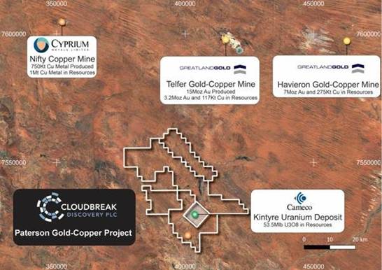
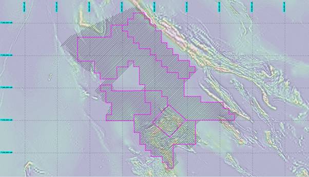
Figure 2 - Paterson Project - Proposed MobileMT Survey Coverage 2026 over Regional Aeromagnetic Imagery
This announcement contains information which, prior to its disclosure, was inside information as stipulated under Regulation 11 of the Market Abuse (Amendment) (EU Exit) Regulations 2019/310 (as amended).
-END-
For Further Information, please contact:
|
Cloudbreak Discovery PLC |
Peter Huljich, Chairman Tom Evans, Managing Director |
Tel: +44 207 887 6139 Tel: +44 7851 703440 |
|
AlbR Capital Limited (Financial Adviser) |
David Coffman / Dan Harris |
Tel: +44 207 469 0930 |
|
Marex Financial (Broker) |
Angelo Sofocleous / Matt Bailey |
Tel: +44 (0) 207 655 6000 Email: corporate@marex.com |
About Cloudbreak Discovery PLC
LSE listed Cloudbreak Discovery PLC is a leading gold, precious and base metals resource explorer. Cloudbreak is focused on mineral exploration in Western Australia with the aim of bringing near-term cashflow and driving shareholder value. Through its wholly owned subsidiaries, the Company will develop its array of mineral assets, whilst continuing to generate new projects with a particular focus on commodities with high intrinsic value. Cloudbreak's generative model across the mineral sector enables a multi-asset approach to investing in the commodity cycle.
The information presented herein that relates to Exploration Results from information compiled and reviewed by Russell Mortimer, a Competent Person who is a Member of The Australian Institute of Geoscientists and fairly represents this information. Mr Mortimer has sufficient experience relevant to the style of mineralisation and type of deposit under consideration, and to the activities undertaken, to qualify as a Competent Person as defined in the 2012 Edition of the Joint Ore Reserves Committee (JORC) Australasian Code for Reporting of Exploration Results, Mineral Resources and Ore Reserves. Mr Mortimer is an independent Consultant Geophysicist at Southern Geoscience Consultants Pty Ltd and consents to the inclusion in the report of the matters based on his information in the form and context in which it appears.
RNS may use your IP address to confirm compliance with the terms and conditions, to analyse how you engage with the information contained in this communication, and to share such analysis on an anonymised basis with others as part of our commercial services. For further information about how RNS and the London Stock Exchange use the personal data you provide us, please see our Privacy Policy.

Latest directors dealings
- 43 minutes ago FirstGroup
- 46 minutes ago Prudential
- 1 hour ago RM Infrastructure Income
- 1 hour ago Touchstar
- 1 hour ago United Utilities Group